
Create successful ePaper yourself
Turn your PDF publications into a flip-book with our unique Google optimized e-Paper software.
11 DEC 2014<br />
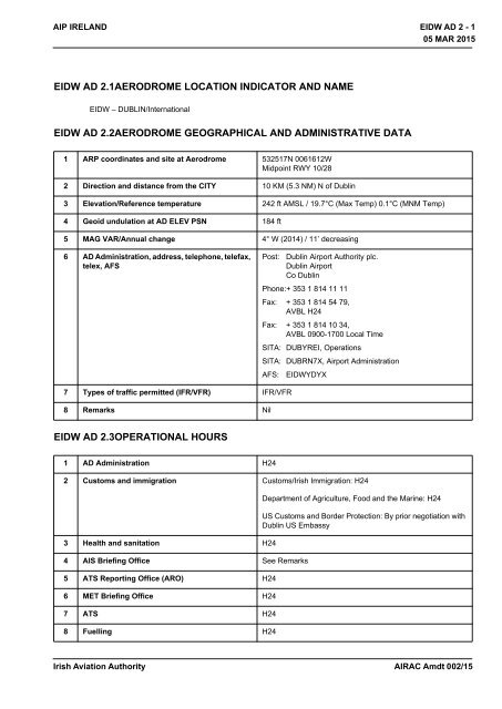
AIP IRELAND<br />
<strong>EIDW</strong> AD 2 - 1<br />
05 MAR 2015<br />
<strong>EIDW</strong> AD 2.1AERODROME LOCATION INDICATOR AND NAME<br />
<strong>EIDW</strong> – DUBLIN/International<br />
<strong>EIDW</strong> AD 2.2AERODROME GEOGRAPHICAL AND ADMINISTRATIVE DATA<br />
1 ARP coordinates and site at Aerodrome 532517N 0061612W<br />
Midpoint RWY 10/28<br />
2 Direction and distance from the CITY 10 KM (5.3 NM) N of Dublin<br />
3 Elevation/Reference temperature 242 ft AMSL / 19.7°C (Max Temp) 0.1°C (MNM Temp)<br />
4 Geoid undulation at AD ELEV PSN 184 ft<br />
5 MAG VAR/Annual change 4° W (2014) / 11’ decreasing<br />
6 AD Administration, address, telephone, telefax,<br />
telex, AFS<br />
Post:<br />
Dublin Airport <strong>Authority</strong> plc.<br />
Dublin Airport<br />
Co Dublin<br />
Phone:+ 353 1 814 11 11<br />
Fax: + 353 1 814 54 79,<br />
AVBL H24<br />
Fax: + 353 1 814 10 34,<br />
AVBL 0900-1700 Local Time<br />
SITA: DUBYREI, Operations<br />
SITA: DUBRN7X, Airport Administration<br />
AFS: <strong>EIDW</strong>YDYX<br />
7 Types of traffic permitted (IFR/VFR) IFR/VFR<br />
8 Remarks Nil<br />
<strong>EIDW</strong> AD 2.3OPERATIONAL HOURS<br />
1 AD Administration H24<br />
2 Customs and immigration Customs/<strong>Irish</strong> Immigration: H24<br />
3 Health and sanitation H24<br />
4 AIS Briefing Office See Remarks<br />
5 ATS Reporting Office (ARO) H24<br />
6 MET Briefing Office H24<br />
7 ATS H24<br />
8 Fuelling H24<br />
Department of Agriculture, Food and the Marine: H24<br />
US Customs and Border Protection: By prior negotiation with<br />
Dublin US Embassy<br />
<strong>Irish</strong> <strong>Aviation</strong> <strong>Authority</strong><br />
AIRAC Amdt 002/15
11 DEC 2014<br />
<strong>EIDW</strong> AD 2 - 2<br />
05 MAR 2015<br />
AIP IRELAND<br />
9 Handling H24<br />
10 Security H24<br />
11 De-icing H24<br />
12 Remarks Airport closed on 25th December. Exact hours advised by<br />
NOTAM.<br />
PIB AVBL from AIS, Shannon see GEN 3.1.5<br />
<strong>EIDW</strong> AD 2.4HANDLING SERVICES AND FACILITIES<br />
1 Cargo handling facilities: Available from Aer Lingus, Swissport, Sky Handling.<br />
2 Fuel/oil types JET A1Fuel<br />
Oil Grades 100, 100W, 100U, 100E, 120, W80, E80.<br />
Turbo Oils 750, 390, 2380<br />
3 Fuelling facilities/capacity JET A1 H24 No limitations.<br />
4 De-icing facilities On request from Aer Lingus, Gate <strong>Aviation</strong>, Ryanair,<br />
Swissport.<br />
5 Hangar space available for visiting aircraft On request from Dublin Aerospace.<br />
6 Repair facilities for visiting aircraft Repair facilities from Dublin Aerospace.<br />
7 Remarks Passenger Handling: Available from Aer Lingus, Swissport,<br />
Sky Handling, Signature Flight Support (Corporate), Universal<br />
<strong>Aviation</strong> (Corporate).<br />
Catering: Available from Gate Gourmet and Alpha Catering<br />
General <strong>Aviation</strong> Handling: Signature Flight Support,<br />
Universal <strong>Aviation</strong> (Other ground handlers listed above on<br />
request)<br />
Fixed ground power: Stands 400-410<br />
Aircraft Power Plant Test Runs: See <strong>EIDW</strong> AD 2.20<br />
<strong>EIDW</strong> AD 2.5PASSENGER FACILITIES<br />
1 Hotels Hotels At Airport (477 beds) and in Dublin area<br />
2 Restaurants 850 seats<br />
3 Transportation Buses, taxis, car hire<br />
4 Medical facilities First aid treatment, Hospitals in Dublin, 8km<br />
5 Bank and Post Office Bank of Ireland, Dublin Airport<br />
No Post Office at Airport<br />
6 Tourist Office At Airport<br />
AIRAC Amdt 002/15<br />
<strong>Irish</strong> <strong>Aviation</strong> <strong>Authority</strong>
11 DEC 2014<br />
AIP IRELAND<br />
<strong>EIDW</strong> AD 2 - 3<br />
05 MAR 2015<br />
7 Remarks Short term Car Parking - 3000 spaces<br />
Long term Car Parking - 16000 spaces<br />
Executive lounges - Anna Livia<br />
<strong>EIDW</strong> AD 2.6RESCUE AND FIRE FIGHTING SERVICES<br />
1 AD category for fire fighting Required CAT 9<br />
Available CAT 9<br />
2 Rescue equipment Emergency lighting and other equipment adequate to meet<br />
Category 9 requirements<br />
3 Capability for removal of disabled aircraft Coordinator<br />
Phone:+ 353 1 814 1027<br />
Phone:+ 353 87 239 2277<br />
Capability 39,000kg<br />
(Utilising equipment available at Dublin Airport)<br />
4 Remarks Communication with Rescue and Fire Fighting Service:<br />
Frequency 121.600 MHz AVBL for direct communication<br />
between ACFT and Rescue and Fire Fighting Service.<br />
121.600 MHz should be requested initially via ATC. Call sign<br />
for the Rescue and Fire Fighting Service is ‘Dublin Fire’. It is<br />
mandatory for both ACFT and Rescue and Fire Fighting<br />
Service to maintain contact with ATC at all times.<br />
ATC do not have access to 121.600 MHz.<br />
Frequency 121.600 MHz is H24 and AVBL within 10 NM<br />
radius of Dublin Airport<br />
<strong>EIDW</strong> AD 2.7SEASONAL AVAILABILITY - CLEARING<br />
1 Type(s) of clearing equipment High speed sweepers and ploughs, snow blowers, de-icing<br />
vehicles, spreaders, apron units – contact Aerodrome<br />
Administration for details<br />
2 Clearance priorities 1. Duty runway and associated taxiways together with<br />
apron areas<br />
2. Other areas<br />
3 Remarks Annual snow plan available from the Aerodrome Operator on<br />
request.<br />
See also AD 1.2.<br />
<strong>EIDW</strong> AD 2.8APRONS, TAXIWAYS AND CHECK LOCATION DATA<br />
1 Apron surface and strength Surface: CONC Strength: PCN 70/R/C/W/U<br />
2 Taxiway width, surface and strength TAXIWAY WIDTH SURFACE STRENGTH<br />
A 23 M ASPH PCN 70/R/C/W/U<br />
B1 24 M CONC PCN 80/R/C/W/T<br />
B2 24 M CONC PCN 80/R/C/W/T<br />
<strong>Irish</strong> <strong>Aviation</strong> <strong>Authority</strong><br />
AIRAC Amdt 002/15
11 DEC 2014<br />
<strong>EIDW</strong> AD 2 - 4<br />
05 MAR 2015<br />
AIP IRELAND<br />
B3 23 M CONC PCN 70/R/B/W/U<br />
B4 23 M ASPH PCN 70/R/B/W/U<br />
B5 23 M ASPH PCN 70/R/B/W/U<br />
B6 23 M ASPH PCN 70/R/B/W/U<br />
B7 23 M CONC PCN 70/R/B/W/U<br />
D3 23 M ASPH PCN 70/R/C/W/U<br />
E1 23 M ASPH/<br />
CONC<br />
PCN 80/F/C/W/T<br />
E2 23 M CONC PCN 70/R/B/W/U<br />
E3 23 M CONC PCN 70/R/C/W/U<br />
E4 23 M ASPH PCN 44/R/D/W/T<br />
E5 23 M CONC PCN 70/R/B/W/U<br />
E6 30 M CONC PCN 80/R/C/W/T<br />
E7 23 M CONC PCN 70/R/B/W/U<br />
F1 23 M CONC PCN 80/R/C/W/T<br />
F2 23 M CONC PCN 80/R/C/W/T<br />
F3 23 M CONC PCN 80/R/C/W/T<br />
G 23 M ASPH PCN 70/R/C/W/U<br />
H1 23 M ASPH PCN 70/R/C/W/U<br />
H2 23 M ASPH PCN 70/R/C/W/U<br />
M1 25 M ASPH/<br />
CONC<br />
PCN 80/R/C/W/T<br />
M2 25 M CONC PCN 80/R/C/W/T<br />
P1 23 M ASPH PCN 44/R/D/W/T<br />
P2 23 M ASPH PCN 44/R/D/W/T<br />
R 15 M ASPH PCN 30/F/D/W/T<br />
T1 30 M ASPH PCN 44/R/D/W/T<br />
Y 23 M CONC PCN 80/R/C/W/T<br />
Z 23 M CONC PCN 80/R/C/W/T<br />
LINK 1 33 M CONC PCN 80/R/C/W/T<br />
LINK 2 65 M CONC PCN 70/R/C/W/U<br />
LINK 3 42 M CONC PCN 80/R/C/W/T<br />
LINK 4 73 M CONC PCN 70/R/C/W/U<br />
LINK 5 23 M CONC PCN 80/R/C/W/T<br />
AIRAC Amdt 002/15<br />
<strong>Irish</strong> <strong>Aviation</strong> <strong>Authority</strong>
11 DEC 2014<br />
AIP IRELAND<br />
<strong>EIDW</strong> AD 2 - 5<br />
05 MAR 2015<br />
3 Altimeter checkpoint location and elevation Location: South Apron / Elevation: 216 ft AMSL<br />
4 VOR checkpoint Nil<br />
5 INS checkpoint <strong>EIDW</strong> AD 2.24-2<br />
6 Remarks Nil<br />
<strong>EIDW</strong> AD 2.9SURFACE MOVEMENT GUIDANCE AND CONTROL SYSTEM AND<br />
MARKINGS<br />
1 Use of aircraft stand ID signs, TWY guide lines<br />
and visual docking/parking guidance system of<br />
aircraft stands<br />
Taxiing guidance signs at all intersections and at holding<br />
points. Mandatory signs lighted.<br />
Guidelines on aprons and taxiways.<br />
Taxiway information markings.<br />
Marshalling at aircraft stands.<br />
2 RWY/TWY markings and LGT RWY 10/28<br />
Designation, THR, TDZ, centreline, side stripe, aiming point.<br />
Rapid exit taxiway indicator markings for TWY E6 located on<br />
RWY 28.<br />
RWY 16/34<br />
Designation, THR, TDZ, centreline, side stripe, aiming point.<br />
Taxiways<br />
Centreline, edge stripes except TWY R, holding positions,<br />
intersection markings except TWY E2<br />
3 Stop bars Switchable Stop bars at CAT II Hold on TWY B7, E1.<br />
Switchable Stop bars at CAT I Hold on TWY A, B2, B3, B7,<br />
D3, E1, E2, E3, E4, E5, E6, E7, G, H1, H2, M1, M2, P1, P2, R<br />
and RWY 34<br />
Fixed Stop bars on TWY A, E2, E3, E4, E5, E6, E7, RWY 34,<br />
H1.<br />
Runway Guard lights on TWY A, B2, B3, B7, E1, E2, E3, E4,<br />
E5, E6, E7, H1, H2, P1, P2.<br />
Intermediate holding position lights on TWY H1, M1, M2, Link<br />
1, Link 2, Link 3, Apron Taxiway 6<br />
4 Remarks See also <strong>EIDW</strong> AD 2.14 and 2.15 for lighting<br />
<strong>EIDW</strong> AD 2.10AERODROME OBSTACLES<br />
In approach/TKOF areas In circling area and at AD Remarks<br />
1 2 3<br />
RWY/Area<br />
affected<br />
Obstacle type<br />
Elevation<br />
Markings/LGT<br />
Coordinates<br />
Obstacle type<br />
Elevation<br />
Markings/LGT<br />
Coordinates<br />
a b c a b<br />
10/APCH<br />
28/TKOF<br />
Localizer 28<br />
79.5 M / 261 ft<br />
LGTD<br />
532521.59N<br />
0061739.60W<br />
ESB Pylon<br />
132.2 M / 434 ft<br />
Nil<br />
532435.44N<br />
0062032.45W<br />
<strong>Irish</strong> <strong>Aviation</strong> <strong>Authority</strong><br />
AIRAC Amdt 002/15
11 DEC 2014<br />
<strong>EIDW</strong> AD 2 - 6<br />
05 MAR 2015<br />
AIP IRELAND<br />
In approach/TKOF areas In circling area and at AD Remarks<br />
1 2 3<br />
RWY/Area<br />
affected<br />
Obstacle type<br />
Elevation<br />
Markings/LGT<br />
Coordinates<br />
Obstacle type<br />
Elevation<br />
Markings/LGT<br />
Coordinates<br />
a b c a b<br />
TV Aerial<br />
96.8 M / 318 ft<br />
Nil<br />
532531.16N<br />
0061820.91W<br />
ESB Pylon<br />
131.8 M / 433 ft<br />
Nil<br />
532451.14N<br />
0062101.37W<br />
TV Aerial<br />
105.0 M / 344 ft<br />
Nil<br />
532515.01N<br />
0061832.98W<br />
ESB Pylon<br />
127.2 M / 418 ft<br />
Nil<br />
532424.91N<br />
0062002.20W<br />
16/APCH<br />
34/TKOF<br />
Approach Light<br />
71.5 M / 235 ft<br />
LGTD<br />
532621.26N<br />
0061549.01W<br />
ESB Pylon<br />
120.5 M / 396 ft<br />
Nil<br />
532426.46N<br />
0062021.07W<br />
Approach Light<br />
72.0 M / 237 ft<br />
LGTD<br />
532622.47N<br />
0061548.99W<br />
ESB Pylon<br />
119.6 M / 393 ft<br />
Nil<br />
532419.76N<br />
0061858.91W<br />
Approach Light<br />
72.0 M / 237 ft<br />
LGTD<br />
532622.08N<br />
0061550.49W<br />
ESB Pylon<br />
118.3 M / 389 ft<br />
Nil<br />
532423.49N<br />
0061944.31W<br />
Approach Light<br />
72.5 M / 238 ft<br />
LGTD<br />
532623.14N<br />
0061550.37W<br />
ESB Pylon<br />
120.5 M / 396 ft<br />
Nil<br />
532422.17N<br />
0061928.25W<br />
Approach Light<br />
73.0 M / 240 ft<br />
LGTD<br />
532624.00N<br />
0061551.00W<br />
ESB Pylon<br />
131.8 M / 433 ft<br />
Nil<br />
532443.18N<br />
0062041.84W<br />
Approach Light<br />
70.9 M / 233 ft<br />
Nil<br />
532613.09N<br />
0061552.93W<br />
Mast on 3 Rock<br />
590.7 M / 1938 ft<br />
LGTD<br />
531440.15N<br />
0061417.75W<br />
Approach Light<br />
72.0 M / 237 ft<br />
Nil<br />
532613.15N<br />
0061556.45W<br />
Mast on Kippure<br />
880.8 M / 2890 ft<br />
LGTD<br />
531040.98N<br />
0061953.71W<br />
Tree<br />
77.0 M / 253 ft<br />
Nil<br />
532612.35N<br />
0061602.74W<br />
Mast on<br />
Knockbrack<br />
224.1 M / 735 ft<br />
LGTD<br />
533432.68N<br />
0061543.45W<br />
28/APCH<br />
10/TKOF<br />
Nil<br />
Atlantic 252 Mast<br />
355.7 M / 1167 ft<br />
LGTD<br />
532745.68N<br />
0064039.11W<br />
34/APCH<br />
16/TKOF<br />
Mobile Obstacle<br />
62.0 M / 204 ft<br />
Nil<br />
532504.95N<br />
0061458.51W<br />
ESB Pylon<br />
120.5 M / 396 ft<br />
Nil<br />
532422.17N<br />
0061928.25W<br />
Localizer 16<br />
63.3 M / 208 ft<br />
LGTD<br />
532505.75N<br />
0061454.26W<br />
ESB Pylon<br />
132.2 M / 434 ft<br />
Nil<br />
532435.44N<br />
0062032.45W<br />
Approach Light<br />
64.0 M / 210 ft<br />
Nil<br />
532503.79N<br />
0061452.85W<br />
Mast<br />
124.0 M / 407 ft<br />
Nil<br />
532607.55N<br />
0062340.13W<br />
AIRAC Amdt 002/15<br />
<strong>Irish</strong> <strong>Aviation</strong> <strong>Authority</strong>
11 DEC 2014<br />
AIP IRELAND<br />
<strong>EIDW</strong> AD 2 - 7<br />
05 MAR 2015<br />
In approach/TKOF areas In circling area and at AD Remarks<br />
1 2 3<br />
RWY/Area<br />
affected<br />
Obstacle type<br />
Elevation<br />
Markings/LGT<br />
Coordinates<br />
Obstacle type<br />
Elevation<br />
Markings/LGT<br />
Coordinates<br />
a b c a b<br />
Tree<br />
65.3 M / 215 ft<br />
Nil<br />
532503.82N<br />
0061452.43W<br />
Chimneys<br />
211.5 M / 694 ft<br />
LGTD<br />
532024.88N<br />
0061123.83W<br />
Tree<br />
68.4 M / 225 ft<br />
Nil<br />
532503.34N<br />
0061450.21W<br />
ESB Pylon<br />
119.9 M / 394 ft<br />
Nil<br />
532420.89N<br />
0061912.69W<br />
Tree<br />
68.6 M / 225 ft<br />
Nil<br />
532458.63N<br />
0061452.01W<br />
Glide Antenna 10<br />
89.5 M / 294 ft<br />
LGTD<br />
532515.50N<br />
0061705.49W<br />
Tree<br />
68.8 M / 226 ft<br />
Nil<br />
532456.57N<br />
0061452.88W<br />
Surface Radar<br />
111.8 M / 367 ft<br />
Nil<br />
532543.75N<br />
0061548.24W<br />
Glide Antenna 16<br />
85.3 M / 280 ft<br />
LGTD<br />
532602.68N<br />
0061543.21W<br />
Glide Antenna 28<br />
78.9 M / 259 ft<br />
LGTD<br />
532509.62N<br />
0061518.42W<br />
Chimney<br />
113.5 M / 373 ft<br />
Nil<br />
532350.68N<br />
0061547.05W<br />
D ME Antenna<br />
72.9 M / 240 ft<br />
LGTD<br />
532512.24N<br />
0061613.89W<br />
Crane<br />
143.0 M / 469 ft<br />
LGTD<br />
532404.80N<br />
0061551.20W<br />
Crane<br />
115.2 M / 378 ft<br />
LGTD<br />
532441.00N<br />
0061307.00W<br />
<strong>EIDW</strong> AD 2.11METEOROLOGICAL INFORMATION PROVIDED<br />
1 Associated MET Office Dublin Airport<br />
2 Hours of service H24<br />
3 Office responsible for TAF preparation<br />
Periods of validity<br />
4 Type of landing forecast<br />
Interval of issuance<br />
MET Eireann Central <strong>Aviation</strong> Office, Shannon<br />
24 HR<br />
6 HR<br />
METAR TREND<br />
30 MIN<br />
5 Briefing/consultation provided Computer-based self-briefing facility<br />
Personal briefing by telephone from Central <strong>Aviation</strong> Office,<br />
Shannon<br />
<strong>Irish</strong> <strong>Aviation</strong> <strong>Authority</strong><br />
AIRAC Amdt 002/15
11 DEC 2014<br />
<strong>EIDW</strong> AD 2 - 8<br />
05 MAR 2015<br />
AIP IRELAND<br />
6 Flight documentation<br />
Language(s) used<br />
7 Charts and other information available for<br />
briefing or consultation<br />
8 Supplementary equipment available for<br />
providing information<br />
Charts and tabular<br />
English<br />
6-hourly synoptic chart,<br />
6-hourly prognostic chart (surface),<br />
prognostic chart of significant weather,<br />
prognostic chart of wind/temperature at upper levels,<br />
prognostic chart of tropopause levels<br />
Weather RADAR, satellite cloud picture receiver,<br />
IRVR RWYs 10 and 28 (touchdown, midpoint, stopend) IRVR<br />
RWY 16 (touchdown, midpoint) Satellite Display available.<br />
9 ATS units provided with information Dublin TWR<br />
10 Additional information (limitation of service,<br />
etc.)<br />
Refer to AIC 16/97 and GEN 3.5.4.2 to request additional<br />
information.<br />
<strong>EIDW</strong> AD 2.12RUNWAY PHYSICAL CHARACTERISTICS<br />
Designations<br />
RWY NR<br />
TRUE BRG<br />
Dimensions of<br />
RWY<br />
Strength (PCN)<br />
and surface of<br />
RWY and SWY<br />
THR coordinates<br />
RWY end<br />
coordinates<br />
THR Geoid<br />
undulation<br />
THR elevation and<br />
highest elevation<br />
of TDZ of<br />
precision APP<br />
RWY<br />
1 2 3 4 5 6<br />
10 095.24° 2637 M x45 M 70/R/B/W/T<br />
ASPH<br />
ASPH<br />
532520.75N<br />
0061724.27W<br />
532512.94N<br />
0061502.08W<br />
184 ft<br />
THR 242ft<br />
28 275.27° 2637 M x45 M 70/R/B/W/T<br />
ASPH<br />
ASPH<br />
16 156.58° 2072 Mx61 M 75/R/D/W/T<br />
ASPH<br />
-<br />
34 336.59° 2072 Mx61 M 75/R/D/W/T<br />
ASPH<br />
-<br />
532512.94N<br />
0061502.08W<br />
532520.75N<br />
0061724.27W<br />
184 ft<br />
532613.16N<br />
0061543.12W<br />
532511.66N<br />
0061458.54W<br />
184 ft<br />
532511.66N<br />
0061458.54W<br />
532613.16N<br />
0061543.12W<br />
184 ft<br />
THR 202ft<br />
THR 217ft<br />
THR 202ft<br />
AIRAC Amdt 002/15<br />
<strong>Irish</strong> <strong>Aviation</strong> <strong>Authority</strong>
11 DEC 2014<br />
AIP IRELAND<br />
<strong>EIDW</strong> AD 2 - 9<br />
05 MAR 2015<br />
Slope of RWY-<br />
SWY<br />
SWY<br />
dimensions<br />
CWY<br />
dimensions<br />
<strong>EIDW</strong> AD 2.13DECLARED DISTANCES<br />
Strip<br />
dimensions<br />
OFZ<br />
Remarks<br />
7 8 9 10 11 12<br />
Slope of 0.47% 91 M x 45 M 213 M x 150 M 2904 M x 300 M RWY 10/28 is provided with 7.5 M wide<br />
Refer to Aerodrome<br />
56 M x 45 M 213 M x 150 M 2904 M x 300 M<br />
asphalt shoulders.<br />
Obstacle Chart<br />
Periodic closure for maintenance -<br />
Type A <strong>EIDW</strong> AD<br />
2.24-3<br />
Approximately every eight weeks,<br />
RWY 10/28 will be closed for essential<br />
maintenance, including rubber<br />
removal, grass cutting, painting of day<br />
markings etc. The RWY will be closed<br />
for approximately four nights between<br />
2230 HR and 0530 HR (local). These<br />
closures for maintenance will be<br />
promulgated by NOTAM.<br />
Slope of 0.24%<br />
Refer to Aerodrome<br />
Obstacle Chart<br />
Type A <strong>EIDW</strong> AD<br />
2.24-4<br />
Nil 183 M x 150 M 2192 M x 300 M RWY 16/34, pavement surface is<br />
Nil 61 M x 150 M 2192 M x 300 M<br />
grooved.<br />
RWY Designator TORA TODA ASDA LDA Remarks<br />
1 2 3 4 5 6<br />
10 2637 M 2850 M 2728 M 2637 M<br />
28 2637 M 2850 M 2693 M 2637 M<br />
16 2072 M 2255 M 2072 M 2072 M<br />
34 2072 M 2133 M 2072 M 2072 M<br />
INTERSECTION TAKE-OFF<br />
RWY Designator TWY TORA TODA ASDA Remarks<br />
10 E7 2156 M 2369 M 2247 M<br />
10 E6 1953 M 2166 M 2044 M<br />
10 E5 1352 M 1565 M 1443 M<br />
28 E2 2415 M 2628 M 2471 M<br />
16 D3 2020 M 2203 M 2020 M see <strong>EIDW</strong> AD 2.20<br />
16 G 1670 M 1853 M 1670 M<br />
34 A 1815 M 1876 M 1815 M<br />
34 B2 1815 M 1876 M 1815 M<br />
34 E2 1815 M 1876 M 1815 M<br />
<strong>Irish</strong> <strong>Aviation</strong> <strong>Authority</strong><br />
AIRAC Amdt 002/15
11 DEC 2014<br />
<strong>EIDW</strong> AD 2 - 10<br />
05 MAR 2015<br />
AIP IRELAND<br />
<strong>EIDW</strong> AD 2.14APPROACH AND RUNWAY LIGHTING<br />
RWY<br />
Designator<br />
APCH LGT<br />
type<br />
LEN INTST<br />
THR LGT<br />
colour<br />
WBAR<br />
VASIS<br />
(MEHT)<br />
PAPI<br />
TDZ<br />
Length<br />
RWY Centre<br />
Line LGT<br />
Length,<br />
spacing,<br />
colour, INTST<br />
RWY edge<br />
LGT LEN,<br />
spacing,<br />
colour,<br />
INTST<br />
RWY End<br />
LGT<br />
colour<br />
WBAR<br />
SWY<br />
LGT LEN<br />
(M)<br />
colour<br />
Remarks<br />
1 2 3 4 5 6 7 8 9 10<br />
10 CAT IIIA<br />
900M<br />
LIH<br />
900M<br />
30M<br />
LIH<br />
Red<br />
LIH<br />
-<br />
Red<br />
LIH<br />
Nil<br />
28 CAT IIIA<br />
900M<br />
LIH<br />
16 CAT I<br />
910M<br />
LIH<br />
34 SALS<br />
426M<br />
LIL<br />
Green<br />
LIH<br />
Green<br />
LIH<br />
Green<br />
LIH<br />
Green<br />
LIH<br />
Green<br />
LIH<br />
Green<br />
LIH<br />
Green<br />
LIH<br />
RTILs<br />
FL<br />
White<br />
PAPI<br />
Both sides/<br />
3° MEHT<br />
20M<br />
(439M)<br />
PAPI Both<br />
sides/3°<br />
MEHT<br />
21M<br />
(374M)<br />
PAPI Both<br />
sides/3°<br />
MEHT<br />
19M<br />
(380M)<br />
PAPI Both<br />
sides/3°<br />
MEHT<br />
20M<br />
(380M)<br />
900M<br />
30M<br />
LIH<br />
2637M<br />
15M<br />
coded 0-1737M<br />
White,<br />
1737M-2337M<br />
Red/White,<br />
2337M-2637M<br />
Red<br />
LIH<br />
2637M<br />
15M<br />
coded 0-1737M<br />
White,<br />
1737M-2337M<br />
Red/White,<br />
2337M-2637M<br />
Red<br />
LIH<br />
2637M<br />
60M nom<br />
White<br />
(last 600M<br />
Yellow)<br />
LIH<br />
2637M<br />
60M nom<br />
White<br />
(last 600M<br />
Yellow)<br />
LIH<br />
Nil Nil 2073M<br />
60M nom<br />
White<br />
(last 600M<br />
Yellow)<br />
LIH<br />
Nil Nil 2073M<br />
60M nom<br />
White<br />
(last 600M<br />
Yellow)<br />
LIH<br />
Red<br />
LIH<br />
-<br />
Red<br />
LIH<br />
-<br />
Red<br />
LIH<br />
-<br />
Red<br />
LIH<br />
Nil<br />
Nil<br />
RETILs<br />
(yellow)<br />
prior to exit<br />
to TWY E6<br />
Nil<br />
Nil<br />
<strong>EIDW</strong> AD 2.15OTHER LIGHTING, SECONDARY POWER SUPPLY<br />
1 ABN/IBN location, characteristics and hours of<br />
operation<br />
2 LDI location and LGT<br />
Anemometer location and LGT<br />
Nil<br />
Nil<br />
2 Nr.<br />
3 TWY edge and centre line lighting Edge; blue all TWY except E4, M1, M2, R and T1.<br />
Edge, blue, RWY 16/34 from TWY A to THR 34 and TWY G<br />
to THR 16.<br />
Edge, blue, retroreflective markers TWY R and T1.<br />
Centreline, green (green/yellow on exit TWYs) TWY B1, B2,<br />
B4, B5, B7, E1, E2, E6, F1, F2, F3, H1, H2, M1, M2, Link 2,<br />
Link 3 and Link 4.<br />
4 Secondary power supply/switch-over time Emergency power supply. Electric battery lamps.<br />
AIRAC Amdt 002/15<br />
<strong>Irish</strong> <strong>Aviation</strong> <strong>Authority</strong>
11 DEC 2014<br />
AIP IRELAND<br />
<strong>EIDW</strong> AD 2 - 11<br />
05 MAR 2015<br />
5 Remarks Apron - Floodlights<br />
Apron edge - Blue, omni-directional<br />
Apron centreline lighting - Green bi-directional on all apron<br />
taxiways and taxilanes except Apron TWY 6.<br />
Obstacles: Fixed red.<br />
WDIs 4 Nr. (2 lighted). See Aerodrome Chart <strong>EIDW</strong> AD 2.24-1<br />
<strong>EIDW</strong> AD 2.16HELICOPTER LANDING AREA<br />
Nil<br />
<strong>EIDW</strong> AD 2.17ATS AIRSPACE<br />
1 Designation and lateral limits 533445N 0055420W, arc 15NM radius centre 532621N<br />
0061508W, 531152N 0062130W, 531439N 0062130W,<br />
531437N 0063707W, 532202N 0064237W, 532127N<br />
0063758W, arc 5NM radius centre 532110N 0062938W,<br />
532403N 0063626W, 532347N 0063117W, arc 10NM radius<br />
centre 532621N 0061508W, 533445N 0062411W.<br />
2 Vertical limits 5000 ft<br />
3 Airspace classification C<br />
4 ATS unit call sign Language(s) Dublin Tower - English<br />
5 Transition altitude 5000 ft<br />
6 Remarks Nil<br />
<strong>EIDW</strong> AD 2.18ATS COMMUNICATIONS FACILITIES<br />
Service designation Call sign Frequency Hours of Operation Remarks<br />
1 2 3 4 4<br />
GND Dublin Ground 121.800 MHz 0600-2400 local time Nil<br />
TWR Dublin Tower 118.600 MHz H24 Nil<br />
APP Dublin Approach 121.100 MHz H24 Nil<br />
119.550 MHz<br />
119.925 MHz<br />
133.275 MHz Final Controller<br />
ACC Dublin Control 129.175 MHz H24 Upper North<br />
124.650 MHz Upper South<br />
132.575 MHz Lower North<br />
126.250 MHz Lower South<br />
135.650 MHz<br />
120.750 MHz<br />
ATIS Dublin Information 124.525 MHz 0515-2200 Local time Nil<br />
D-ATIS Dublin Information 0515-2200 Local time Operators equipped with AEEC623<br />
compliant ACARS-MU can interface<br />
with the service through ARINC and<br />
SITA service provider’s network.<br />
<strong>Irish</strong> <strong>Aviation</strong> <strong>Authority</strong><br />
AIRAC Amdt 002/15
11 DEC 2014<br />
<strong>EIDW</strong> AD 2 - 12<br />
05 MAR 2015<br />
AIP IRELAND<br />
Service designation Call sign Frequency Hours of Operation Remarks<br />
1 2 3 4 4<br />
Clearance Delivery<br />
Frequency<br />
FIS<br />
Dublin Delivery 121.875 MHz 0630-1800 local time Aircraft Contact Minimum 15 Mins<br />
before start-up<br />
Dublin Flight<br />
Information Service<br />
118.500 MHz As promulgated on<br />
ATIS<br />
<strong>EIDW</strong> AD 2.19RADIO NAVIGATION AND LANDING AIDS<br />
As required<br />
Type of aid,<br />
MAG VAR,<br />
Type of<br />
supported OP<br />
(for VOR/ILS/<br />
MLS, give<br />
declination)<br />
DVOR/DME<br />
4° W (2012)<br />
DVOR/DME<br />
4° (2012)<br />
DVOR/DME<br />
4° (2012)<br />
ID Frequency Hours of<br />
operation<br />
Position of<br />
transmitting<br />
antenna<br />
coordinates<br />
Elevation of<br />
DME<br />
transmitting<br />
antenna<br />
Remarks<br />
1 2 3 4 5 6 7<br />
DUB 114.9MHz H24 532957.8N 200ft<br />
CH 96X<br />
0061825.6W<br />
DAP<br />
111.20MHz<br />
CH 49X<br />
H24 532525.0N<br />
0061810.0W<br />
BAL 115.8MHz H24 531759.6N<br />
0062652.0W<br />
NDB KLY 378kHz H24 531610.4N<br />
0060623.2W<br />
NDB GMN 334kHz H24 533853.2N<br />
0061336.0W<br />
DME GMN 76X<br />
112.9MHz<br />
ILS LOC RWY<br />
10<br />
H24 533848.5N<br />
0061405.7W<br />
IDE 108.9MHz H24 532511.8N<br />
0061440.5W *<br />
ILS GP RWY 10 329.3MHz H24 532515.5N<br />
0061705.5W<br />
ILS DME RWY<br />
10<br />
IDE<br />
CH 26X<br />
(108.9MHz)<br />
H24 532515.5N<br />
0061705.5W<br />
300ft<br />
300ft<br />
100ft<br />
290ft<br />
100/500, 300/700 (180° T-360°<br />
T) with purpose A,T,E<br />
Designated Operational<br />
Coverage 150NM<br />
Designated Operational<br />
Coverage 60 NM<br />
Operating <strong>Authority</strong> Minister for<br />
Defence. Due to rising terrain<br />
to south of facility, signals may<br />
not be received at varying<br />
lower altitudes in sector 130° to<br />
210° M at ranges greater than<br />
15NM.<br />
Designated Operational<br />
Coverage 50NM<br />
ACFT may not obtain guidance<br />
beyond 45NM below 8,000ft, in<br />
the sector between bearings<br />
180° and 270 ° Mag.<br />
Designated Operational<br />
Coverage 30NM<br />
Operating <strong>Authority</strong> Minister for<br />
Defence.<br />
Designated Operational<br />
Coverage 30NM.<br />
Operating <strong>Authority</strong> Minister for<br />
Defence.<br />
Coverage restricted to 35°<br />
either side of course line.<br />
Signals received outside the<br />
coverage sector including back<br />
beam radiation should be<br />
ignored<br />
* Data whose quality is not<br />
assured<br />
GP angle 3° RDH 54ft<br />
DME zero range is indicated at<br />
THR RWY 10<br />
AIRAC Amdt 002/15<br />
<strong>Irish</strong> <strong>Aviation</strong> <strong>Authority</strong>
11 DEC 2014<br />
AIP IRELAND<br />
<strong>EIDW</strong> AD 2 - 13<br />
05 MAR 2015<br />
Type of aid,<br />
MAG VAR,<br />
Type of<br />
supported OP<br />
(for VOR/ILS/<br />
MLS, give<br />
declination)<br />
1 2 3 4 5 6 7<br />
LO RWY 10 OE 316kHz H24 532548.6N<br />
0062543.7W<br />
OM RWY 10<br />
MM RWY 10<br />
ILS LOC RWY<br />
28<br />
2 dashes per<br />
sec.<br />
Dots and<br />
dashes<br />
75MHz H24 532547.8N<br />
0062543.5W<br />
75MHz H24 532523.6N<br />
0061816.8W<br />
IDW 111.35MHz H24 532521.8N<br />
0061743.9W<br />
ILS GP RWY 28 332.15MHz H24 532509.6N<br />
0061518.4W<br />
ILS DME RWY<br />
28<br />
IDW<br />
CH 50Y<br />
(111.35MHz)<br />
H24 532509.6N<br />
0061518.4W<br />
LO RWY 28 OP 397kHz H24 532449.7N<br />
0060818.1W<br />
OM RWY 28<br />
MM RWY 28<br />
ILS LOC RWY<br />
16<br />
2 dashes per<br />
sec<br />
Dots and<br />
dashes<br />
75MHz H24 532450.5N<br />
0060818.4W<br />
75MHz H24 532510.0N<br />
0061409.2W<br />
IAC 111.5MHz H24 532505.8N<br />
0061454.3W<br />
ILS GP RWY 16 332.9MHz H24 532602.7N<br />
0061543.2W<br />
ILS DME RWY<br />
16<br />
ID Frequency Hours of<br />
operation<br />
<strong>EIDW</strong> AD 2.20LOCAL TRAFFIC REGULATIONS<br />
Position of<br />
transmitting<br />
antenna<br />
coordinates<br />
IAC CH 52X H24 532602.7N<br />
0061543.2W<br />
Elevation of<br />
DME<br />
transmitting<br />
antenna<br />
260ft<br />
280ft<br />
Remarks<br />
Coverage restricted to 35°<br />
either side of course line.<br />
Signals received outside the<br />
coverage sector including back<br />
beam radiation should be<br />
ignored<br />
GP angle 3° RDH 54ft<br />
DME zero range is indicated at<br />
THR RWY 28<br />
Coverage restricted to 35°<br />
either side of course line.<br />
Signals received outside the<br />
coverage sector including back<br />
beam radiation should be<br />
ignored.<br />
GP angle 3°<br />
DME zero range is indicated at<br />
THR RWY 16.<br />
1. Ground Movement<br />
1.1 General<br />
i. Pilots should use the minimum power necessary while taxiing. In apron areas, pilots should operate at the<br />
minimum power commensurate with the intended manoeuvre, due to the effect of jet blast on personnel,<br />
equipment and buildings.<br />
ii.<br />
iii.<br />
Flight crew are responsible for wing tip clearance and are reminded of the importance of maintaining a careful<br />
lookout at all times, regardless of location and visibility conditions.<br />
ATC may require aircraft to manoeuvre in close proximity to other aircraft. Avoidance of other aircraft is the<br />
responsibility of the flight crew involved. If doubt exists as to whether an aircraft can be passed safely, the<br />
flight crew should stop, advise ATC, and request alternative instructions if available.<br />
<strong>Irish</strong> <strong>Aviation</strong> <strong>Authority</strong><br />
AIRAC Amdt 002/15
11 DEC 2014<br />
<strong>EIDW</strong> AD 2 - 14<br />
05 MAR 2015<br />
AIP IRELAND<br />
iv.<br />
In order to assist in the maintenance of safe separation of aircraft, when flight crew are instructed to stop at<br />
any runway-holding or intermediate holding position they should position the aircraft as close as possible to<br />
the relevant pavement marking while ensuring that the marking remains visible from the cockpit.<br />
1.2 Turning<br />
No turns should be made at taxiway/taxiway intersections where taxi centreline markings are not provided.<br />
Particular attention is drawn to the following:<br />
• No turns should be made by aircraft from TWY H2 to TWY B3 or vice versa<br />
• No turns should be made by aircraft from TWY F1 to TWY B2 or vice versa<br />
• No turns should be made by aircraft from TWY B2 to TWY E1 or vice versa<br />
• No turns should be made by aircraft from TWY A to TWY F1 or vice versa<br />
• No turns should be made by aircraft from TWY H2 to TWY M2 or vice versa at intersection with TWYs B3<br />
and B4<br />
1.3 Taxiing Restrictions<br />
Location Situation Restriction<br />
TWY A Outbound aircraft holding on TWY Aircraft movement not permitted between TWY F1 and Link 2 / TWY F2 or<br />
A<br />
vice versa<br />
TWY B1 Aircraft with wingspan 36m or<br />
greater operating on TWY B1<br />
Aircraft not permitted on TWY Z<br />
TWY B2<br />
TWY B2<br />
TWY B2<br />
TWY B2<br />
TWY E1<br />
TWY E1<br />
Outbound aircraft (wingspan less<br />
than 36m) holding on TWY B2<br />
Outbound aircraft (wingspan 36m<br />
or greater) holding on TWY B2<br />
Inbound aircraft (wingspan less<br />
than 36m) holding on TWY B2<br />
Aircraft movement not permitted between TWY F1 and TWY E1 / TWY B1<br />
or vice versa<br />
Aircraft movement not permitted between TWY F1 and TWY E1 / TWY B1<br />
or vice versa<br />
and<br />
Aircraft are not permitted to taxi between TWY E1 and TWY B1 / TWY Y /<br />
TWY Z or vice versa<br />
Movement between TWY A and RWY16-34 / TWY B3 / TWY E2 or vice<br />
versa restricted to aircraft with wingspan less than 36m<br />
Inbound aircraft with wingspan Aircraft movement not permitted between TWY A and RWY16-34 / TWY B3<br />
36m or greater holding on TWY B2 / TWY E2 or vice versa<br />
Outbound aircraft (wingspan less<br />
than 36m) holding on TWY E1<br />
Outbound aircraft (wingspan 36m<br />
or greater) holding on TWY E1<br />
Movement between TWY B1 and TWY B2 / TWY F1 or vice versa restricted<br />
to aircraft with wingspan less than 36m<br />
Aircraft movement not permitted between TWY B1 and TWY B2 / TWY F1<br />
or vice versa<br />
TWY E4 All operations Restricted to daylight hours only and aircraft with wingspan 30m or less<br />
TWY E5 All operations Restricted to aircraft with wingspan less than 36m<br />
TWY E6 Outbound aircraft (wingspan less<br />
than 36m) holding on TWY E6<br />
Movement between TWY B6 and TWY B7 or vice versa restricted to aircraft<br />
with wingspan less than 36m<br />
TWY E6<br />
TWY E7<br />
TWY E7<br />
Outbound aircraft (wingspan 36m<br />
or greater) holding on TWY E6<br />
Outbound aircraft (wingspan less<br />
than 36m) holding on TWY E7<br />
Outbound aircraft (wingspan 36m<br />
or greater) holding on TWY E7<br />
TWY F1 Aircraft travelling towards LINK1 /<br />
TWY B1 / TWY E1 holding on TWY<br />
F1<br />
TWY F1 Aircraft travelling towards LINK 2 /<br />
TWY F2 holding on TWY F1<br />
Aircraft movement not permitted between TWY B6 and TWY B7 or vice<br />
versa<br />
Movement between TWY B6 and TWY B7 or vice versa restricted to aircraft<br />
with wingspan less than 36m<br />
Aircraft movement not permitted between TWY B6 and TWY B7 or vice<br />
versa<br />
Aircraft movement not permitted between TWY A and LINK 2 / TWY F2 or<br />
vice versa<br />
Aircraft movement not permitted between TWYs B1 and B2 or vice versa<br />
or between TWY E1 and TWY B1 / TWY Y / TWY Z or vice versa<br />
AIRAC Amdt 002/15<br />
<strong>Irish</strong> <strong>Aviation</strong> <strong>Authority</strong>
11 DEC 2014<br />
AIP IRELAND<br />
<strong>EIDW</strong> AD 2 - 15<br />
05 MAR 2015<br />
Location Situation Restriction<br />
APRON All operations<br />
Restricted to aircraft with wingspan less than 36m<br />
TAXIWAY F-<br />
INNER<br />
TWY G All operations Restricted to aircraft with wingspan less than 36m<br />
TWY Y All operations Restricted to aircraft with wingspan less than 36m<br />
TWY Z All operations Restricted to aircraft with wingspan less than 36m<br />
TWY Z Aircraft operating on TWY Z TWY B1 restricted to aircraft with wingspan less than 36m<br />
RWY 16-34<br />
CAT I<br />
Holding<br />
position for<br />
RWY 10-28<br />
RWY 16-34<br />
CAT I<br />
Holding<br />
position for<br />
RWY 10-28<br />
1.4 Apron Operations<br />
Outbound aircraft (wingspan less<br />
than 36m) holding on RWY 16-34<br />
for entry to RWY 10-28<br />
Outbound aircraft (wingspan 36m<br />
or greater) holding on RWY 16-34<br />
for entry to RWY 10-28<br />
The aircraft stand taxilane serving Stands 121-127, 129S, and 200L-203 (i.e. between Pier 1 and Pier 2) is restricted<br />
to aircraft with a maximum wingspan of 36m.<br />
The aircraft stand taxilane serving Stands 412-414 is restricted to aircraft with a maximum wingspan of 34.10m.<br />
1.5 Runway 16-34 Operations<br />
Unless otherwise instructed by ATC, aircraft vacating the runway must not stop on any of the following adjoining<br />
taxiways: E1, B2, A, H1,M1, P1 or G. Aircraft vacating the runway and stopping in any of these taxiways are not<br />
clear of the runway. Aircraft exiting the runway via TWY D3 must continue on to the section of taxiway parallel to<br />
the runway to clear the runway. Aircraft on the adjacent parallel taxiways must give way to aircraft vacating the<br />
runway.<br />
Wide-body aircraft on RWY16/34 must not exit at TWY G.<br />
1.6 Runway 28 Operations<br />
Unless otherwise instructed by ATC, aircraft vacating the runway must not stop on any of the following taxiways:<br />
E4, E5, E6 and E7. Aircraft vacating the runway and stopping on any of these taxiways are not clear of the<br />
runway.Aircraft exiting onto TWY B7 must continue on to the section of taxiway parallel to the runway to clear the<br />
runway. Aircraft on the adjacent parallel taxiways must give way to aircraft vacating the runway.<br />
1.7 Runway 10 Operations<br />
Unless otherwise instructed by ATC, aircraft vacating the runway must not stop on any of the following taxiways:<br />
E3, E4 and E5. ATC may instruct arrivals to stop on taxiways E1 or E2 on a tactical basis. Aircraft vacating the<br />
runway and stopping on any of these taxiways are not clear of the runway. Aircraft on the adjacent parallel taxiways<br />
must give way to aircraft vacating the runway.<br />
2. Availability of Intersection Take-Off<br />
Movement through the intersection of RWY 34 and TWYs A, B2, B3, E2<br />
restricted to aircraft with wingspan less than 36m<br />
Aircraft movement not permitted through the intersection of RWY 34 and<br />
TWYs A, B2, B3, E2<br />
Take-offs using less than the full length of the runway are available (except during Low Visibility Operations) from<br />
TWY/RWY intersections as listed in <strong>EIDW</strong> AD 2.13<br />
The datum from which the reduced declared distances on RWY10/28 and RWY16 are measured is the downwind<br />
edge of the specific taxiway projected perpendicular to the runway centreline as per section III-3 of the European<br />
Air Navigation Plan<br />
The datum from which the reduced declared distances on RWY34 are measured is the intersection of the extended<br />
downwind edge of Taxiway B3 with the runway edge projected perpendicular to the runway centreline.<br />
The take-off run available (TORA) is displayed on an illuminated sign adjacent to the taxiway.<br />
<strong>Irish</strong> <strong>Aviation</strong> <strong>Authority</strong><br />
AIRAC Amdt 002/15
11 DEC 2014<br />
<strong>EIDW</strong> AD 2 - 16<br />
05 MAR 2015<br />
AIP IRELAND<br />
Intersection take-offs are subject at all times to pilots' discretion and aircraft operational requirements. Pilots should<br />
advise as early as possible of their ability to accept intersection take-offs.<br />
Approval for intersection take-offs is subject to the air traffic situation.<br />
Intersection take-offs are not available during Low Visibility Operations.<br />
3 High Intensity Runway Operations (HIRO)<br />
3.1 Arrivals<br />
High Intensity Runway Operations (HIRO) are valid from 0600 to 2400hrs (local time) unless otherwise advised by<br />
ATC (e.g. via ATIS). The HIRO system optimises separation of aircraft on final approach in order to minimise runway<br />
occupancy time for both arriving and departing aircraft, thereby maximising runway utilisation and minimising "goarounds".<br />
Pilots are reminded that by leaving the runway at the fastest speed commensurate with safety and standard<br />
operating procedures, ATC will be able to guide aircraft on final approach using minimum radar separation or<br />
separation minimum according to wake vortex category. Extended runway occupancy may result in a "go-around".<br />
In order to reduce runway occupancy times, pilots shall apply the following procedure:<br />
Pilots should pre-plan their landing and roll out to target the appropriate exit taxiway, weather permitting, that<br />
provides for a safe and expeditious exit from the runway to reduce delays and maximise utilisation at all times<br />
Pilots are to ensure runway fully vacated before stopping i.e. aircraft are not to stop on any runway exit awaiting<br />
instructions from ATC but should continue on to the next available taxiway (unless instructed to do so by ATC)<br />
Tactical requests to extend the landing roll to reduce ground taxi/exit nearer to parking stands are not to be made<br />
to ATC<br />
Aircraft unable to vacate the runway via the preferred taxiways should notify ATC when the aircraft is between 8 and<br />
4 NM from touchdown, or at the earliest opportunity after which it has been determined that it is unable to comply.<br />
The preferred exit taxiways for RWY10 and RWY28 are:<br />
RWY Aircraft Type Preferred exit TWY Distance from threshold to<br />
exit point (m)<br />
10 Wingspan less than 36m and TWY E3* 1690<br />
B757<br />
All other aircraft TWY E2 2240<br />
28 Wingspan less than 24m and TWY E5 1240<br />
all turboprops<br />
All other aircraft RET E6 1597<br />
* TWYs E3 and E5 are not available as runway exits during Low Visibility Operations<br />
Pilots may plan their arrival using the threshold-to-exit-point distances set out in the table above. The distances are<br />
measured from the landing threshold to the point of the intersection of the runway centreline and the extended exit<br />
taxiway centreline pavement marking.<br />
If the pilot of a landing aircraft cannot contact ATC due to RTF congestion, the pilot should fully vacate the runway<br />
and taxi into the next available taxiway. The pilot should then hold position until contact with ATC can be established.<br />
3.2 Departures<br />
ATC will consider every ACFT at the runway holding point as able to commence line-up and take-off roll immediately<br />
after clearance is issued, unless otherwise instructed. Pilots not ready when reaching the holding point (no ACFT in<br />
front on the same taxiway) shall advise ATC on Tower frequency as early as possible before entering the RWY.<br />
When cleared for take-off, ATC will expect and has planned on seeing movement within 10 seconds (of take-off<br />
clearance being issued). Wake vortex separation is applied by ATC in accordance with the published requirements.<br />
If more separation than the prescribed minima is requested, pilots shall notify ATC before entering the RWY.<br />
AIRAC Amdt 002/15<br />
<strong>Irish</strong> <strong>Aviation</strong> <strong>Authority</strong>
11 DEC 2014<br />
AIP IRELAND<br />
<strong>EIDW</strong> AD 2 - 17<br />
05 MAR 2015<br />
Where possible, cockpit checks and cabin readiness should be completed before line-up and any checks needing<br />
completion on the runway should be kept to the minimum required. Pilots should not back-track when entering the<br />
runway unless specifically requested at the runway holding position.<br />
Note: Pilots shall not cross the runway-holding position until the illuminated red stop bar has been extinguished.<br />
ATC do not issue conditional line-up clearances where stop bars are operational at line-up points.<br />
.<br />
3.3 Preferred Use of Intersection Take-Offs<br />
Based on aircraft type and performance characteristics, ATC may issue instructions for aircraft to depart from<br />
runway intersections from which adequate take-off run is available. Intersection take-offs are subject at all times to<br />
pilots' discretion and aircraft operational requirements. Pilots unable to accept departure from an intersection point<br />
may request an alternate take-off position from ATC. Pilots requiring departure from the beginning of the runway<br />
should request it at the time of pushback/start-up, and such requests will be considered by ATC subject to delay.<br />
The preferred use of intersection take-offs for RJ85 type and all turboprops is set out in the table below.<br />
Aircraft Type RWY Preferred TWY Intersection<br />
RJ85 type and all turboprops 10 TWY E7*<br />
28 TWY E2*<br />
* Intersection take-offs are not available during Low Visibility Operations<br />
4. Mandatory ground handling of aircraft at Dublin Airport<br />
All aircraft must avail of ground handling. All aircraft of less than 2 tonnes maximum certified AUW must avail of<br />
minimum handling i.e. ramp transport to/from departures and the aircraft<br />
5. Aircraft Engine Test Runs<br />
ENGINE TEST<br />
SITE<br />
NOTES<br />
1 Available to all aircraft types, 0900-2000HR Local Time<br />
Available to aircraft up to Code C only, 0700-0900HR Local time.<br />
4 Check starts and idle runs, 0500-2300HR Local Time.<br />
Post engine wash test runs, 0600-2100HR Local time<br />
Caution: No lighting or acoustic/safety barriers available<br />
Aircraft power-plant test runs at idle speed not exceeding five minutes duration are permitted on all stands.<br />
Permission for all test runs must be obtained from the Aerodrome Operator.<br />
6. Apron Parking and Marshalling of Aircraft<br />
6.1 Aircraft are prohibited from entering any stand without the guidance of a marshall.<br />
6.2 In order to prevent dazzling the marshaller or the push-back crew, pilots are requested to switch off the aircraft<br />
landing lights when reaching or leaving the parking position and, when equipped with both a conventional red anticollision<br />
light and a sequenced white strobe light system, to switch off the latter system as well.<br />
7. Building Served Stands<br />
Aircraft using building served stands are required to vacate stand immediately at scheduled departure time.<br />
8. Rapid Exit Taxiway – E6<br />
Taxiway E6 is the only Rapid Exit Taxiway (RET) at Dublin Airport and is designed for a maximum exit speed of 50<br />
KT. However it is expected that aircraft using the RET will normally exit the runway at circa 35KT.<br />
Rapid Exit Taxiway Indicator Lights (RETILs) are provided.<br />
9. RUNWAY INCURSION HOTSPOTS - Aerodrome Facilities in vicinity of thresholds Runways 28 and 34<br />
<strong>Irish</strong> <strong>Aviation</strong> <strong>Authority</strong><br />
AIRAC Amdt 002/15
11 DEC 2014<br />
<strong>EIDW</strong> AD 2 - 18<br />
05 MAR 2015<br />
AIP IRELAND<br />
9.1 The following resume and associated diagram are provided for ease of familiarity with aerodrome facilities on this<br />
complex area of the aerodrome. The attention of all aircrews is drawn to the layout of taxiways, the location of<br />
holding positions, and the proximity of the thresholds of Runway 28 and Runway 34. Close attention must be paid<br />
to visual aids (markings, lighting, signage).<br />
9.2 All taxiways are provided with location signs (yellow inscription on black background) and direction signs (black on<br />
yellow). Centreline markings and edge markings are also provided.<br />
9.3 Mandatory signs, (white inscription on red background), are provided to identify locations which aircraft shall not<br />
pass unless authorised by ATC. These signs include runway designation signs, runway-holding position signs etc.<br />
9.4 For normal visibility conditions, CAT I runway-holding positions are established on all taxiways which intersect with<br />
runways. The CAT I runway-holding position on Taxiway E1 is a combined position for Runway 10/28 and Runway<br />
16/34. CAT I runway-holding positions are also established on Runway 16/34, for aircraft taxiing along Runway 16/<br />
34 towards Runway 10/28, and on Runway 10/28 for aircraft taxiing along Runway 10/28 towards Runway 16/34.<br />
These holding positions are denoted by:<br />
i. Yellow painted holding-position markings;<br />
ii. Red mandatory markings, Indicating the Designation of the runway ahead;<br />
iii. Red mandatory signs, including the inscription CAT I (where appropriate) and the designation of the runway<br />
ahead;<br />
iv. Red controllable stop bar lights (where shown on Aerodrome Chart);<br />
v. Yellow flashing runway guard lights (ICAO Configuration A);<br />
vi. Location sign indicating the taxiway designation in yellow on a black background;<br />
9.5 For low visibility conditions, a CAT II/III runway-holding position is established on Taxiway E1. This holding position<br />
is denoted by:<br />
i. Yellow painted markings;<br />
ii. Red mandatory signs with the inscription 28 CAT II/III;<br />
iii. Red controllable stopbar lights;<br />
iv. Yellow flashing runway guard lights (ICAO Configuration A);<br />
v. Location sign indicating E1 in yellow on a black background;<br />
9.6 Runway-holding positions cannot be passed without permission from ATC.<br />
9.7 Aircrews are advised that should they become unsure of their position while taxiing, they should contact ATC<br />
immediately and request assistance.<br />
9.8 Due to the close proximity of the two runways, aircrews taking off from Runway 28 or Runway 34 are advised to<br />
ensure that they are lined up on the correct runway before commencing take-off run.<br />
10 Stop bars<br />
Pilots shall not cross illuminated stop bars. A pilot receiving instructions which imply that an illuminated stop bar<br />
should be crossed shall wait until the stop bar is extinguished. If the stop bar remains illuminated, the pilot shall<br />
request confirmation from ATC that the stop bar is to be crossed. Instructions to cross illuminated stop bars will only<br />
be given in exceptional circumstances.<br />
In the event of failure of the stop bar control mechanism, only taxiways Echo 1 (Runways 28 and 34), Bravo 7<br />
(Runway 10) and Delta 3 (Runway 16) shall be used as line-up points.<br />
The following phraseology shall be used by ATC to instruct pilots or vehicle drivers to cross an illuminated stop bar:<br />
ATC: “[Callsign] Due to a failure of the control system, the stop bar will remain illuminated. Taxi/proceed across the<br />
stop bar on taxiway Echo 1/Bravo 7/Delta 3 and line up RW 34,28,10,16”<br />
AIRAC Amdt 002/15<br />
<strong>Irish</strong> <strong>Aviation</strong> <strong>Authority</strong>
05 MAR 2015<br />
AIP IRELAND<br />
<strong>EIDW</strong> AD 2 - 19<br />
05 MAR 2015<br />
<strong>Irish</strong> <strong>Aviation</strong> <strong>Authority</strong><br />
AIRAC Amdt 002/15
11 DEC 2014<br />
<strong>EIDW</strong> AD 2 - 20<br />
05 MAR 2015<br />
AIP IRELAND<br />
Reply:“[Call-sign] Lining up Runway [10/28/34/16] crossing stop bar”<br />
<strong>EIDW</strong> AD 2.21NOISE ABATEMENT PROCEDURES<br />
1. Aircraft operators shall ensure at all times that aircraft are operated in a manner calculated to cause the least<br />
disturbance practicable in areas surrounding the airport.<br />
2. Standard Instrument Departures<br />
Strict compliance with SID is mandatory.<br />
3. Other Instrument Departures<br />
3.1 Cat A, B Aircraft<br />
Departures must track the runway extended centreline after take-off until passing 750ft QNH before commencing<br />
turn. No take-off turn shall be commenced before the departure end of the runway.<br />
3.2 Cat C, D Aircraft<br />
3.2.1 Departures from all runways except Runway 10, must track the runway extended centreline after take-off to 5NM<br />
before commencing turn, unless otherwise cleared by ATC above 3000ft.<br />
3.2.2 Departures from Runway 10 must track the runway extended centreline to 5NM before commencing turn to the<br />
north, or to 6NM before commencing turn to the south.<br />
3.2.3 Take-off climb shall comply with the procedure detailed below, which is based on noise abatement departure climb<br />
guidance contained in PANS OPS Doc 8168 Vol 1 - Appendix to Chapter 3 - NADP2.<br />
Take-off to 1500ft<br />
Take off power<br />
Take off flaps<br />
Climb at V2 + 10 to 20 KT (or as limited<br />
by body angle)<br />
1500ft – 3000ft<br />
(Above Aerodrome Elevation)<br />
Reduce Power to not less than climb<br />
power/thrust. Accelerate smoothly to<br />
MAX 230KT with flap retraction on<br />
schedule<br />
At 3000ft<br />
(Above Aerodrome Elevation)<br />
Transition smoothly to en-route climb<br />
speed. (MAX 250KT below FL100)<br />
3.2.4 Cat C and D aircraft operating from Runway 28 directly to Weston or Baldonnel aerodromes are exempt from<br />
Sections 3.2.1, 3.2.2 and 3.2.3. These aircraft must not leave the environmental corridor below 1,500ft QNH.<br />
4. Jet aircraft (Cat C/D) on visual approach to Runways 28, 10, 16 and 34 must join final approach no closer than 6NM<br />
from touchdown. Aircraft must follow a descent path which will not result in being at any time lower than the approach<br />
path which would otherwise be followed using the ILS glide-path.<br />
5. Runway 10/28 is the required runway between 0600 and 2300HR Local Time when the crosswind component is<br />
20KT or less and the tail wind component is 5KT or less. Aircraft are required to use this runway except when<br />
operational reasons dictate otherwise. Runway 28 will be preferential runway when the tail wind component is 5KT<br />
or less.<br />
If the crosswind component (max gust) on Runway 10/28 exceeds 15KT and the crosswind component is forecast<br />
to be more than 20KT, ATC will initiate runway changeover to Runway 16/34. The runway will be changed back to<br />
the required runway, Runway 10/28, when the crosswind component (max gust) drops below 15kts for 30 minutes<br />
and is forecast to remain so for at least two hours.<br />
6. Runways will be prioritised for noise abatement purposes between 2300 and 0600HR Local Time, subject to the<br />
same wind calculation method and values as used between 0600 and 2300HR Local time (crosswind component<br />
20KT or less and tail wind component 5KT or less, see Section 5). When weather conditions and flight operations<br />
AIRAC Amdt 002/15<br />
<strong>Irish</strong> <strong>Aviation</strong> <strong>Authority</strong>
11 DEC 2014<br />
AIP IRELAND<br />
<strong>EIDW</strong> AD 2 - 21<br />
05 DEC 2015<br />
permit, runway usage will be prioritised as follows:<br />
Priority<br />
1 2 3 4<br />
Arrival RWY 10 RWY 16 RWY 28 RWY 34<br />
Departure RWY 28 RWY 34 RWY 10 RWY 16<br />
7. Reverse thrust should not be used during landing operations on any runway between 2300-0600HR Local Time,<br />
except where operational or safety reasons dictate otherwise.<br />
8. Cat C and D aircraft using Runways 28, 16 and 34 shall operate within environmental corridors which are based on<br />
runway take-off flight path areas. The corridors have a width of 180 M at the departure end of the clearway, diverging<br />
at 12.5 % on each side to a maximum width of 1800 M, and extending in length to 5 NM from the point of origin. The<br />
corridors extend vertically from surface to 3000 ft AMSL.<br />
Cat C and D aircraft using Runway 10 shall operate within an environmental corridor which is based on the runway<br />
take-off flight path area. The corridor has a width of 180 M at the departure end of the clearway, diverging at 12.5<br />
% on each side to a maximum width of 1800 M, and extending in length from the point of origin to 5 NM for the<br />
northern boundary of the corridor and 6 NM for the southern boundary of the corridor. There is no upper vertical limit<br />
to this corridor<br />
The corridors apply for departures from each runway and also for approaches to the reciprocal runway, except for<br />
circling approaches.<br />
<strong>EIDW</strong> AD 2.22FLIGHT PROCEDURES<br />
1. Holding Areas<br />
Protected airspace is provided for Holding Areas in accordance with the criteria contained in PANS-OPS ICAO Doc<br />
8168, Volume II for basic holding areas.<br />
2. SID and STAR<br />
2.1 RNAV Equipped Aircraft<br />
SIDs and STARs and initial segments of IAPs for RWY28, RWY10, RWY16 and RWY34 have been developed in<br />
accordance with ICAO Doc 8168 (PANS OPS).<br />
The RNAV Specification is RNAV 1.<br />
The supporting navigation infrastructure provided is DME/DME or GNSS.<br />
Operators which have obtained operational and airworthiness approval, from their regulatory authority, may operate<br />
the RNAV SID and STAR procedures in accordance with the conditions of approval including:<br />
• RNAV 1 certificated aircraft;<br />
• P-RNAV certificated aircraft, based on DME/DME or GNSS;<br />
• B-RNAV certificated aircraft only above MSA;<br />
RNAV SIDs climbing to MSA may be conducted using conventional navigation based on the conventional navaids<br />
serving the runway in use.<br />
If the RNAV equipment fails, or navigation accuracy of +/-1 NM can not be maintained, inform ATC as soon as<br />
possible. Radar vectoring will be provided.<br />
2.2 RTF Phraseology<br />
Phraseology used will be as provided in the European Regional Supplementary Procedures (ICAO Doc 7030) and<br />
outlined in Eurocontrol Guidance material for RNAV SIDs and STARs.<br />
Examples of phraseology for ATC are:<br />
<strong>Irish</strong> <strong>Aviation</strong> <strong>Authority</strong><br />
AIRAC Amdt 002/15
11 DEC 2014<br />
<strong>EIDW</strong> AD 2 - 22<br />
05 MAR 2015<br />
AIP IRELAND<br />
• {CALLSIGN} CLEARED {STAR designator} ARRIVAL, RUNWAY {designator}<br />
Note: On such a clearance flight crew shall continue on route until reaching start point of the STAR.<br />
• {CALLSIGN} ADVISE IF ABLE {designator} DEPARTURE [or ARRIVAL].<br />
If ATC are unable to issue a requested SID or STAR:<br />
• {CALLSIGN} UNABLE TO ISSUE (designator) DEPARTURE [or ARRIVAL] DUE [Reason]<br />
Examples of pilot phraseology in the event of being unable to accept SID or STAR:<br />
• UNABLE (designator) DEPARTURE [or ARRIVAL] DUE TO RNAV TYPE<br />
• UNABLE RNAV DUE EQUIPMENT<br />
2.3 Non RNAV Equipped aircraft<br />
Non RNAV equipped aircraft will be assigned a clearance based on conventional navigation aids and/or vectoring.<br />
2.4 Expected Approach Distance RWY 28<br />
Each STAR length from CTA boundary to the Merge Point LAPMO is provided in the table below. These include the<br />
full sequencing leg length for each STAR. Normally only a section of the sequencing leg will be flown before the<br />
aircraft is cleared to LAPMO. The 'Expected Approach Distance' is included for each STAR for flight planning<br />
purposes. The Lateral Holding/Point Merge STARs (Chart AD 2.24-17) must be available in the aircraft navigation<br />
database.<br />
STAR<br />
Full nominal STAR Length<br />
including Sequencing Leg<br />
(NM) (CTA BDRY - LAPMO)<br />
Expected Approach<br />
Distance (NM)<br />
(CTA BDRY - LAPMO)<br />
Recommended STAR to File<br />
(as per <strong>EIDW</strong> AD 2.24.18)<br />
BAGSO1L 58.0 31.5 BAGSO1X<br />
BAMLI1L 103.5 77.0 BAMLI1X<br />
BOYNE1L 59.9 33.4 BOYNE1X<br />
BUNED1L 113.9 81.3 BUNED1X<br />
LIPGO1L 58.6 26.0 LIPGO1X<br />
NIMAT1L 67.4 40.9 NIMAT1X<br />
OLAPO1L 102.4 75.9 OLAPO1X<br />
OSGAR1L 113.2 80.6 OSGAR1X<br />
SUTEX1L 105.5 72.9 SUTEX1X<br />
VATRY1L 93.0 60.4 VATRY1X<br />
3. Waypoint Listing<br />
3.1 Waypoints used En-route & Terminal<br />
Waypoint<br />
E = En-route<br />
T = Terminal<br />
Latitude Longitude Remarks<br />
ABIDO E T - - See ENR 4.4<br />
ASKUP E T - - See ENR 4.4<br />
BAGSO E T - - See ENR 4.4<br />
BAMLI E T - - See ENR 4.4<br />
BEPAN E T - - See ENR 4.4<br />
BOYNE E T - - See ENR 4.4<br />
BUNED E T - - See ENR 4.4<br />
AIRAC Amdt 002/15<br />
<strong>Irish</strong> <strong>Aviation</strong> <strong>Authority</strong>
11 DEC 2014<br />
AIP IRELAND<br />
<strong>EIDW</strong> AD 2 - 23<br />
05 MAR 2015<br />
Waypoint<br />
E = En-route<br />
T = Terminal<br />
Latitude Longitude Remarks<br />
DEXEN E T - - See ENR 4.4<br />
DIRUM ET - - See ENR 4.4<br />
INKUR E T - - See ENR 4.4<br />
KISHA E T - - See ENR 4.4<br />
LAPMO ET - - See ENR 4.4<br />
LIFFY E T - - See ENR 4.4<br />
LIPGO E T - - See ENR 4.4<br />
NEVRI E T - - See ENR 4.4<br />
NIMAT E T - - See ENR 4.4<br />
OLAPO E T - - See ENR 4.4<br />
OLONO E T - - See ENR 4.4<br />
OSGAR E T - - See ENR 4.4<br />
PELIG E T - - See ENR 4.4<br />
PESIT E T - - See ENR 4.4<br />
ROTEV E T - - See ENR 4.4<br />
SUROX E T - - See ENR 4.4<br />
SUTEX E T - - See ENR 4.4<br />
TEDVO ET - - See ENR 4.4<br />
EIWT VOR IAF<br />
ULTAG ET - - See ENR 4.4<br />
VATRY E T - - See ENR 4.4<br />
3.2 Waypoints used within the CTA only<br />
Waypoint<br />
E = En-route<br />
T = Terminal<br />
Latitude Longitude Remarks<br />
ADSIS T 534103N 0053934W<br />
AMDIL T 531525N 0055853W<br />
ARVOK T 530919N 0060335W<br />
BAPDA T 533740N 0062404W<br />
BATED T 532943N 0060643W<br />
DODIG T 535746N 0062934W<br />
DW682 T 530542N 0061716W<br />
DW704 T 532404N 0052910W<br />
DW705 T 533047N 0053126W<br />
DW706 T 533621N 0053807W<br />
<strong>Irish</strong> <strong>Aviation</strong> <strong>Authority</strong><br />
AIRAC Amdt 002/15
11 DEC 2014<br />
<strong>EIDW</strong> AD 2 - 24<br />
05 MAR 2015<br />
AIP IRELAND<br />
Waypoint<br />
E = En-route<br />
T = Terminal<br />
Latitude Longitude Remarks<br />
DW814 T 532347N 0053141W<br />
DW815 T 531813N 0053347W<br />
DW816 T 531347N 0053844W<br />
DWE51 T 532445N 0060643W<br />
DWE53 T 530739N 0053401W<br />
DWE54 T 532439N 0060503W<br />
DWE55 T 532042N 0055710W<br />
DWN26 T 533048N 0061903W<br />
DWN27 T 533736N 0063717W<br />
DWN28 T 533413N 0062520W<br />
DWN29 T 534521N 0061621W<br />
DWS77 T 532051N 0061050W<br />
DWS78 T 531406N 0062504W<br />
DWS79 T 532023N 0061132W<br />
DWS80 T 531613N 0061050W<br />
DWS81 T 531841N 0060846W<br />
DWW02 T 532417N 0063149W<br />
DWW04 T 534418N 0065253W<br />
DWW06 T 533315N 0063725W<br />
ERUDA T 534029N 0061655W<br />
ERVAD T 530647N 0060440W<br />
GIRAS T 533821N 0055733W<br />
GOSEL T 532254N 0064044W<br />
INTOP T 531327N 0060632W<br />
IRDEX T 531145N 0060350W<br />
KEPOR T 531017N 0062201W<br />
KERAV T 533743N 0054557W<br />
KOGAX T 533419N 0053814W<br />
KUDOM T 532926N 0053314W<br />
AIRAC Amdt 002/15<br />
<strong>Irish</strong> <strong>Aviation</strong> <strong>Authority</strong>
11 DEC 2014<br />
AIP IRELAND<br />
<strong>EIDW</strong> AD 2 - 25<br />
05 MAR 2015<br />
Waypoint<br />
E = En-route<br />
T = Terminal<br />
Latitude Longitude Remarks<br />
NARMU T 532643N 0055134W<br />
NASRI T 531907N 0063517W<br />
NEPOD T 525657N 0061030W<br />
NITIL T 532800N 0063755W<br />
ORVEN T 533954N 0061130W<br />
OTNER T 531715N 0061827W<br />
RISAP T 532627N 0063813W<br />
ROKNA T 533922N 0055259W<br />
RONON T 534234N 0063619W<br />
RUBAR T 530809N 0054805W<br />
SIVNA T 531152N 0053828W<br />
SOPEP T 532106N 0055229W<br />
SORIN T 530829N 0054823W<br />
SUGAD T 531723N 0053140W<br />
UGNOR T 533021N 0063944W<br />
UMDAR T 533803N 0063136W<br />
4. Speed Control<br />
Speed Restrictions<br />
General STAR Holds Initial<br />
Approach<br />
Segment<br />
(BTN<br />
HLDG Fix<br />
and IF)<br />
Intermedi<br />
ate<br />
Approach<br />
Segment<br />
(BTN IF<br />
and FAP)<br />
Final<br />
Approach<br />
Segment<br />
Remarks<br />
Below<br />
FL100,<br />
Max IAS<br />
250KT or<br />
less.<br />
As<br />
specified<br />
waypoints.<br />
As<br />
specified<br />
on chart<br />
IAS 210KT IAS 180KT BTN FAP<br />
and 4NM<br />
from THR<br />
IAS 160KT<br />
4NM to THR<br />
IAS as<br />
performance<br />
requires.<br />
1. ATC may request specific<br />
speeds for accurate<br />
spacing. Comply with<br />
speed adjustments as<br />
promptly as feasible within<br />
operational constraints.<br />
2. If unable to comply with the<br />
above, advise ATC as soon<br />
as possible.<br />
5. Arrival Procedures<br />
5.1 Clearance to enter the CTA and CTR<br />
Aircraft flying the ATS Route system will be cleared into the CTA/CTR without having to request a specific entry<br />
clearance.<br />
<strong>Irish</strong> <strong>Aviation</strong> <strong>Authority</strong><br />
AIRAC Amdt 002/15
11 DEC 2014<br />
<strong>EIDW</strong> AD 2 - 26<br />
05 MAR 2015<br />
AIP IRELAND<br />
Arriving Aircraft will normally be cleared on a STAR appropriate to the route by ATC. On occasions ATC may radar<br />
vector aircraft for arrival (Due traffic or technical reasons).<br />
5.2 Initial Approach Procedures<br />
5.2.1 With radar control<br />
In order to expedite the flow of traffic, aircraft may receive radar vectors on to final approach from the STAR.<br />
For RWYs 16, 10 & 34 pilots should plan their flight profile in such a manner as to be able to achieve 6000ft QNH<br />
at the appropriate hold.<br />
For RWY 28 pilots should plan their flight profile on the sequencing leg to achieve level constraints.<br />
ACTUAL DESCENT CLEARANCE WILL BE AS DIRECTED BY ATC.<br />
5.2.2 Without radar control<br />
When arriving traffic cannot be sequenced by radar, aircraft will be cleared to join the Instrument Approach<br />
Procedure appropriate to the landing from the hold.<br />
5.3 Communications failure procedures for arriving aircraft<br />
5.3.1 RWY 10, 16 & 34<br />
Aircraft experiencing communications failure in the Dublin CTA/CTR shall set transponder code A7600 and comply<br />
with standard ICAO procedures,<br />
Supplemented by the following:<br />
RWY 28<br />
5.3.2.1 Aircraft prior to Sequence Leg Entry<br />
a. Squawk 7600.<br />
b. Proceed via the STAR to enter the appropriate Sequence Leg Entry Hold (i.e. KERAV or SORIN) at the last<br />
cleared Flight Level.<br />
c. Commence descent in the Hold to the Sequence Leg entry Flight Level (FL080 or FL070 as appropriate)<br />
specified on the chart at, or as close as possible to the expected approach time (EAT). If no EAT has been<br />
received and acknowledged descend at, or as close as possible to the estimated time of arrival resulting from<br />
the current flight plan.<br />
d. Proceed onto the appropriate Sequence Leg, complete the full STAR as filed or last cleared by Dublin ATC,<br />
to LAPMO. After turning off the Sequence Leg descend to 3000ft QNH and complete the approach for landing<br />
on RWY28.<br />
5.3.2.2 Aircraft on Sequence Leg<br />
a. Squawk 7600.<br />
b. Complete the full STAR to LAPMO.<br />
c. After turning off the Sequence Leg descend to 3000ft QNH and complete the approach for landing on<br />
RWY28.<br />
5.3.2.3 Aircraft turned off the Sequence Leg<br />
a. Squawk 7600<br />
b. Descend to 3000ft QNH<br />
c. In the most expeditious manner route to LAPMO to complete the instrument approach procedure for RWY28.<br />
5.3.3 Non RNAV capable cat C/D aircraft.<br />
AIRAC Amdt 002/15<br />
<strong>Irish</strong> <strong>Aviation</strong> <strong>Authority</strong>
11 DEC 2014<br />
AIP IRELAND<br />
<strong>EIDW</strong> AD 2 - 27<br />
05 MAR 2015<br />
Non RNAV capable Cat C/D aircraft should route, in the most expeditious manner, to the appropriate hold for the<br />
runway in use and hold using best navigation means available. From the hold proceed to, and complete in the most<br />
expeditious manner, the IAP for the runway in use.<br />
6. Departure Procedures<br />
6.1 Departure Clearance Service using Datalink<br />
6.1.1 Introduction<br />
6.1.1.1 The DCL service uses the Aircraft Communications Addressing and Reporting System (ACARS).<br />
DCL messages are described in EUROCAE ED-85A Appendix A and ARINC 623-2.<br />
6.1.1.2 DCL departure clearances are provided solely to those flights departing Dublin Airport.<br />
6.1.1.3 Clearance Delivery Procedures via RT (voice) will be utilised in the event of datalink transaction failure.<br />
6.1.1.4 Oceanic traffic can receive domestic clearances via ACARS.<br />
6.1.2 Datalink procedure<br />
6.1.2.1 The pilot will send a departure clearance request utilising the on-board datalink interface.Minimum 15 minutes<br />
before start-up. Any slot times will be taken into account by the pilot in the request if appropriate.<br />
6.1.2.2 If the clearance is not received by the pilot within 3 minutes of the request the pilot will contact ATC through the<br />
normal RT communication channels and obtain a clearance on RT.<br />
6.1.2.3 Where the pilot receives a datalink reply and cannot accept the clearance he will contact ATC through the normal<br />
RT channels to obtain, an alternate clearance on RT.<br />
6.1.2.4 If the pilot is satisfied with the datalink clearance an acknowledgement message will be sent to the ground system.<br />
6.1.2.4 If the pilot is satisfied with the datalink clearance an acknowledgement message will be sent to the ground system.<br />
6.1.2.4.1 If the ground system does not receive the acknowledgement message within 3 minutes after the clearance has been<br />
transmitted, or if an invalid message is received, ATC will contact the pilot through the normal VHF channels and<br />
issue the clearance via RT (voice).<br />
6.1.2.5 All departure clearances issued through the normal VHF RT voice channels will cancel the DCL service.<br />
6.2 RWY 28, 10, 16 and 34 - Standard Instrument Departures (SID)<br />
Aircraft on IFR flights departing from RWY 28, 10, 16 and 34 will proceed in accordance with Standard Instrument<br />
Departures (SID) WHICH ALSO INCLUDE MANDATORY NOISE ABATEMENT ELEMENTS for jet aircraft.<br />
Immediately after take off contact DUBLIN ACC Lower North/DUBLIN ACC Lower South as appropriate.<br />
Where ICAO obstacle clearance criteria require minimum climb gradient greater than 3.3% the required values will<br />
be included in the SID.<br />
As a cross check to confirm the correct SID has been selected in the FMS, for C,D & E aircraft pilots will be requested<br />
by CDS to confirm the first waypoint on the SID e.g. RWY 10 “DWE 51”<br />
Pilots who cannot comply with any of the Standard Instrument Departure procedures must inform ATC in good time<br />
so that alternative clearances can be issued.<br />
Note: CAT A, B aircraft may be assigned a SID appropriate to CAT C, D aircraft at the discretion of ATC.<br />
BAe146, RJ100 and similar aircraft categorised generically as “whisper jets” may be assigned a CAT A/B SID.<br />
Note: CAT E aircraft will be assigned a SID appropriate to CAT C, D aircraft at the discretion of ATC.<br />
6.3 Communications failure procedures for departing aircraft<br />
Aircraft experiencing communications failure in the Dublin CTA/CTR shall set transponder code A7600 and comply<br />
with standard ICAO procedures,<br />
Supplemented by the following:<br />
<strong>Irish</strong> <strong>Aviation</strong> <strong>Authority</strong><br />
AIRAC Amdt 002/15
11 DEC 2014<br />
<strong>EIDW</strong> AD 2 - 28<br />
05 MAR 2015<br />
AIP IRELAND<br />
i. For aircraft departing on a SID where no cruising level has been specified in the enroute clearance (and<br />
therefore no level specified in the Current Flight Plan) the climb, after the appropriate time interval, shall be<br />
to the level contained in the Filed Flight Plan.<br />
ii. Aircraft routeing on a ROTEV SID expecting transition to BOYNE<br />
Aircraft routeing on a ROTEV SID experiencing communications failure, and expecting transition to BOYNE,<br />
should continue to ROTEV, then, in the most expeditious manner, route to BOYNE to join the Current Flight<br />
Plan route. Maintain the last assigned level for a period of three minutes, and then climb to the level specified<br />
in the Current Flight Plan.<br />
7. Low Visibility Procedures<br />
Low Visibility Procedures apply when the cloud ceiling is below 200 ft (60M) and/or the IRVR is less than 550M or<br />
the meteorological visibility is less than 800M.<br />
When Low Visibility Procedures are in force the following standard taxi route system applies:<br />
RUN<br />
WAY<br />
ARRIVAL TAXI ROUTES DEPARTURE TAXI ROUTES APRON TAXI ROUTE<br />
28 E6 or B7 to B4, H2, H1 to stand E1 All except Y and Z<br />
10 E2, B2, or E1 to stand H1, H2, B4 to B7 All except Y and Z<br />
Note: Code C aircraft shall not be instructed to push back onto Taxiway Fox Outer during Low Visibility Operations<br />
CAT II/III holding position on TWY E1 and CAT II/III holding position on TWY B7 will apply as appropriate.<br />
TWY/stopbar/centreline lighting will be in use.<br />
Pilots will be informed by ATIS broadcast or RTF when Low Visibility Procedures have been initiated.<br />
Full details of low visibility operations are available on request from AD Administration (<strong>EIDW</strong> AD 2.2)<br />
A maximum taxiing speed limit of 15KT applies to all aircraft during the periods when Low Visibility Procedures are<br />
in force.<br />
8. Holding Procedures<br />
Dublin: holding patterns<br />
8.1 RNAV Holds<br />
HOLD FIX Cat Inbound<br />
ºM<br />
(ºT)<br />
KERAV RNAV A/D 210º<br />
(205.5º)<br />
LAPMO RNAV A/D 279º<br />
(275.5º)<br />
NASRI RNAV A/D 047º<br />
(042.8º)<br />
SORIN RNAV A/D 346º<br />
(342.4º)<br />
ULTAG RNAV A/D 141º<br />
(136.7º)<br />
Turn Dir<br />
Outbound<br />
Leg<br />
NM<br />
Max IAS<br />
(Kt)<br />
Max<br />
Level FL/<br />
ft<br />
Min Level<br />
(ft)<br />
Mag<br />
Variation<br />
Nav Spec<br />
R 5.4 230 FL140 5,000 +4.1 RNAV1<br />
L 4.4 220 FL100 3,000 +4.1 RNAV1<br />
R 5.0 220 FL140 5,000 +4.1 RNAV1<br />
L 5.4 230 FL140 5,000 +4.1 RNAV1<br />
L 5.0 220 FL140 5,000 +4.1 RNAV1<br />
AIRAC Amdt 002/15<br />
<strong>Irish</strong> <strong>Aviation</strong> <strong>Authority</strong>
11 DEC 2014<br />
AIP IRELAND<br />
<strong>EIDW</strong> AD 2 - 29<br />
05 MAR 2015<br />
8.2 Conventional Holds<br />
HOLD FIX Cat Inbound<br />
ºM<br />
(ºT)<br />
Turn Dir<br />
Outbound<br />
Limit<br />
NM<br />
Max IAS<br />
(Kt)<br />
Max Level<br />
FL/ft<br />
Min Level<br />
(ft)<br />
Mag<br />
Variation<br />
KERAV<br />
DAP<br />
R-061/<br />
D22.8<br />
A/B 241º<br />
(237.6º)<br />
R<br />
D26<br />
DAP DME<br />
170 FL060 5,000 +4.1<br />
LAPMO<br />
DAP<br />
R-099/12.9<br />
A/B 279º<br />
(275.7º)<br />
L<br />
D16<br />
DAP DME<br />
170 FL100 3,000 +4.1<br />
NASRI<br />
DUB<br />
R-227/14.8<br />
A/D 047º<br />
(042.8º)<br />
R<br />
D20<br />
DUB DME<br />
220 FL140 5,000 +4.1<br />
NASRI<br />
DUB<br />
R-227/14.8<br />
A/B 047º<br />
(042.8º)<br />
R<br />
D18<br />
DUB DME<br />
170 FL060 5,000 +4.1<br />
SORIN<br />
DAP<br />
R-137/<br />
D24.6<br />
A/B 317º<br />
(313.7º)<br />
L<br />
D28<br />
DAP DME<br />
170 FL060 3,000 +4.1<br />
ULTAG<br />
DAP<br />
R-321/<br />
D22.8<br />
A/D 141º<br />
(136.7º)<br />
L<br />
D28<br />
DAP DME<br />
220 FL140 5,000 +4.1<br />
ULTAG<br />
DAP<br />
R-321/<br />
D22.8<br />
A/B 141º<br />
(136.7º)<br />
L<br />
D26<br />
DAP DME<br />
170 FL060 5,000 +4.1<br />
A standard rate of descent of 500 ft per min in holding patterns will be used unless otherwise instructed by ATC.<br />
9. Navigation aid/hold to be used<br />
KERAV or SORIN Hold for approach RWY 34, as appropriate.<br />
KERAV, SORIN or LAPMO for approach RWY 28, as appropriate.<br />
ULTAG or NASRI Hold for approach RWY 10, as appropriate.<br />
KERAV or ULTAG Hold for approach RWY 16, as appropriate.<br />
10. Operation of Mode S transponders on the Movement Area.<br />
Mode S transponders shall be operated on the Movement Area in accordance with the following provisions:<br />
10.1 Departing aircraft:<br />
i. Set aircraft identification and, when received, set assigned Mode A code.<br />
ii. Immediately prior to request for push back or taxi, or when advising Clearance Delivery that you are ready<br />
for push and start, whichever is earlier, select: “Automatic mode” (e.g.: AUTO) or, if automatic mode is not<br />
available, select “on” (e.g. ON or XPDR),<br />
iii. Only when approaching the holding position of the departure runway, select “TCAS” (e.g.: TA/RA).<br />
10.2 Arriving aircraft:<br />
i. As soon as practicable after landing de-select “TCAS” (e.g.: deselect TA/RA),<br />
ii. Select “automatic mode” (e.g.: AUTO) or, if automatic mode is not available, select “on” (e.g. ON or XPDR),<br />
iii. Continue to squawk last assigned Mode A code until fully parked, When fully parked, select “standby” (e.g.:<br />
STBY).<br />
11. VFR Procedures, Dublin CTR/CTA and environs<br />
11.1 Flight Plan<br />
<strong>Irish</strong> <strong>Aviation</strong> <strong>Authority</strong><br />
AIRAC Amdt 002/15
11 DEC 2014<br />
<strong>EIDW</strong> AD 2 - 30<br />
05 MAR 2015<br />
AIP IRELAND<br />
Flight Plans are mandatory for flights within Dublin CTR/CTA. Flights planned to transit EIR23, EIR15, EIR16 should<br />
include this information in field 15 of the Flight Plan<br />
Flights planning to enter or leave Dublin CTR should, when practicable, indicate in item 16 of the Flight Plan, an<br />
alternate aerodrome situated outside Dublin CTR.<br />
Where the flight destination is not an aerodrome licensed for public use, the address of the place of intended landing<br />
together with the name and telephone number of the property owner should be indicated in field 18 of the Flight Plan.<br />
11.2 Special VFR is available within Dublin CTR in accordance with the provisions of S.I. No. 568 of 2001.<br />
11.3 Flight Information Service is provided H24. When required and as promulgated by ATIS, a discrete frequency<br />
(118.500 MHz) is allocated to the provision of FIS for aircraft in class G airspace.<br />
11.4 Landing Lights should be shown at all times during flight within Dublin CTR.<br />
11.5 ATC Clearances for flights departing from within Dublin CTR.<br />
Prior to departure<br />
i. From Dublin Airport by request for start up to Dublin Ground, 121.800 MHz.<br />
ii. Other than Dublin Airport<br />
• Request for start/lift to Dublin Tower, 118.600 MHz<br />
• If no RTF two-way communication can be established, contact Dublin ATC by telephone and request<br />
a time for take off / Lift off.<br />
Take off / Lift without prior two-way communications with Dublin ATC either by RTF or by Telephone is not permitted.<br />
11.6 ATC Clearances for flights arriving to destinations within Dublin CTA/CTR<br />
Prior to penetration of Dublin CTA/CTR, by submitting a request at least 10 minutes before ETA at the airspace<br />
boundary to the relevant ATSU as follows:<br />
a. Dublin Tower, 118.600 MHz for entry to the Dublin CTR;<br />
b. Dublin ACC Lower North, 132.575 MHz for entry to the Dublin CTA, North Sector;<br />
c. Dublin ACC Lower South, 126.250 MHz for entry to the Dublin CTA, South Sector.<br />
Note: Dublin ACC Lower North Sector is divided from Dublin South Sector by a boundary line extending along the<br />
extended centreline of RWY10/28<br />
11.7 VFR Routes<br />
11.7.1 Flights departing/arriving at Dublin Airport are normally cleared as follows:<br />
i. North arrivals/departures: via Skerries VFR Route<br />
ii. West arrivals/departures: via Skerries VFR Route or Dunshaughlin VFR Route<br />
iii. South arrivals: As instructed by Dublin Tower<br />
iv. South West arrivals<br />
• Fixed wing flights to enter the Dublin CTR at Dunboyne or Dunshaughlin<br />
• Helicopter flights to enter Dublin CTR at Redcow Roundabout or The Square, Tallaght<br />
v. South departures<br />
• As instructed by Dublin Tower,<br />
or<br />
• Flights intending to transit EIR15 are cleared to either Palmerston Roundabout Hold or Marley Park<br />
Hold to await onwards clearance from Baldonnel Tower.<br />
11.7.2 Flights with departure/destination other than Dublin Airport are normally cleared as follows:<br />
AIRAC Amdt 002/15<br />
<strong>Irish</strong> <strong>Aviation</strong> <strong>Authority</strong>
11 DEC 2014<br />
AIP IRELAND<br />
<strong>EIDW</strong> AD 2 - 31<br />
05 MAR 2015<br />
i. North arrivals/departures<br />
ii.<br />
iii.<br />
iv.<br />
• As directed by Dublin ATC, or<br />
• Skerries VFR route.<br />
West arrivals/departures<br />
• As instructed by Dublin ATC, or<br />
• Dunshaughlin VFR route<br />
South west arrivals<br />
• As instructed by Dublin ATC, or<br />
• Helicopter VFR flights to enter Dublin CTR at Red Cow Roundabout or The Square, Tallaght. or<br />
• Fixed-wing VFR flights to enter the Control Zone at Dunboyne or Dunshaughlin.<br />
South arrivals as instructed by Dublin ATC.<br />
v. South departures<br />
vi.<br />
• As instructed by Dublin ATC, or<br />
• Flights intending to transit EIR15 route to either the Palmerston Roundabout Hold or the Marley Park<br />
Hold to await onwards clearance from Baldonnel Tower<br />
Weston arrivals from the East<br />
• As instructed by Dublin ATC, or<br />
• Weston VFR Route<br />
11.8 Visual Holding Patterns<br />
Visual Holding Patterns for category A aircraft are established as follows:<br />
11.8.1 Broad Meadow Bridge (532756N 0061125W)<br />
Left-hand pattern, based on the M1 motorway bridge, which crosses the Broad Meadow estuary.<br />
Outbound leg is 1 minute, flown at 90KT IAS. Inbound track 190° M. Minimum holding altitude is 1000ft QNH.<br />
The following criteria also apply:<br />
On arriving overhead the Fix, left turn onto the outbound leg should be initiated before the southern shore of the<br />
Broad Meadow estuary.<br />
Left turn onto the inbound leg to the Fix should be completed to the east of the N1 road.<br />
The inbound leg to the fix should remain east of the N1 road at all times.<br />
11.8.2 Finglas Church Spire (532317N 0061842W)<br />
Left-hand pattern, based on the west Finglas Church spire. Outbound leg is 1 minute, flown at 90 KT IAS. Inbound<br />
track 010°M. Minimum holding altitude is 1700ft QNH.<br />
The following criteria also apply:<br />
On arriving overhead the Fix, the turn onto the outbound leg should be initiated before the M50 motorway remaining<br />
south of the motorway at all times.<br />
The turn onto the inbound leg to the Fix should be completed to the west of the N2 road.<br />
The inbound leg to the fix should remain west of the N2 road at all times.<br />
11.8.3 Palmerston Roundabout (532125N 0062302W)<br />
Left-hand pattern, based on the Palmerston roundabout, which intersects the M50 motorway and the N4 road.<br />
Outbound leg is 1 minute, flown at 90 KT IAS. Inbound track 281° M. Minimum holding altitude is 1700ft QNH.<br />
11.8.4 Marley Park House (531636N 0061601W)<br />
Right hand pattern, based on Marley Park House, a large manor house inside the grounds of Marley Public Park.<br />
Outbound leg is 1 minute, flown at 90KT IAS. Inbound track 291° M. Minimum holding altitude is 1700ft QNH.<br />
<strong>Irish</strong> <strong>Aviation</strong> <strong>Authority</strong><br />
AIRAC Amdt 002/15
11 DEC 2014<br />
<strong>EIDW</strong> AD 2 - 32<br />
05 MAR 2015<br />
AIP IRELAND<br />
11.9 Circuit Operation,<br />
Dublin Airport Circuit training is not permitted at Dublin Airport.<br />
11.10 Radio Communications Failure Procedures – VFR Traffic<br />
11.10.1 Departure Traffic<br />
Proceed in accordance with the ATC clearance last received and acknowledged and land at the most suitable<br />
aerodrome located outside Dublin Control Zone. Report arrival to an appropriate ATC unit by the most expeditious<br />
means.<br />
11.10.2 Arrival Traffic<br />
If outside Dublin CTR, proceed to the alternate aerodrome outside Dublin CTR specified in the flight plan and report<br />
arrival to an appropriate ATC unit by the most expeditious means.<br />
If within Dublin CTR, proceed in accordance with the last ATC clearance received and acknowledged and thereafter,<br />
as appropriate, to Broad Meadow Bridge holding pattern and hold at an altitude of 1000ft QNH or Finglas Church<br />
Spire holding pattern and hold at an altitude of 1700ft QNH.<br />
The Holding pattern chosen, should ensure, that when enroute to join the Hold, the aircraft does not pass through<br />
the approach or take off path of the runway in use.<br />
On receipt of a steady green light signal from the Control Tower, join the circuit in the manner detailed below and<br />
land on the lighted runway. The runway approach lights will indicate the landing direction<br />
FROM BROAD MEADOW BRIDGE (HOLDING PATTERN)<br />
RWY 10/16 Left Hand circuit.<br />
RWY 28/34 Right Hand circuit.<br />
FROM FINGLAS CHURCH SPIRE (HOLDING PATTERN)<br />
RWY 28/34 Left Hand circuit<br />
RWY 10/16 Right Hand Circuit<br />
If outside the control Zone, proceed with the flight plan route, remaining clear of the Control Zone and comply with<br />
flight plan closure procedures, or<br />
If within the Control Zone, EXIT, ensuring that the aircraft remains clear of Dublin Aerodrome and the approach<br />
and Take off path of the Runway in use.<br />
<strong>EIDW</strong> AD 2.23ADDITIONAL INFORMATION<br />
Refer to ENR 5.6 for bird hazard information.<br />
<strong>EIDW</strong> AD 2.24CHARTS RELATED TO AERODROME<br />
Name<br />
Page<br />
Aerodrome Chart – ICAO <strong>EIDW</strong> AD 2.24-1<br />
Aircraft Parking/Docking Chart – ICAO <strong>EIDW</strong> AD 2.24-2<br />
Aerodrome Obstacle Chart RWY 10/28 – ICAO <strong>EIDW</strong> AD 2.24-3<br />
Aerodrome Obstacle Chart RWY 16/34 – ICAO <strong>EIDW</strong> AD 2.24-4<br />
Precision Approach Terrain Chart RWY 10 – ICAO <strong>EIDW</strong> AD 2.24-6<br />
Precision Approach Terrain Chart RWY 28 – ICAO <strong>EIDW</strong> AD 2.24-7<br />
Standard Departure Chart – Instrument RNAV RWY 28 CAT A, B – ICAO <strong>EIDW</strong> AD 2.24-9<br />
Standard Departure Chart – Instrument RNAV RWY 28 CAT C, D – ICAO <strong>EIDW</strong> AD 2.24-10<br />
AIRAC Amdt 002/15<br />
<strong>Irish</strong> <strong>Aviation</strong> <strong>Authority</strong>
11 DEC 2014<br />
AIP IRELAND<br />
<strong>EIDW</strong> AD 2 - 33<br />
05 MAR 2015<br />
Name<br />
Page<br />
Standard Departure Chart – Instrument RNAV RWY 10 CAT A, B – ICAO <strong>EIDW</strong> AD 2.24-11<br />
Standard Departure Chart – Instrument RNAV RWY 10 CAT C, D – ICAO <strong>EIDW</strong> AD 2.24-12<br />
Standard Departure Chart – Instrument RNAV RWY 16 CAT A, B – ICAO <strong>EIDW</strong> AD 2.24-13<br />
Standard Departure Chart – Instrument RNAV RWY 16 CAT C, D – ICAO <strong>EIDW</strong> AD 2.24-14<br />
Standard Departure Chart – Instrument RNAV RWY 34 CAT A, B – ICAO <strong>EIDW</strong> AD 2.24-15<br />
Standard Departure Chart – Instrument RNAV RWY 34 CAT C, D – ICAO <strong>EIDW</strong> AD 2.24-16<br />
Standard Arrival Chart - Instrument RNAV RWY 28 (With Lateral Holding/Point Merge) – ICAO <strong>EIDW</strong> AD 2.24-17<br />
Standard Arrival Chart - Instrument RNAV RWY 28 (Without Lateral Holding) – ICAO <strong>EIDW</strong> AD 2.24-18<br />
Standard Arrival Chart - Instrument RNAV RWY 10 – ICAO <strong>EIDW</strong> AD 2.24-19<br />
Standard Arrival Chart - Instrument RNAV RWY 16 – ICAO <strong>EIDW</strong> AD 2.24-20<br />
Standard Arrival Chart - Instrument RNAV RWY 34 – ICAO <strong>EIDW</strong> AD 2.24-21<br />
Arrivals for non RNAV Cat A/B aircraft <strong>EIDW</strong> AD 2.24-22<br />
Instrument Approach Chart - ILS CAT I & II or LOC RWY 28 - ICAO <strong>EIDW</strong> AD 2.24-23<br />
Instrument Approach Chart VOR RWY 28 – ICAO <strong>EIDW</strong> AD 2.24-24<br />
Instrument Approach Chart - ILS CAT I & II or LOC RWY 10 - ICAO <strong>EIDW</strong> AD 2.24-26<br />
Instrument Approach Chart VOR RWY 10 – ICAO <strong>EIDW</strong> AD 2.24-27<br />
Visual Approach Chart– ICAO <strong>EIDW</strong> AD 2.24-28<br />
Instrument Approach Chart ILS or LOC RWY 16 – ICAO <strong>EIDW</strong> AD 2.24-29<br />
Instrument Approach Chart VOR RWY 16 – ICAO <strong>EIDW</strong> AD 2.24-30<br />
Instrument Approach Chart VOR RWY 34 – ICAO <strong>EIDW</strong> AD 2.24-32<br />
<strong>Irish</strong> <strong>Aviation</strong> <strong>Authority</strong><br />
AIRAC Amdt 002/15
<strong>EIDW</strong> AD 2 - 34<br />
05 MAR 2015<br />
AIP IRELAND<br />
THIS PAGE INTENTIONALLY LEFT BLANK<br />
<strong>Irish</strong> <strong>Aviation</strong> <strong>Authority</strong>