
Create successful ePaper yourself
Turn your PDF publications into a flip-book with our unique Google optimized e-Paper software.
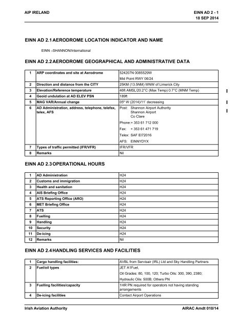
18 SEP 2014<br />
AIP IRELAND<br />
<strong>EINN</strong> AD 2 - 1<br />
18 SEP 2014<br />
<strong>EINN</strong> AD 2.1 AERODROME LOCATION INDICATOR AND NAME<br />
<strong>EINN</strong> –SHANNON/International<br />
<strong>EINN</strong> AD 2.2 AERODROME GEOGRAPHICAL AND ADMINISTRATIVE DATA<br />
1 ARP coordinates and site at Aerodrome 524207N 0085529W<br />
Mid Point RWY 06/24<br />
2 Direction and distance from the CITY 25KM (13.5NM) WNW of Limerick City<br />
3 Elevation/Reference temperature 46ft AMSL/20.2°C (Max Temp) 0.7°C (MNM Temp)<br />
4 Geoid undulation at AD ELEV PSN 189ft<br />
5 MAG VAR/Annual change 05º W (2014)/11’ decreasing<br />
6 AD Administration, address, telephone, telefax,<br />
telex, AFS<br />
Post:<br />
Shannon Airport <strong>Authority</strong><br />
Shannon Airport<br />
Co Clare<br />
Phone:+ 353 61 712 000<br />
Fax: + 353 61 471 719<br />
Telex: SAF EI72016<br />
AFS: <strong>EINN</strong>YDYX<br />
7 Types of traffic permitted (IFR/VFR) IFR/VFR<br />
8 Remarks Nil<br />
<strong>EINN</strong> AD 2.3 OPERATIONAL HOURS<br />
1 AD Administration H24<br />
2 Customs and immigration H24<br />
3 Health and sanitation H24<br />
4 AIS Briefing Office H24<br />
5 ATS Reporting Office (ARO) H24<br />
6 MET Briefing Office H24<br />
7 ATS H24<br />
8 Fuelling H24<br />
9 Handling H24<br />
10 Security H24<br />
11 De-icing H24<br />
12 Remarks Nil<br />
<strong>EINN</strong> AD 2.4 HANDLING SERVICES AND FACILITIES<br />
1 Cargo handling facilities: AVBL from Servisair (IRL) Ltd and Sky Handling Partners<br />
2 Fuel/oil types JET A1Fuel,<br />
Oil Grades: 80, 100, 120; Turbo Oils: 300, 390, 2380;<br />
Hydraulic Oils: 500B; Others PN<br />
3 Fuelling facilities/capacity 1HR PN required for operators not having standing<br />
arrangements<br />
4 De-icing facilities Contact Airport Operations<br />
<strong>Irish</strong> <strong>Aviation</strong> <strong>Authority</strong><br />
AIRAC Amdt 010/14
18 SEP 2014<br />
<strong>EINN</strong> AD 2 - 2<br />
18 SEP 2014<br />
AIP IRELAND<br />
5 Hangar space available for visiting aircraft Contact Airport Operations<br />
6 Repair facilities for visiting aircraft AVBL from Transaero Engineering Ireland, Shannon<br />
Aerospace, Eirtech, Signature, Aer Lingus, and Westair <strong>Aviation</strong><br />
7 Remarks Nil<br />
<strong>EINN</strong> AD 2.5 PASSENGER FACILITIES<br />
1 Hotels At Airport<br />
2 Restaurants 300 seats<br />
3 Transportation Buses, Taxis, Car Hire<br />
4 Medical facilities RFFS trained Cardiac and Emergency first responders, First Aid<br />
at Airport<br />
Hospitals – Limerick, Ennis<br />
Doctor on request, call out charge<br />
Cardiac ambulance available on request<br />
5 Bank and Post Office ATM’s and Bureau de Change at Airport<br />
Post Office, Shannon Town Centre – 2M<br />
6 Tourist Office At Airport<br />
7 Remarks Short term Car Parking - 310 spaces<br />
Long term Car Parking - 4900 spaces<br />
<strong>EINN</strong> AD 2.6 RESCUE AND FIRE FIGHTING SERVICES<br />
1 AD category for fire fighting Required CAT9<br />
Available CAT9<br />
2 Rescue equipment Equipment to meet ICAO requirements.<br />
3 Capability for removal of disabled aircraft 70,000kg capability on site. Additional equipment available from<br />
Dublin Airport.<br />
Contact the Coordinator<br />
Phone:+ 353 61 712 497<br />
4 Remarks Communication with Rescue and Fire Fighting Service<br />
Frequency 121.600MHz AVBL for direct communication<br />
between ACFT and Rescue and Fire Fighting Service.<br />
121.600MHz should be requested initially via ATC.<br />
Call sign for the Rescue and Fire Fighting Service is “Shannon<br />
Fire”.<br />
It is mandatory for both ACFT and Rescue and Fire Fighting<br />
Service to maintain contact with ATC at all times.<br />
ATC do not have access to 121.600MHz.<br />
Frequency 121.600MHz is H24 and is AVBL within 8NM radius<br />
of Shannon Airport.<br />
<strong>EINN</strong> AD 2.7 SEASONAL AVAILABILITY - CLEARING<br />
1 Type(s) of clearing equipment 2 De-icing Vehicles, 1 Sweeper<br />
2 Clearance priorities Contact Airport Operations<br />
3 Remarks Refer to Aerodrome Manual/Airport Operations<br />
Phone:+ 353 61 712 497<br />
AIRAC Amdt 010/14<br />
<strong>Irish</strong> <strong>Aviation</strong> <strong>Authority</strong>
18 SEP 2014<br />
AIP IRELAND<br />
<strong>EINN</strong> AD 2 - 3<br />
18 SEP 2014<br />
<strong>EINN</strong> AD 2.8 APRONS, TAXIWAYS AND CHECK LOCATION DATA<br />
1 Apron surface and strength West Apron Surface: CONC<br />
Strength: PCN 75/R/C/W/U<br />
East Apron Surface: CONC<br />
Strength: PCN 60/R/C/W/U<br />
East Parking Surface: CONC<br />
Area<br />
Strength: PCN 60/R/C/W/U<br />
Long Term Surface: CONC<br />
Parking Area<br />
Strength: PCN 60/R/C/W/U<br />
2 Taxiway width, surface and strength TAXIWAY WIDTH SURFACE STRENGTH<br />
A 23 M ASPH PCN75/R/C/W/U<br />
C 23 M ASPH PCN60/F/D/W/T<br />
D1 23 M ASPH PCN75/R/C/W/U<br />
D2 23 M ASPH PCN75/R/C/W/U<br />
E3 23 M CONC PCN60/R/C/W/U<br />
G 23 M CONC/ASPH PCN55/R/C/W/T<br />
H1 23 M CONC PCN17/R/D/W/U<br />
H2 23 M CONC PCN17/R/D/W/U<br />
3 Altimeter checkpoint location and elevation Location: Terminal Apron / Elevation: 9ft AMSL<br />
4 VOR checkpoint Nil<br />
5 INS checkpoint <strong>EINN</strong> AD 2.24-2<br />
6 Remarks Nil<br />
<strong>EINN</strong> AD 2.9 SURFACE MOVEMENT GUIDANCE AND CONTROL SYSTEM AND<br />
MARKINGS<br />
1 Use of aircraft stand ID signs, TWY guide lines<br />
and visual docking/parking guidance system of<br />
aircraft stands<br />
Taxiing guidance signs at all intersections and at all holding<br />
points<br />
Mandatory signs lighted.<br />
AGNIS at stands 30, 32, 34 and 37.<br />
Guidelines on aprons and taxiways.<br />
Taxiway information markings.<br />
Marshalling at aircraft stands.<br />
2 RWY/TWY markings and LGT RWY 06/24<br />
Designation THR, TDZ, centreline, edge, aiming point,<br />
Displaced Threshold RWY 24.<br />
TWY<br />
Centreline, Edge, Holding Positions, Intersection Markings<br />
APRON<br />
Stand lead-in lines and markings, Wing-tip clearance lines<br />
3 Stop bars Controllable stopbar on TWY D2<br />
Fixed stopbars on TWY A, TWY C, TWY G, disused RWY 13,<br />
disused RWY 09<br />
Runway guard lights configuration A on TWY C and TWY D2<br />
Intermediate holding position lights on TWY A<br />
Intermediate holding position lights on TWY D2<br />
4 Remarks See also <strong>EINN</strong> 2.14 and <strong>EINN</strong> 2.15 for lighting<br />
<strong>Irish</strong> <strong>Aviation</strong> <strong>Authority</strong><br />
AIRAC Amdt 010/14
18 SEP 2014<br />
<strong>EINN</strong> AD 2 - 4<br />
18 SEP 2014<br />
AIP IRELAND<br />
<strong>EINN</strong> AD 2.10AERODROME OBSTACLES<br />
RWY/Area<br />
affected<br />
In approach/TKOF areas In circling area and at AD Remarks<br />
1 2 3<br />
Obstacle type<br />
Elevation<br />
Markings/LGT<br />
Coordinates<br />
Obstacle type<br />
Elevation<br />
Markings/LGT<br />
Coordinates<br />
a b c a b<br />
06/APCH<br />
24/TKOF<br />
24/APCH<br />
06/TKOF<br />
Tree<br />
28.5M/94ft<br />
Nil<br />
DVOR/DME<br />
39.5M/130ft<br />
LGTD<br />
524121.8N<br />
0085720.24W<br />
524315.64N<br />
0085306.77W<br />
Tree<br />
53.5M/176ft<br />
Nil<br />
Mast<br />
71.5M/235ft<br />
LGTD<br />
Pole<br />
75.5M/248ft<br />
Nil<br />
Tree<br />
103.0M/338ft<br />
Nil<br />
Tree<br />
68.0M/223ft<br />
Nil<br />
Tree<br />
69.0M/227ft<br />
Nil<br />
Mast<br />
72.0M/236ft<br />
LGTD<br />
Glide Path 24<br />
21.5M/71ft<br />
Nil<br />
Glide Path 06<br />
31.5M/103ft<br />
Nil<br />
Mast<br />
331.0M/1086ft<br />
LGTD<br />
Mast<br />
329.0M/1078ft<br />
LGTD<br />
Mast<br />
307.0M/1006ft<br />
LGTD<br />
Mast<br />
311.5M/1021ft<br />
Nil<br />
524346.99N<br />
0085438.93W<br />
524436.86N<br />
0085538.80W<br />
524219.36N<br />
0084906.26W<br />
524202.81N<br />
0090457.85W<br />
524443.36N<br />
0085338.48W<br />
524430.78N<br />
0085259.60W<br />
524434.86N<br />
0085538.80W<br />
524232.13N<br />
0085447.67W<br />
524147.22N<br />
0085623.10W<br />
524339.24N<br />
0084222.21W<br />
524327.74N<br />
0084236.49W<br />
524326.12N<br />
0084308.63W<br />
523747.54N<br />
0082721.29W<br />
<strong>EINN</strong> AD 2.11METEOROLOGICAL INFORMATION PROVIDED<br />
1 Associated MET Office Shannon Airport<br />
2 Hours of service H24<br />
3 Office responsible for TAF preparation Met Eireann Central <strong>Aviation</strong> Office, Shannon.<br />
Periods of validity<br />
Interval of issuance.<br />
24 HR<br />
6 HR respectively<br />
AIRAC Amdt 010/14<br />
<strong>Irish</strong> <strong>Aviation</strong> <strong>Authority</strong>
18 SEP 2014<br />
AIP IRELAND<br />
<strong>EINN</strong> AD 2 - 5<br />
18 SEP 2014<br />
4 Type of landing forecast<br />
Interval of issuance.<br />
METAR, TREND.<br />
30 Minutes.<br />
5 Briefing/consultation provided Internet-based self-briefing facility.<br />
Personal briefing by telephone from Central <strong>Aviation</strong> Office,<br />
Shannon<br />
6 Flight documentation<br />
Language(s) used<br />
Charts and Tabular<br />
English<br />
7 Charts and other information available for<br />
briefing or consultation<br />
6-hourly Synoptic Chart;<br />
6-hourly prognostic chart (surface);<br />
Prognostic chart of significant weather;<br />
Prognostic chart of wind/temperature at upper levels;<br />
Prognostic chart of tropopause levels.<br />
8 Supplementary equipment available for<br />
providing information<br />
<strong>EINN</strong> AD 2.12RUNWAY PHYSICAL CHARACTERISTICS<br />
Weather surveillance radar<br />
IRVR RWY 06 and 24 – touchdown, midpoint, stopend<br />
9 ATS units provided with information EISN FIX/ACC<br />
Shannon TWR<br />
10 Additional information (limitation of service, etc.) Refer to AIC 16/97 and GEN 3.5.4.2 to request additional<br />
information.<br />
DesignationsR<br />
WYNR<br />
TRUE BRG<br />
Dimensions of<br />
RWY<br />
Strength (PCN)<br />
and surface of<br />
RWY and SWY<br />
THR coordinates<br />
RWY end<br />
coordinates THR<br />
geoid undulation<br />
THR elevation<br />
and highest<br />
elevation of TDZ<br />
of precision APP<br />
RWY<br />
1 2 3 4 5 6<br />
06 052.22º 3199M x 45M 75 R/C/W/U<br />
ASPH<br />
24 232.25º 3199M x 45M 75 R/C/W/U<br />
ASPH<br />
524135.42N<br />
0085636.67W<br />
524238.80N<br />
0085421.98W<br />
189ft<br />
524236.03N<br />
0085427.87W<br />
524135.42N<br />
0085636.67W<br />
189ft<br />
THR 46ft<br />
THR 15ft<br />
Slope of RWY-<br />
SWY<br />
SWY<br />
dimensions<br />
CWY<br />
dimensions<br />
Strip<br />
dimensions<br />
OFZ<br />
Remarks<br />
7 8 9 10 11 12<br />
Refer to<br />
Aerodrome<br />
Obstruction<br />
Chart Type A<br />
Nil<br />
Nil<br />
61M x 150M<br />
61M x 150M<br />
3321M x 300M<br />
3321M x 300M<br />
ASPH overlay on RWY 06/24<br />
commences 20m from THR RWY 06<br />
and extends for full length of runway.<br />
RWY 06/24 has 8m wide shoulders.<br />
<strong>Irish</strong> <strong>Aviation</strong> <strong>Authority</strong><br />
AIRAC Amdt 010/14
18 SEP 2014<br />
<strong>EINN</strong> AD 2 - 6<br />
18 SEP 2014<br />
AIP IRELAND<br />
<strong>EINN</strong> AD 2.13DECLARED DISTANCES<br />
RWY Designator TORA TODA ASDA LDA Remarks<br />
1 2 3 4 5 6<br />
06 3199 M 3260 M 3199 M 3199 M<br />
24 3199 M 3260 M 3199 M 3059 M<br />
Nil<br />
INTERSECTION TAKE-OFF<br />
RWY Designator TWY TORA TODA ASDA Remarks<br />
06 A 2067 M 2128 M 2067 M<br />
24 C 2703 M 2764 M 2703 M<br />
24 D2 3046 M 3107 M 3046 M<br />
see <strong>EINN</strong> 2.20<br />
<strong>EINN</strong> AD 2.14APPROACH AND RUNWAY LIGHTING<br />
RWY<br />
Designator<br />
APCH LGT<br />
type<br />
LEN INTST<br />
THR LGT<br />
colour<br />
WBAR<br />
VASIS<br />
(MEHT)<br />
PAPI<br />
TDZ<br />
Length<br />
RWY Centre<br />
Line LGT<br />
Length,<br />
spacing,<br />
colour, INTST<br />
RWY edge<br />
LGT LEN,<br />
spacing,<br />
colour,<br />
INTST<br />
RWY End<br />
LGT<br />
colour<br />
WBAR<br />
SWY<br />
LGT<br />
LEN (M)<br />
colour<br />
Remarks<br />
1 2 3 4 5 6 7 8 9 10<br />
06 SALS<br />
470M<br />
LIH<br />
24 CAT II<br />
900M<br />
LIH<br />
Green<br />
LIH<br />
-<br />
Displaced<br />
Green<br />
LIH<br />
Green<br />
LIH<br />
PAPI Both<br />
sides/3º<br />
MEHT<br />
20.6M<br />
(545M)<br />
PAPI Both<br />
sides/3º<br />
MEHT<br />
22.6M<br />
(463M)<br />
Nil<br />
900M<br />
30M<br />
LIH<br />
3200M<br />
15M coded<br />
02300M White,<br />
2300-2900M<br />
Red/White,<br />
2900-3200M<br />
Red LIH<br />
3060M<br />
15M coded 0-<br />
2160M White,<br />
2160-2760M<br />
Red/White,<br />
2760-3060M<br />
Red LIH<br />
3200M<br />
60M nom<br />
White (last<br />
600M<br />
Yellow)<br />
LIH<br />
3060M<br />
60M nom<br />
White (last<br />
600M<br />
Yellow)<br />
RWY edge<br />
lights on<br />
APCH side<br />
of displaced<br />
THR 24<br />
coded Red<br />
for 140M<br />
Red<br />
LIH<br />
-<br />
Red<br />
LIH<br />
-<br />
Nil<br />
Nil<br />
Nil<br />
Nil<br />
<strong>EINN</strong> AD 2.15OTHER LIGHTING, SECONDARY POWER SUPPLY<br />
1 ABN/IBN location, characteristics and hours of<br />
operation<br />
ABN on Tower Flashing White/Green, 24 flashes per min<br />
2 LDI location and LGT<br />
Anemometer location and LGT<br />
Nil<br />
2 Nr. Adjacent TWY C and south of TWR<br />
3 TWY edge and centre line lighting Edge blue all TWY’s except TWY’s C, G and H2<br />
Edge blue retroreflective markers TWY’s C, G and H2 and blue<br />
lights at intersection with RWY 06/24<br />
Coloured coded centreline lights on TWY’s A, D1 and D2<br />
AIRAC Amdt 010/14<br />
<strong>Irish</strong> <strong>Aviation</strong> <strong>Authority</strong>
18 SEP 2014<br />
AIP IRELAND<br />
<strong>EINN</strong> AD 2 - 7<br />
18 SEP 2014<br />
4 Secondary power supply/switch-over time Secondary power supply provided, switch-over time 15 SEC (1<br />
SEC in Low Visibility Procedures)<br />
Electric battery lamps<br />
5 Remarks Apron: Floodlighting<br />
Apron edge: Blue omni- directional, elevated and inset<br />
Obstacles: Fixed Red<br />
WDIs 4Nr, (1 lighted). See Aerodrome Chart <strong>EINN</strong> AD 2.24-1<br />
<strong>EINN</strong> AD 2.16HELICOPTER LANDING AREA<br />
Nil<br />
<strong>EINN</strong> AD 2.17ATS AIRSPACE<br />
1 Designation and lateral limits Shannon Control Zone<br />
Circle, Radius 15NM 524207N 0085529W (Shannon ARP)<br />
(See Remarks)<br />
2 Vertical limits 5000ft AMSL<br />
3 Airspace classification C<br />
(See Remarks)<br />
4 ATS unit call sign Language(s) Shannon Tower<br />
English<br />
5 Transition altitude 5000ft<br />
6 Remarks The following airspace within the Shannon Control Zone is<br />
uncontrolled<br />
• Circle, radius 1.5 NM 523958N 0084053W, SFC to<br />
1000ft AMSL.<br />
• Area within bearings from 045º True BRG clockwise to<br />
180ºTrue BRG from 523958N 0084053W to INT with<br />
boundary<br />
<strong>EINN</strong> AD 2.18ATS COMMUNICATIONS FACILITIES<br />
Service designation Call sign Frequency Hours of Operation Remarks<br />
1 2 3 4 4<br />
GND Shannon Ground 121.800 MHz 1000-1600 Local Time Nil<br />
TWR Shannon Tower 118.700 MHz H24 Nil<br />
121.800 MHz<br />
APP Shannon Approach 121.400 MHz H24 Nil<br />
120.200 MHz<br />
APP (RADAR) Shannon Approach 121.400 MHz H24 Nil<br />
RADAR<br />
ATIS Shannon Information 130.950 MHz H24 Nil<br />
D-ATIS Shannon Information H24 Operators equipped with AEEC623<br />
compliant ACARS-MU can interface<br />
with the service through ARINC and<br />
SITA service provider’s network.<br />
<strong>Irish</strong> <strong>Aviation</strong> <strong>Authority</strong><br />
AIRAC Amdt 010/14
18 SEP 2014<br />
<strong>EINN</strong> AD 2 - 8<br />
18 SEP 2014<br />
AIP IRELAND<br />
<strong>EINN</strong> AD 2.19RADIO NAVIGATION AND LANDING AIDS<br />
Type of aid,<br />
MAG VAR,<br />
Type of<br />
supported OP<br />
(for VOR/ILS/<br />
MLS, give<br />
declination)<br />
ID Frequency Hours of<br />
operation<br />
Position of<br />
transmitting<br />
antenna<br />
coordinates<br />
Elevation of<br />
DME<br />
transmitting<br />
antenna<br />
Remarks<br />
1 2 3 4 5 6 7<br />
DVOR/DME<br />
5ºW 2014<br />
SHA 113.300 MHz H24 524315.6N<br />
0085306.8W<br />
NDB ENS 352 kHz H24 525418.6N<br />
0085540.0W<br />
NDB FOY 395 kHz H24 523358.5N<br />
0091143.5W<br />
ILS LLZ RWY 06 ISE 109.5 MHz H24 524245.3N<br />
0085408.2W<br />
ILS GP RWY 06 332.6MHz H24 524147.2N<br />
0085623.1W<br />
ILS DME RWY<br />
06<br />
ISE<br />
CH32X<br />
(109.5 MHz)<br />
H24 524147.2N<br />
0085623.1W<br />
ILS LLZ RWY 24 ISW 110.95MHz H24 524129.4N<br />
0085649.6W*<br />
ILS GP RWY 24 330.65MHz H24 524232.1N<br />
0085447.7W<br />
LO RWY 24 OL 339 kHz H24 524456.4N<br />
0084926.0W<br />
OM RWY 24<br />
MM RWY 24<br />
ILS DME RWY<br />
24<br />
2 Dashes<br />
per sec<br />
Dots and<br />
Dashes<br />
ISW<br />
75 MHz H24 524455.5N<br />
0084927.0W<br />
75 MHz H24 524254.8N<br />
0085347.9W<br />
CH46Y<br />
(110.95 MHz)<br />
H24 524232.1N<br />
0085447.7W<br />
200ft Designated Operational Coverage 300<br />
NM/70,000ft 180ºTrue BRG to 360º<br />
True BRG.<br />
Designated Operational Coverage 100<br />
NM/50,000ft.<br />
100ft<br />
100ft<br />
Designated Operational Coverage 40<br />
NM<br />
Designated Operational Coverage 50<br />
NM<br />
Coverage restricted to 35º either side of<br />
course line. Signals received outside<br />
coverage sector, (including back beam<br />
radiation), should be ignored.<br />
GP Angle 3º<br />
RDH 55ft<br />
Full scale fly down indication may not<br />
be maintained when above GP sector.<br />
Full scale fly up indication may not be<br />
maintained when left of LLZ sector and<br />
below GP.<br />
DME Zero ranged to THR 06. DME<br />
zero range is displaced from DME<br />
antenna by 445M.<br />
Coverage restricted to 35° either side of<br />
the course line. Signals received<br />
outside coverage sector, (including<br />
back beam radiation), should be<br />
ignored.<br />
No LLZ coverage below 3000ft MSL AT<br />
25 NM <strong>EINN</strong><br />
*Data whose accuracy has not been<br />
quality assured.<br />
GP Angle 3° RDH 59ft<br />
Designated Operational Coverage<br />
15NM<br />
DME Zero ranged to THR 24. DME<br />
zero range is displaced from DME<br />
antenna by 391M.<br />
<strong>EINN</strong> AD 2.20 LOCAL TRAFFIC REGULATIONS<br />
1. Taxiing Restrictions<br />
180º turns executed by wide-bodied aircraft on RWY 06/24 are permitted only at runway ends.<br />
AIRAC Amdt 010/14<br />
<strong>Irish</strong> <strong>Aviation</strong> <strong>Authority</strong>
18 SEP 2014<br />
AIP IRELAND<br />
<strong>EINN</strong> AD 2 - 9<br />
18 SEP 2014<br />
Aircraft using the turn pads should follow the marked taxiing guidance lines and use the minimum speed necessary<br />
to complete the turning manoeuvre.<br />
2. Marshalling Services<br />
Marshalling Service is mandatory for all arriving aircraft intending to park on either the West, Central or East Aprons.<br />
Marshalling Service is otherwise available on request from the Airport Operations Office<br />
Phone:+ 353 61 712 240<br />
or<br />
Phone:+ 353 61 712 241<br />
Use of the Marshalling Service does not imply the necessity to avail of full handling services.<br />
3. Availability of Intersection Take-Offs<br />
3.1 Take-offs using less than the full length of the runway are available from TWY/RWY intersections as listed in <strong>EINN</strong><br />
AD 2.13 DECLARED DISTANCES<br />
The datum from which the reduced declared distances on Runway 06/24 are measured is the intersection of the<br />
extended downwind edge of the specific taxiway with the runway edge, projected perpendicular to the runway<br />
centreline.<br />
3.2 The take-off run available (TORA) is displayed on an illuminated sign adjacent to the taxiway.<br />
3.3 Intersection take-offs are subject at all times to pilots’ discretion and aircraft operational requirements. Pilots should<br />
advise as early as possible of their ability to accept intersection takeoffs.<br />
3.4 Approval for intersection take-offs is subject to the air traffic situation.<br />
<strong>EINN</strong> AD 2.21NOISE ABATEMENT PROCEDURES<br />
Aircraft operators shall ensure, at all times that aircraft are operated in a manner calculated to cause the least<br />
disturbance practicable in areas surrounding the airport.<br />
<strong>EINN</strong> AD 2.22FLIGHT PROCEDURES<br />
1. Holding areas<br />
Protected airspace is provided for Holding Areas in accordance with the criteria contained in PANS –OPS ICAO Doc<br />
8168, Volume II to facilitate navigation using VOR, NDB and DME navigation aids.<br />
2. SIDs and STARs<br />
2.1 RNAV Equipped Aircraft<br />
SIDs and STARs for RWY24 and RWY06 have been developed in accordance with ICAO Doc 8168 (PANS OPS)<br />
and comply with Eurocontrol guidelines for the design of Terminal Procedures for Area Navigation.<br />
The supporting navigation infrastructure includes the choice of DME/DME, GNSS, VOR/DME (for reversionary<br />
navigation purposes) and INS/IRS as permitted by the Aircraft Flight Manual (AFM) and/or approved by the<br />
appropriate regulatory authority.<br />
Use of DME/DME may not be available below about 6000ft where terrain may obstruct line of sight with the DME<br />
infrastructure.<br />
Operators which have obtained operational and airworthiness approval, from their regulatory authority, may operate<br />
the RNAV SID and STAR procedures in accordance with the conditions of approval including<br />
• P-RNAV certificated aircraft;<br />
• B-RNAV certificated aircraft only above MSA;<br />
Climb to MSA on the initial segments of the RNAV SIDs may be conducted using conventional navigation.<br />
If the RNAV equipment fails, or navigation accuracy of +1 NM can not be maintained, inform ATC as soon as<br />
possible. Radar vectoring will be provided.<br />
<strong>Irish</strong> <strong>Aviation</strong> <strong>Authority</strong><br />
AIRAC Amdt 010/14
18 SEP 2014<br />
<strong>EINN</strong> AD 2 - 10<br />
18 SEP 2014<br />
AIP IRELAND<br />
2.2 RTF Phraseology<br />
Phraseology used will be as provided in the European Regional Supplementary Procedures (ICAO Doc 7030) and<br />
outlined in Eurocontrol Guidance material for RNAV SIDs and STARs.<br />
Examples of phraseology for ATC are:<br />
{CALLSIGN} CLEARED {STAR designator} ARRIVAL, RUNWAY {designator}.<br />
Note: On such a clearance flight crew shall continue on route until reaching start point of the STAR.<br />
{CALLSIGN} ADVISE IF ABLE {designator} DEPARTURE [or ARRIVAL].<br />
If ATC are unable to issue a requested SID or STAR:<br />
{CALLSIGN} UNABLE TO ISSUE (designator) DEPARTURE [or ARRIVAL] DUE [Reason]<br />
Examples of pilot phraseology in the event of being unable to accept SID or STAR<br />
UNABLE (designator) DEPARTURE [or ARRIVAL] DUE TO RNAV TYPE.<br />
UNABLE RNAV DUE EQUIPMENT<br />
2.3 Non RNAV Equipped aircraft<br />
Non RNAV equipped aircraft will be assigned a departure clearance based on the omni directional procedures<br />
referenced in <strong>EINN</strong> AD 2.22.7.<br />
3. Waypoint Listing<br />
Waypoint<br />
E = En-route<br />
T = Terminal<br />
Latitude Longitude Comment<br />
ABAGU E,T See ENR 4.4 See ENR 4.4<br />
ADARU T 52 35 37.8N 008 55 51.4W<br />
AGINI E,T See ENR 4.4 See ENR 4.4<br />
ASGON T 52 35 54.4N 009 08 38.1W<br />
BEVES T 52 39 34.5N 009 00 53.2W<br />
BUNON E,T See ENR 4.4 See ENR 4.4<br />
DERAG T 52 51 46.6N 008 34 49.4W<br />
DIGAN E,T See ENR 4.4 See ENR 4.4<br />
DISUR T 52 43 31.0N 009 05 55.8W<br />
ELPOM T 52 33 37.1N 009 13 26.8W<br />
ERABI E,T See ENR 4.4 See ENR 4.4<br />
GATLO T 52 40 58.3N 008 44 26.6W<br />
GILOG T 52 46 10.0N 008 25 26.2W<br />
GORTO T 52 57 19.0N 008 57 32.7W<br />
GULTU T 52 48 35.8N 009 23 17.5W<br />
KURUM E,T See ENR 4.4 See ENR 4.4<br />
LUNIG E,T See ENR 4.4 See ENR 4.4<br />
LUPOR E,T See ENR 4.4 See ENR 4.4<br />
MOMIN E,T See ENR 4.4 See ENR 4.4<br />
NEPOG T 52 48 54.2N 008 54 26.4W<br />
OGONO T 52 55 25.1N 008 26 57.5W<br />
OSGAR E,T See ENR 4.4 See ENR 4.4<br />
AIRAC Amdt 010/14<br />
<strong>Irish</strong> <strong>Aviation</strong> <strong>Authority</strong>
18 SEP 2014<br />
AIP IRELAND<br />
<strong>EINN</strong> AD 2 - 11<br />
18 SEP 2014<br />
Waypoint<br />
E = En-route<br />
T = Terminal<br />
Latitude Longitude Comment<br />
PELIG E,T See ENR 4.4 See ENR 4.4<br />
RERKA T 52 28 06.4N 009 06 24.0W<br />
RIKUL E,T See ENR 4.4 See ENR 4.4<br />
ROSRO T 52 48 19.1N 008 42 15.4W<br />
TERDU T 52 39 07.4N 009 20 31.4W<br />
TIPUR E,T See ENR 4.4 See ENR 4.4<br />
TOBRI T 52 57 17.2N 008 41 49.6W<br />
TOMTO E,T See ENR 4.4 See ENR 4.4<br />
ULSIT T 52 52 10.0N 008 52 55.0W<br />
UNBEG E,T See ENR 4.4 See ENR 4.4<br />
4. Visual Manoeuvring Approaches<br />
Visual manoeuvring (circling) approaches are permissible, on request, to all runways.<br />
5. Speed Control – General Provisions<br />
Speed Restrictions<br />
General<br />
Routeing to<br />
Holds<br />
Initial<br />
Segment<br />
Final Approach<br />
REMARKS<br />
Below FL100,<br />
Max IAS<br />
250KT<br />
At DERAG<br />
and ELPOM,<br />
Max IAS<br />
220KT<br />
Max IAS<br />
210KT<br />
Recommended<br />
IAS 160 KT from<br />
FAF to OM<br />
1. ATC may request specific speeds for<br />
accurate spacing. Comply with speed<br />
adjustments as promptly as feasible within<br />
operational constraints.<br />
2. If unable to comply with the above, advise<br />
ATC as soon as possible<br />
6. Arrival Procedures<br />
6.1 Clearance to enter the CTA and CTR<br />
Aircraft flying the ATS Route system will be cleared into the CTA/CTR without having to request a specific entry<br />
clearance.<br />
Arriving Aircraft capable of flying STARs will normally be cleared on a STAR appropriate to the route by ATC. On<br />
occasions ATC may radar vector aircraft for arrival (Due traffic or technical reasons).<br />
Standard Arrivals Routes used in the Shannon CTA are based on Holding Patterns at DERAG and ELPOM.<br />
6.2 Initial Approach Procedures.<br />
6.2.1 With Radar Control<br />
In order to expedite the flow of traffic, aircraft may be cleared on STARs, or may receive radar vectors on to final<br />
approach track from the hold or earlier on the Standard Arrival Route.<br />
Pilots should plan their flight profile in such a manner as to be able to achieve the Minimum Holding Level at the<br />
appropriate hold.<br />
Actual descent clearance will be as directed by ATC.<br />
6.2.2 Without Radar Control.<br />
When RADAR is not serviceable, aircraft will be cleared to join the instrument approach procedure appropriate to<br />
the landing direction from the appropriate hold.<br />
<strong>Irish</strong> <strong>Aviation</strong> <strong>Authority</strong><br />
AIRAC Amdt 010/14
18 SEP 2014<br />
<strong>EINN</strong> AD 2 - 12<br />
18 SEP 2014<br />
AIP IRELAND<br />
6.2.3 Communications failure procedures for arriving aircraft.<br />
Aircraft experiencing communications failure in the Shannon CTR/CTA shall set transponder code A7600 and<br />
comply with standard ICAO procedures.<br />
Supplemented by the following:<br />
Traffic cleared on STAR<br />
Aircraft cleared on a STAR and experiencing a Communications failure shall follow the route of the STAR at the last<br />
cleared level or altitude. On reaching the appropriate hold fix, descend to 3000ft and complete the instrument<br />
approach procedure appropriate to the Runway in use.<br />
Traffic Radar vectored to final approach<br />
Aircraft being radar vectored to final approach should join, in the most expeditious manner, and complete the<br />
Instrument Approach procedure appropriate to the Runway in use.<br />
If unable to comply with above, or uncertain of position, climb to 3000ft QNH, proceed in the most expeditious<br />
manner to the hold appropriate to the Runway in use and complete the Instrument Approach Procedure appropriate<br />
to the Runway in Use<br />
7. Departure Procedures<br />
7.1 RWY’s 06 and 24<br />
Aircraft capable of complying with Standard Instrument Departures will proceed in accordance with the SID.<br />
If an aircraft is unable to comply with Standard Instrument Departure the phraseology “Unable to comply with<br />
{departure} due {reasons}”<br />
Pilots who cannot comply with Standard Instrument Departures shall advise ATC in good time using the phraseology<br />
“Unable to comply with {departure} due {reasons}, so that alternative clearances can be issued.<br />
7.2 RWY’s 06 and 24 -Omnidirectional departures<br />
Pilots who cannot comply with any of the Omnidirectional Departure procedures must inform ATC in good time so<br />
that alternative clearances can be issued.<br />
Note: CAT A, B aircraft may be assigned an Omnidirectional Departure appropriate to CAT C, D aircraft at the<br />
discretion of ATC<br />
7.3 Communications failure procedures for departing aircraft.<br />
Aircraft experiencing communications failure in Shannon CTA/CTR shall set transponder code A7600 and comply<br />
with the following procedures:<br />
RFL below FL080: Departing traffic cleared by ATC to a level/altitude below the RFL, shall comply with<br />
Communication failure procedures as outlined in ICAO Annex 2.<br />
RFL FL080 or above: Departing traffic cleared by ATC to a level or altitude below FL080 shall maintain the cleared<br />
level for a period of three minutes following the time the altitude/level is reached and thereafter adjust level and<br />
speed in accordance with filed flight plan.<br />
Departing Traffic experiencing a communications failure above FL080 shall comply with communications failure<br />
procedures as outlined in ICAO Annex 2<br />
8. Low Visibility Procedures<br />
8.1 Low Visibility Procedures apply when the cloud ceiling is below 200ft (60M) and/or the IRVR is less than 550M.<br />
8.2 Only RWY 24 may be used for CAT II operations. The CAT II holding position on TWY D2 must be used.<br />
8.3 When these procedures are in operation and RWY 24 is in use the following standard taxi route system applies:<br />
• Departing aircraft shall normally use TWY’s D1 and D2.<br />
• Arriving aircraft shall normally use TWY A.<br />
AIRAC Amdt 010/14<br />
<strong>Irish</strong> <strong>Aviation</strong> <strong>Authority</strong>
18 SEP 2014<br />
AIP IRELAND<br />
<strong>EINN</strong> AD 2 - 13<br />
18 SEP 2014<br />
8.4 TWY/Stopbar/Centreline lighting/lead on/lead off will be in use.<br />
8.5 At no time shall an aircraft or vehicle cross an illuminated stop bar and any instruction to do so should be challenged.<br />
In exceptional circumstances when the stop bar cannot be extinguished the authorisation to cross the illuminated<br />
stop bar may be given by ATS. This shall always be challenged and confirmation received that this instruction is part<br />
of a contingency arrangement due to a failure of the stop bar. All aircraft and vehicles operators shall request for the<br />
instruction to cross an illuminated stop bar to be reconfirmed by ATS and read back before proceeding.<br />
8.6 Pilots will be informed by AFIS broadcast or RTF when Low Visibility Procedures are in operation<br />
8.7 Full details of Low Visibility Procedures are available on request from Aerodrome Administration<br />
(see <strong>EINN</strong> AD 2.2.5)<br />
9. Holding Procedures<br />
REVISED HOLDING PROCEDURES<br />
A standard rate of descent of 500ft per min in holding patterns will be used unless otherwise instructed by ATC.<br />
All turns are to be made at a bank angle of 25° or a rate of 3° per second, whichever requires the lesser bank<br />
Holding Point LOC Co-ordinates MAG Track<br />
Inbound<br />
Dir of Turn Limiting<br />
Outbound<br />
Direction<br />
MNM<br />
Holding Level<br />
MAX<br />
DERAG<br />
ELPOM<br />
FOYNES<br />
(FOY)<br />
(Contingency)<br />
ENNIS (ENS)<br />
(Contingency)<br />
See STAR<br />
Chart RWY 24<br />
See STAR<br />
Chart RWY 06<br />
See STAR<br />
Chart RWY 24<br />
SEE <strong>EINN</strong> AD<br />
2-19<br />
238º Right Hand 19D SHA 3000 FL140<br />
058° Left Hand 20D SHA 3000 FL140<br />
050° Left Hand 3000 FL140<br />
076° Left Hand 3500<br />
Holding Point Outbound Time Max IAS<br />
(Racetrack Decent on IAP)<br />
REMARKS<br />
At or<br />
Below<br />
FL140<br />
Above<br />
FL140<br />
Below<br />
FL060<br />
FL060-<br />
FL140<br />
Above<br />
FL140<br />
DERAG 220KT 220KT Rate 1 Turn<br />
ELPOM ELPOM ELPOM 220KT 220KT 220KT Rate 1 Turn<br />
FOYNES<br />
(FOY)<br />
(Contingency)<br />
1 Min 220KT 220KT Rate 1 Turn<br />
FOY Hold is an alternative Hold<br />
for use at the discretion of ATC.<br />
ENNIS (ENS)<br />
(Contingency)<br />
1 Min<br />
(after<br />
below<br />
14,000ft)<br />
220KT 220KT Rate 1 Turn<br />
ENS Hold is an alternative hold<br />
for use at the discretion of ATC<br />
<strong>Irish</strong> <strong>Aviation</strong> <strong>Authority</strong><br />
AIRAC Amdt 010/14
18 SEP 2014<br />
<strong>EINN</strong> AD 2 - 14<br />
18 SEP 2014<br />
AIP IRELAND<br />
10. SHANNON OMNIDIRECTIONAL DEPARTURES<br />
10.1 Aircraft Categories CAT A, B (Non Jet)<br />
RWY TRACK Aircraft<br />
Category<br />
Minimum Climb Gradient<br />
Routing<br />
24<br />
06<br />
238º<br />
058º<br />
A,B<br />
A,B<br />
Climb Gradient of 4.5% for airspace<br />
(275ft/NM)<br />
Climb Gradient of 3.3% for Obstacle<br />
Clearance<br />
Climb straight ahead until passing<br />
500ft QNH and then as directed by<br />
ATC.<br />
GND Speed KT 120 140 160<br />
275ft/NM 550 640 730<br />
10.2 Aircraft Categories CAT C,D (Jet)<br />
RWY TRACK Aircraft<br />
Category<br />
Minimum Climb Gradient<br />
Routing<br />
24 238º C,D Climb Gradient of 9.1% for airspace<br />
(550ft/NM)<br />
Climb Gradient of 3.3% for Obstacle<br />
Clearance<br />
Climb straight ahead until passing<br />
1800ft QNH and then as directed by<br />
ATC.<br />
06 058º Climb straight ahead until passing<br />
2000ft QNH and then as directed by<br />
ATC.<br />
GND Speed KT 150 200 250<br />
275ft/NM 1375 1835 2290<br />
<strong>EINN</strong> AD 2.23ADDITIONAL INFORMATION<br />
Refer to ENR 5.6 for bird hazard information.<br />
<strong>EINN</strong> AD 2.24CHARTS RELATED TO AERODROME<br />
Name<br />
Page<br />
Aerodrome Chart – ICAO <strong>EINN</strong> AD 2.24-1<br />
Aircraft Parking/Docking Chart – ICAO <strong>EINN</strong> AD 2.24-2<br />
Aerodrome Obstacle Chart RWY 06/24 – ICAO TYPE A <strong>EINN</strong> AD 2.24-4<br />
Precision Approach Terrain Chart RWY 24 – ICAO <strong>EINN</strong> AD 2.24-5<br />
RNAV Standard Departure Chart RWY 24 – ICAO<br />
RNAV Standard Departure Chart RWY 06 – ICAO<br />
RNAV Standard Terminal Arrival Chart RWY 24 – ICAO<br />
RNAV Standard Terminal Arrival Chart RWY 06 – ICAO<br />
<strong>EINN</strong> AD 2.24-7A<br />
<strong>EINN</strong> AD 2.24-8A<br />
<strong>EINN</strong> AD 2.24-9A<br />
<strong>EINN</strong> AD 2.24-10A<br />
Instrument Approach Chart ILS CAT I & II or LLZ RWY 24 <strong>EINN</strong> AD 2.24-11<br />
Instrument Approach Chart ILS or LLZ RWY 06 – ICAO <strong>EINN</strong> AD 2.24-12<br />
Instrument Approach Chart VOR RWY 24 – ICAO <strong>EINN</strong> AD 2.24-13<br />
AIRAC Amdt 010/14<br />
<strong>Irish</strong> <strong>Aviation</strong> <strong>Authority</strong>
18 SEP 2014<br />
AIP IRELAND<br />
<strong>EINN</strong> AD 2 - 15<br />
18 SEP 2014<br />
Name<br />
Page<br />
Instrument Approach Chart VOR RWY 06 – ICAO <strong>EINN</strong> AD 2.24-14<br />
Visual Approach Chart – ICAO <strong>EINN</strong> AD 2.24-15<br />
<strong>Irish</strong> <strong>Aviation</strong> <strong>Authority</strong><br />
AIRAC Amdt 010/14
18 SEP 2014<br />
<strong>EINN</strong> AD 2 - 16<br />
18 SEP 2014<br />
AIP IRELAND<br />
THIS PAGE INTENTIONALLY LEFT BLANK<br />
AIRAC Amdt 010/14<br />
<strong>Irish</strong> <strong>Aviation</strong> <strong>Authority</strong>