Lower Sabine Watershed Discovery Report - RiskMAP6
Lower Sabine Watershed Discovery Report - RiskMAP6
Lower Sabine Watershed Discovery Report - RiskMAP6

Create successful ePaper yourself
Turn your PDF publications into a flip-book with our unique Google optimized e-Paper software.
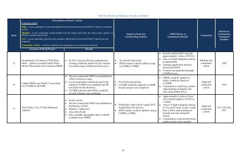
Table 21: Metrics and Rankings of Needs (continued)<br />
Evaluation Guide<br />
Description of Need / Action<br />
Item<br />
High – Local community would immediately benefit from the action and FEMA’s metrics would also<br />
be met<br />
Medium – Local community would benefit over the longer term from the action and a portion of<br />
FEMA’s metrics may be met<br />
Low – Local community activities can continue without this revision and FEMA’s metrics are not<br />
impacted<br />
Impacts From Any<br />
Current Map Actions<br />
FEMA Metric or<br />
Community Benefit<br />
Evaluation<br />
Relates to<br />
Community<br />
Comment<br />
Number<br />
Community Action – Activity would be more appropriate as a community led action<br />
Location of Need/Project<br />
Details<br />
15<br />
16<br />
17<br />
Incorporation of Calcasieu Third Party<br />
Study – <strong>Sabine</strong>-Lacassine Storm Water<br />
Master Plan models into Calcasieu FIRMs<br />
Update FIRMs near Ruliff, Texas based<br />
on CLOMR 01-06-849R<br />
Terry Gully, City of Vidor Enhanced<br />
Analysis<br />
In 2012 Calcasieu Parish completed new<br />
existing conditions models for five laterals<br />
near Stark using LiDAR and field survey<br />
The last countywide FIRM was published in<br />
1998 in Newton County.<br />
Local communities indicated project that<br />
initiated CLOMR was completed and fill<br />
was placed in the floodway.<br />
CLOMR indicates that SFHAs would be<br />
revised if project was completed.<br />
4-mile section<br />
The last countywide FIRM was published as<br />
preliminary in 2012.<br />
Stream is “unknown.”<br />
Area often floods.<br />
Best available topographic data is LiDAR<br />
available from TNRIS.<br />
No current map actions<br />
SFHA studies could be added to map<br />
as LOMRs or PMRs<br />
No current map actions<br />
CLOMR should be updated to LOMR<br />
because project was completed.<br />
Preliminary maps issued August 2012,<br />
during <strong>Discovery</strong> process.<br />
SFHA studies could be added to map as<br />
LOMRs or PMRs.<br />
Would establish BFEs and add<br />
approximately 2 miles of NVUE.<br />
Area is of high mitigation interest<br />
to stakeholders.<br />
Teaming opportunity between<br />
Parish and FEMA.<br />
Could be accomplished through<br />
LOMR process.<br />
FIRMs would be updated to<br />
reflect conditions based on<br />
CLOMR.<br />
Communities would have a better<br />
understanding of hazards and<br />
risks along <strong>Sabine</strong> River.<br />
Approximately 4 miles of Zone<br />
AE would be added to NVUE as<br />
verified.<br />
Area is of high mitigation interest<br />
to City and County so they would<br />
have a better understanding of<br />
hazards and risks along this<br />
stream.<br />
Communities could perform these<br />
studies ad hoc and as needed<br />
Medium and<br />
community<br />
action<br />
High and<br />
community<br />
action<br />
High and<br />
community<br />
action<br />
G60<br />
N54<br />
A12, O9, O16,<br />
O21<br />
58