Lower Sabine Watershed Discovery Report - RiskMAP6
Lower Sabine Watershed Discovery Report - RiskMAP6
Lower Sabine Watershed Discovery Report - RiskMAP6

You also want an ePaper? Increase the reach of your titles
YUMPU automatically turns print PDFs into web optimized ePapers that Google loves.
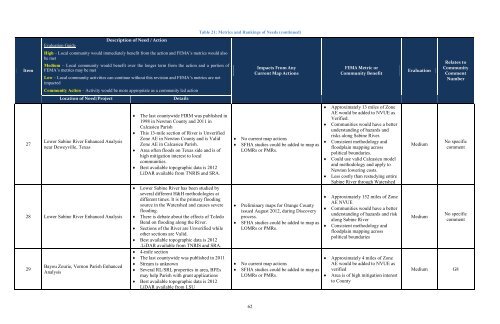
Table 21: Metrics and Rankings of Needs (continued)<br />
Evaluation Guide<br />
Description of Need / Action<br />
Item<br />
High – Local community would immediately benefit from the action and FEMA’s metrics would also<br />
be met<br />
Medium – Local community would benefit over the longer term from the action and a portion of<br />
FEMA’s metrics may be met<br />
Low – Local community activities can continue without this revision and FEMA’s metrics are not<br />
impacted<br />
Impacts From Any<br />
Current Map Actions<br />
FEMA Metric or<br />
Community Benefit<br />
Evaluation<br />
Relates to<br />
Community<br />
Comment<br />
Number<br />
Community Action – Activity would be more appropriate as a community led action<br />
Location of Need/Project<br />
Details<br />
27<br />
<strong>Lower</strong> <strong>Sabine</strong> River Enhanced Analysis<br />
near Deweyville, Texas<br />
28 <strong>Lower</strong> <strong>Sabine</strong> River Enhanced Analysis<br />
29<br />
Bayou Zourie, Vernon Parish Enhanced<br />
Analysis<br />
The last countywide FIRM was published in<br />
1998 in Newton County and 2011 in<br />
Calcasieu Parish<br />
This 13-mile section of River is Unverified<br />
Zone AE in Newton County and is Valid<br />
Zone AE in Calcasieu Parish.<br />
Area often floods on Texas side and is of<br />
high mitigation interest to local<br />
communities.<br />
Best available topographic data is 2012<br />
LiDAR available from TNRIS and SRA.<br />
<strong>Lower</strong> <strong>Sabine</strong> River has been studied by<br />
several different H&H methodologies at<br />
different times. It is the primary flooding<br />
source in the <strong>Watershed</strong> and causes severe<br />
flooding.<br />
There is debate about the effects of Toledo<br />
Bend on flooding along the River.<br />
Sections of the River are Unverified while<br />
other sections are Valid.<br />
Best available topographic data is 2012<br />
.LiDAR available from TNRIS and SRA.<br />
4-mile section<br />
The last countywide was published in 2011<br />
Stream is unknown<br />
Several RL/SRL properties in area, BFEs<br />
may help Parish with grant applications<br />
Best available topographic data is 2012<br />
LiDAR available from LSU<br />
No current map actions<br />
SFHA studies could be added to map as<br />
LOMRs or PMRs.<br />
Preliminary maps for Orange County<br />
issued August 2012, during <strong>Discovery</strong><br />
process.<br />
SFHA studies could be added to map as<br />
LOMRs or PMRs.<br />
No current map actions<br />
SFHA studies could be added to map as<br />
LOMRs or PMRs.<br />
Approximately 13 miles of Zone<br />
AE would be added to NVUE as<br />
Verified.<br />
Communities would have a better<br />
understanding of hazards and<br />
risks along <strong>Sabine</strong> River.<br />
Consistent methodology and<br />
floodplain mapping across<br />
political boundaries.<br />
Could use valid Calcasieu model<br />
and methodology and apply to<br />
Newton lowering costs.<br />
Less costly than restudying entire<br />
<strong>Sabine</strong> River through <strong>Watershed</strong><br />
Approximately 152 miles of Zone<br />
AE NVUE<br />
Communities would have a better<br />
understanding of hazards and risk<br />
along <strong>Sabine</strong> River<br />
Consistent methodology and<br />
floodplain mapping across<br />
political boundaries<br />
Approximately 4 miles of Zone<br />
AE would be added to NVUE as<br />
verified<br />
Area is of high mitigation interest<br />
to County<br />
Medium<br />
Medium<br />
Medium<br />
No specific<br />
comment<br />
No specific<br />
comment<br />
G8<br />
62