Hydrodynamics of the Milk River Formation - Canadian Discovery Ltd.
Hydrodynamics of the Milk River Formation - Canadian Discovery Ltd.
Hydrodynamics of the Milk River Formation - Canadian Discovery Ltd.

You also want an ePaper? Increase the reach of your titles
YUMPU automatically turns print PDFs into web optimized ePapers that Google loves.
-450<br />
-300<br />
-50<br />
950<br />
<strong>Hydrodynamics</strong> <strong>of</strong> <strong>the</strong> <strong>Milk</strong> <strong>River</strong> <strong>Formation</strong><br />
Original <strong>Milk</strong> <strong>River</strong> Study Objectives<br />
The 2003 non-exclusive <strong>Milk</strong> <strong>River</strong> hydrodynamic study<br />
levers <strong>the</strong> substantial expertise RPCL has developed using<br />
integrated geoscience analysis for <strong>the</strong> purpose <strong>of</strong> defining<br />
unconventional gas resources.<br />
This exploration oriented study focusses on defining<br />
<strong>the</strong> boundaries <strong>of</strong> <strong>the</strong> unconventional (gas-saturated),<br />
transitional (gas and water) and conventional (water wet)<br />
portions <strong>of</strong> <strong>the</strong> play. Detailed stratigraphic analysis and<br />
hydrodynamic modelling is used to determine <strong>the</strong> trapping<br />
mechanisms, play limits and exploration fairways.<br />
Some <strong>of</strong> <strong>the</strong> key questions addressed by <strong>the</strong> study are:<br />
• What is <strong>the</strong> relationship between sequence stratigraphy,<br />
hydrodynamics and trapping?<br />
• Where are <strong>the</strong> recharge points and how active is <strong>the</strong><br />
aquifer system?<br />
• What is <strong>the</strong> relationship between aquifer recharge<br />
zones and topography?<br />
• What are <strong>the</strong> downdip and updip extents <strong>of</strong> <strong>the</strong><br />
play?<br />
• Is <strong>the</strong>re a petrophysical model that will identify pay<br />
intervals?<br />
• What is <strong>the</strong> relationship between reservoir quality<br />
(porosity/permeability) and gas pay?<br />
• What are <strong>the</strong> source rocks and is <strong>the</strong> gas <strong>of</strong> biogenic<br />
origin?<br />
• What are <strong>the</strong> effective gas migration patterns, in both<br />
<strong>the</strong> conventional and unconventional play types?<br />
• Are <strong>the</strong>re systematic controls on water cuts?<br />
30<br />
49°<br />
114°<br />
50°<br />
5<br />
N<br />
10<br />
51°<br />
15<br />
-1050<br />
T<br />
PINCHER<br />
CREEK<br />
CALGARY<br />
20<br />
LEGEND<br />
T<br />
K SM<br />
-300<br />
25<br />
-700<br />
30<br />
-250<br />
-200<br />
-150<br />
-100<br />
25<br />
-50<br />
0<br />
Herronton<br />
FT MACLEOD<br />
Structure (m)<br />
Gas Pool<br />
Tertiary<br />
St. Mary<br />
0 50 km<br />
-150<br />
50<br />
150<br />
T<br />
30<br />
N<br />
25<br />
350<br />
50<br />
250<br />
37<br />
T<br />
N<br />
T<br />
R10W<br />
35 T<br />
N<br />
100<br />
450<br />
150<br />
600<br />
750<br />
GLACIER<br />
TETON<br />
113° 112° 111° 110° 109°<br />
550<br />
20<br />
200<br />
R5W<br />
20<br />
DRUMHELLER<br />
K SM<br />
R5W<br />
15<br />
R10W R1E<br />
250<br />
LETHBRIDGE<br />
950<br />
800<br />
1100<br />
1050<br />
1050<br />
PONDERA<br />
300<br />
TABER<br />
850<br />
R1W<br />
K SM<br />
350<br />
R1W<br />
TOOLE<br />
15<br />
BROOKS<br />
R1E<br />
10<br />
R5E<br />
T<br />
30<br />
N<br />
R5E<br />
35 T<br />
N<br />
37 T<br />
N<br />
10<br />
ALBERTA<br />
5<br />
R10E<br />
R10E<br />
5<br />
5<br />
10<br />
15<br />
1W4 30<br />
MONTANA<br />
48°<br />
113° 112° 111° 110°<br />
750<br />
700<br />
Bow Island Arch<br />
1200<br />
1050<br />
<strong>Milk</strong> <strong>River</strong><br />
Outcrop/Eroded<br />
Sweetgrass Arch<br />
650<br />
1150<br />
1100<br />
400<br />
450<br />
600<br />
LIBERTY<br />
Medicine Hat<br />
550<br />
800<br />
500<br />
750<br />
CHOUTEAU<br />
MEDICINE HAT<br />
Rudyard<br />
700<br />
HILL<br />
Laredo<br />
600<br />
Bullwacker<br />
20<br />
R15E<br />
25<br />
30<br />
25<br />
25<br />
SASKATCHEWAN<br />
Lakeside<br />
R15E<br />
400<br />
Rough Ridge<br />
500<br />
Hatton<br />
Cypress Hills<br />
Brown's Coulee<br />
Tiger Ridge<br />
650<br />
750<br />
600<br />
850<br />
R20E<br />
350<br />
350<br />
R20E<br />
Battle Creek<br />
Xena Fresno Coal Coulee<br />
Lohman<br />
Havre<br />
Bowes<br />
BLAINE<br />
Bearpaw Mountain<br />
Sawtooth Mtn.<br />
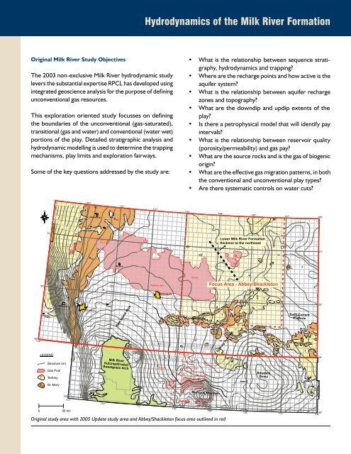
Original study area with 2005 Update study area and Abbey/Shackleton focus area outlined in red<br />
K SM<br />
T<br />
109°<br />
650<br />
350<br />
300<br />
350<br />
400<br />
20<br />
450<br />
R25E<br />
20<br />
550<br />
R25E<br />
500<br />
300<br />
500<br />
450<br />
250<br />
550<br />
15<br />
R30E<br />
108° 107° 106°<br />
15<br />
Lower <strong>Milk</strong> <strong>River</strong> <strong>Formation</strong><br />
thickens to <strong>the</strong> nor<strong>the</strong>ast<br />
Abbey<br />
Focus Area - Abbey/Shackleton<br />
K SM<br />
T<br />
Coburg Syncline<br />
T<br />
K SM<br />
T<br />
600<br />
250<br />
300<br />
SWIFT CURRENT<br />
PHILLIPS<br />
R30E<br />
300<br />
K SM<br />
T<br />
T<br />
Bowdoin<br />
Dome<br />
10<br />
10<br />
5<br />
30<br />
25<br />
20<br />
15<br />
10<br />
5<br />
5 1W3<br />
49°<br />
T<br />
37<br />
T<br />
N<br />
R35E<br />
37<br />
N<br />
R40E<br />
T<br />
35<br />
N<br />
T<br />
35<br />
N<br />
30 T<br />
N<br />
R35E<br />
108° 107°<br />
250<br />
650<br />
150<br />
350<br />
200<br />
200<br />
150<br />
K SM<br />
300<br />
400<br />
350<br />
150<br />
VALLEY<br />
R40E<br />
200<br />
250<br />
WOOD MOUNTAIN<br />
250<br />
100<br />
Swift Current<br />
Platform<br />
T<br />
200<br />
300<br />
250<br />
150<br />
K SM<br />
100<br />
200<br />
26<br />
N<br />
T<br />
T<br />
30<br />
N<br />
106°<br />
51°<br />
50°<br />
48°