Hydrodynamics of the Milk River Formation - Canadian Discovery Ltd.
Hydrodynamics of the Milk River Formation - Canadian Discovery Ltd.
Hydrodynamics of the Milk River Formation - Canadian Discovery Ltd.

You also want an ePaper? Increase the reach of your titles
YUMPU automatically turns print PDFs into web optimized ePapers that Google loves.
<strong>Hydrodynamics</strong> <strong>of</strong> <strong>the</strong> <strong>Milk</strong> <strong>River</strong><br />
<strong>Formation</strong> - 2005 Update<br />
D e p th m -> 200 225 250 275 300 325 350 375 400<br />
0 PAYFLAG 20 2 RESD 200 .3 Porosity 0 1 -1<br />
WATER SAT 0 Shale 1<br />
1 Porosity 0<br />
150 Caliper 400<br />
.3 BVW 0<br />
2 RESS 200 10 QUAL1 0<br />
1 COAL 0<br />
0 Gamma Ray 150<br />
0 QUAL2 100<br />
-150 SP 100<br />
U_ALD<br />
___________________________________________________________________________________<br />
CORE_TOP ___________________________________________________________________________________<br />
L_ALD<br />
___________________________________________________________________________________<br />
CORE_BAS ___________________________________________________________________________________<br />
1WSP<br />
PERF<br />
___________________________________________________________________________________<br />
1WSP_BAS ___________________________________________________________________________________<br />
3 7 5<br />
K B = 5 8 0 .3<br />
3 5 0<br />
3 2 5<br />
3 0 0<br />
2 7 5<br />
2 5 0<br />
2 2 5<br />
2 0 0<br />
Introduction<br />
The <strong>Milk</strong> <strong>River</strong> <strong>Formation</strong> in sou<strong>the</strong>ast Alberta and<br />
southwest Saskatchewan forms one <strong>of</strong> <strong>the</strong> true giants<br />
among North American gas fields. Discovered nearly<br />
100 years ago, <strong>the</strong> field has been under continual<br />
development.<br />
With over 30,000 producing wells, <strong>the</strong> play is still<br />
considered immature as many aspects are poorly<br />
understood, including:<br />
• What controls <strong>the</strong> traps - stratigraphy, structure,<br />
lithology or hydrodynamics?<br />
• Where are <strong>the</strong> potential play extensions likely to<br />
occur?<br />
With extensions such as Abbey/Shackelton and frenzied<br />
land sale activity, <strong>the</strong>re appears to much more gas to <strong>the</strong><br />
play than previously considered.<br />
However, distinctive log signatures for pay are subtle.<br />
Traditional petrophysics is hampered by <strong>the</strong> shaly lithology<br />
causing a negligible separation from pay zones to wet<br />
zones. Porosity logs are <strong>of</strong>ten invalid due to a tendency<br />
for wellbore caving through <strong>the</strong> zone.<br />
Past studies <strong>of</strong> <strong>the</strong> <strong>Milk</strong> <strong>River</strong> <strong>Formation</strong> have shown <strong>the</strong><br />
regional stratigraphic complexity <strong>of</strong> an updip ‘dynamic’<br />
aquifer system. How does all <strong>of</strong> this inter-relate?<br />
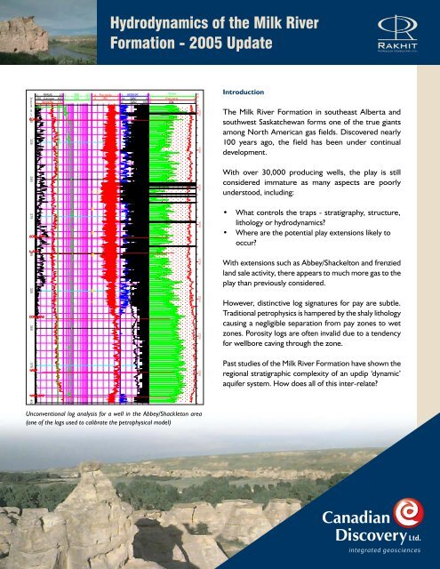
Unconventional log analysis for a well in <strong>the</strong> Abbey/Shackleton area<br />
(one <strong>of</strong> <strong>the</strong> logs used to calibrate <strong>the</strong> petrophysical model)<br />
P E R F 2 5 8 . 0 2 5 9 .0 2 6 9 .0 2 7 1 .0 2 8 5 .0 2 8 7 .0 3 0 0 .0 3 0 2 .0 3 2 4 .0 3 2 6 .0 3 3 2 .0 3 3 3 .0<br />
1 7 5<br />
<strong>Canadian</strong><br />
<strong>Discovery</strong> <strong>Ltd</strong>.<br />
integrated geosciences
-450<br />
-300<br />
-50<br />
950<br />
<strong>Hydrodynamics</strong> <strong>of</strong> <strong>the</strong> <strong>Milk</strong> <strong>River</strong> <strong>Formation</strong><br />
Original <strong>Milk</strong> <strong>River</strong> Study Objectives<br />
The 2003 non-exclusive <strong>Milk</strong> <strong>River</strong> hydrodynamic study<br />
levers <strong>the</strong> substantial expertise RPCL has developed using<br />
integrated geoscience analysis for <strong>the</strong> purpose <strong>of</strong> defining<br />
unconventional gas resources.<br />
This exploration oriented study focusses on defining<br />
<strong>the</strong> boundaries <strong>of</strong> <strong>the</strong> unconventional (gas-saturated),<br />
transitional (gas and water) and conventional (water wet)<br />
portions <strong>of</strong> <strong>the</strong> play. Detailed stratigraphic analysis and<br />
hydrodynamic modelling is used to determine <strong>the</strong> trapping<br />
mechanisms, play limits and exploration fairways.<br />
Some <strong>of</strong> <strong>the</strong> key questions addressed by <strong>the</strong> study are:<br />
• What is <strong>the</strong> relationship between sequence stratigraphy,<br />
hydrodynamics and trapping?<br />
• Where are <strong>the</strong> recharge points and how active is <strong>the</strong><br />
aquifer system?<br />
• What is <strong>the</strong> relationship between aquifer recharge<br />
zones and topography?<br />
• What are <strong>the</strong> downdip and updip extents <strong>of</strong> <strong>the</strong><br />
play?<br />
• Is <strong>the</strong>re a petrophysical model that will identify pay<br />
intervals?<br />
• What is <strong>the</strong> relationship between reservoir quality<br />
(porosity/permeability) and gas pay?<br />
• What are <strong>the</strong> source rocks and is <strong>the</strong> gas <strong>of</strong> biogenic<br />
origin?<br />
• What are <strong>the</strong> effective gas migration patterns, in both<br />
<strong>the</strong> conventional and unconventional play types?<br />
• Are <strong>the</strong>re systematic controls on water cuts?<br />
30<br />
49°<br />
114°<br />
50°<br />
5<br />
N<br />
10<br />
51°<br />
15<br />
-1050<br />
T<br />
PINCHER<br />
CREEK<br />
CALGARY<br />
20<br />
LEGEND<br />
T<br />
K SM<br />
-300<br />
25<br />
-700<br />
30<br />
-250<br />
-200<br />
-150<br />
-100<br />
25<br />
-50<br />
0<br />
Herronton<br />
FT MACLEOD<br />
Structure (m)<br />
Gas Pool<br />
Tertiary<br />
St. Mary<br />
0 50 km<br />
-150<br />
50<br />
150<br />
T<br />
30<br />
N<br />
25<br />
350<br />
50<br />
250<br />
37<br />
T<br />
N<br />
T<br />
R10W<br />
35 T<br />
N<br />
100<br />
450<br />
150<br />
600<br />
750<br />
GLACIER<br />
TETON<br />
113° 112° 111° 110° 109°<br />
550<br />
20<br />
200<br />
R5W<br />
20<br />
DRUMHELLER<br />
K SM<br />
R5W<br />
15<br />
R10W R1E<br />
250<br />
LETHBRIDGE<br />
950<br />
800<br />
1100<br />
1050<br />
1050<br />
PONDERA<br />
300<br />
TABER<br />
850<br />
R1W<br />
K SM<br />
350<br />
R1W<br />
TOOLE<br />
15<br />
BROOKS<br />
R1E<br />
10<br />
R5E<br />
T<br />
30<br />
N<br />
R5E<br />
35 T<br />
N<br />
37 T<br />
N<br />
10<br />
ALBERTA<br />
5<br />
R10E<br />
R10E<br />
5<br />
5<br />
10<br />
15<br />
1W4 30<br />
MONTANA<br />
48°<br />
113° 112° 111° 110°<br />
750<br />
700<br />
Bow Island Arch<br />
1200<br />
1050<br />
<strong>Milk</strong> <strong>River</strong><br />
Outcrop/Eroded<br />
Sweetgrass Arch<br />
650<br />
1150<br />
1100<br />
400<br />
450<br />
600<br />
LIBERTY<br />
Medicine Hat<br />
550<br />
800<br />
500<br />
750<br />
CHOUTEAU<br />
MEDICINE HAT<br />
Rudyard<br />
700<br />
HILL<br />
Laredo<br />
600<br />
Bullwacker<br />
20<br />
R15E<br />
25<br />
30<br />
25<br />
25<br />
SASKATCHEWAN<br />
Lakeside<br />
R15E<br />
400<br />
Rough Ridge<br />
500<br />
Hatton<br />
Cypress Hills<br />
Brown's Coulee<br />
Tiger Ridge<br />
650<br />
750<br />
600<br />
850<br />
R20E<br />
350<br />
350<br />
R20E<br />
Battle Creek<br />
Xena Fresno Coal Coulee<br />
Lohman<br />
Havre<br />
Bowes<br />
BLAINE<br />
Bearpaw Mountain<br />
Sawtooth Mtn.<br />
Original study area with 2005 Update study area and Abbey/Shackleton focus area outlined in red<br />
K SM<br />
T<br />
109°<br />
650<br />
350<br />
300<br />
350<br />
400<br />
20<br />
450<br />
R25E<br />
20<br />
550<br />
R25E<br />
500<br />
300<br />
500<br />
450<br />
250<br />
550<br />
15<br />
R30E<br />
108° 107° 106°<br />
15<br />
Lower <strong>Milk</strong> <strong>River</strong> <strong>Formation</strong><br />
thickens to <strong>the</strong> nor<strong>the</strong>ast<br />
Abbey<br />
Focus Area - Abbey/Shackleton<br />
K SM<br />
T<br />
Coburg Syncline<br />
T<br />
K SM<br />
T<br />
600<br />
250<br />
300<br />
SWIFT CURRENT<br />
PHILLIPS<br />
R30E<br />
300<br />
K SM<br />
T<br />
T<br />
Bowdoin<br />
Dome<br />
10<br />
10<br />
5<br />
30<br />
25<br />
20<br />
15<br />
10<br />
5<br />
5 1W3<br />
49°<br />
T<br />
37<br />
T<br />
N<br />
R35E<br />
37<br />
N<br />
R40E<br />
T<br />
35<br />
N<br />
T<br />
35<br />
N<br />
30 T<br />
N<br />
R35E<br />
108° 107°<br />
250<br />
650<br />
150<br />
350<br />
200<br />
200<br />
150<br />
K SM<br />
300<br />
400<br />
350<br />
150<br />
VALLEY<br />
R40E<br />
200<br />
250<br />
WOOD MOUNTAIN<br />
250<br />
100<br />
Swift Current<br />
Platform<br />
T<br />
200<br />
300<br />
250<br />
150<br />
K SM<br />
100<br />
200<br />
26<br />
N<br />
T<br />
T<br />
30<br />
N<br />
106°<br />
51°<br />
50°<br />
48°
2005 Update - T. 1-30, R. 1W3M-1W5M<br />
SW<br />
Alberta<br />
Saskatchewan<br />
NE<br />
<strong>Milk</strong> <strong>River</strong><br />
Lea Park / Alderson Member<br />
Limit <strong>of</strong> Lowstand<br />
Transgression<br />
Pakowki<br />
Dead Horse<br />
Coulee<br />
Virgelle (Wet) Sand<br />
Datum<br />
Upper Alderson<br />
Telegraph Creek<br />
Lower Alderson<br />
1st White Specks<br />
BOW ISLAND ARCH<br />
Schematic SW-NE cross-section <strong>of</strong> <strong>the</strong> <strong>Milk</strong> <strong>River</strong> <strong>Formation</strong>, SE Alberta/SW Saskatchewan<br />
Unconformity<br />
Transgressive Erosional Surface<br />
Sequence Boundary<br />
Low Stand Sands<br />
2005 <strong>Milk</strong> Update Update<br />
Since <strong>the</strong> original <strong>Milk</strong> <strong>River</strong> study, extensive activity has<br />
occurred. Thousands <strong>of</strong> new wells have been drilled or<br />
completed in <strong>the</strong> <strong>Milk</strong> <strong>River</strong>, many <strong>of</strong> which are outside<br />
<strong>of</strong> <strong>the</strong> originally defined pool boundaries.<br />
The update will incorporate <strong>the</strong> data from key wells<br />
released since <strong>the</strong> May 2003 cut-<strong>of</strong>f date. Special attention<br />
will be paid to where new discoveries have been made<br />
or where existing pool boundaries have been extended<br />
by recent activity.<br />
All new reservoir pressure, fluid chemistry and production<br />
data for <strong>the</strong> <strong>Milk</strong> <strong>River</strong> will also be analysed and <strong>the</strong> original<br />
hydrogeological model will be updated.<br />
A focus area centered on <strong>the</strong> Abbey/Shackleton play<br />
will also be part <strong>of</strong> <strong>the</strong> update. In this area, <strong>the</strong> original<br />
geological model for <strong>the</strong> <strong>Milk</strong> <strong>River</strong>, Alderson member<br />
has been fur<strong>the</strong>r developed to give new insights as to how<br />
this play is evolving and where it is going.<br />
More petrophysical analysis has also been conducted<br />
on key wells using <strong>the</strong> shaly sand model developed in<br />
<strong>the</strong> original study. The results <strong>of</strong> fur<strong>the</strong>r analysis will be<br />
provided in <strong>the</strong> 2005 <strong>Milk</strong> <strong>River</strong> update with a discussion<br />
<strong>of</strong> <strong>the</strong> efficacy <strong>of</strong> <strong>the</strong> model for identifying reservoir.<br />
GIS Powered by<br />
Available Exclusively from<br />
Rakhit Petroleum Consulting <strong>Ltd</strong>.
http://www.uleth.ca/vft/milkriver/<br />
2005 <strong>Milk</strong> <strong>River</strong> Update Deliverables<br />
Geology:<br />
• Series <strong>of</strong> regional geologic cross-sections<br />
• Pressure data wells correlated<br />
• Regional geologic interpretation<br />
• New geologic maps for focus area<br />
<strong>Hydrodynamics</strong>:<br />
• Detailed pressure versus elevation graphs<br />
• DST and AOF data analyses<br />
• Pressure systems related to regional geology,<br />
topography and outcrop<br />
• Analysis <strong>of</strong> gas distribution, hydrocarbon column<br />
heights, sequence relationships, downdip(?) and updip<br />
water<br />
• Hydraulic head and gas head maps<br />
• Gas migration modelling<br />
Hydrochemistry:<br />
• Gas chemistry composition and distribution<br />
• Water chemistry composition and distribution<br />
• Gas source and generation analyses<br />
• Secondary and primary biogenic gas analysis<br />
Petrophysics:<br />
• Log analysis report and petrophysical model<br />
Technical Report:<br />
• Illustrated technical report with discussion <strong>of</strong> gas<br />
source, trapping and history evolution<br />
• Bound hard copy <strong>of</strong> maps, graphs and figures<br />
• Digital data<br />
• Digital PDF report on CD<br />
N<br />
30<br />
25<br />
113° 112° 111° 110° 109°<br />
20<br />
DRUMHELLER<br />
15<br />
10<br />
5<br />
30<br />
25<br />
20<br />
108° 107° 106°<br />
15<br />
10<br />
5<br />
30<br />
51°<br />
CALGARY<br />
25<br />
25<br />
20<br />
Herronton<br />
25<br />
51°<br />
15<br />
BROOKS<br />
20<br />
Abbey<br />
20<br />
Hatton<br />
50°<br />
Medicine Hat<br />
15<br />
Focus Area - Abbey/Shackleton<br />
SWIFT CURRENT<br />
15<br />
10<br />
MEDICINE HAT<br />
30<br />
49°<br />
114°<br />
PINCHER<br />
CREEK<br />
5<br />
FT MACLEOD<br />
25<br />
0 50 km<br />
LETHBRIDGE<br />
20<br />
TABER<br />
<strong>Milk</strong> <strong>River</strong><br />
Outcrop<br />
15<br />
Bow Island Arch<br />
10<br />
ALBERTA<br />
113° 112° 111° 110°<br />
5<br />
5<br />
10<br />
1W4 30<br />
Cypress Hills<br />
SASKATCHEWAN<br />
25<br />
109°<br />
Coburg Syncline<br />
20<br />
15<br />
10<br />
Swift Current<br />
Platform<br />
WOOD MOUNTAIN<br />
K SM<br />
10<br />
5<br />
5 1W3<br />
49°<br />
108° 107° 106°<br />
50°<br />
2005 Update study area showing over 8,000 new wells drilled and <strong>Milk</strong> <strong>River</strong> completions since April 2003<br />
Contact Cheryl Wright<br />
300, 706 – 7 Avenue SW, Calgary AB, T2P 0Z1<br />
T 403.269.3644 E cwright@canadiandiscovery.com<br />
MRHD-V02-2010.10.25<br />
<strong>Canadian</strong><br />
<strong>Discovery</strong> <strong>Ltd</strong>.<br />
www.canadiandiscovery.com