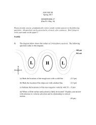
New Aviation Weather Formats: METAR/TAF
New Aviation Weather Formats: METAR/TAF
New Aviation Weather Formats: METAR/TAF

You also want an ePaper? Increase the reach of your titles
YUMPU automatically turns print PDFs into web optimized ePapers that Google loves.
<strong>METAR</strong> (SPECI or Special Report)<br />
Note: When <strong>METAR</strong> data is missing (e.g. dew point), it is simply omitted and the user must know the sequence to recognize this.<br />
Some exceptions apply in remarks such as RVRNO, or SLPNO when RVR or SLP are normally reported but not currently available.<br />
<strong>METAR</strong> KPIT 201955Z 22015G25KT 3/4SM R28R/2600FT TSRA OVC010CB 18/16 A2992 RMK SLP013 T01760158<br />
Where:<br />
KPIT<br />
When:<br />
201955Z 20th day of month at 1955Z<br />
Wind:<br />
22015G25KT 220 degrees at 15 gusting to 25 knots<br />
V: Variable direction e.g., 20015KT 220V280<br />
VRB:<br />
Variable direction when speed is less than or equal to 6 knots<br />
Visibility: 3/4SM 3/4 statute miles, typical: 2 3/4SM, 1SM,<br />
RVR R28R/2600FT Runway 28 Right visibility 2600 feet<br />
M: Used for RVR less than lowest reportable sensor value (e.g. M600FT)<br />
P: Used for RVR greater than highest reportable sensor value (e.g. P6000FT)<br />
V: Variable<br />
Significant <strong>Weather</strong>: TSRA thunderstorm/moderate rain (See Abbreviations)<br />
Sky Condition: OVC010CB overcast clouds at 1000 feet consisting of cumulonimbus<br />
Typical: SKC, FEW, SCT, BKN, VV004indefinite ceiling (Vertical Visibility)<br />
400 feet or V V///indefinite ceiling height not available<br />
Temperature/Dew Point: 18/16 18 degrees Celsius/dew point 16 degrees Celsius<br />
M = Minus (below zero)<br />
Altimeter: A2992 inches of mercury and preceded by an "A"<br />
RMK SLP013 T01760158 10142 20012 401120084At selected stations, Sea Level Pressure is reported as the last three digits in<br />
hectoPascals (milibars) (e.g., 1013 is reported as SLP013). Codes such as T01760158 10142 20012 and 401120084 are climate<br />
temperature information.<br />
<strong>TAF</strong> (<strong>TAF</strong> AMD is Amended Forecastwhen included)<br />
KPIT 091720Z 091818 22020KT WS015/30045KT 3SM -SHRA BKN020<br />
FM2030 30015G25KT 3SM SHRA OVC015 PROB40 2022 1/2 TSRA OVC008CB<br />
FM2300 27008KT 5SM -SHRA BKN020 OVC040 TEMPO 0407 00000KT 1SM -RA FG<br />
FM1000 22010KT 5SM -SHRA OVC020 BECMG 1315 20010KT P6SM NSW SKC<br />
Where: KPIT<br />
When: 091720Z issuance day and time: 9th day at 1720Z<br />
091818 valid period: 9th day at 1800Z to next day (10th) at 1800Z<br />
Wind: 22020KT WS015/30045KT220 degrees at 20 knots with low level wind shear at 1500 feet forecast to be 300 degrees at<br />
45 knots (only nonconvective, low level, wind shear is forecast)<br />
Visibility: 3SM 3 statute miles, typical - 2 3/4SM, 1SM,<br />
P6SM: Greater than 6 statute miles<br />
Significant Wx: -SHRA light rain showers (See Abbreviations)<br />
Sky Condition: BKN020 broken clouds at 2000 feet.<br />
Typical: FEW, SCT, BKN, OVC.<br />
VV004 indefinite ceiling (Vertical Visibility) 400 feet or VV///. Indefinite ceiling height not available CB and TCU<br />
clouds noted when present.<br />
Sequence of Wind, Visibility, Significant <strong>Weather</strong> and Sky Condition repeats preceded by:<br />
FM2030: rom 2030Z<br />
PROB40 2022: here is a 40 percent probability between 2000Zand 2200Z.<br />
FM2300: From 2300Z<br />
TEMPO 0407: Temporarily between 0400Z and 0700Z<br />
FM1000:<br />
From 1000Z<br />
BECMG 1315: Becoming between 1300Z and 1500Z<br />
Note: <strong>Weather</strong> conditions such as wind and sky condition may be omitted after PROB40, TEMPO, and BECMGif no change is<br />
expected from those same conditions given in the previous time block.