indian notices to mariners - Indian Naval Hydrographic Department
indian notices to mariners - Indian Naval Hydrographic Department
indian notices to mariners - Indian Naval Hydrographic Department
You also want an ePaper? Increase the reach of your titles
YUMPU automatically turns print PDFs into web optimized ePapers that Google loves.
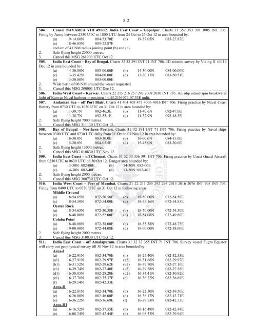
5. 2<br />
504. Cancel NAVAREA VIII 491/12. India East Coast – Gopalpur. Charts 31 352 353 391 3005 INT 706.<br />
Firing by Army between 2330 UTC <strong>to</strong> 1800 UTC from 24 Oct <strong>to</strong> 26 Oct 12 in area bounded by:<br />
(a) 19-14.60N 084-53.70E (b) 19-37.05N 085-27.87E<br />
(c) 18-46.05N 085-22.87E<br />
and arc of 41 NM radius joining point (b) and (c).<br />
2. Safe flying height 25000 metres.<br />
3. Cancel this MSG 261900 UTC Oct 12.<br />
505. India East Coast – Bay of Bengal. Charts 32 33 391 INT 71 INT 706. 3D seismic survey by Viking II till 19<br />
Dec 12 in area bounded by:<br />
(a) 14-30.00N 083-00.00E (b) 14-30.00N 084-00.00E<br />
(c) 13-35.42N 084-00.00E (d) 13-30.17N 083-50.51E<br />
(e) 13-30.00N 083-00.00E<br />
2. Wide berth of 06 NM around the vessel requested.<br />
3. Cancel this MSG 200001 UTC Dec 12.<br />
506. India West Coast – Karwar. Charts 22 215 216 257 293 2008 2010 INT 705. Anjadip island spur breakwater<br />
light of Karwar <strong>Naval</strong> harbour in position 14-45.21N 074-07.33E unlit.<br />
507. Andaman Sea – off Port Blair. Charts 41 404 405 473 4006 4016 INT 706. Firing practice by <strong>Naval</strong> Coast<br />
Battery from 0730 UTC <strong>to</strong> 1030 UTC on 31 Oct 12 in area bounded by:<br />
(a) 11-39.7N 092-46.3E (b) 11-40.6N 092-47.0E<br />
(c) 11-38.7N 092-53.1E (d) 11-32.9N 092-48.3E<br />
2. Safe flying height 7000 metres.<br />
3. Cancel this MSG 311130 UTC Oct 12.<br />
508. Bay of Bengal – Northern Portion. Charts 31 32 391 INT 71 INT 706. Firing practice by <strong>Naval</strong> ships<br />
between 0300 UTC and 0730 UTC daily from 31 Oct <strong>to</strong> 01 Nov 12 in area bounded by:<br />
(a) 16-30.0N 083-30.0E (b) 16-00.0N 084-15.0E<br />
(c) 15-20.0N 084-05.5E (d) 15-45.0N 083-30.0E<br />
2. Safe flying height 13000 metres.<br />
3. Cancel this MSG 010830 UTC Nov 12.<br />
509. India East Coast – off Chennai. Charts 31 32 33 356 391 INT 706. Firing practice by Coast Guard Aircraft<br />
from 0230 UTC <strong>to</strong> 0630 UTC on 30 Oct 12. Danger area bounded by:<br />
(a) 13-30N 082-00E (b) 14-30N 082-00E<br />
(c) 14-30N 082-40E (d) 13-30N 082-40E<br />
2. Safe flying height 2000 metres.<br />
3. Cancel this MSG 300730 UTC Oct 12.<br />
510. India West Coast – Port of Mumbai. Charts 21 22 211 255 292 293 2015 2016 2076 INT 705 INT 706.<br />
Firing from 0400 UTC <strong>to</strong> 0730 UTC on 31 Oct 12 in following areas:<br />
Middle Ground<br />
(a) 18-54.65N 072-50.58E (b) 18-50.00N 072-54.50E<br />
(c) 18-54.50N 072-54.00E (d) 18-55.16N 072-54.83E<br />
Oyster Rock<br />
(a) 18-54.65N 072-50.58E (b) 18-50.00N 072-54.50E<br />
(c) 18-48.00N 072-52.00E (d) 18-54.08N 072-49.80E<br />
Colaba Point<br />
(a) 18-48.00N 072-38.00E (b) 18-53.58N 072-48.75E<br />
(c) 19-00.00N 072-44.08E (d) 19-00.00N 072-38.00E<br />
2. Safe flying height 2000 metres.<br />
3. Cancel this MSG 310830 UTC Oct 12.<br />
511. India East Coast – off Amalapuram. Charts 31 32 33 355 INT 71 INT 706. Survey vessel Fugro Equa<strong>to</strong>r<br />
will carry out geophysical survey till 30 Nov 12 in area bounded by:<br />
Area-I<br />
(a) 16-22.91N 082-34.70E (h) 16-25.40N 082-32.33E<br />
(a1) 16-27.91N 082-29.97E (a2) 16-31.68N 082-29.97E<br />
(b1) 16-31.52N 082-29.62E (b2) 16-39.70N 082-27.10E<br />
(c1) 16-39.74N 082-27.40E (c2) 16-39.58N 082-27.58E<br />
(d1) 16-38.05N 082-28.20E (d2) 16-34.41N 082-30.92E<br />
(e1) 16-37.78N 082-35.37E (e) 16-36.22N 082-36.69E<br />
(f) 16-29.54N 082-42.33E<br />
Area-II<br />
(a) 16-22.91N 082-34.70E (b) 16-22.50N 082-39.50E<br />
(c) 16-26.00N 082-46.00E (d) 16-36.17N 082-43.71E<br />
(e) 16-36.22N 082-36.69E (f) 16-29.53N 082-42.33E<br />
Area-III<br />
(a) 16-16.52N 082-37.55E (b) 16-16.49N 082-42.44E<br />
(c) 16-08.24N 082-42.44E (d) 16-08.33N 082-29.94E


