indian notices to mariners - Indian Naval Hydrographic Department
indian notices to mariners - Indian Naval Hydrographic Department
indian notices to mariners - Indian Naval Hydrographic Department
Create successful ePaper yourself
Turn your PDF publications into a flip-book with our unique Google optimized e-Paper software.
2.1<br />
SECTION – II<br />
PERMANENT NOTICES<br />
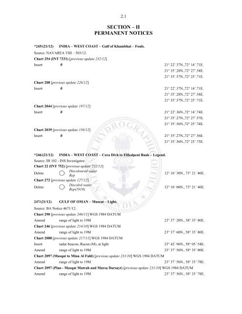
*245/(21/12) INDIA – WEST COAST – Gulf of Khambhat – Fouls.<br />
Source: NAVAREA VIII – 503/12.<br />
Chart 254 (INT 7331) [previous update 232/12]<br />
Insert # 21° 22’.37N.,72° 14’.71E.<br />
21° 35’.28N.,72° 27’.54E.<br />
21° 35’.57N.,72° 25’.71E.<br />
Chart 208 [previous update 226/12]<br />
Insert # 21° 22’.37N.,72° 14’.71E.<br />
21° 35’.28N.,72° 27’.54E.<br />
21° 35’.57N.,72° 25’.71E.<br />
Chart 2044 [previous update 197/12]<br />
Insert # 21° 22’.36N.,72° 14’.74E.<br />
21° 35’.27N.,72° 27’.57E.<br />
21° 35’.56N.,72° 25’.74E.<br />
Chart 2039 [previous update 156/12]<br />
Insert # 21° 35’.27N.,72° 27’.56E.<br />
21° 35’.56N.,72° 25’.73E.<br />
*246/(21/12) INDIA – WEST COAST – Cora Divh <strong>to</strong> Elikalpeni Bank – Legend.<br />
Source: IH 102 - INS Investiga<strong>to</strong>r.<br />
Chart 22 (INT 752) [previous update 222/12]<br />
Delete<br />
Discoloured water<br />
Rep<br />
12° 10´·30N., 73° 21´·40E.<br />
Chart 272 [previous update 127/12]<br />
Delete<br />
Discolrd water<br />
Rep(1919)<br />
12° 10´·00N., 73° 21´·40E.<br />
247/(21/12) GULF OF OMAN – Muscat – Light.<br />
Source: BA Notice 4671/12.<br />
Chart 290 [previous update 246/11] WGS 1984 DATUM<br />
Amend range of light <strong>to</strong> 19M 23° 37´·20N., 58° 35´·80E.<br />
Chart 246 [previous update 214/10] WGS 1984 DATUM<br />
Amend range of light <strong>to</strong> 19M 23° 37´·60N., 58° 35´·80E.<br />
Chart 2088 [previous update 217/11] WGS 1984 DATUM<br />
Insert radar beacon, Racon (M), at light 23° 42´·96N., 58° 05´·54E.<br />
Amend range of light <strong>to</strong> 19M 23° 37´·56N., 58° 35´·80E.<br />
Chart 2097 (Masqat <strong>to</strong> Mina Al Fahl) [previous update 231/10] WGS 1984 DATUM<br />
Amend range of light <strong>to</strong> 19M 23° 37´·56N., 58° 35´·78E.<br />
Chart 2097 (Plan - Masqat Matrah and Marsa Darsayt) [previous update 231/10] WGS 1984 DATUM<br />
Amend range of light <strong>to</strong> 19M 23° 37´·56N., 58° 35´·78E.


