ArcGIS Extensions - Esri Portugal
ArcGIS Extensions - Esri Portugal
ArcGIS Extensions - Esri Portugal

You also want an ePaper? Increase the reach of your titles
YUMPU automatically turns print PDFs into web optimized ePapers that Google loves.
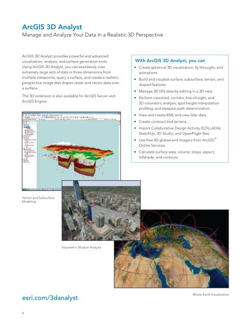
<strong>ArcGIS</strong> 3D Analyst<br />
Manage and Analyze Your Data in a Realistic 3D Perspective<br />
<strong>ArcGIS</strong> 3D Analyst provides powerful and advanced<br />
visualization, analysis, and surface generation tools.<br />
Using <strong>ArcGIS</strong> 3D Analyst, you can seamlessly view<br />
extremely large sets of data in three dimensions from<br />
multiple viewpoints, query a surface, and create a realistic<br />
perspective image that drapes raster and vector data over<br />
a surface.<br />
The 3D extension is also available for <strong>ArcGIS</strong> Server and<br />
<strong>ArcGIS</strong> Engine.<br />
With <strong>ArcGIS</strong> 3D Analyst, you can<br />
• Create spherical 3D visualization, fly-throughs, and<br />
animations.<br />
• Build and visualize surface, subsurface, terrain, and<br />
draped features.<br />
• Manage 3D GIS data by editing in a 3D view.<br />
• Perform viewshed, corridor, line-of-sight, and<br />
3D volumetric analysis; spot height interpolation<br />
profiling; and steepest path determination.<br />
• View and create KML and view lidar data.<br />
• Create contours and terrains.<br />
• Import Collaborative Design Activity (COLLADA),<br />
SketchUp, 3D Studio, and OpenFlight files.<br />
• Use free 3D globes and imagery from <strong>ArcGIS</strong> SM<br />
Online Services.<br />
• Calculate surface area, volume, slope, aspect,<br />
hillshade, and contours.<br />
Terrain and Subsurface<br />
Modeling<br />
Volumetric Shadow Analysis<br />
esri.com/3danalyst<br />
Whole-Earth Visualization<br />
4