UNITED STATES ENVIRONMENTAL PROTECTION AGENCY ...
UNITED STATES ENVIRONMENTAL PROTECTION AGENCY ...
UNITED STATES ENVIRONMENTAL PROTECTION AGENCY ...

Create successful ePaper yourself
Turn your PDF publications into a flip-book with our unique Google optimized e-Paper software.
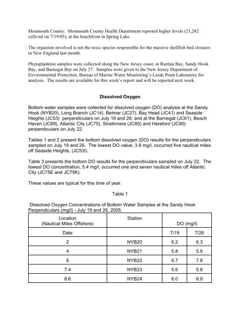
Monmouth County. Monmouth County Health Department reported higher levels (21,282<br />
cells/ml on 7/19/05), at the beachfront in Spring Lake.<br />
The organism involved is not the toxic species responsible for the massive shellfish bed closures<br />
in New England last month.<br />
Phytoplankton samples were collected along the New Jersey coast, in Raritan Bay, Sandy Hook<br />
Bay, and Barnegat Bay on July 27. Samples were given to the New Jersey Department of<br />
Environmental Protection, Bureau of Marine Water Monitoring’s Leeds Point Laboratory for<br />
analysis. The results are available for this week’s report and will be reported next week.<br />
Dissolved Oxygen<br />
Bottom water samples were collected for dissolved oxygen (DO) analysis at the Sandy<br />
Hook (NYB20), Long Branch (JC14), Belmar (JC27), Bay Head (JC41) and Seaside<br />
Heights (JC53) perpendiculars on July 19 and 26; and at the Barnegat (JC61), Beach<br />
Haven (JC69), Atlantic City (JC75), Strathmere (JC85) and Hereford (JC90)<br />
perpendiculars on July 22.<br />
Tables 1 and 2 present the bottom dissolved oxygen (DO) results for the perpendiculars<br />
sampled on July 19 and 26. The lowest DO value, 3.8 mg/l, occurred five nautical miles<br />
off Seaside Heights, (JC53I).<br />
Table 3 presents the bottom DO results for the perpendiculars sampled on July 22. The<br />
lowest DO concentration, 5.4 mg/l, occurred one and seven nautical miles off Atlantic<br />
City (JC75E and JC75K).<br />
These values are typical for this time of year.<br />
Table 1<br />
Dissolved Oxygen Concentrations of Bottom Water Samples at the Sandy Hook<br />
Perpendiculars (mg/l) - July 19 and 26, 2005.<br />
Location<br />
(Nautical Miles Offshore)<br />
Station<br />
DO (mg/l)<br />
Date 7/19 7/26<br />
2 NYB20 6.2 6.3<br />
4 NYB21 5.8 5.9<br />
6 NYB22 6.7 7.8<br />
7.4 NYB23 5.6 5.8<br />
8.6 NYB24 6.0 6.9