
You also want an ePaper? Increase the reach of your titles
YUMPU automatically turns print PDFs into web optimized ePapers that Google loves.
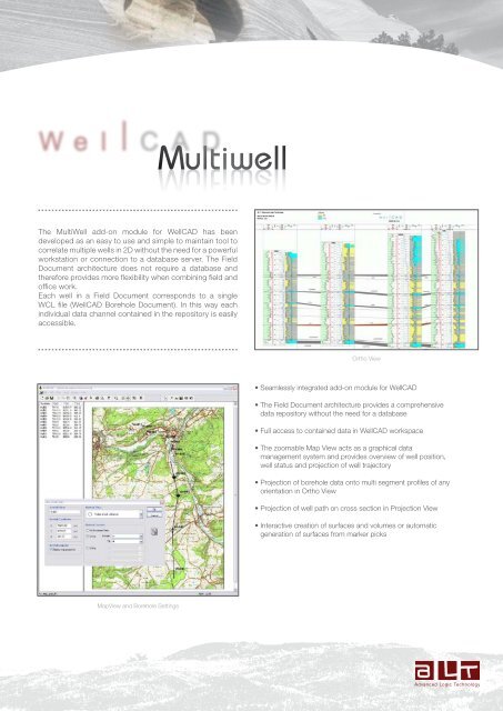
<strong>Multiwell</strong> <strong>Multiwell</strong><br />
The MultiWell add-on module for WellCAD has been<br />
developed as an easy to use and simple to maintain tool to<br />
correlate multiple wells in 2D without the need for a powerful<br />
workstation or connection to a database server. The Field<br />
Document architecture does not require a database and<br />
therefore provides more flexibility when combining field and<br />
office work.<br />
Each well in a Field Document corresponds to a single<br />
WCL file (WellCAD Borehole Document). In this way each<br />
individual data channel contained in the repository is easily<br />
accessible.<br />
Ortho View<br />
• Seamlessly integrated add-on module for WellCAD<br />
• The Field Document architecture provides a comprehensive<br />
data repository without the need for a database<br />
• Full access to contained data in WellCAD workspace<br />
• The zoomable Map View acts as a graphical data<br />
management system and provides overview of well position,<br />
well status and projection of well trajectory<br />
• Projection of borehole data onto multi segment profiles of any<br />
orientation in Ortho View<br />
• Projection of well path on cross section in Projection View<br />
• Interactive creation of surfaces and volumes or automatic<br />
generation of surfaces from marker picks<br />
MapView and Borehole Settings
Map View<br />
The Map View allows the loading and positioning of wells on<br />
a map. Cross sections (projection profiles) can be inserted<br />
interactively by the user. Profiles do not have to interconnect<br />
the wells but can be of any orientation and may consist of<br />
multiple differently oriented segments. Finally the user selects<br />
which wells project their data onto the cross sections before<br />
proceeding to the Ortho View.<br />
MapView with 80 wells showing multiple profiles (cross sections)<br />
Ortho View<br />
Profile and well<br />
selection<br />
In Ortho View the data of each well is displayed in a vertical<br />
column. The distance between the displayed well sticks is<br />
proportional to the distance between the projections of the<br />
boreholes on the cross section plane. The choice of logs<br />
displayed in each well stick and their layout can be chosen<br />
by the user. Surfaces can either be inserted interactively or<br />
automatically and volumes filled with the same lithology patterns<br />
used in lithology logs. Options to change vertical and horizontal<br />
scales, to zoom in/out, to flatten a reference surface, to add<br />
annotations and header information complement the Ortho<br />
Projection View<br />
OrthoView<br />
Individual well stick options<br />
The Projection View displays the projection of the borehole path<br />
onto the cross section plane using the well’s trajectory channels.<br />
Information from a Lithology Log can be superimposed on the<br />
well stick as different colors. Volume fills and surfaces are<br />
displayed as inserted in the Ortho View workspace or can be<br />
inserted interactively. Options to change vertical and horizontal<br />
scales, to zoom in/out, to flatten a reference surface, to add<br />
annotations and header information are applicable to the<br />
Projection View as well.<br />
Projection View<br />
Detailed surface settings<br />
The specifications are not contractual and are subject to modification without notice.<br />
Zoning de Solupla Bât A - route de Niederpallen - L-8506 Redange - Luxembourg - Tél. + 352 23 649 289<br />
36th Floor, Menara Maxis - Kuala Lumpur City Centre - 50088 Kuala Lumpur - Malaysia - Tel. + 60 3 2615 7261