pre-Driving Maritime workbook - North Steyne SLSC
pre-Driving Maritime workbook - North Steyne SLSC
pre-Driving Maritime workbook - North Steyne SLSC

You also want an ePaper? Increase the reach of your titles
YUMPU automatically turns print PDFs into web optimized ePapers that Google loves.
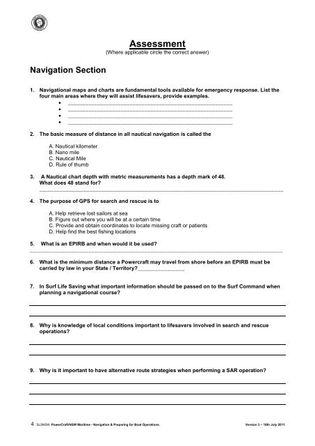
Assessment<br />
(Where applicable circle the correct answer)<br />
Navigation Section<br />
1. Navigational maps and charts are fundamental tools available for emergency response. List the<br />
four main areas where they will assist lifesavers, provide examples.<br />
• ________________________________________________________<br />
• ________________________________________________________<br />
• ________________________________________________________<br />
• ________________________________________________________<br />
2. The basic measure of distance in all nautical navigation is called the<br />
A. Nautical kilometer<br />
B. Nano mile<br />
C. Nautical Mile<br />
D. Rule of thumb<br />
3. A Nautical chart depth with metric measurements has a depth mark of 48.<br />
What does 48 stand for?<br />
___________________________________________________________________________________<br />
4. The purpose of GPS for search and rescue is to<br />
A. Help retrieve lost sailors at sea<br />
B. Figure out where you will be at a certain time<br />
C. Provide and obtain coordinates to locate missing craft or patients<br />
D. Help find the best fishing locations<br />
5. What is an EPIRB and when would it be used?<br />
______________________________________________________________________________________<br />
6. What is the minimum distance a Powercraft may travel from shore before an EPIRB must be<br />
carried by law in your State / Territory?________________<br />
7. In Surf Life Saving what important information should be passed on to the Surf Command when<br />
planning a navigational course?<br />
8. Why is knowledge of local conditions important to lifesavers involved in search and rescue<br />
operations?<br />
9. Why is it important to have alternative route strategies when performing a SAR operation?<br />
4 SLSNSW PowerCraft/NSW <strong>Maritime</strong> - Navigation & Preparing for Boat Operations. Version 3 – 18th July 2011