VTS Brochure - Marine Exchange of Southern California
VTS Brochure - Marine Exchange of Southern California
VTS Brochure - Marine Exchange of Southern California

Create successful ePaper yourself
Turn your PDF publications into a flip-book with our unique Google optimized e-Paper software.
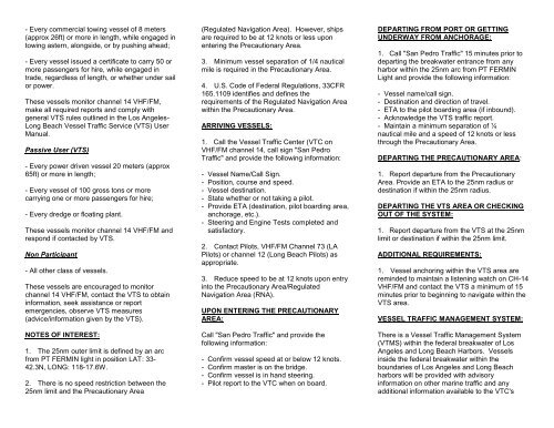
- Every commercial towing vessel <strong>of</strong> 8 meters<br />
(approx 26ft) or more in length, while engaged in<br />
towing astern, alongside, or by pushing ahead;<br />
- Every vessel issued a certificate to carry 50 or<br />
more passengers for hire, while engaged in<br />
trade, regardless <strong>of</strong> length, or whether under sail<br />
or power.<br />
These vessels monitor channel 14 VHF/FM,<br />
make all required reports and comply with<br />
general <strong>VTS</strong> rules outlined in the Los Angeles-<br />
Long Beach Vessel Traffic Service (<strong>VTS</strong>) User<br />
Manual.<br />
Passive User (<strong>VTS</strong>)<br />
- Every power driven vessel 20 meters (approx<br />
65ft) or more in length;<br />
- Every vessel <strong>of</strong> 100 gross tons or more<br />
carrying one or more passengers for hire;<br />
- Every dredge or floating plant.<br />
These vessels monitor channel 14 VHF/FM and<br />
respond if contacted by <strong>VTS</strong>.<br />
Non Participant<br />
- All other class <strong>of</strong> vessels.<br />
These vessels are encouraged to monitor<br />
channel 14 VHF/FM, contact the <strong>VTS</strong> to obtain<br />
information, seek assistance or report<br />
emergencies, observe <strong>VTS</strong> measures<br />
(advice/information given by the <strong>VTS</strong>).<br />
NOTES OF INTEREST:<br />
1. The 25nm outer limit is defined by an arc<br />
from PT FERMIN light in position LAT: 33-<br />
42.3N, LONG: 118-17.6W.<br />
2. There is no speed restriction between the<br />
25nm limit and the Precautionary Area<br />
(Regulated Navigation Area). However, ships<br />
are required to be at 12 knots or less upon<br />
entering the Precautionary Area.<br />
3. Minimum vessel separation <strong>of</strong> 1/4 nautical<br />
mile is required in the Precautionary Area.<br />
4. U.S. Code <strong>of</strong> Federal Regulations, 33CFR<br />
165.1109 identifies and defines the<br />
requirements <strong>of</strong> the Regulated Navigation Area<br />
within the Precautionary Area.<br />
ARRIVING VESSELS:<br />
1. Call the Vessel Traffic Center (VTC on<br />
VHF/FM channel 14, call sign "San Pedro<br />
Traffic" and provide the following information:<br />
- Vessel Name/Call Sign.<br />
- Position, course and speed.<br />
- Vessel destination.<br />
- State whether or not taking a pilot.<br />
- Provide ETA (destination, pilot boarding area,<br />
anchorage, etc.).<br />
- Steering and Engine Tests completed and<br />
satisfactory.<br />
2. Contact Pilots, VHF/FM Channel 73 (LA<br />
Pilots) or channel 12 (Long Beach Pilots) as<br />
appropriate.<br />
3. Reduce speed to be at 12 knots upon entry<br />
into the Precautionary Area/Regulated<br />
Navigation Area (RNA).<br />
UPON ENTERING THE PRECAUTIONARY<br />
AREA:<br />
Call "San Pedro Traffic" and provide the<br />
following information:<br />
- Confirm vessel speed at or below 12 knots.<br />
- Confirm master is on the bridge.<br />
- Confirm vessel is in hand steering.<br />
- Pilot report to the VTC when on board.<br />
DEPARTING FROM PORT OR GETTING<br />
UNDERWAY FROM ANCHORAGE:<br />
1. Call "San Pedro Traffic" 15 minutes prior to<br />
departing the breakwater entrance from any<br />
harbor within the 25nm arc from PT FERMIN<br />
Light and provide the following information:<br />
- Vessel name/call sign.<br />
- Destination and direction <strong>of</strong> travel.<br />
- ETA to the pilot boarding area (if inbound).<br />
- Acknowledge the <strong>VTS</strong> traffic report.<br />
- Maintain a minimum separation <strong>of</strong> ¼<br />
nautical mile and a speed <strong>of</strong> 12 knots or less<br />
through the Precautionary Area.<br />
DEPARTING THE PRECAUTIONARY AREA:<br />
1. Report departure from the Precautionary<br />
Area. Provide an ETA to the 25nm radius or<br />
destination if within the 25nm radius.<br />
DEPARTING THE <strong>VTS</strong> AREA OR CHECKING<br />
OUT OF THE SYSTEM:<br />
1. Report departure from the <strong>VTS</strong> at the 25nm<br />
limit or destination if within the 25nm limit.<br />
ADDITIONAL REQUIREMENTS:<br />
1. Vessel anchoring within the <strong>VTS</strong> area are<br />
reminded to maintain a listening watch on CH-14<br />
VHF/FM and contact the <strong>VTS</strong> a minimum <strong>of</strong> 15<br />
minutes prior to beginning to navigate within the<br />
<strong>VTS</strong> area.<br />
VESSEL TRAFFIC MANAGEMENT SYSTEM:<br />
There is a Vessel Traffic Management System<br />
(VTMS) within the federal breakwater <strong>of</strong> Los<br />
Angeles and Long Beach Harbors. Vessels<br />
inside the federal breakwater within the<br />
boundaries <strong>of</strong> Los Angeles and Long Beach<br />
harbors will be provided with advisory<br />
information on other marine traffic and any<br />
additional information available to the VTC's
that may affect vessel traffic safety within their<br />
sectors. The Los Angeles Sector is operated by<br />
the Los Angeles Pilot Station. Call Sign: "LA<br />
PILOTS". Traffic advisories are obtained on<br />
channel 73 VHF/FM. The Long Beach Sector is<br />
operated by the Jacobsen Pilot Service. Call<br />
Sign "LONG BEACH PILOTS". Traffic advisories<br />
are obtained on channel 74 VHF/FM.<br />
<strong>VTS</strong> USER MANUAL:<br />
The <strong>VTS</strong> User Manual (revised June 01, 2013)<br />
may be viewed or obtained by visiting our<br />
website at www.mxsocal.org, or by contacting<br />
the <strong>VTS</strong> Los Angeles/Long Beach 24 hour<br />
number at (310) 832-6411. We encourage all<br />
interested parties to visit the USCG/<strong>Marine</strong><br />
<strong>Exchange</strong> Vessel Traffic Center, the Los<br />
Angeles Pilot Station and Long Beach Pilot<br />
Station. We also encourage suggestions for<br />
improvements to the <strong>VTS</strong> USER MANUAL or to<br />
<strong>VTS</strong> procedures. Suggestions may be mailed<br />
to:<br />
USCG/MX Vessel Traffic Center<br />
P.O.Box 1949<br />
San Pedro, CA 90733-1949; USA<br />
Phone: (310) 519-3126 (administration <strong>of</strong>fice)<br />
(310) 832-6411 (24 hour ops center)<br />
(310) 833-7051 (fax)<br />
World Wide Web: www.mxsocal.org<br />
VOLUNTARY WESTERN TRAFFIC LANES<br />
To address the safety concerns created by<br />
increased traffic south <strong>of</strong> the channel Islands, on<br />
October 6, 2009, the Los Angeles/Long Beach<br />
Harbor Safety Committee (LA/LB HSC)<br />
endorsed voluntary traffic lanes in the area<br />
south <strong>of</strong> the Channel Islands (referenced herein<br />
as “voluntary western traffic lanes”) The LA/LB<br />
HSC developed these lanes as a voluntary<br />
measure to promote vessel safety.<br />
Since the new voluntary western traffic lanes are<br />
not an IMO approved traffic separation scheme,<br />
the International regulations for Avoiding<br />
Collisions at Sea (COLREGS) Rule 10 does not<br />
apply.<br />
<strong>Marine</strong>s should exercise due caution when<br />
choosing to operate south <strong>of</strong> the Channel<br />
Islands and within the voluntary western traffic<br />
lanes. Description and further details may be<br />
found at our website at www.mxsocal.org or as<br />
listed in U.S.C.G. Local Notice to <strong>Marine</strong>rs<br />
district: 11, Week 17/13, also in U.S.C.G. Sector<br />
Los Angeles – Long Beach <strong>Marine</strong> Safety<br />
Information bulletin 11-09.<br />
SANTA BARBARA CHANNEL TRAFFIC<br />
SEPARTATION SCHEME AMENDMENT<br />
The International Maritime Organization (IMO) is<br />
amending the Traffic Separation Scheme (TSS)<br />
in the Santa Barbara Channel and the approach<br />
to the ports <strong>of</strong> Los Angeles/Long Beach,<br />
effective June 1, 2013. The TSS amendment will<br />
reduce the width <strong>of</strong> the separation zone from 2<br />
nautical miles (nm) to 1 nm by shifting the<br />
inbound lane shoreward and away from known<br />
whale concentrations. The outbound lane will<br />
remain unchanged in the current location.<br />
Narrowing the separation zone is expected to<br />
reduce co-occurrence <strong>of</strong> ships and whales while<br />
maintaining navigation safety. The IMO<br />
approved coordinates and graphic depicting the<br />
enclosed changes are provided in our User<br />
Manual located at our website or as listed in<br />
U.S.C.G. Local Notice To <strong>Marine</strong>rs, District: 11,<br />
Week: 17/13.<br />
VESSEL TRAFFIC SERVICE<br />
LOS ANGELES-LONG BEACH<br />
(Updated: June 01, 2013)<br />
SERVING THE SOUTHERN<br />
CALIFORNIA MARITIME INDUSTRY<br />
BY FACILITATING SAFE, EFFICIENT<br />
AND RELIABLE MARINE<br />
TRANSPORTATION.<br />
VESSEL TRAFFIC SERVICE LOS ANGELES-<br />
LONG BEACH (<strong>VTS</strong>)<br />
CALL SIGN: "SAN PEDRO TRAFFIC"<br />
Vessel Traffic Service Los Angeles-Long Beach<br />
(<strong>VTS</strong>) is in operation on the approaches to Los<br />
Angeles and Long Beach Harbors. Operated<br />
jointly by the U.S. Coast Guard and the <strong>Marine</strong><br />
<strong>Exchange</strong> <strong>of</strong> <strong>Southern</strong> <strong>California</strong>, the <strong>VTS</strong><br />
provides vessel operators with advanced<br />
information <strong>of</strong> other reported marine traffic and<br />
any additional information, advice, and<br />
recommendations which may affect vessel<br />
safety within the <strong>VTS</strong> area.<br />
The following participation requirements apply:<br />
Active User (VMRS) Vessel Movement<br />
Reporting System:<br />
- Every power driven vessel <strong>of</strong> 40 meters<br />
(approx 131ft) or more in length, while<br />
navigating;