

Structural geology of southeastern Illinois and vicinity - University of ...
Structural geology of southeastern Illinois and vicinity - University of ...
Structural geology of southeastern Illinois and vicinity - University of ...

Create successful ePaper yourself
Turn your PDF publications into a flip-book with our unique Google optimized e-Paper software.
epartrnent <strong>of</strong> Energy <strong>and</strong> Natural Resources<br />
<strong>Illinois</strong> State Geological Survey<br />
Circular 538<br />
1987
Graphics: S<strong>and</strong>ra Stecyk<br />
Plates: Pamella Foster<br />
Cover: John Moss<br />
Nelson, W. John<br />
<strong>Structural</strong> <strong>geology</strong> <strong>of</strong> <strong>southeastern</strong> <strong>Illinois</strong> <strong>and</strong> <strong>vicinity</strong> 1<br />
W. John Nelson <strong>and</strong> Donald K. Lumm. -Champaign, lL : <strong>Illinois</strong><br />
State Geological Survey, 1987.<br />
70 p. : 2 plates ; 28 cm. - (<strong>Illinois</strong>-Geological Survey. Circular<br />
; 538)<br />
Condensed <strong>and</strong> revised version <strong>of</strong> ISGS ContractIGrant Report<br />
1982-2.<br />
1. Geology, <strong>Structural</strong>-<strong>Illinois</strong>-Southeastern. 2. Faults-<strong>Illinois</strong>,<br />
Southeastern. 3. Rough Creek-Shawneetown Fault System. I.<br />
Title. II. Lumm, Donald K. Ill. Series.<br />
Printed by authority <strong>of</strong> the State <strong>of</strong> lllinois/198 7/l5OO
STRUCTURAL GEOLOGY<br />
ILLINOIS AND VICINITY<br />
W. John Nelson <strong>and</strong> Donald K. Lumm<br />
Circular 538<br />
1987<br />
ILLINOIS STATE GEOLOGICAL SURVEY<br />
Morris W. Leighton, Chief<br />
Natural Resources Building<br />
615 East Peabody Drive<br />
Champaign, <strong>Illinois</strong> 61820
ABSTRACT 1<br />
INTRODUCTION 3<br />
METHOD OF STUDY 6<br />
STRATIGRAPHY 8<br />
Precambrian rocks 8<br />
Cambrian System 9<br />
Ordovician System 11<br />
Silurian System 11<br />
Devonian System 13<br />
M ississippian System 13<br />
Pennsylvanian System 17<br />
Permian System 21<br />
Tertiary System 21<br />
Quaternary System 23<br />
STRUCTURAL GEOLOGY 25<br />
Rough Creek-Shawneetown Fault System 25<br />
Cottage Grove Fault System 46<br />
Wabash Valley Fault System 47<br />
Fluorspar Area Fault Complex 49<br />
Pennyrile Fault System 54<br />
TECTONIC HISTORY 56<br />
MODERN STRESS FIELD AND SEISMICITY 58<br />
Modern stress field 58<br />
Seismicity 61<br />
BIBLIOGRAPHY 65<br />
FIGURES<br />
1. Precambrian rift zones in northern Mississippi Embayment 3<br />
2. Regional tectonic setting <strong>of</strong> study area 4<br />
3. Locations <strong>of</strong> deep wells 9<br />
4. Generalized stratigraphic column for study region 12<br />
5. Narrow fault slice at Horseshoe Quarry 13<br />
6. Stratigraphic column <strong>of</strong> Chesterian Series 14<br />
7. Stratigraphic column <strong>of</strong> Pennsylvanian System 18<br />
8. Maumee Flood deposits <strong>and</strong> faults, Shawneetown Quadrangle 22<br />
9. <strong>Structural</strong> features <strong>of</strong> study region 26<br />
10. Rough Creek-Shawneetown Fault System 28<br />
11. Cross sections <strong>of</strong> Rough Creek Fault System 32<br />
12. Fault in underground workings <strong>of</strong> Camp 1 Mine 34<br />
13. "Flower structures" produced by upthrust-faulting 37<br />
14. Paleochannels crossing Rough Creek-Shawneetown Fault System 38<br />
15. Sketch showing results <strong>of</strong> experiments simulating vertical uplift <strong>of</strong> rigid basement block 39<br />
16. Cross section <strong>of</strong> Boothia Uplift 40<br />
17. Development <strong>of</strong> Rough Creek-Shawneetown Fault System 41<br />
18. Interpretation <strong>of</strong> structure in Margaret Karsch well 42<br />
19. Paleoslump in highwall <strong>of</strong> Eagle Surface Mine 43<br />
20. Thrust fault in highwall <strong>of</strong> Eagle Surface Mine 44<br />
21. "Horseback" in Camp 11 Mine 45<br />
22. Fanlike fault pattern north <strong>of</strong> Shawneetown Fault Zone 48<br />
23. Fluorspar Area Fault Complex 50<br />
24. Igneous intrusions <strong>and</strong> diatremes 52<br />
25. Development <strong>of</strong> Rough Creek <strong>and</strong> Pennyrile Fault Systems 55<br />
26. Tectonic events <strong>of</strong> late Pennsylvanian-early Permian time 57<br />
27. Features <strong>and</strong> measurements indicative <strong>of</strong> modern stress field 59<br />
28. Epicenters <strong>of</strong> earthquakes in Mississippi Valley 62<br />
29. Diagram showing faults that could be formed or reactivated in stress field oriented east-west, with<br />
principal compressive stress horizontal 63<br />
TABLE<br />
1. Deep wells penetrating sub-Mississippian formation in <strong>and</strong> near study area 10<br />
PLATES<br />
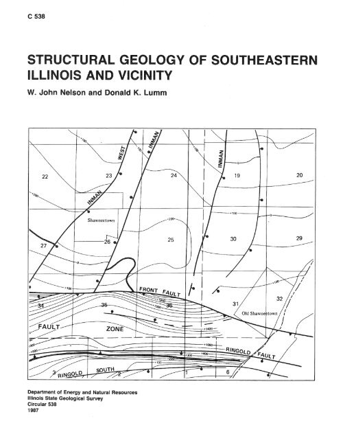
1. (a) Simplified geologic map <strong>of</strong> Rudement, Equality, <strong>and</strong> Shawneetown Quadrangles (b) Geologic cross sections<br />
2. <strong>Structural</strong> contour map <strong>of</strong> the Springfield (No. 5) Coal Member in the Shawneetown Fault Zone <strong>and</strong> <strong>vicinity</strong>,<br />
<strong>southeastern</strong> <strong>Illinois</strong>
The <strong>Illinois</strong> State Geological Survey recently published three multicolored 7%-minute<br />
geologic quadrangle maps:<br />
IGQ-1 : Shawneetown Quadrangle<br />
IGQ-2: Equality Quadrangle<br />
IGQ-3: Rudement Quadrangle.<br />
These maps, prepared by W. John Nelson <strong>and</strong> Donald K. Lumm, can be used to supplement<br />
plates I <strong>and</strong> 2, which accompany this circular; they provide a detailed picture <strong>of</strong><br />
the Shawneetown Fault Zone, which extends westward from just south <strong>of</strong> Old Shawneetown<br />
through all three quadrangles.<br />
The U.S. Geological Survey partially funded preparation <strong>and</strong> printing <strong>of</strong> the maps<br />
through its Cooperative Geologic Mapping Program (COGEOMAP). Lumm received financial<br />
support from the COGEOMAP program also during preparation <strong>of</strong> the maps.<br />
Each <strong>of</strong> the three maps contains a geologic column, a geologic cross section, <strong>and</strong> descriptive<br />
material on the structural <strong>and</strong> economic <strong>geology</strong> <strong>of</strong> the quadrangle.
ABSTRACT<br />
The structural history <strong>of</strong> <strong>southeastern</strong> l llinois <strong>and</strong> adjacent parts <strong>of</strong> southwestern Indiana<br />
<strong>and</strong> western Kentucky is long <strong>and</strong> complex. Numerous fau It systems developed under<br />
different stress regimes acting from late Precambrian through at least late Cretaceous time.<br />
The current stress field, E-W to ENE-WSW horizontal compression, differs from any known<br />
ancient stress field. Lateral tension in late Precambrian <strong>and</strong> early Cambrian time produced<br />
a deep, fault-bounded trough, the Reelfoot Rift, along the present Mississippi Embayment.<br />
An east-trending branch <strong>of</strong> this trough across southern <strong>Illinois</strong> <strong>and</strong> western Kentucky is<br />
called the Rough Creek Graben. Reactivation <strong>of</strong> these ancient rift zones produced the<br />
modern bedrock fault systems. The Cottage Grove <strong>and</strong> Rough Creek-Shawneetown Fault<br />
Systems follow the northern wall <strong>of</strong> the Rough Creek Graben, <strong>and</strong> the Pennyrile Fault<br />
System follows the southern wall. The Wabash Valley <strong>and</strong> Fluorspar Area Fault Systems<br />
follow ancient lines <strong>of</strong> weakness in the Reelfoot Rift.<br />
The Rough Creek-Shawneetown Fault System is a braided zone <strong>of</strong> steeply dipping<br />
faults. The master fault is a high-angle reverse fault inclined to the south. Net vertical<br />
displacement across the zone is slight, but many slices <strong>of</strong> older rocks are upthrown within<br />
the fault zone. Strata north <strong>of</strong> the zone dip gently, but beds to the south dip steeply into<br />
the Eagle Valley <strong>and</strong> Moorman Synclines. We propose that the fault system formed through<br />
essentially vertical uplift <strong>of</strong> the southern block, <strong>and</strong> subsequent return <strong>of</strong> the block to<br />
approximately its original position. Major movements were post-Pennsylvanian <strong>and</strong> probably<br />
pre- late Cretaceous.<br />
The Cottage Grove Fault System extends westward from, but does not directly connect<br />
with, the Rough Creek-Shawneetown Fau It System. The Cottage Grove is a right-lateral<br />
fault system. Included peridotite intrusions show the age <strong>of</strong> faulting to be latest Pennsylvanian<br />
to early Permian.<br />
The Wabash Valley Fault System comprises north- to northeast- trending high-angle<br />
normal faults that developed under horizontal extension. The time <strong>of</strong> faulting is not established,<br />
but contemporaneity to the Cottage Grove Fault System is suggested.<br />
The F luorspar Area Fault Complex includes ultramafic dikes <strong>and</strong> diatremes, radiometrically<br />
dated as early Permian, radiating from the circular uplift <strong>of</strong> Hicks Dome, a<br />
crypto-volcanic feature. Cross-cutting these are numerous high-angle faults, mostly normal<br />
but having some reverse <strong>and</strong> strike-slip displacements. Multiple <strong>and</strong> recurrent episodes <strong>of</strong><br />
tectonism <strong>and</strong> mineralization, from late Pennsylvanian through late Cretaceous time, are<br />
indicated.<br />
The Pennyrile Fault System <strong>of</strong> en echelon normal faults apparently marks the hinge<br />
line <strong>of</strong> the southern block <strong>of</strong> the Rough Creek-Shawneetown Fault System. The action <strong>of</strong><br />
the block was comparable to that <strong>of</strong> an obliquely hung trap door.<br />
No Quaternary faulting can be documented; however, the modern horizontal-compressive<br />
stress field is strongly indicated by focal mechanisms <strong>of</strong> earthquakes, hydr<strong>of</strong>racturing<br />
experiments, in situ stress tests, <strong>and</strong> patterns <strong>of</strong> joints <strong>and</strong> ground failures observed in underground<br />
mines. Small north-trending thrust faults, also observed in mines, may be relatively<br />
recent features. Some fau Its in the study area are correctly oriented to reactivate under<br />
the modern stress regime, but further evaluation <strong>of</strong> seismicity versus bedrock faulting is<br />
beyond the scope <strong>of</strong> this report.<br />
STRUCTURAL GEOLOGY OF SOUTHEASTERN ILLINOIS AND VICINITY
ACKNOWLEDGMENTS<br />
This Circular is a condensed <strong>and</strong> revised version <strong>of</strong> ISGS Contract/Grant Report 1984-2<br />
(Nelson <strong>and</strong> Lumm, 1984). The research for that report was carried out under a grant from<br />
the U.S. Nuclear Regulatory Commission (NRC-04-81-016, grant no. 1-5-24465). The goal<br />
<strong>of</strong> the study was to determine the nature, extent, age, <strong>and</strong> origin <strong>of</strong> faults in <strong>southeastern</strong><br />
<strong>Illinois</strong> <strong>and</strong> adjacent parts <strong>of</strong> Kentucky <strong>and</strong> Indiana, <strong>and</strong> to work out the tectonic history <strong>of</strong><br />
the region as an aid in assessing the potential for earthquakes along these faults. We worked<br />
as part <strong>of</strong> the NRC's New Madrid Study Group, which was composed <strong>of</strong> geologists, geophysicists,<br />
<strong>and</strong> seismologists from numerous research institutions in east-central United<br />
States. The overall goal <strong>of</strong> the New Madrid Study Group was to better underst<strong>and</strong> <strong>and</strong>, if<br />
possible, predict seismicity, particularly as it affects nuclear facilities, within a 200-mile<br />
radius <strong>of</strong> New Madrid, Missouri.<br />
2 ILLINOIS STATE GEOLOGICAL SURVEY CIRCULAR 538
INTRODUCTION<br />
Purpose <strong>and</strong> scope <strong>of</strong> report<br />
During the winter <strong>of</strong> 181 1-1 2, the central Mississippi Valley was shaken by one <strong>of</strong> the<br />
greatest series <strong>of</strong> earthquakes ever felt in North America. Centered near the pioneer village<br />
<strong>of</strong> New Madrid, Missouri, the quakes were felt through most <strong>of</strong> the eastern United States.<br />
They rang church bells in Richmond, Virginia, <strong>and</strong> threw down chimneys in Cincinnati<br />
<strong>and</strong> St. Louis. Devastation was almost total in the epicentral region. According to contemporary<br />
accounts the ground rose <strong>and</strong> fell like waves at sea, tearing open fissures, snapping<br />
trees, <strong>and</strong> triggering l<strong>and</strong>slides; waterfalls formed in the Mississippi River, boats were sunk,<br />
<strong>and</strong> isl<strong>and</strong>s disappeared. Whole sections <strong>of</strong> the flood plain were uplifted as other areas subsided,<br />
forming swamps <strong>and</strong> lakes such as Reelfoot Lake, where upl<strong>and</strong> forests had formerly<br />
grown. The loss <strong>of</strong> life, fortunately, was slight (most fatalities apparently were caused by<br />
drownings on the river) because the area was thinly populated, <strong>and</strong> the houses (mostly log<br />
cabins) withstood the shocks long enough for the inhabitants to get outside (Fuller, 191 2).<br />
Were such earthquakes to reoccur today, the casualties <strong>and</strong> destruction <strong>of</strong> property could<br />
be appalling.<br />
Geologists <strong>and</strong> geophysicists have since established that the New Madrid area is a zone<br />
<strong>of</strong> ongoing seismic activity. Within a recent 4-year period, Stauder (1982) recorded 731<br />
tremors, <strong>of</strong> which several were strong enough to cause localized damage. These tremors were<br />
attributed to a buried fault zone known as the Reelfoot Rift (fig. 1). The rift apparently<br />
FIGURE 1. Precambrian rift zones in northern Mississippi Embayment.<br />
STRUCTURAL GEOLOGY OF SOUTHEASTERN ILLINOIS AND VICINITY
is an ancient zone <strong>of</strong> weakness that has been active throughout much <strong>of</strong> geologic time. The<br />
nature <strong>and</strong> extent <strong>of</strong> the Reelfoot Rift thus is a matter <strong>of</strong> pressing concern to inhabitants<br />
<strong>of</strong> the central Mississippi Valley.<br />
Occasional earthquakes occur in <strong>Illinois</strong>, particularly in the southern portion. While<br />
none to date has been truly destructive, several have damaged property <strong>and</strong> alarmed the<br />
population. People are naturally concerned about these quakes <strong>and</strong> their pattern <strong>of</strong> reoccurrence.<br />
Is southern <strong>Illinois</strong> in danger <strong>of</strong> cataclysmic shocks comparable to the New Madrid<br />
events?<br />
The bedrock <strong>of</strong> southern <strong>Illinois</strong> is riddled with faults. A regional map (fig. 2) reveals<br />
two major trends <strong>of</strong> fractures: east-west <strong>and</strong> northeast-southwest. The Cottage Grove Fault<br />
System <strong>and</strong> Shawneetown Fault Zone cross <strong>Illinois</strong> from west to east; the Rough Creek<br />
Fault System continues eastward into Kentucky. North <strong>of</strong> the Shawneetown Fault Zone,<br />
the Wabash Valley Fault System extends north-northeastward along the I llinois-Indiana<br />
boundary, while to the south the multitudinous fractures <strong>of</strong> the Fluorspar Area Fault Complex<br />
project-in seemingly ominous fashion-directly toward the Reelfoot Rift <strong>and</strong> New<br />
Madrid. Little wonder, then, that some geologists have assumed the worst. For example,<br />
Heyl (1972) labeled the combined Fluorspar Area Fault Complex-Wabash Valley Fault<br />
System as the "New Madrid Fault Zone"--implying that all <strong>of</strong> this zone is susceptible to<br />
catastrophic earthquakes. The Shawneetown Fault Zone also is said to be active (Heyl <strong>and</strong><br />
Brock, 1961; Heyl et al., 1965).<br />
To aid in assessing the seismic risk <strong>of</strong> southern I llinois, we conducted this study investigating<br />
the nature; extent, age, origin, <strong>and</strong> history <strong>of</strong> faulting. Specific goals were to deter-<br />
St. Louis<br />
ILLINOIS BASIN - /. vincennes<br />
\<br />
m Mt. Vernon<br />
ClNClNNAT<br />
\<br />
DOME<br />
Bowling Green<br />
Nashville<br />
NASHVILLE<br />
DOME<br />
FIGURE 2. Regional tectonic setting <strong>of</strong> study area. Stippled area, showing region where detailed mapping was done,<br />
includes the Rudement, '~~ualit~, <strong>and</strong> Shawneetown Quadrangles.<br />
4 l LLlNOlS STATE GEOLOGICAL SURVEY CIRCULAR 538
mine whether the Fluorspar Area Fault Complex connects with the Wabash Valley Fault<br />
System, <strong>and</strong> whether the Shawneetown Fault Zone joins the Cottage Grove Fault System.<br />
We focused our attention on <strong>southeastern</strong> Saline <strong>and</strong> south-central Gallatin Counties,<br />
where all <strong>of</strong> these fracture zones converge. Because no detailed studies <strong>of</strong> structural <strong>geology</strong><br />
had been made in this area for more than 50 years despite the concern about earthquakes,<br />
our first step was to map the region in as much detail as newly available data would allow.<br />
Geographic setting<br />
Our area <strong>of</strong> immediate interest comprises the Rudement, Equality, <strong>and</strong> Shawneetown<br />
USGS quadrangles (IGQ-1, 2, 3) in <strong>southeastern</strong> Saline <strong>and</strong> southern Gallatin Counties,<br />
<strong>Illinois</strong> (fig. 2). The three quadrangles form a rectangle approximately 8% miles north to<br />
south by 20 miles east to west. The easternmost quadrangle, Shawneetown, includes the<br />
Ohio River <strong>and</strong> a sinall area in Kentucky already mapped by Palmer (1976). The study<br />
area includes nearly all <strong>of</strong> the Shawneetown Fault Zone <strong>and</strong> portions <strong>of</strong> the Fluorspar<br />
Area Fault Complex <strong>and</strong> Wabash Valley <strong>and</strong> Cottage Grove Fault Systems that approach<br />
or intersect the Shawneetown Fault Zone.<br />
The Shawneetown Fault Zone marks the boundary between the Central Lowl<strong>and</strong> <strong>and</strong><br />
Interior Low Plateaus physiographic provinces in <strong>southeastern</strong> <strong>Illinois</strong>. The Central Lowl<strong>and</strong>s<br />
lie north <strong>of</strong> the fault zone <strong>and</strong> consist <strong>of</strong> level to gently rolling plains <strong>of</strong> Quaternary glaciolacustrine<br />
<strong>and</strong> alluvial sediments, above which low, isolated bedrock hills rise like isl<strong>and</strong>s.<br />
Elevations <strong>of</strong> the plains range from about 340 to 375 feet above sea level; bedrock isl<strong>and</strong>s<br />
locally reach 550 feet or higher. The lnterior Low Plateaus south <strong>of</strong> the Shawneetown Fault<br />
Zone are rugged, maturely dissected hills mostly composed <strong>of</strong> resistant, massive to thickbedded<br />
lower Pennsylvanian s<strong>and</strong>stone. Maximum elevation in the study area is 923 feet.<br />
Eagle Valley, the elongate lowl<strong>and</strong> south <strong>of</strong> <strong>and</strong> parallel to the fault zone, follows the<br />
structural axis <strong>of</strong> the Eagle Valley Syncline. S<strong>and</strong>stones crop out as cuestas <strong>and</strong> hogbacks<br />
with dip-slopes facing inward, toward Eagle Val ley.<br />
The region has a warm, temperate climate, which promotes rapid weathering <strong>of</strong> bedrock.<br />
Exposures are limited to steep slopes <strong>and</strong> ravines, <strong>and</strong> to artificial excavations such as roadcuts<br />
<strong>and</strong> surface mines. Lowl<strong>and</strong>s are extensively farmed in row crops, but upl<strong>and</strong>s are<br />
mostly wooded. Much <strong>of</strong> the plateau region <strong>of</strong> <strong>southeastern</strong> l l l inois has been incorporated<br />
into the Shawnee National Forest.<br />
Geologic setting<br />
The area under investigation is located near the southern part <strong>of</strong> the <strong>Illinois</strong> Basin (fig. 2).<br />
The Rough Creek-Shawneetown Fault Zone divides the larger <strong>Illinois</strong> Basin into the Fairfield<br />
Basin (north) <strong>and</strong> the Eagle Valley-Moorman Syncline (south). Within the <strong>Illinois</strong><br />
Basin, sedimentary rocks <strong>of</strong> Cambrian through Pennsylvanian age are overlapped by unconsolidated<br />
Quaternary sediments. Bordering the l llinois Basin on the west is the Ozark Uplift,<br />
where Precambrian crystalline rocks locally occur at the surface. The Cincinnati Arch,<br />
with Ordovician rocks exposed along its crest, separates the l llinois Basin from the Appa lachian<br />
Basin to the east. Paleozoic rocks are buried beneath partly lithif ied Cretaceous <strong>and</strong><br />
Tertiary deposits in the Mississippi Embayment, a northward projection <strong>of</strong> the Coastal<br />
Plain Province.<br />
Previous research<br />
The first geologist to explore the study area was Cox (1875). Writing on the <strong>geology</strong> <strong>of</strong><br />
Gallatin County, he remarked on the "axis <strong>of</strong> disturbance or upheaval that crosses it, in an<br />
east <strong>and</strong> west direction." This is, <strong>of</strong> course, the Shawneetown Fault Zone. Cox described<br />
many exposures <strong>of</strong> tilted or fractured strata along the fault; some <strong>of</strong> these outcrops are no<br />
longer accessible for study. Cox's concepts <strong>of</strong> stratigraphy <strong>and</strong> structural <strong>geology</strong> have been<br />
STRUCTURAL GEOLOGY OF SOUTHEASTERN ILLINOIS AND VICINITY 5
evised considerably through the years, but they laid the groundwork for all subsequent<br />
investigations.<br />
By far the most comprehensive examination <strong>of</strong> the area was that <strong>of</strong> Butts (1925). His<br />
report includes a geologic map (scale 1 : 62,500) covering all <strong>of</strong> the Rudement, Equality, <strong>and</strong><br />
Shawneetown Quadrangles, plus the rest <strong>of</strong> the Saline <strong>and</strong> Gallatin Counties south <strong>of</strong> these<br />
quadrangles. Stratigraphy, structural <strong>geology</strong>, <strong>and</strong> economic <strong>geology</strong> are covered in his text.<br />
Butts' discussion <strong>of</strong> faults is rather cursory, but he had only limited surface exposures <strong>and</strong><br />
very few subsurface data from which to work. Butts did not speculate on the origin or<br />
tectonic significance <strong>of</strong> the faults; he limited his remarks to field observations.<br />
The <strong>geology</strong> <strong>of</strong> the <strong>Illinois</strong> fluorspar district was discussed, <strong>and</strong> mapped (at 1 : 24,000)<br />
in three ISGS Circulars (Baxter, Potter, <strong>and</strong> Doyle, 1963; Baxter <strong>and</strong> Desborough, 1965;<br />
<strong>and</strong> Baxter, Desborough, <strong>and</strong> Shaw, 1967). The area covered extends from the southern<br />
edge <strong>of</strong> our mapping area to the Ohio River (I llinois-Kentucky state line). The Fluorspar<br />
Area Fault Complex <strong>and</strong> southern terminus <strong>of</strong> the Shawneetown Fault Zone anti their<br />
relationship to mineralization were treated in detail. In addition, Trace (1974), Hook<br />
(1974), <strong>and</strong> Trace <strong>and</strong> Amos (1984) provided excellent structural overviews <strong>of</strong> the I llinois-<br />
Kentucky Fluorspar District, <strong>and</strong> Klasner (1982) mapped the area where the Shawneetown<br />
Fault Zone joins the Fluorspar Area Fault Complex.<br />
The entire state <strong>of</strong> Kentucky has been mapped geologically on 7.5-minute quadrangles.<br />
Many <strong>of</strong> the geologic quadrangles include cross sections illustrating the structure <strong>of</strong> fault<br />
zones. The Grove Center Quadrangle, immediately east <strong>of</strong> Shawneetown, was mapped by<br />
Palmer (1976).<br />
Geologic quadrangle maps are not available for the region north <strong>and</strong> west <strong>of</strong> the study<br />
area, mostly because the cover <strong>of</strong> Quaternary deposits hides all but a few scattered exposures<br />
<strong>of</strong> bedrock in those quadrangles. Quaternary deposits <strong>of</strong> <strong>Illinois</strong> were mapped by<br />
Lineback et al. (1979).<br />
The Cottage Grove Fault System was mapped (scale about 1 : 100,000) <strong>and</strong> described<br />
in detail by Nelson <strong>and</strong> Krausse (1981). The faults are known from numerous exposures<br />
in underground coal mines <strong>and</strong> also from test drilling. The Wabash Valley Fault System<br />
in Indiana was discussed by Ault et al. (1980) <strong>and</strong> mapped at a scale <strong>of</strong> approximately<br />
1 :31,680 on six separate maps by Tanner, Stellavato, <strong>and</strong> Mackey (1981). Bristol <strong>and</strong><br />
Treworgy (1979) mapped Wabash Valley Faults in <strong>Illinois</strong> <strong>and</strong> discussed the fault system<br />
as a whole.<br />
In addition to these published sources, unpublished manuscripts <strong>and</strong> field notes on file<br />
at the ISGS contain much useful information on our area <strong>of</strong> interest.<br />
METHOD OF STUDY<br />
Field mapping<br />
The entire Rudement, Equality, <strong>and</strong> Shawneetown quadrangles were mapped geologically<br />
(plate 1 ; I GQ-1, 2, 3) for this report. We visited almost every exposure <strong>of</strong> bedrock-natural<br />
<strong>and</strong> artificial-during our surficial mapping. We examined the highwalls <strong>of</strong> all ab<strong>and</strong>oned<br />
strip mines <strong>and</strong> made repeated visits to active mines, since virtually none <strong>of</strong> these mines<br />
existed during the early 1920s when Butts mapped. Mines provide excellent views <strong>of</strong> structural<br />
attitude <strong>of</strong> the rocks; in a number <strong>of</strong> cases, faults are visible in the highwalls.<br />
We used U.S. Geological Survey 7.5-minute quadrangle topographic maps as base maps<br />
in areas having little or no structural complexity; for complexly faulted sections, we enlarged<br />
these maps two to three times. In some places we used a portable altimeter to determine<br />
altitude, especially in strip mines where topography has been altered.<br />
Ground work was supplemented by stereoscopic study <strong>of</strong> aerial photographs taken by<br />
the U.S. Department <strong>of</strong> Agriculture during the 1950s. These summertime photos are not<br />
ideal for geologic interpretation, but in spite <strong>of</strong> the dense vegetation, a number <strong>of</strong> linear<br />
features, interpreted as fau Its, cou Id be detected on the photographs. Many linear features<br />
revealed on aerial photographs are not apparent on the ground or on topographic maps.<br />
6 l LLlNOlS STATE GEOLOGICAL SURVEY CIRCULAR 538
Mapping focused on faults <strong>and</strong> related tectonic structural features, <strong>and</strong> on identification<br />
<strong>of</strong> bedrock-stratigraphic units. Surf icial deposits were mapped in places where they<br />
dominate the l<strong>and</strong>scape <strong>and</strong>/or completely mask the bedrock. For identification <strong>of</strong> surficial<br />
sediments we relied mainly on published work <strong>of</strong> others, primarily Heinrich (1982)<br />
<strong>and</strong> Lineback et al. (1 979).<br />
Subsurface mapping<br />
The structure-contour map <strong>of</strong> the Rudement, Equality, <strong>and</strong> Shawneetown Quadrangles<br />
(plate 2; IGQ-1, 2, 3) is based on logs <strong>of</strong> several thous<strong>and</strong> wells, almost none <strong>of</strong> which were<br />
available to Butts (1925). Most <strong>of</strong> the wells are coal-test borings; also included are roughly<br />
150 tests for oil <strong>and</strong> gas, <strong>and</strong> a few water wells <strong>and</strong> foundation borings. In compiling plate 2,<br />
we also used maps (provided by coal companies) that were based upon thous<strong>and</strong>s <strong>of</strong> drill<br />
holes, spaced as closely as 100 feet apart. Such maps cover a large portion <strong>of</strong> the Eagle<br />
Valley Syncline <strong>and</strong> structurally complex areas near Cottage Grove <strong>and</strong> Equality. Extremely<br />
accurate placement <strong>of</strong> faults <strong>and</strong> igneous intrusions is possible with these maps.<br />
The unequal distribution <strong>of</strong> datum points on plate 2 reflects the mineral economics.<br />
Because coal is found in rocks <strong>of</strong> middle Pennsylvanian age, coal companies have not explored<br />
the hills rimming Eagle Valley, where these rocks have been eroded. Petroleum test<br />
holes are concentrated north <strong>of</strong> the Shawneetown Fault Zone; few operators have explored<br />
the region south <strong>of</strong> the fault zone because it is widely regarded as unproductive. This belief<br />
persists in spite <strong>of</strong> the fact that many significant finds have been achieved within <strong>and</strong> south<br />
<strong>of</strong> the Rough Creek Fault System in Kentucky.<br />
The Springfield-formerly Harrisburg (No. 5)-Coal Member was selected as a contouring<br />
horizon because it is the most common target for coal exploration <strong>and</strong> is reported<br />
on more logs than any other stratum. In some regions, drilling penetrated only<br />
to the younger Herrin (No. 6) Coal Member; beyond the outcrop <strong>of</strong> the Springfield Coal,<br />
the deeper Davis <strong>and</strong> Dekoven Coal Members were tested. In such cases the elevation <strong>of</strong> the<br />
Springfield Coal was extrapolated. Fortunately, these coal seams are nearly continuous<br />
throughout the study area, <strong>and</strong> the thicknesses <strong>of</strong> the intervals between the seams are<br />
remarkably consistent. Contoured elevations projected from data on Herrin, Davis, <strong>and</strong><br />
Dekoven Coals probably are accurate within 25 feet throughout the study area. Beyond the<br />
outcrop <strong>of</strong> the Davis Coal the elevation <strong>of</strong> the Springfield Coal had to be extrapolated from<br />
the elevation <strong>and</strong> structural attitude at lower Pennsylvanian or upper Mississippian marker<br />
beds mapped in the field. Mapping is naturally less accurate in such areas; accordingly, the<br />
contour interval on plate 2 increases from 50 feet inside the Davis outcrop to 100 feet<br />
outside the Davis cropline, giving an optical impression <strong>of</strong> lesser dip in these areas.<br />
Geophysical surveys<br />
We used published gravity <strong>and</strong> magnetic surveys by McGinnis <strong>and</strong> Bradbury (1964), Mc-<br />
Ginnis et al. (1976), <strong>and</strong> Strunk (1984) that encompass the study area. We also viewed<br />
several proprietary seismic sections across the Rough Creek-Shawneetown Fau It System in<br />
<strong>Illinois</strong> <strong>and</strong> western Kentucky. These sections reveal several faults <strong>and</strong> show the deep structure<br />
<strong>of</strong> the Eagle Valley-Moorman Syncline, but do not allow definitive interpretation <strong>of</strong> the<br />
deep subsurface structure <strong>of</strong> the Rough Creek-Shawneetown Fault System, because <strong>of</strong> interference<br />
among reflectors within the fault zone.<br />
Investigations outside immediate study area We visited a number <strong>of</strong> localities outside the<br />
Rudement, Equality, <strong>and</strong> Shawneetown Quadrangles to obtain additional information on<br />
faults. All currently active fluorspar mines <strong>and</strong> one ab<strong>and</strong>oned prospect pit in Hardin <strong>and</strong><br />
Pope Counties, I Ilinois, were visited. These mines include four underground operations <strong>and</strong><br />
two open pits. Two mines <strong>and</strong> the ab<strong>and</strong>oned prospect pit are in vein deposits, where<br />
mineralization follows northeast-trending fau It zones in the F luorspar Area Fault Complex.<br />
The mine workings provide nearly continuous exposures <strong>of</strong> the fault zones for up to several<br />
STRUCTURAL GEOLOGY OF SOUTHEASTERN ILLINOIS AND VICINITY
thous<strong>and</strong> feet along strike <strong>and</strong> show a wealth <strong>of</strong> structural detail. The other three mines<br />
are exploiting bedded-replacement deposits <strong>and</strong> contain on1 y small fau Its <strong>and</strong> fractures, but<br />
such structures rarely are visible in natural exposures.<br />
Nelson <strong>and</strong> Krausse (1 981 ), delineating the Cottage Grove Fault System, did extensive,<br />
detailed mapping <strong>of</strong> faults in underground coal mines <strong>of</strong> Saline <strong>and</strong> Williamson Counties.<br />
In the current study we examined new exposures <strong>of</strong> faults at several <strong>of</strong> these mines, <strong>and</strong> also<br />
checked surface mines, roadcuts, <strong>and</strong> railroad cuts. Samples <strong>of</strong> igneous rocks from drill cores<br />
<strong>and</strong> outcrops <strong>of</strong> dikes in the Cottage Grove Fault System were submitted to Geochron<br />
Laboratories <strong>of</strong> Cambridge, Massachusetts for potassium-argon age determination. We also<br />
examined faults in several underground coal mines in Union <strong>and</strong> Webster Counties, Kentucky,<br />
including faults in portions <strong>of</strong> the Rough Creek <strong>and</strong> Wabash Valley Fault Systems,<br />
<strong>and</strong> small faults in the Moorman Syncline. Coal companies provided maps <strong>and</strong> drill-hole<br />
information that yielded additional information on geologic structure.<br />
STRATIGRAPHY<br />
The bedrock <strong>of</strong> the study area comprises at least 15,000 feet <strong>of</strong> Paleozoic sedimentary rock<br />
overlying Precambrian basement presumably composed <strong>of</strong> crystalline rock. All the Paleozoic<br />
systems except the Permian are represented. The succession begins with transgressive<br />
Cambrian s<strong>and</strong>stone, which is succeeded by Croixan (upper Cambrian) through Valmeyeran<br />
(middle Mississippian) limestone <strong>and</strong> dolomite, some with abundant chert <strong>and</strong> smaller<br />
amounts <strong>of</strong> s<strong>and</strong>stone <strong>and</strong> shale. These strata were almost all deposited in marine waters<br />
<strong>of</strong> shallow-to-moderate depth, on a stable cratonic platform subject to periodic, gentle,<br />
regional uplift <strong>and</strong> subsidence. The Chesterian (late Mississippian) marked the beginning <strong>of</strong><br />
cyclical sedimentation in which alternating layers <strong>of</strong> limestone, shale, <strong>and</strong> s<strong>and</strong>stone were<br />
deposited in marine <strong>and</strong> coastal environments. After a brief hiatus caused by the retreat <strong>of</strong><br />
the sea from the area, deposition began again in the Pennsylvanian Period: first, thick basal<br />
fluvial s<strong>and</strong>stone <strong>and</strong> shales, then further cyclical deposits <strong>of</strong> deltaic shale <strong>and</strong> s<strong>and</strong>stone<br />
alternating with shallow marine limestone <strong>and</strong> minable beds <strong>of</strong> coal. Permian rocks have<br />
been identified in a small downfaulted block in Kentucky, <strong>and</strong> presumably once covered a<br />
much larger area. Ultrabasic igneous rock was injected as narrow dikes <strong>and</strong> sills during early<br />
Perm ian time.<br />
The Mesozoic <strong>and</strong> Cenozoic Erathems are not represented in the study area save for<br />
scattered remnants <strong>of</strong> latest Tertiary gravels in the Shawneetown Hills. The Quaternary<br />
glaciers did not quite reach our area, but lacustrine sediments up to 150 feet thick accumulated<br />
in the lowl<strong>and</strong>s, <strong>and</strong> windblown silt <strong>and</strong> s<strong>and</strong> mantled large areas <strong>of</strong> the upl<strong>and</strong>s.<br />
The most recent sediments in the study area consist <strong>of</strong> alluvium <strong>of</strong> the Ohio River <strong>and</strong><br />
its tributaries.<br />
Precambrian rocks<br />
No direct information is available on the Precambrian basement because no wells have yet<br />
reached it in our study area; <strong>and</strong> the nearest outcrops lie 120 miles to the west in the Ozark<br />
region. Nevertheless, several lines <strong>of</strong> evidence allow us to make some reasonable inferences<br />
on the nature <strong>of</strong> the ancient substrate. Precambrian rocks in the St. Francois Mountains <strong>of</strong><br />
Missouri consist mainly <strong>of</strong> granite <strong>and</strong> rhyolite cut by small intrusions <strong>of</strong> diabase. All 32<br />
deep borings that have reached Precambrian rocks in <strong>Illinois</strong> have encountered granitic or<br />
rhyolitic rock. A new deep well in <strong>southeastern</strong> Hamilton County (well 12, fig. 3), the<br />
closest well to our area to reach basement, encountered pink granite at a depth <strong>of</strong> 12,967<br />
feet. Thus, it appears likely that acidic intrusive <strong>and</strong> extrusive rocks underlie the Paleozoic<br />
strata in our study area.<br />
The depth to basement in the immediate study area is at least 15,000 feet <strong>and</strong> probably<br />
considerably more. The Texas Pacific Oil test (well 5, fig. 3, <strong>and</strong> table I), immediately<br />
southwest <strong>of</strong> our study area in Pope County, went to 14,942 feet without reaching basement,<br />
while the Exxon well in Webster County, Kentucky (well 8, fig. 3, <strong>and</strong> table 1 ) was<br />
8 I LLlNOlS STATE GEOLOGICAL SURVEY CIRCULAR 538
short <strong>of</strong> Precambrian at 15,200 feet. These are the deepest holes in I llinois <strong>and</strong> western<br />
Kentucky, respectively. Seismic pr<strong>of</strong>iles in Union <strong>and</strong> Webster Counties, Kentucky, indicate<br />
that basement is as deep as 25,000 feet at the axis <strong>of</strong> the Moorman Syncline (Norman<br />
Hester, personal communication, 1983). This Precambrian deep is further confirmed by<br />
gravity <strong>and</strong> magnetic surveys (Lidiak <strong>and</strong> Zietz, 1976; Soderberg <strong>and</strong> Keller, 1981 ; Schwalb,<br />
1982; <strong>and</strong> Hildenbr<strong>and</strong> et at., 1982). Soderberg <strong>and</strong> Keller (1 981 ) refer to the Precambrian<br />
trough as the Rough Creek Graben <strong>and</strong> believe it to be bounded on the north <strong>and</strong> south<br />
by fault scarps, precursors <strong>of</strong> the Rough Creek-Shawneetown <strong>and</strong> Pennyrile Fault Systems,<br />
The Rough Creek Graben is an eastward extension <strong>of</strong> the Reelfoot Rift, a similar faultbounded<br />
trough underlying the Mississippi E mbayment (fig. 1 ).<br />
Cambrian System<br />
Throughout most <strong>of</strong> the east central United States, the basal Paleozoic deposit is a quartzose<br />
to arkosic transgressive s<strong>and</strong>stone <strong>of</strong> Croixan (late Cambrian) age, called the Lamotte<br />
1 I<br />
HAM l LTON WHITE POSEY VANDERBURGH WARRICK<br />
li<br />
FRANKLIN<br />
-<br />
JOHNSON<br />
MASSAC<br />
FIGURE 3. Locations <strong>of</strong> deep wells in study area.<br />
1. Texaco, J. M. Walters No. 1, SWX NE% SW% Sec. 29, T9S, R9E, Gallatin Co., IL. Tops by H.<br />
Schwal b.<br />
2. John Dunnill, Margaret Karsch No. 1, 1150 ft from N.L., 675 ft from E.L., Sec. 35, T9S, R7E,<br />
Saline Co., IL. Tops by H. Schwalb.<br />
3. Texota, King No. 1, NEX SEX Sec. 32, TIOS, R7E, Saline Co., IL. Tops by driller <strong>and</strong> Y. Lasemi.<br />
4. Texas Pacific, John Wells No. 1, 460 ft from N.L., 660 ft from W.L., Sec. 34, TIOS, R6E, Saline<br />
Co., IL. Tops by Y. Lasemi.<br />
5. Texas Pacific, Mary Streich Comm. No. 1, I81 5 ft from S.L., 231 0 ft from E.L., Sec. 2, TI 1 Sf<br />
R6E, Pope Co., IL. Tops by E. Atherton.<br />
6. Texas Pacific, Farley et al. No. 1, 680 ft from N.L., 730 ft from W.L., SEX Sec. 34, TI 3S, R3E,<br />
Johnson Co., IL. Tops by H. Schwalb.<br />
7. Ashl<strong>and</strong> Oil, Camp Breckinridge No. F-1-F, Sec. 15-1\1-21, Union Co., KY. Tops by H. Schwalb.<br />
8. Exxon Corp., Choice Duncan No. I, 1200 ft from N.L., 2460 ft from E.L., Sec. 5-M-22, Webster<br />
Co., KY. Tops by H. Schwalb.<br />
9. Shell Oil, Davis No. 1, Sec. 17-L-16, Crittendon Co., KY. Tops by M. McCracken <strong>and</strong> H. Schwalb.<br />
10. Sun Oil Co., Stephens No. 1, Sec. 9-1-19, Caldwell Co., KY. Tops by H. Schwalb.<br />
11. General Electric No. 2 Disposal Well, Sec. 9, T7S, R 13W, Posey Co., In. Tops by H. Schwalb.<br />
12. Texaco, Cuppy No. 1, SEX SW% Sec. 6, T6S, R7E, Hamilton Co., I L. Tops by E. Atherton <strong>and</strong><br />
T. Buschbach.<br />
STRUCTURAL GEOLOGY OF SOUTHEASTERN ILLINOIS AND VICINITY
TABLE 1. Sub-Mississippian formations penetrated by deep wells in <strong>and</strong> near the study area (see fig. 4 for identification).<br />
Well numbers<br />
Formations 1 2 3 4 5 6 7 8 9 10 11 12<br />
Devonian System<br />
New Albany Group<br />
Lingle Limestone<br />
Gr<strong>and</strong> Tower Limestone<br />
Clear Creek Chert<br />
Backbone Limestone<br />
Grassy Knob Chert<br />
Bailey Limestone<br />
Silurian System<br />
Moccasin Springs Fm.<br />
St. Clair Limestone<br />
Sexton Creek Limestone<br />
Ordovician System<br />
Maquoketa Shale Group<br />
Galena Group<br />
Platteville Group<br />
Joachim/Dutchtown Fms.<br />
St. Peter S<strong>and</strong>stone<br />
Everton Dolomite<br />
Knox Megagroup (in part)<br />
Cambrian System<br />
Eminence Formation<br />
Potosi Dolomite<br />
Franconia Formation<br />
Eau Claire Formation<br />
Mt. Simon S<strong>and</strong>stone<br />
Pre-Mt. Simon<br />
823<br />
None<br />
Precam brian<br />
granite<br />
Total depth<br />
r<br />
*Well cut fault <strong>and</strong> went into Pennsylvanian at 2,380 ft. Probably additional faults in hole (note abnormally thin Gr<strong>and</strong> Tower Limestone).<br />
b<br />
n<br />
**"Knoxn in this well includes undifferentiated Cambrian <strong>and</strong> Ordovician between St. Peter S<strong>and</strong>stone <strong>and</strong> Eau Claire Formation.<br />
~n tlgneous rock 14,440-1 4,450 ft.<br />
0<br />
co<br />
$Igneous rock 12,110-1 2,130 ft.
S<strong>and</strong>stone in the Ozarks <strong>and</strong> the Mt. Simon S<strong>and</strong>stone elsewhere (fig. 4). It rests on an<br />
irregular, knobby Precambrian surface <strong>and</strong> is absent over some <strong>of</strong> the buried hills, as in the<br />
Hamilton County well (well 12, fig. 3, <strong>and</strong> table 1 ).<br />
The Rough Creek Graben <strong>and</strong> Reelfoot Rift contain a thick succession <strong>of</strong> sediments<br />
older than the Mt. Simon S<strong>and</strong>stone. The deep oil test drilled by Texas Pacific in southern<br />
Johnson County, <strong>Illinois</strong> (well 6, fig. 3, <strong>and</strong> table I), first cut about 660 feet <strong>of</strong> Mt. Simon,<br />
then passed through 564 feet <strong>of</strong> coarse-grained, reddish arkose containing layers <strong>of</strong> red <strong>and</strong><br />
green shale, <strong>and</strong> bottomed in this material without reaching basement. Another well near<br />
the eastern end <strong>of</strong> the Rough Creek-Shawneetown Fault System in Grayson County, Kentucky,<br />
encountered a thick succession <strong>of</strong> marine shales, containing trilobites indicating middle<br />
Cambrian age, beneath the Eau Claire (Howard Schwalb, personal communication,<br />
1983). Mt. Simon S<strong>and</strong>stone was not recognized in the latter well. The seismic sections in<br />
western Kentucky indicate as much as 8,000 feet <strong>of</strong> Cambrian deposits (Norman Hester,<br />
personal communication, 1983). Deep drilling in <strong>southeastern</strong> Missouri, eastern Arkansas,<br />
<strong>and</strong> western Tennessee reveals similar extremely thick pre-Mt. Simon deposits in the Reelfoot<br />
Rift (Ervin <strong>and</strong> McG innis, 1975; Houseknecht <strong>and</strong> Weaverling, 1983).<br />
The Croixan (upper Cambrian) <strong>and</strong> Canadian (lower Ordovician) rocks above the Mt.<br />
Simon S<strong>and</strong>stone, including the Everton Dolomite (fig. 4), are classified as the Knox Dolomite<br />
Megagroup. Outside the boundaries <strong>of</strong> the Rough Creek Graben <strong>and</strong> the Reelfoot<br />
Rift, the Knox generally consists mainly <strong>of</strong> dolomite <strong>and</strong> dolomitic s<strong>and</strong>stone with chert<br />
<strong>and</strong> small amounts <strong>of</strong> shale <strong>and</strong> siltstone. The Knox thickens abruptly <strong>and</strong> changes to shale,<br />
probably <strong>of</strong> deep-water marine origin, in the Rough Creek <strong>and</strong> Reelfoot troughs (Schwalb,<br />
1982; Houseknecht <strong>and</strong> Weaverling, 1983). The thickening <strong>and</strong> facies change is most pronounced<br />
in the basal Knox (Eau Claire Formation) <strong>and</strong> becomes less marked upward.<br />
Thus, the Reelfoot <strong>and</strong> Rough Creek troughs evidently opened in early Cambrian or<br />
possibly late Precambrian time, <strong>and</strong> were invaded by the sea, into which the surrounding<br />
upl<strong>and</strong>s shed vast amounts <strong>of</strong> clastic detritus. The troughs filled rapidly with sediment,<br />
but still were deep during the late Cambrian, when the ocean spread onto the craton <strong>and</strong><br />
deposited Lamotte/Mt. Simon s<strong>and</strong>. Not until Ordovician time were these trenches generally<br />
leveled enough to receive shallow-water carbonates. Although no direct evidence has<br />
been obtained as to the nature <strong>of</strong> the boundaries <strong>of</strong> the Reelfoot Rift <strong>and</strong> Rough Creek<br />
Graben, these boundaries are generally presumed to be faults. They definitely were lines <strong>of</strong><br />
weakness in the crust, <strong>and</strong> are precursors <strong>of</strong> faults that experienced recurrent movements<br />
in Paleozoic <strong>and</strong> subsequent time.<br />
Ordovician System<br />
Sedimentation continued from Cambrian into Ordovician time with no apparent hiatus or<br />
marked change in the character <strong>of</strong> the rocks; therefore, the systemic boundary is difficult<br />
to identify from well records. The Ordovician portion <strong>of</strong> the Knox Megagroup, including<br />
the overlying Everton dolomite, consists <strong>of</strong> shallow-water carbonates within <strong>and</strong> outside<br />
the Rough Creek Graben. Overlying the Everton is the widespread <strong>and</strong> readily recognized<br />
St. Peter S<strong>and</strong>stone, which is composed <strong>of</strong> very well-sorted quartz s<strong>and</strong> deposited in shallow<br />
water during a marine transgression. The St. Peter ranges from 50 to 200 feet thick (table 1;<br />
fig. 4), <strong>and</strong> typically is overlain by 1000 feet or more <strong>of</strong> limestone <strong>and</strong> dolomite <strong>of</strong> the<br />
Platteville <strong>and</strong> Galena Groups, which in turn are overlain by the Cincinnatian (upper Ordovician)<br />
Maquoketa Shale Group, which ranges from 200 to a little more than 400 feet thick.<br />
Silurian System<br />
Strata assigned to the Silurian System range from about 150 to 475 feet thick, as identified<br />
from well logs <strong>and</strong> cuttings (table 1). Three formations commonly are recognized. At the<br />
base is the cherty Sexton Creek Limestone, <strong>of</strong> Alex<strong>and</strong>rian age, This is overlain by the<br />
relatively pure limestone <strong>of</strong> the St. Clair Formation, which is lower Niagaran. Upper Niagaran<br />
<strong>and</strong> probably Cayugan strata are assigned to the Moccasin Springs Formation, which<br />
typically consists <strong>of</strong> reddish gray, very silty or argillaceous limestone, <strong>and</strong> calcareous siltstone.<br />
Apparently sedimentation continued without hiatus from Silurian into Devonian time.<br />
STRUCTURAL GEOLOGY OF SOUTHEASTERN l LLlNOlS AND VICINITY 11
-<br />
SYSTEM<br />
SERIES<br />
GROUP<br />
!UATERNAR\,<br />
'E RT. - QUAT<br />
PENNSYL-<br />
VANIAN<br />
'LEISTOCENE<br />
LIO. - PLEISTO.<br />
MISSOUR IAN<br />
IESMOI NESIAN<br />
ATOKAN<br />
MORROWAN<br />
Kewanee<br />
Modesto<br />
,; ;: '. . : .<br />
7. A . x.x x x 375-475<br />
CHESTERIAN<br />
UPPER<br />
dew Albany<br />
DEVONIAN<br />
MIDDLE<br />
LOWER<br />
SILURIAN<br />
Maquoketa<br />
-Galena-<br />
Platteville<br />
ORDOVICIAN<br />
Everton Dolomite<br />
1 / 1 1<br />
/./ ,/', . . .'<br />
/ 50 -600?<br />
1 ,f ,/<br />
CANADIAN<br />
undifferentiated<br />
Knox<br />
Megagroup<br />
Potosi Dolomite<br />
CROIXAN<br />
CAMBRIAN<br />
Eau Claire Dolomite<br />
-] Potsdam<br />
S<strong>and</strong>stone<br />
Megagroup<br />
MIDDLE<br />
AND<br />
LOWER?<br />
FIGURE 4. Generalized stratigraphic column for study region.<br />
l LLlNOlS STATE GEOLOGICAL SURVEY CIRCULAR 538
Devonian System<br />
The Devonian System is classified into numerous formations having an aggregate thickness<br />
<strong>of</strong> 1500 to 2000 feet in the <strong>vicinity</strong> <strong>of</strong> the study area (table 1 ). Lower <strong>and</strong> Middle Devonian<br />
strata are composed mainly <strong>of</strong> very cherty limestone; some units are formed mostly <strong>of</strong><br />
bedded chert. Clastic sediments are sparse in this part <strong>of</strong> the section, although the Dutch<br />
Creek S<strong>and</strong>stone Member <strong>of</strong> the Gr<strong>and</strong> Tower Limestone has been identified in some wells.<br />
Clear Creek Chert comes to the surface in the <strong>vicinity</strong> <strong>of</strong> Hicks Dome, about 10 miles south<br />
<strong>of</strong> the study area, <strong>and</strong> is the oldest rock to crop out in the region. Lower <strong>and</strong> Middle Devonian<br />
carbonates sometimes are assigned, along with carbonates <strong>of</strong> the Silurian System, to<br />
the Hunton Limestone Megagroup.<br />
The Upper Devonian Series, in contrast, consists <strong>of</strong> dark gray, greenish gray, <strong>and</strong> black<br />
shales assigned to the New Albany Shale Group. This interval, evidently laid down in fairly<br />
deep water, represents the finest detritus washed out <strong>of</strong> the Catskill deltaic complex during<br />
the Acadian Orogeny in New Engl<strong>and</strong>. New Albany shales are easily recognized in well<br />
cuttings, on radioactive logs, <strong>and</strong> in outcrop. The oldest bedrock actually exposed within<br />
our immediate study area is believed to be New Albany Shale; it is found in an ab<strong>and</strong>oned<br />
roadstone quarry at Horseshoe (NE 1 /4 NE 1 /4 NE 1 /4, Sec. 36, T 9 S, R 7 E) Rudement<br />
Quadrangle, Saline County. The shale dips vertically in a narrow fault slice on the north<br />
well <strong>of</strong> the cut near the northwest corner <strong>of</strong> the quarry. The highly fractured shale is hard,<br />
brittle, <strong>and</strong> silty <strong>and</strong> contains small irregular phosphatic nodules. Such lithology is typical<br />
<strong>of</strong> portions <strong>of</strong> the New Albany Shale, but similar dark shale (generally very thin) occurs<br />
within the Valmeyeran Fort Payne Formation.<br />
Mississippian System<br />
Fort Payne Formation This Formation, <strong>of</strong> Valmeyeran age, is exposed only at the Horseshoe<br />
Quarry (IGO-3), where it is a dark gray, high silicified, silty limestone (fig. 5).<br />
FIGURE 5. Siliceous limestone <strong>of</strong> Ft. Payne Formation dips steeply southward in narrow fault slice in Shawneetown<br />
Fault Zone (at Horseshoe Quarry, Rudement Quadrangle).<br />
STRUCTURAL GEOLOGY OF SOUTHEASTERN l LLlNOlS AND VICINITY
GRAPH lC<br />
COLUMN<br />
Caseyville<br />
Kinkaid I Cave Hill Sh.<br />
Negli Creek Ls<br />
C'ore<br />
Tygett Ss.<br />
I----<br />
Waltersburg<br />
Glen Dean<br />
I<br />
GOL-<br />
:ONDP<br />
WEST<br />
3ADEb<br />
.. . ... ....<br />
. . ....... .<br />
. . . . . .<br />
ZEDAF<br />
BLUFF<br />
Ste. Genevieve<br />
FIGURE 6. Generalized stratigraphic column <strong>of</strong> Chesterian Series (Chesterian-Valmeyeran boundary after Swann,<br />
1963). Many geologists still include the Renault Limestone <strong>and</strong> Aux Vases S<strong>and</strong>stone in Chesterian.<br />
l LLlNOlS STATE GEOLOGICAL SURVEY CIRCULAR 538
It lies in fairly regular beds, ranging from less than an inch to about a foot thick, occasionally<br />
separated by partings <strong>of</strong> black siliceous shale. Most <strong>of</strong> the original carbonate has been<br />
replaced by dull to vitreous silica. Such silicification, typical through much <strong>of</strong> the Ft. Payne,<br />
makes the formation relatively resistant to erosion. The 150 feet or more <strong>of</strong> Ft. Payne at<br />
Horseshoe Quarry probably is less than the total thickness <strong>of</strong> the formation. The rock is<br />
faulted <strong>and</strong> thoroughly fractured; it dips at 40° to 90° from horizontal. It occupies a narrow<br />
fault slice in the heart <strong>of</strong> the Shawneetown Fault Zone.<br />
Ullin, Salem, <strong>and</strong> St. Louis Limestones Overlying the Fort Payne Formation, in ascending<br />
order, are the Ullin, Salem, <strong>and</strong> St. Louis Limestones, which constitute the middle portion<br />
<strong>of</strong> the Valmeyeran series. Deposited on a carbonate shelf in shallow to moderately<br />
deep marine water, these formations contain little or no terrigenous material <strong>and</strong> variable<br />
amounts <strong>of</strong> secondary chert. We found no outcrops <strong>of</strong> the Ullin, Salem, or St. Louis in our<br />
study area, but they probably lie directly beneath the alluvium near Horseshoe, <strong>and</strong> possibly<br />
along the north side <strong>of</strong> the Wildcat Hills. The units are difficult to distinguish on geophysical<br />
logs; careful study is required to separate them in well cuttings. The contacts apparently<br />
are conformable <strong>and</strong> gradational in the study area. The Ullin is roughly 3C0 feet thick; the<br />
Salem <strong>and</strong> St. Louis average about 400 feet thick each.<br />
Ste. Genevieve Limestone Typically a light to medium gray, coarse, biosparite or oolitic<br />
limestone, the Ste. Genevieve records shoaling conditions toward the end <strong>of</strong> Valmeyeran<br />
time. Beds <strong>of</strong> s<strong>and</strong>stone <strong>and</strong> s<strong>and</strong>y limestone in the upper part <strong>of</strong> the formation reflect<br />
the beginning <strong>of</strong> cyclical deposition that prevailed subsequently during the Chesterian<br />
Epoch. Also present are partings <strong>of</strong> greenish shale <strong>and</strong> nodules <strong>of</strong> chert. The Ste. Genevieve<br />
typically is thick-bedded to massive in outcrop.<br />
The upper portion <strong>of</strong> the Ste. Genevieve Limestone is exposed in an ab<strong>and</strong>oned quarry<br />
at the north edge <strong>of</strong> the Wildcat Hills in the SE 114 NW 1 /4 SE 114, Section 27, T 9 S,<br />
R 8 E l Equality Quadrangle. This steeply tilted limestone lies within a fault slice <strong>of</strong> the<br />
Shawneetown Fault Zone. Float <strong>and</strong> obscure outcrops identified as Ste. Genevieve also<br />
occur near the road junction adjacent to Sulphur Springs Church, in the SW 1/4, Section<br />
34, T 9 S, R 7 El Rudement Quadrangle, also within a steeply dipping fault slice.<br />
Ste. Genevieve Limestone is the deepest formation ordinarily penetrated by oil drilling in<br />
the area. Its thickness ranges from about 120 to 180 feet.<br />
Chesterian Series The Chesterian Series, roughly 1,000 feet thick in <strong>southeastern</strong> I l linois,<br />
comprises numerous formations <strong>of</strong> marine shale <strong>and</strong> limestone alternating with shallowmarine,<br />
coastal, fluvial, <strong>and</strong> deltaic s<strong>and</strong>stone <strong>and</strong> shale (fig. 6). This alternation reflects<br />
large-scale fluctuation <strong>of</strong> shoreline <strong>and</strong> f luvial depocenters, conditions that prevailed during<br />
the Pennsylvanian period as well. Traditionally, the base <strong>of</strong> the Chesterian Series was placed<br />
at the base <strong>of</strong> the Aux Vases S<strong>and</strong>stone, but on the basis <strong>of</strong> fossil evidence, Swann (1963)<br />
reclassified the Aux Vases <strong>and</strong> the Levias Member <strong>of</strong> the Renault Formation as Valmeyeran.<br />
Nevertheless, some stratigraphers, among them Jennings <strong>and</strong> Fraunfelter (1 9831, still prefer<br />
to include the Levias <strong>and</strong> Aux Vases with the Chesterian. Mainly for the sake <strong>of</strong> convenience,<br />
we have mapped <strong>and</strong> will discuss the Aux Vases <strong>and</strong> Levias with the Chesterian<br />
Series.<br />
The Aux Vases (Rosiclare) S<strong>and</strong>stone is 10 to 40 feet thick within the study area. It<br />
is important economically, both as a focus <strong>of</strong> f luorspar mineralization <strong>and</strong> as a reservoir<br />
for petroleum. Typically, the Aux Vases is a white to light greenish gray, very fine-grained,<br />
quartzitic, calcareous s<strong>and</strong>stone, <strong>of</strong>ten interbedded with greenish gray shale near the top.<br />
It is well exposed on the highwall <strong>of</strong> the ab<strong>and</strong>oned quarry in the SW 1 14 SE 1 i4, Section<br />
27, T 9 S, R 8 El Equality Quadrangle (IGQ-2).<br />
The Renault Limestone ranges from 17 feet thick in the Rudement Quadrangle to as<br />
much as 50 feet in the Shawneetown Quadrangle. The Levias <strong>and</strong> Shetlerville Members are<br />
not readily differentiated in the subsurface. The Renau It consists dominantly <strong>of</strong> light gray,<br />
STRUCTURAL GEOLOGY OF SOUTHEASTERN ILLINOIS AND VICINITY 15
crystalline limestone, commonly oolitic, with distinctive pink crinoid grains. Varying proportions<br />
<strong>of</strong> shale are present in some locations. The overlying Yankeetown Shale is 18 to<br />
35 feet thick; the shale contains thin interbeds <strong>of</strong> limestone. Above this is the Downeys<br />
Bluff Limestone, a reliable marker stratum in most wells. It is massive, light gray, crystalline,<br />
fossiliferous limestone, 25 to 40 feet thick.<br />
The West Baden Group contains the Bethel S<strong>and</strong>stone (oldest), the Ridenhower Shale,<br />
<strong>and</strong> the Cypress S<strong>and</strong>stone. In several wells the entire group consists <strong>of</strong> s<strong>and</strong>stone, <strong>and</strong> the<br />
Ridenhower Shale cannot be recognized. Cypress <strong>and</strong> Bethel S<strong>and</strong>stones both are light gray,<br />
very fine-grained quartzitic s<strong>and</strong>stones, commonly with thin parallel or ripply interlaminations<br />
<strong>of</strong> siltstones or silty shale. Either or both may exceed 100 feet thick; the entire West<br />
Baden Group is 215 to 265 feet thick. The Ridenhower, where present, is mainly shale,<br />
with local lenses <strong>of</strong> limestone. It can be difficult to distinguish from shaly facies <strong>of</strong> the<br />
Cypress <strong>and</strong> Bethel.<br />
A good exposure <strong>of</strong> the West Baden Group <strong>and</strong> the Downeys Bluff Limestone is found<br />
on the north side <strong>of</strong> the stream in the SE 114 NW 1 /4 NW 1 /4, Section 3, T 10 S, R 7 El<br />
Rudement Quadrangle. The strata in this exposure strike north-south <strong>and</strong> dip almost vertically<br />
adjacent to the Shawneetown Fault. Cypress or Bethel S<strong>and</strong>stone also can be seen in<br />
the small roadcut in the SE 1 /4 NE 114 NW 1 /4, Section 35, T 9 S, R 7 E (IGQ-3).<br />
The Golconda Group is extremely obscure in outcrop but readily recognized in the<br />
subsurface. The basal Beech Creek ("Barlow") Limestone is widely used as a structural<br />
datum in subsurface mapping. This limestone is seldom over 10 feet thick but is present in<br />
practically every hole drilled to its position. Above the Beech Creek is up to 50 feet <strong>of</strong> dark<br />
gray, thinly laminated marine shale, grading upward to interbedded gray calcareous shale<br />
<strong>and</strong> thin-bedded highly fossiliferous limestone, all in the F raileys Shale. The Haney Limestone<br />
at the top <strong>of</strong> the Golconda Group is thick-bedded to massive. The group ranges from<br />
100 to 170 feet thick, generally thinning toward the northeast.<br />
The Hardinsburg S<strong>and</strong>stone consists <strong>of</strong> 50 to 105 feet <strong>of</strong> shale, siltstone, <strong>and</strong> s<strong>and</strong>stone<br />
in highly variable proportions. The overlying Glen Dean Limestone typically has upper <strong>and</strong><br />
lower limestone members 15 to 20 feet each, separated by shale. Locally, the upper limestone<br />
bench is missing because <strong>of</strong> erosion at the base <strong>of</strong> the Tar Springs S<strong>and</strong>stone. The<br />
Tar Springs is 30 to 110 feet thick <strong>and</strong> forms prominent hogbacks north <strong>and</strong> west <strong>of</strong> Cave<br />
Hill, especially in Three Springs Hollow near the center <strong>of</strong> Section 35, T 9 S, R 7 El Rudement<br />
Quadrangle. This formation is largely buff to light gray s<strong>and</strong>stone but may contain<br />
shaly zones near the top. Planar bedding, ripple marks, <strong>and</strong> tabular crossbedding are commonly<br />
seen in surface exposures <strong>and</strong> in cores.<br />
The Vienna Limestone rarely exceeds 15 feet <strong>and</strong> generally is less than 10 feet thick.<br />
Two benches <strong>of</strong> limestone, separated by shale, are present locally. The Vienna forms narrow<br />
strike valleys between hogbacks <strong>of</strong> Waltersburg <strong>and</strong> Tar Springs S<strong>and</strong>stone. The limestone,<br />
which appears mainly as float, is dark brownish gray, very fossiliferous <strong>and</strong> siliceous, weathering<br />
to a rotten texture.<br />
The relative content <strong>of</strong> shale <strong>and</strong> s<strong>and</strong>stone varies considerably in the Waltersburg<br />
S<strong>and</strong>stone, as in the Hardinsburg. The thickest s<strong>and</strong>s generally are near the base. Thin coat<br />
horizons were observed near the top <strong>of</strong> the Waltersburg in the west-flowing tributary <strong>of</strong><br />
Three Springs Hollow just southeast <strong>of</strong> the center <strong>of</strong> Section 35, T 9 S, R 7 E l Rudement<br />
Quadrangle. The Waltersburg varies from about 45 to 100 feet thick.<br />
Distinctive on electric logs <strong>and</strong> in outcrop is the Menard Limestone. The three members<br />
are not always easy to pick, but individual beds <strong>of</strong> limestone are persistent in the subsurface.<br />
Limestones range from a few inches to 10 feet (occasionally they are 20 feet thick)<br />
<strong>and</strong> are typically darker <strong>and</strong> finer grained than older Chesterian limestones. Some beds are<br />
highly siliceous, <strong>and</strong> others weather to a distinctive ochre color <strong>and</strong> are finely silty. Fossils<br />
are abundant. lnterbedded with limestones in the Menard are medium to dark gray, platy,<br />
siliceous or calcareous shales <strong>and</strong> thinly laminated siltstone. The Menard is a thick formation,<br />
ranging from 85 to I25 feet thick. The best exposure is beside the trail to Cave Hill in<br />
the NE 114 SW 114 SE 114, Section 34, T 9 S, R 7 El Rudement Quadrangle (IGQ-3).<br />
16 l LLlNOlS STATE GEOLOGICAL SURVEY CIRCULAR 538
The Palestine S<strong>and</strong>stone forms a low but persistent ledge around the northwest side <strong>of</strong><br />
Cave Hill <strong>and</strong> also on the north slope <strong>of</strong> the Wildcat Hills in the SW 1 /4 SW 1 /4, Section 28,<br />
T 9 S, R 8 E, Equality Quadrangle. In both places it is brown to yellowish gray <strong>and</strong> very<br />
fine-grained <strong>and</strong> argillaceous, with thin planar- or ripple-bedded laminae <strong>of</strong> shale. Not more<br />
than 20 feet are exposed in outcrop, but electric logs reveal as much as 90 feet <strong>of</strong> interbedded<br />
s<strong>and</strong>stone <strong>and</strong> shale between the Menard <strong>and</strong> Clore Formations. The Palestine<br />
Formation is thicker in the Shawneetown <strong>and</strong> Equality Quadrangles than in the Rudement<br />
Quadrangle.<br />
The Clore Formation includes limestone that is similar lithologically to the Menard, but<br />
individual limestone beds are thinner, generally less than 5 feet, <strong>and</strong> a greater proportion <strong>of</strong><br />
the formation is shale. The Tygett S<strong>and</strong>stone Member near the middle <strong>of</strong> the Clore can be<br />
recosnized in some wells in the eastern part <strong>of</strong> the study area but was not identified in<br />
outcrop. The total thickness <strong>of</strong> the Clore is 75 to 120 feet.<br />
The Degonia Formation normally is 25 to 35 feet thick, but s<strong>and</strong>stone is present only<br />
locally <strong>and</strong> is very thin. Degonia S<strong>and</strong>stone is similar lithologically to Palestine S<strong>and</strong>stone<br />
in outcrop. Dark red or variegated shale <strong>and</strong> claystone at the top <strong>of</strong> the Degonia is an excellent<br />
marker, easy to recognize in well cuttings. The remainder <strong>of</strong> the Degonia is gray silty<br />
shale or siltstone. A complete exposure <strong>of</strong> the Degonia was found at the east end <strong>of</strong> the<br />
ab<strong>and</strong>oned limestone quarry in the NE 1 /4 NW 114 SW I /4, Section 3, T 10 S, R 7 El<br />
Rudement Quadrangle.<br />
The Kin kaid Limestone is the youngest mappable Chesterian Formation. The Kinkaid<br />
is divided into three members, the Negli Creek Limestone (lowest), the Cave Hill Shale,<br />
<strong>and</strong> the Goreville.Limestone. The type section <strong>of</strong> the Cave Hill Shale Member is at the<br />
above-mentioned quarry, where the Negli Creek Limestone Member was quarried <strong>and</strong> is<br />
well exposed. The Negli Creek Limestone is massive, but commonly riddled by solution<br />
cavities <strong>and</strong> underground drainage; the cave on Cave Hill is in this unit. Goreville Limestone<br />
also is massive, but widely removed by pre-Pennsylvanian erosion. The Cave Hill Member<br />
includes olive-gray to dark gray shale <strong>and</strong> claystone, with interbeds <strong>of</strong> limestone similar<br />
to those <strong>of</strong> the Clore. The total Kinkaid Formation reaches 160 feet thick where not affected<br />
by pre-Pennsylvanian erosion.<br />
The youngest Chesterian Formation in the <strong>Illinois</strong> Basin is the Grove Church Shale.<br />
Although this shale was not observed in outcrop, it is believed to be indicated on the electric<br />
logs <strong>of</strong> several oil-test holes in the Rudement <strong>and</strong> Equality Quadrangles. The greatest thickness<br />
interpreted was approximately 30 feet. Like other Chesterian shales, the Grove Church<br />
is distinguished from Pennsylvanian shales by its slight1 y lower electrical resistivity.<br />
A major unconformity marks the base <strong>of</strong> the Pennsylvanian System throughout the<br />
<strong>Illinois</strong> Basin (Bristol <strong>and</strong> Howard, 1971). Within the study area the hiatus is less pr<strong>of</strong>ound<br />
than in most places: basal Pennsy ivanian strata rest on uppermost Chesterian rocks. A few<br />
subsurface records indicate that the Grove Church Shale, the youngest identified Chesterian<br />
formation, may be present beneath the unconformity. In most wells <strong>and</strong> surface exposures,<br />
basal Pennsylvanian rocks overlie the Gorevitle Limestone or Cave Hill Shale Members <strong>of</strong><br />
the Kinkaid Limestone. The major exception is in the lnman Channel (Howard, personal<br />
communication, 1983) in the Shawneetown Quadrangle, where pre-Pennsylvanian erosion<br />
locally removed strata down to about 30 feet above the base <strong>of</strong> the Clore Formation. The<br />
maximum relief on the unconformity thus amounts to about 250 feet.<br />
At all exposures examined, the Mississippian <strong>and</strong> Pennyslvanian strata are parallel. Thus,<br />
there is no evidence, such as Ekblaw (1915) found in the Alto Pass area <strong>of</strong> southwestern<br />
I llinois, for post-Chesterian pre-Pennsy lvanian tectonic movement.<br />
Pennsylvanian System<br />
Caseyville Formation The basal Pennsylvanian <strong>of</strong> <strong>southeastern</strong> <strong>Illinois</strong> is assigned to the<br />
Caseyville Formation (fig. 7). All the highest hills <strong>of</strong> the study area are formed by the Caseyvi<br />
He, which is composed mostly <strong>of</strong> thick, massive s<strong>and</strong>stone that is very resistant to erosion.<br />
STRUCTURAL GEOLOGY OF SOUTHEASTERN l LLlNOlS AND VICINITY 17
. :. . _.<br />
Shoal Creek Ls.<br />
........<br />
" .:. .'.' .....<br />
'. .<br />
Macoupin Ls. ---<br />
West Franklin Ls.<br />
Brereton Ls.<br />
Herrin (No. 6) Coal<br />
Vermilionville Ss.<br />
Survant Coal k z - .<br />
': :.. :. .......<br />
:olchester (No. 2) Coal 1: 1 ---<br />
X X I X X I *<br />
Palzo Ss. .........<br />
.. : :. '<br />
..-<br />
Dekoven Coal .;. .<br />
.., . ., ,. ., .?. .<br />
Davis Coal<br />
------<br />
L 1 x 9<br />
Vergennes Ss. :,;.;:'., :::<br />
.......<br />
.':. :.:.<br />
. . .... . . .<br />
x x n<br />
'.:<br />
-<br />
Delwood Coal ?<br />
"Finnie" Ss.<br />
Willis Coal ?<br />
"Grindstaff"<br />
Ss.<br />
Reynoldsburg Coal ? -9'.'.<br />
........ . .'P:': .<br />
0'<br />
Pounds Ss. ;. ..: 1.0 :. . :..:'<br />
.: P . :. 9 .<br />
....<br />
. .........<br />
. .<br />
Battery Rock Ss. : .;:. .... :.I': o),<br />
.....; .q ....&<br />
FIGURE 7. Generalized stratigraphic column <strong>of</strong> Pennsylvanian System.<br />
1 LLlNOlS STATE GEOLOGICAL SURVEY CIRCULAR 538
A nearly continuous escarpment <strong>of</strong> Caseyville s<strong>and</strong>stone marks the upturned rim <strong>of</strong> the<br />
Eagle Valley Syncline south <strong>and</strong> east <strong>of</strong> the Shawneetown Fault Zone, through Gold Hill,<br />
the Wildcat Hills, Cave Hill, <strong>and</strong> from there southwestward to the limit <strong>of</strong> the mapping area.<br />
A similar south-facing escarpment marks the southern limb <strong>of</strong> the Eagle Valley Syncline a<br />
short distance south <strong>of</strong> the quadrangles surveyed.<br />
The Caseyville Formation includes siltstone, shale, <strong>and</strong> thin, discontinuous seams <strong>of</strong><br />
coal, but s<strong>and</strong>stone normally constitutes more than half <strong>of</strong> the thickness <strong>of</strong> the formation.<br />
No limestone or rocks containing marine fossils were observed in the study area, although<br />
such rocks have been reported elsewhere in I l linois. Petrography, fabric, <strong>and</strong> sedimentary<br />
structures indicate a dominantly fluvial <strong>and</strong> deltaic origin for the Caseyville (Palmer <strong>and</strong><br />
Dutcher, 1979). The cyclicity that is characteristic <strong>of</strong> Chesterian <strong>and</strong> younger Pennsylvanian<br />
strata is not much in evidence in the Caseyville.<br />
The cliff-forming, channel-phase Caseyville s<strong>and</strong>stones are <strong>of</strong>ten 100 feet or more thick.<br />
Commonly they are so massive that structural attitudes are difficult to determine. Largescale<br />
crossbedding is prominent in many exposures. A diagnostic feature <strong>of</strong> the Caseyville<br />
is the presence <strong>of</strong> well-rounded pebbles <strong>of</strong> white quartz (occasionally quartzite, chert, <strong>and</strong><br />
hematite) up to 112 inch in diameter, either scattered throughout the s<strong>and</strong>stone or concentrated<br />
as lag conglomerates up to several feet thick. Such pebbles do not occur elsewhere<br />
in the stratigraphic section, although scattered quartz granules are found in some places in<br />
the next younger Abbott Formation. Otherwise, Caseyville s<strong>and</strong>stones range from very fine<br />
to coarse grained <strong>and</strong> are clean, mature, quartz arenites or orthoquartzites, cemented by<br />
silica or iron. Mica, clay, feldspar, <strong>and</strong> dark grains, common in younger Pennsylvanian<br />
s<strong>and</strong>stones, are rare in the Caseyville. F ine-grained Caseyvil le s<strong>and</strong>stone can be confused<br />
with Chesterian but not with younger Pennsylvanian s<strong>and</strong>stone.<br />
Siltstone <strong>and</strong> shale <strong>of</strong> the Caseyville range from medium to dark gray or brown to black<br />
<strong>and</strong> commonly contain more mica <strong>and</strong> carbonaceous debris than do Chesterian rocks, but<br />
they cannot be distinguished reliably from fine-grained rocks <strong>of</strong> younger Pennsylvanian<br />
formations.<br />
We have identified <strong>and</strong> mapped three members <strong>of</strong> the Caseyville Formation in the study<br />
area. The basal Lusk Shale Member, a few tens <strong>of</strong> feet to about 200 feet thick, is largely<br />
s<strong>and</strong>stone in many exposures. Lusk s<strong>and</strong>stone is generally very fine to fine-grained orthoquartzite<br />
in irregular strata ranging from a few inches to 3 or 4 feet thick. Locally it is a<br />
ledge former. Overlying the Lusk is the massive, channel-phase Battery Rock S<strong>and</strong>stone<br />
Member, which forms continuous cliffs from south <strong>of</strong> Bald Knob to the northern face <strong>of</strong><br />
Cave Hill. The overlying Pounds S<strong>and</strong>stone Member has a similar character but is less prominently<br />
exposed than the Battery Rock in most areas. A poorly exposed shaly interval<br />
normally separates the Pounds from the Battery Rock, but near the summit <strong>of</strong> Cave Hill the<br />
two massive units appear to have merged. Near the eastern end <strong>of</strong> Gold Hill the members<br />
cannot be identified, <strong>and</strong> the exposed Caseyville consists largely <strong>of</strong> shale, with beds <strong>of</strong><br />
argillaceous s<strong>and</strong>stone <strong>and</strong> thin coals.<br />
The top <strong>of</strong> the Caseyville Formation is defined as the top <strong>of</strong> the Pounds Member, which<br />
in most places is easy to recognize in the field, but difficult to place in most well records.<br />
Abbott Formation Like the Caseyville Formation, the Abbott Formation (fig. 7) is composed<br />
primarily <strong>of</strong> resistant s<strong>and</strong>stone, which forms ridges <strong>and</strong> cuestas. It crops out in a<br />
broad belt on the southern dip-slope <strong>of</strong> Gold, Wildcat, <strong>and</strong> Cave Hills, <strong>and</strong> on the northdipping<br />
slope at the southern edge <strong>of</strong> the study area. The Abbott also is found west <strong>of</strong> the<br />
Shawneetown Fault Zone in the southwestern part <strong>of</strong> the Rudement Quadrangle (plate 1).<br />
Abbott s<strong>and</strong>stones are less massive <strong>and</strong> less mature than those <strong>of</strong> the Caseyville. The<br />
Abbott contains more mica, feldspar, <strong>and</strong> clay than the Caseyville, <strong>and</strong> these components<br />
become progressively more abundant upward in the formation. Scattered quartz granules<br />
<strong>and</strong> pebbles occur locally in the lower part <strong>of</strong> the Abbott. Iron oxide or siderite cement <strong>and</strong><br />
Liesegang b<strong>and</strong>ing are prominent, particularly in the middle part <strong>of</strong> the formation.<br />
The remainder <strong>of</strong> the Abbott consists <strong>of</strong> siltstone, shale, <strong>and</strong> thin local coals similar to<br />
those <strong>of</strong> the Caseyville Formation.<br />
STRUCTURAL GEOLOGY OF SOUTHEASTERN ILLINOIS AND VICINITY 19
In mapping the areal <strong>geology</strong> <strong>of</strong> the fluorspar district, Baxter et al. (1963, 1965, <strong>and</strong><br />
1967) distinguished three s<strong>and</strong>stone members (the Grindstaff, Finnie, <strong>and</strong> Murray Bluff) in<br />
the Abbott. Although we could recognize features <strong>of</strong> these units in many exposures, we<br />
found that we could not reliably map these members in our area. Rapid lateral facies<br />
changes are common; in some exposures the Abbott is almost entirely s<strong>and</strong>stone, but elsewhere<br />
large portions <strong>of</strong> the formation grade to shale. Furthermore, recent work by Peppers<br />
<strong>and</strong> Popp (1979) indicates that the Grindstaff <strong>and</strong> F innie S<strong>and</strong>stones at their type sections<br />
actually are the same s<strong>and</strong>stone. This is not surprising, considering that Abbott s<strong>and</strong>stones<br />
apparently were deposited by me<strong>and</strong>ering, shifting streams.<br />
The upper boundary <strong>of</strong> the ~bbott Formation is defined as the top <strong>of</strong> the Murray Bluff<br />
S<strong>and</strong>stone; however, because <strong>of</strong> the previously mentioned facies variations <strong>and</strong> the fact<br />
that the members cannot be positively identified in the field, this contact cannot be placed<br />
precisely in most areas, <strong>and</strong> is shown with a broken line on most <strong>of</strong> plate 1. Similarly, well<br />
records can provide only approximate placement <strong>of</strong> the Spoon-Abbott contact.<br />
Spoon Formation The Spoon Formation contains more shale <strong>and</strong> less s<strong>and</strong>stone than the<br />
Caseyville <strong>and</strong> Abbott <strong>and</strong> therefore is less prominent topographically than the latter two<br />
formations. Spoon s<strong>and</strong>stones locally form prominent hogbacks in the inner range <strong>of</strong> hills<br />
surrounding the Eagle Valley Syncline, but large areas <strong>of</strong> outcrop belt are concealed by<br />
Quaternary alluvial <strong>and</strong> lacustrine deposits.<br />
S<strong>and</strong>stone in the Spoon can be distinguished from that <strong>of</strong> the Abbott on the basis <strong>of</strong><br />
abundant coarse mica, feldspar, carbonaceous debris, <strong>and</strong> clay matrix in the former. Secondary<br />
iron oxide <strong>and</strong> carbonate is less prominent in the Spoon than in the Abbott. In these<br />
respects the Spoon s<strong>and</strong>stone does not differ significantly from younger Pennsylvanian<br />
s<strong>and</strong>stone. The thickest s<strong>and</strong>stones are generally in the lower portion <strong>of</strong> the Spoon, but<br />
rapid lateral changes in thickness <strong>and</strong> facies are the rule.<br />
During Spoon time the sedimentary regime gradually changed from one dominated by<br />
fluvial processes to the "cyclothemic" alternation <strong>of</strong> marine <strong>and</strong> nonmarine strata characteristic<br />
<strong>of</strong> the middle Pennsylvanian. The Spoon is the oldest Pennsylvanian formation to<br />
contain limestone in the study area. The "Curlew Limestone" <strong>of</strong> Butts (1925) appears as<br />
abundant float <strong>of</strong> white to yellowish orange chert containing molds <strong>of</strong> large productid<br />
brachiopods, crinoids, gastropods, <strong>and</strong> other marine fossils; it was found on several hilltops<br />
near Somerset <strong>and</strong> also in Horseshoe Hollow southwest <strong>of</strong> Glen 0. Jones Lake in the Rudement<br />
Quadrangle. Whether this is actually the Curlew Limestone Member, as now defined,<br />
is uncertain, but it lies near the base <strong>of</strong> the Spoon Formation <strong>and</strong> provides the most reliable<br />
field indicator <strong>of</strong> the Spoon-Abbott contact. Other thin limestones in the Spoon were<br />
identified in well logs, but none can be correlated with named members.<br />
Coal seams are more numerous, more continuous, <strong>and</strong> thicker in the Spoon than in older<br />
Pennsylvanian rocks. Coals <strong>of</strong> the middle shaly portion <strong>of</strong> the Spoon are thin <strong>and</strong> discontinuous<br />
<strong>and</strong> cannot be correlated, but the Davis <strong>and</strong> Dekoven Coal Members (fig. 7) are<br />
practically continuous in our study area <strong>and</strong> throughout much <strong>of</strong> the <strong>Illinois</strong> Basin. These<br />
coals are widely exposed in ab<strong>and</strong>oned surface mines in the Eagle Valley Syncline <strong>and</strong> central<br />
Rudement Quadrangle, <strong>and</strong> are identified in hundreds <strong>of</strong> coal-test borings.<br />
Carbondale Formation The Carbondale Formation is characterized by minable coal seams<br />
<strong>and</strong> marine black f issi le shales <strong>and</strong> limestones that exhibit great lateral continuity; however,<br />
the bulk <strong>of</strong> the formation is composed <strong>of</strong> deltaic <strong>and</strong> marginal-marine shale, siltstone, <strong>and</strong><br />
s<strong>and</strong>stone. Natural exposures are rare, but portions <strong>of</strong> the Carbondale are extensively exposed<br />
in surface mines <strong>and</strong> are known from thous<strong>and</strong>s <strong>of</strong> coal-test records, many <strong>of</strong> which<br />
include core descriptions. The Carbondale Formation is found along most <strong>of</strong> the central<br />
portion <strong>of</strong> the Eagle Valley Syncline <strong>and</strong> also in the region north <strong>of</strong> the Shawneetown Fault<br />
Zone, where it is largely concealed by Quaternary deposits.<br />
The Colchester (No. 2) Coal Member marks the base <strong>of</strong> the Carbondale Formation in<br />
<strong>Illinois</strong>. The coal is only a few inches thick but is continuous throughout the study area <strong>and</strong><br />
ILLINOIS STATE GEOLOGICAL SURVEY CIRCULAR 538
eadily identified on geophysical logs. The Springfield (No. 5), Briar Hill (No. 5A), <strong>and</strong><br />
Herrin (No. 6) Coal Members have been mined widely <strong>and</strong> also are easy to identify. The<br />
Springfield Coal, 4 to nearly 6 feet thick, was selected as structural datum for plate 2;<br />
it is mined at the surface <strong>and</strong> underground. The Briar Hill Coal is 1 to 3 feet thick <strong>and</strong> has<br />
been strip-mined in conjunction with the Springfield seam. The Herrin Coal, which has been<br />
mined underground <strong>and</strong> at the surface, normally is 3 to 4% feet thick, but locally is thin or<br />
absent as a result <strong>of</strong> erosion in paleochannels. Too thin for commercial mining, but widely<br />
recognizable in drill records, are the Shawneetown <strong>and</strong> Houchin Creek Coal Members.<br />
The top <strong>of</strong> the Carbondale Formation is defined as the top <strong>of</strong> the Danville (No. 7) Coal<br />
Member, which is less than 2 feet thick where present <strong>and</strong> widely eroded at the base <strong>of</strong> the<br />
overlying Modesto Formation.<br />
Modesto Formation Although its coal seams are too thin for commercial mining, the<br />
Modesto Formation is lithologically similar to the Carbondale. The Modesto occurs along<br />
the axis <strong>of</strong> the Eagle Valley Syncline <strong>and</strong> in grabens in the northern part <strong>of</strong> the study<br />
area, where it is largely covered by Quaternary sediments. A massive channel phase <strong>of</strong> the<br />
Gimlet S<strong>and</strong>stone Member is topographically prominent in Eagle Valley, where it caps<br />
numerous hills. The base <strong>of</strong> the Gimlet is eroded into the Carbondale Formation, below the<br />
level <strong>of</strong> the Herrin Coal in places. Most <strong>of</strong> the areas that Butts (1 925) mapped as Anvil<br />
Rock S<strong>and</strong>stone (Carbondale Formation) actually are Gimlet. Cliffy exposures up to 50 feet<br />
high, commonly with large-scale crossbedding, are found around Maher Hill in the Equality<br />
Quadrangle.<br />
Bond Formation The youngest bedrock in the study area belongs to the Bond Formation,<br />
<strong>of</strong> Missourian age. It has been identified only in the subsurface at the far eastern end <strong>of</strong> the<br />
Eagle Valley Syncline <strong>and</strong> in some <strong>of</strong> the grabens north <strong>of</strong> Shawneetown. The Shoal Creek<br />
Limestone Member, which marks the base <strong>of</strong> the Bond, is easy to pick in well records.<br />
Overlying the Shoal Creek is up to 125 feet <strong>of</strong> shale <strong>and</strong> s<strong>and</strong>stone having thin layers <strong>of</strong> coal<br />
<strong>and</strong> limestone.<br />
Permian System<br />
No rocks <strong>of</strong> Permian age have been identified in <strong>Illinois</strong>, but their original presence in the<br />
study area can be inferred. Kehn, Beard, <strong>and</strong> Williamson (1982) reported Permian rocks,<br />
identified on the basis <strong>of</strong> fusulinids, in a drill core near Cap Mauzy Lake, Union County,<br />
Kentucky. These rocks, assigned to the Mauzy Formation, are preserved in a narrow graben<br />
within the Rough Creek Fault System. Approximately 390 feet <strong>of</strong> Mauzy are present in the<br />
type-section core, but structural projections indicate that up to 1300 feet <strong>of</strong> Permian may<br />
occur in the deepest part <strong>of</strong> the graben. The contact <strong>of</strong> the Mauzy Formation with underlying<br />
Pennsylvanian rocks apparently is conformable.<br />
The existence <strong>of</strong> post-Pennsylvanian rocks up to several thous<strong>and</strong> feet thick (now<br />
eroded) was previously inferred from coalification studies in the southern part <strong>of</strong> the<br />
l llinois Basin (Damberger, 1971 <strong>and</strong> 1974).<br />
Tertiary System<br />
The only Tertiary materials recognized to date in the study area are scattered outliers <strong>of</strong> the<br />
Mounds Gravel in the Shawneetown Hills, north <strong>of</strong> the Shawneetown Fault Zone (Butts,<br />
1925). The Mounds is composed <strong>of</strong> well-rounded pebbles <strong>of</strong> chert <strong>and</strong> vein quartz, weathered<br />
to a brown or yellow color. It occurs near the tops <strong>of</strong> hills near an elevation <strong>of</strong> 500<br />
feet, overlies bedrock, <strong>and</strong> is covered by Pleistocene loess. Its maximum thickness is probably<br />
less than 20 feet. This gravel represents erosional remnants <strong>of</strong> extensive deposits in<br />
the Mississippi Embayment. The Mounds Gravel is believed to be partly Pliocene <strong>and</strong> partly<br />
Quaternary in age.<br />
STRUCTURAL GEOLOGY OF SOUTHEASTERN ILLINOIS AND VICINITY
ILLINOIS STATE GEOLOGICAL SURVEY CIRCULAR 538
Quaternary System<br />
Sediments <strong>of</strong> Pleistocene age cover Paleozoic bedrock in most <strong>of</strong> the study area, including<br />
all the lowl<strong>and</strong>s <strong>and</strong> large portions <strong>of</strong> the upl<strong>and</strong>s. Our mapping <strong>of</strong> them is based largely<br />
on published works, especially Heinrich (1982). We have mapped Quaternary materials in<br />
(plate 1; IGQ-1, 2, 3) only where they create the dominant l<strong>and</strong>form (as on alluvial flats, in<br />
s<strong>and</strong> dunes) or completely mask the bedrock. Most areas mapped as bedrock are, mantled<br />
by Quaternary sediments over 90 percent or more <strong>of</strong> their area. Some classes <strong>of</strong> sediments,<br />
such as talus, have not been mapped at all. Boundaries <strong>of</strong> most mapped Quaternary units<br />
are gradational <strong>and</strong>, to a large degree, arbitrary.<br />
The classification that follows is, for the most part, generic. Our examinations rarely<br />
were thorough enough to enable us to distinguish the formally named stratigraphic units <strong>of</strong><br />
the Pleistocene Series. Reference to these formal names will be made occasionally, as<br />
appropriate. Readers desiring more information on Quaternary deposits should consult<br />
Willman <strong>and</strong> Frye (1970) <strong>and</strong> Lineback et al. (1 979).<br />
Glacial deposits No sediments believed to have been deposited directly by or from glacial<br />
ice are known within our study area. The southernmost limit <strong>of</strong> glaciation ( I llinoian Stage)<br />
is placed a few miles north <strong>of</strong> our maps ( Lineback et at., 1979). The mass <strong>of</strong> the Shawneetown<br />
Hills probably blocked the flow <strong>of</strong> the ice to some degree.<br />
Lake deposits During Pleistocene time, lowl<strong>and</strong>s north <strong>of</strong> the Shawneetown Fault Zone<br />
<strong>and</strong> in Eagle Valley were flooded repeatedly by slackwater lakes that have been called Lake<br />
Saline (Frye et al., 1972; Heinrich, 1982). The former bed <strong>of</strong> Lake Saline is filled with clay<br />
<strong>and</strong> silt <strong>and</strong> smaller amounts <strong>of</strong> s<strong>and</strong> <strong>and</strong> gravel to depths approaching 150 feet. The surface<br />
<strong>of</strong> these lake deposits, virtually level, st<strong>and</strong>s about 355 to 370 feet above sea level. Heinrich<br />
recognized at least five distinct sedimentary units, three <strong>of</strong> them l llinoian <strong>and</strong> two Wisconsinan,<br />
within the deposits <strong>of</strong> Lake Saline. We made no attempt to distinguish these units in<br />
mapping. Because the lake deposits in most places are capped with a veneer <strong>of</strong> Holocene<br />
alluvium <strong>and</strong> cultivated soils, information on lacustrine sediments comes only from scattered<br />
well records <strong>and</strong> from a few artificial cuts, mostly where the Saline River has been<br />
channelized.<br />
Maumee Flood sediments <strong>and</strong> other fluvial deposits About 13,000 years ago the natural<br />
dam restraining one <strong>of</strong> southern <strong>Illinois</strong>' slackwater lakes failed, <strong>and</strong> lacustrine waters were<br />
released in great torrents, pr<strong>of</strong>oundly reshaping the l<strong>and</strong>scape. This event has been called<br />
the Maurnee Flood (Heinrich, 1982). The floodwaters entered our area about two miles<br />
north <strong>of</strong> Shawneetown, skirting the Shawneetown Hills in a channel 2 to 2% miles broad<br />
(fig. 8). Turning southward at Junction, the torrent forced its way through the half-mile<br />
gap between the Wildcat Hills <strong>and</strong> Gold Hill, <strong>and</strong> from there followed the present course<br />
<strong>of</strong> the Saline River down to the Ohio. As the flood waters receded they left behind a channel<br />
more than 100 feet deep in places, filled with s<strong>and</strong> <strong>and</strong> gravel. Many subtle depositional<br />
features, including transverse <strong>and</strong> longitudinal bars, still can be recognized (Heinrich, 1982).<br />
The Maumee floodwaters followed, in part, an older channel <strong>of</strong> the Ohio River. This<br />
old course flowed southwestward, around the northwest side <strong>of</strong> the Shawneetown Hills,<br />
<strong>and</strong> turned abruptly eastward at Junction to cut between the Shawneetown Hills <strong>and</strong><br />
Gold Hill. Apparently this channel dates to pre-lllinoian time (Heinrich, 1982). Up to<br />
150 feet <strong>of</strong> s<strong>and</strong> <strong>and</strong> gravel, containing fossil logs, has been encountered in wells between<br />
Gold Hill <strong>and</strong> Shawneetown. The s<strong>and</strong>s are an important source <strong>of</strong> groundwater in the area.<br />
Loess <strong>and</strong> windblown s<strong>and</strong> Most <strong>of</strong> the upl<strong>and</strong>s in the study area are mantled with loessfirm,<br />
compact silt that was deposited by the wind. Loess is thin <strong>and</strong> rather sporadic in the<br />
Rudement <strong>and</strong> most <strong>of</strong> the Equality Quadrangles. Undisturbed loess 2 to 3 feet, occasionally<br />
5 feet or thicker, is found on relatively flat areas along divides on Cave s ill, the Wildcat<br />
Hills, <strong>and</strong> hills in Eagle Valley. On the slopes most <strong>of</strong> the loess has been eroded <strong>and</strong> either<br />
STRUCTURAL GEOLOGY OF SOUTHEASTERN l LLlNOlS AND VICINITY 23
are rock, or slope wash <strong>and</strong> alluvium can be seen. The rounded hills north <strong>of</strong> the Shawneetown<br />
Fau It Zone bear thicker loess, up to 20 feet. This thicker silt possibly was derived<br />
from the bed <strong>of</strong> Lake Saline, which repeatedly was drained <strong>and</strong> exposed to the wind.<br />
Thick loess, probably 15 to 20 feet <strong>of</strong> it, mantles the narrow eastern spur <strong>of</strong> the Wildcat<br />
Hills east <strong>of</strong> l llinois Route 1. Here the source <strong>of</strong> silt clearly was the adjacent Maumee<br />
Flood plain. East <strong>of</strong> the Maumee Flood channel the windblown deposits reach their greatest<br />
thickness. Prominent s<strong>and</strong> dunes line the eastern side <strong>of</strong> the flood course from the southwest<br />
end <strong>of</strong> the Shawneetown Hills across Gold Hill nearly to the southern edge <strong>of</strong> the<br />
Shawneetown Quadrangle. Longitudinal ridges <strong>of</strong> s<strong>and</strong> are very prominent around McGhee<br />
<strong>and</strong> Kanady Cemeteries, north <strong>of</strong> Gold Hill. Very thick dunes cover the west end <strong>of</strong> Gold<br />
Hill itself. Quarry pits (that do not reach bedrock) near the NW corner <strong>of</strong> Section 5, T 10 S,<br />
R 9 E, reveal s<strong>and</strong> deposits 30 feet thick. Nearby, the topographic map shows two small<br />
natural depressions, evident1 y blow-outs between dunes.<br />
The s<strong>and</strong> grades rapidly eastward into silt. The Shawneetown Hills are almost entirely<br />
mantled with loess. Many roadcuts reveal 10 to 15 feet <strong>of</strong> silt, but do not reach bedrock.<br />
Similar or greater thicknesses cover the western end <strong>of</strong> Gold Hill <strong>and</strong> the hills to the south<br />
(where not disrupted by strip mining). Loess thins eastward on Gold Hill; ravines contain<br />
sufficient bedrock exposures to map structure. Westward, <strong>and</strong> in the southern foothills,<br />
hogbacks <strong>and</strong> fault-slice ridges retain their characteristic form, but the bedrock is buried.<br />
Loesses in the study area include the Lovel<strong>and</strong> Silt <strong>of</strong> lllinoian age <strong>and</strong> the Roxanna<br />
Silt <strong>and</strong> Peoria Loess <strong>of</strong> Wisconsinan age. The first two silts, more thoroughly weathered,<br />
are reddish brown; the third is grayish brown or yellowish brown. Most <strong>of</strong> the loess we<br />
observed appears to be Peoria Loess. Older, reddish silts underlying Peoria Loess can be<br />
seen in a few roadcuts <strong>and</strong> strip mines, but we made no effort to distinguish the various<br />
loesses in mapping.<br />
Alluvium Materials mapped as alluvium range from coarse, unsorted rock debris in ravines<br />
to fine silt <strong>and</strong> clay on the modern Ohio River flood plain. Most <strong>of</strong> these deposits probably<br />
are <strong>of</strong> Holocene age, but some may date from earlier in the Pleistocene.<br />
Distinguishing between alluvium <strong>and</strong> lacustrine sediments is difficult in the field: any<br />
mapped boundary would be quite arbitrary. As noted previously, most lake sediments are<br />
covered by at least a veneer <strong>of</strong> Holocene alluvium. Furthermore, the materials left by Lake<br />
Saline were brought there by streams, so lacustrine <strong>and</strong> alluvial sediments must intergrade<br />
<strong>and</strong> interfinger. We have avoided the problem by not distinguishing alluvium from lake<br />
deposits on the maps.<br />
Talus <strong>and</strong> coiluvium Talus <strong>and</strong> colluvium are found on all slopes in the study area except<br />
those covered with thick loess or aeolian s<strong>and</strong>. These materials were not mapped, even<br />
though they hide large areas <strong>of</strong> bedrock <strong>and</strong> locally make significant l<strong>and</strong>forms. Some<br />
talus/colluvium at the foot <strong>of</strong> escarpments on Cave, Wildcat, <strong>and</strong> Gold Hills may be 100<br />
feet or thicker. Talus forms cones or coalescing fans, deeply dissected by modern ravines.<br />
Beneath cliffs <strong>of</strong> Caseyville s<strong>and</strong>stone, huge blocks up to the size <strong>of</strong> a house commonly<br />
have detached themselves <strong>and</strong> slid many hundreds <strong>of</strong> feet from their original positions.<br />
These can be mistaken for outcrops, <strong>and</strong> mapped as such, if the surrounding area is not<br />
thoroughly scouted.<br />
Surface mines All areas in which the l<strong>and</strong> has been disturbed by surface mining or quarrying<br />
are designated on plate la. Mines are shown regardless <strong>of</strong> the degree <strong>of</strong> reclamation (if<br />
any). The boundaries <strong>of</strong> mines were taken from company maps, when available; otherwise,<br />
they were mapped on the basis <strong>of</strong> aerial photographs <strong>and</strong> field inspection.<br />
Plate 1 a also shows the entrances <strong>of</strong> active <strong>and</strong> ab<strong>and</strong>oned coal mines observed in the<br />
field. This mapping is not comprehensive, because time has erased traces <strong>of</strong> many old mines.<br />
The most complete information on active <strong>and</strong> ab<strong>and</strong>oned mines is found in the Mined-Out<br />
Area Maps published by the ISGS.<br />
l LLlNOlS STATE GEOLOGICAL SURVEY CIRCULAR 538
STRUCTURAL GEOLOGY<br />
Rough Creek-Shawneetown Fault System<br />
The Rough Creek-Shawneetown Fault System (fig. 9) is a continuous <strong>and</strong> integral structure;<br />
however, disjointed terminology arose because early geologists, working in different regions,<br />
thought they were dealing with separate fault zones.<br />
Faults were first observed along the Ohio River near Shawneetown, I llinois by Owen<br />
(1856), who named the "Shawneetown Fault." This eventually was modified to "Shawneetown<br />
Fault Zone," reflecting the compound nature <strong>of</strong> the break. Meanwhile, other geologists<br />
mapped structural dislocations, variously interpreted as an anticline or a fault zone,<br />
along the Rough Creek in Ohio <strong>and</strong> Grayson Counties, Kentucky. Norwood (1876) apparently<br />
was the first to apply the name "Rough Creek Anticline" to the structure. By the<br />
time the link between the Shawneetown <strong>and</strong> Rough Creek elements was established, the<br />
separate names were well fixed by long usage. Numerous variants <strong>of</strong> these names have arisen<br />
through the years. Some geologists refer to the entire system as "Rough Creek Fault Zone,<br />
System, or Lineament," but most preserve the dual nomenclature in one form or another.<br />
In this report we will apply the name "Rough Creek-Shawneetown Fault System"<br />
(RC-SFS) to the system as a whole, "Shawneetown Fault Zone" (SFZ) to the portion in<br />
<strong>Illinois</strong>, <strong>and</strong> "Rough Creek Fault System" (RCFS) to the part in Kentucky.<br />
Shawneetown Fault Zone The Shawneetown Fault Zone (SFZ) -is a narrow but complex<br />
fracture system. Our mapping shows it to be composed <strong>of</strong> three principal elements:<br />
@<br />
@<br />
The front fault, a high-angle, reverse fault that is the master fault <strong>of</strong> the zone. The<br />
front fault is so named because it generally lies at the northern or northwestern front<br />
<strong>of</strong> the Shawneetown Fault Zone.<br />
Secondary high-angle faults that join the front fault at one or both ends, <strong>and</strong> commonly<br />
form a braided pattern in map view. With the front fault, secondary faults outline a<br />
series <strong>of</strong> narrow, steeply tilted upthrown <strong>and</strong> downthrown slices.<br />
Smaller faults <strong>and</strong> sharp monoclinal flexures detached from, but parallel with <strong>and</strong><br />
south <strong>of</strong>, the front fault.<br />
Because the Eagle Valley Syncline is closely associated with the structure <strong>of</strong> the SFZ, it will<br />
be discussed in this section.<br />
The front fault The front fault is in all respects the master break <strong>of</strong> the SFZ. It is<br />
continuous the length <strong>of</strong> the zone in I llinois <strong>and</strong> can be traced at least 35 miles into Kentucky.<br />
The front fault has the largest displacement <strong>and</strong> broadest breccia zone <strong>of</strong> any fault<br />
in the system; it also produces prominent topographic expression. The steep west <strong>and</strong> north<br />
faces <strong>of</strong> Cave Hill, <strong>and</strong> the north faces <strong>of</strong> the Wildcat Hills <strong>and</strong> Gold Hill, are the recedent<br />
fault-line scarp <strong>of</strong> the front fault.<br />
The front fault is a high-angle reverse fault with the southern block upthrown; this is<br />
demonstrated by the log <strong>of</strong> the John C. Dunhill No. 1 Margaret Karsch well (well 2 table 1,<br />
fig. 3), which was spudded approximately 750 feet south <strong>of</strong> the surface trace <strong>of</strong> the fault.<br />
The well penetrated the fault at a depth <strong>of</strong> about 2,380 feet, passing from Clear Creek Chert<br />
(Lower Devonian) to Caseyville or Abbott Formation (lower Pennsylvanian) (fig. 16).<br />
The calculated dip <strong>of</strong> the fault is approximately 72" southward, <strong>and</strong> the stratigraphic displacement<br />
is roughly 3,500 feet. Several other wells, spudded short distances north <strong>of</strong> the<br />
fault <strong>and</strong> drilled to considerable depth, did not encounter the fault, demonstrating that it<br />
is either vertical or dips southward. In Kentucky the logs <strong>of</strong> more than a dozen wells drilled<br />
through the front fault show repeated section, indicating a reverse fault with the southern<br />
side upthrown (Smith <strong>and</strong> Palmer, 1981 ).<br />
Outcrop data confirm subsurface evidence <strong>of</strong> the attitude <strong>of</strong> the fault. The surface<br />
trace <strong>of</strong> the fault is nearly straight across rugged terrain, indicating a steep dip. In several<br />
places strata adjacent to the front fault are vertical or overturned. New Albany Shale at<br />
STRUCTURAL GEOLOGY OF SOUTHEASTERN ILLINOIS AND VICINITY
26 1 LLlNOlS STATE GEOLOGICAL SURVEY CIRCULAR 538
Horseshoe Quarry dips vertically; vertical Chesterian beds can be seen alongside the ravine<br />
in the SE 114 NW 114 NW 114, Section 3, T 10 S, R 7 El Rudement Quadrangle. In an<br />
ab<strong>and</strong>oned s<strong>and</strong>stone quarry just west <strong>of</strong> I llinois Route 1 <strong>and</strong> south <strong>of</strong> the Saline River,<br />
NE 114 NW 114 NW 114, Section 35, T 9 S, R 8 E, Caseyville S<strong>and</strong>stone dips 65" to 70'<br />
south, <strong>and</strong> the attitude <strong>of</strong> crossbedding <strong>and</strong> small unconformities indicates that the beds<br />
are overturned. Vertical <strong>and</strong> overturned rocks are characteristic <strong>of</strong> reverse faults, not <strong>of</strong><br />
normal fau Its.<br />
The maximum recorded vertical separation on the front fault is about 3,500 feet in the<br />
Karsch well. At Horseshoe the displacement is approximately 3,100 feet. Southwestward<br />
the <strong>of</strong>fset decreases rapidly to about 700 feet at the southern edge <strong>of</strong> the Rudement Quadrangle.<br />
Between Horseshoe <strong>and</strong> the Ohio River the vertical separation varies from about<br />
1,000 to 2,600 feet.<br />
Rocks along the front fault are intensely shattered or brecciated. Jagged spinelike ridges<br />
<strong>of</strong> brecciated s<strong>and</strong>stone, recrystallized so that it resembles metamorphic quartzite in h<strong>and</strong><br />
specimen, locally mark the fault trace. These breccia zones are commonly several tens <strong>of</strong><br />
feet to more than 100 feet wide. Small amounts <strong>of</strong> fluorite <strong>and</strong> sulphide mineralization were<br />
noted in small mines or prospect pits along the front fault in Section 21, T 10 S, R 7 El<br />
<strong>and</strong> also in the NW 1 14 NW 114 NE 114, Section 16, T 10 S, R 7 El Rudement Quadrangle.<br />
According to local residents, silver ore was mined at the latter location around<br />
the year 1870.<br />
Secondary faults Most secondary faults in the Shawneetown Fault System lie south or<br />
southeast <strong>of</strong> the front fault, <strong>and</strong> intersect the latter at one or both ends. Most <strong>of</strong> the secondary<br />
faults are roughly parallel with the front fault, but a number <strong>of</strong> short perpendicular<br />
cross-faults have been mapped. The general map pattern <strong>of</strong> fractures is anastamosing or<br />
branching, somewhat like a map <strong>of</strong> a braided stream.<br />
Together with the front fault, the secondary faults outline a series <strong>of</strong> steeply tilted,<br />
sharply upthrown <strong>and</strong> downthrown blocks <strong>and</strong> slices. Most remarkable are the slivers <strong>of</strong><br />
older rocks s<strong>and</strong>wiched between much younger rocks. The most notable example is at<br />
Horseshoe, where New Albany <strong>and</strong> Ft. Payne strata occupy a narrow slice surrounded by<br />
Chesterian <strong>and</strong> Pennsylvanian rocks. Numerous blocks <strong>of</strong> Mississippian rocks surrounded by<br />
Pennsylvanian have been mapped on the north side <strong>of</strong> the Wildcat Hills, northwest <strong>of</strong> Cave<br />
Hill, <strong>and</strong> in the W 112, Section 21, T 10 S, R 7 E. Downthrown slices are neither as common<br />
nor as greatly displaced as upthrown slices. Most downthrown blocks contain Caseyville<br />
or Abbott Formation rocks juxtaposed with Chesterian rocks. No rocks younger than<br />
the Abbott Formation have been recognized within the fault slices.<br />
Almost without exception the rocks in these slices dip away from the front fault <strong>and</strong><br />
toward the Eagle Valley Syncline. Only in the most complexly faulted areas are slices<br />
tilted obliquely to the front fault. The angles <strong>of</strong> inclination range from about 10" to vertical<br />
or locally overturned, but the dip seldom changes much within a given fault block; these<br />
slices generally appear to have remained rigid, being tilted or rotated rather than internally<br />
folded. Exceptions are found only in plastic lithologies, such as shales, where small drag<br />
folds record dip-slip displacement.<br />
Secondary faults are vertical or steeply inclined, as shown by topographic expression<br />
<strong>and</strong> by actual exposures <strong>of</strong> fault surfaces. All faults visible in the field were seen to be<br />
steeply dipping normal faults. Slickensides indicate dip-slip movement, except in highly<br />
deformed areas, where several sets <strong>of</strong> striations might be seen on a single surface. Brecciated<br />
<strong>and</strong> recrystallized s<strong>and</strong>stone marks the larger faults, but is not as extensive as along the<br />
front fault.<br />
Vertical separation along mapped secondary faults ranges from less than 100 to slightly<br />
more than 1,000 feet. Minor faults observed in outcrop have displacements <strong>of</strong> several inches<br />
to a few feet.<br />
Rocks in tilted fault blocks typically display prominent systematic jointing normal to<br />
bedding. The major fracture set generally is parallel to the front fault <strong>and</strong> the secondary set<br />
perpendicular, but some outcrops show rhomboidal or conjugate jointing, with the long<br />
STRUCTURAL GEOLOGY OF SOUTHEASTERN ILLINOIS AND VICINITY
axes <strong>of</strong> the rhombs parallel to the dip <strong>of</strong> the strata. The former case suggests tensional<br />
stress, the latter compressional stress perpendicular to the front fault.<br />
Detached faults <strong>and</strong> flexures Small faults <strong>and</strong> monoclinal flexures, which do not connect<br />
with the front fault at either end, strike parallel with the front fault <strong>and</strong> lie 112 to<br />
1 112 miles south or southe,ast <strong>of</strong> it. All these structures strike parallel to sedimentary bedding<br />
<strong>and</strong> are downthrown away from the front fault.<br />
Detached faults include the Ringold <strong>and</strong> Ringold South Faults in the Shawneetown<br />
Quadrangle, the Jones Fault in the Rudement Quadrangle, <strong>and</strong> the two faults in Sections<br />
21 <strong>and</strong> 28, T 10 S, R 7 El Rudement Quadrangle. The Ringold <strong>and</strong> Ringold South Faults<br />
were named in Nelson <strong>and</strong> Lumm (1984) for Ringold Church, in Section 4, T 10 S, R 9 El<br />
<strong>and</strong> the Jones Fault was named in the same report for nearby Glen 0. Jones Lake. Only<br />
the north-trending fault in Section 21 is directly exposed in the field. It is a steep normal<br />
fault with slickensides parallel to dip. This fault dies out northward into a narrow monocline.<br />
The trace <strong>of</strong> the Jones Fault was not found in the field, but coal-test holes passing<br />
through it show missing section, indicative <strong>of</strong> normal faulting. High-angle fractures <strong>and</strong><br />
abrupt changes <strong>of</strong> elevation <strong>of</strong> coals in strip mines, <strong>and</strong> steeply dipping s<strong>and</strong>stone, also<br />
indicate the Jones Fault. The Ringold <strong>and</strong> Ringold South Faults are inferred entirely from<br />
subsurface data, <strong>and</strong> may be sharp folds rather than faults. The indicated <strong>of</strong>fsets increase<br />
eastward, <strong>and</strong> these faults appear to link with faults mapped by Palmer (1 976) in Kentucky.<br />
Plate 2 shows both large <strong>and</strong> small monoclinal flexures. The best-marked large one lies<br />
northwest <strong>of</strong> the Jones Fault, mainly in Section 2, T 10 S, R 7 E. The dip <strong>of</strong> exposed<br />
Pennsylvanian strata increases from about 12" in the NW 1 /4 <strong>of</strong> the section, abruptly increasing<br />
to 20" <strong>and</strong> then decreasing just northwest <strong>of</strong> the Jones Fault. Typical small flexures<br />
are mapped in Sections 31 <strong>and</strong> 33, T 9 S, R 8 Ef Equality Quadrangle. They strike east-west,<br />
range from a few feet to almost 2,100 feet wide, <strong>and</strong> show dips as steep as 40". Steeply<br />
dipping to vertical fractures invariably run parallel with flexural axes. Some flexures can be<br />
followed for more than 1,000 feet along strike, but most are seen only in single outcrops.<br />
The relationship <strong>of</strong> flexures to detached faults indicates that the monoclines probably<br />
represent faults initiated at depth that died out upward before reaching the surface as strata<br />
accommodated to stress by ductile rather than brittle failure. Since detached faults apparently<br />
dip away from the front fault, they probably do not intersect it at depth.<br />
FIGURE 10. Rough Creek-Shawneetown Fault System <strong>and</strong> associated structures (adapted from Schwalb <strong>and</strong> Potter, 1978 <strong>and</strong> Treworgy, 1981 ).<br />
28 l LLlNOlS STATE GEOLOGICAL SURVEY CIRCULAR 538
Only three secondary faults have been mapped north <strong>of</strong> the front fault. All are known<br />
solely from drill-hole information. The largest such fault is the Negro Spring Fault which<br />
was named in Nelson <strong>and</strong> Lumm (1984) for Negro Spring Salt Well, Section 26, T 9 S,<br />
R 8 E. in the Equality Quadrangle. The second fault is in Section 34, T 9 S, R 7 El Rudement<br />
Quadrangle, <strong>and</strong> the third in Sections 33 <strong>and</strong> 34, T 9 S, R 9 E l Shawneetown Quadrangle.<br />
All three are downthrown toward the front fault. The electric log <strong>of</strong> one borehole<br />
along the Negro Spring Fau It showed two intervals <strong>of</strong> Chesterian strata missing, indicating<br />
normal faulting. The other two small secondary faults are known only from one or two<br />
boreholes, so their length <strong>and</strong> extent are questionable.<br />
Remarkably little deformation is shown north <strong>and</strong> west. <strong>of</strong> the front fault, in contrast<br />
to the intense fracturing <strong>and</strong> tilting <strong>of</strong> strata south <strong>of</strong> the fault. Aside from the three small<br />
faults mentioned above, the most notable structure northwest <strong>of</strong> the front fault is the halfanticline<br />
in Sections 20 <strong>and</strong> 21, T 10 S, R 7 El Rudement Quadrangle. Lower Pennsylvanian<br />
s<strong>and</strong>stones on the flanks <strong>of</strong> this structure dip as steeply as 55". Elsewhere, the strata dip<br />
gently northward toward the center <strong>of</strong> the <strong>Illinois</strong> Basin. No dips greater than about 5"<br />
were observed except adjacent to the Cottage Grove <strong>and</strong> Wabash Valley Fault Systems.<br />
Subsurface data indicate gentle anticlinal noses north <strong>of</strong> the front fault near Horseshoe <strong>and</strong><br />
in Section 32, T 10 S, R 9 El Shawneetown Quadrangle. Enough boreholes are available to<br />
demonstrate that the rock layers remain essentially horizontal in most places to within<br />
a few hundred feet <strong>of</strong> the front fault.<br />
Thus, the Shawneetown Fault Zone is a highly asymmetrical structure. The southern<br />
upthrown block is severely faulted <strong>and</strong> sharply tilted, but the downthrown block in most<br />
places is scarcely deformed.<br />
Eagle Valley Syncline The Eagle Valley Syncline (fig. 10) lies immediately south sf, <strong>and</strong><br />
runs parallel to, the Shawneetown Fault Zone in I llinois. The syncline is narrow at its<br />
western end, <strong>and</strong> widens abruptly in the Shawneetown Quadrangle. The Eagle Valley Syncline<br />
merges eastward with the broad Moorman Syncline, which parallels the entire length<br />
<strong>of</strong> the Rough Creek Fault System in Kentucky (fig. 9).<br />
The Eagle Valley Syncline is an asymmetrical trough. Rocks on the southern limb<br />
dip gently <strong>and</strong> quite uniformly northward. The average inclination <strong>of</strong> rocks on the southern<br />
flank increases from about 6' at the western end <strong>of</strong> the syncline to 8' to 9" near the eastern<br />
STRUCTURAL GEOLOGY OF SOUTHEASTERN ILLINOIS AND VICINITY
end. The Lee, Grindstaff, <strong>and</strong> Herod Fault Zones, members <strong>of</strong> the Fluorspar Area Fault<br />
Complex, cross the southern limb (plate 2). The western closure <strong>and</strong> northern limb <strong>of</strong> the<br />
Eagle Valley Syncline display much steeper <strong>and</strong> more variable dips than does the southern<br />
flank. Most inclinations on the northern <strong>and</strong> western flanks fall within the range <strong>of</strong> 20" to<br />
30°, but much steeper tilts are measured along monoclinal flexures <strong>and</strong> faults, as mentioned<br />
previous1 y.<br />
The axis <strong>of</strong> the Eagle Valley Syncline is sinuous <strong>and</strong> does not run exactly parallel with<br />
the limbs. A series <strong>of</strong> smaller satellite synclines, anticlines, <strong>and</strong> saddles occupies the axial<br />
region (plate 2). Dips on the limbs <strong>of</strong> these are quite marked in places. Between the Pisgah<br />
Syncline <strong>and</strong> Kuykendall Anticline (Section 7, T 10 S, R 9 E) the elevation <strong>of</strong> the Springfield<br />
Coal rises 500 feet within a lateral distance <strong>of</strong> 4,000 feet-an average dip <strong>of</strong> 7%".<br />
Nelson <strong>and</strong> Lumm (1984) named Pisgah Syncline for Pisgah Church, Section 12, T 10 S,<br />
R 8 E, <strong>and</strong> Kuykendall Anticline for Kuykendall Valley, Sections 4 <strong>and</strong> 5, T 10 Sf R 9 E.<br />
Butts (1 925), who had far fewer subsurface datum points than we do, attributed this change<br />
in elevation to faulting. Coal-test borings on centers <strong>of</strong> 300 feet or less reveal that Butts'<br />
"Saline River Fault" does not exist. East <strong>of</strong> this point, the axis <strong>of</strong> the syncline, as traced<br />
on the Springfield Coal, drops nearly 1,000 feet within 4 miles. The youngest preserved<br />
Pennsylvanian rocks in the <strong>Illinois</strong> Basin are found along the centerline <strong>of</strong> the Moorman<br />
Syncline in adjacent Union County, Kentucky.<br />
Overall structure (geologic cross sections) We have prepared four geologic cross sections to<br />
illustrate the overall structure <strong>of</strong> the Shawneetown Fault Zone (plate 1 ). Cross sections<br />
A-A', B-B', <strong>and</strong> C-6' are north-south transects <strong>of</strong> the SFZ <strong>and</strong> Eagle Valley Syncline. Section<br />
D-D' is an east-west pr<strong>of</strong>ile from Rudement to the Ohio River. The lines <strong>of</strong> the four sections<br />
are plotted on plate 2.<br />
Cross sections A-A', B-B', <strong>and</strong> C-C' all show much the same structural configuration.<br />
The asymmetrical Eagle Valley Syncline, with a gentle southern limb <strong>and</strong> steeper northern<br />
limb, shows itself clearly. The front fault <strong>of</strong> the SFZ is plotted as a high-angle reverse fault,<br />
dipping southward. Other faults are shown with appropriate dips, or drawn as vertical if<br />
the direction <strong>of</strong> inclination is unknown.<br />
The most striking feature evident in these pr<strong>of</strong>iles is that the great vertical displacements<br />
<strong>of</strong> the SFZ are confined to the narrow, highly deformed zone just south sf the front fault.<br />
Individual fault slices or blocks are upthrown as much as several thous<strong>and</strong> feet, but the net<br />
vertical displacement across the fault zone as a whole is slight. Any given stratum generally<br />
is lower at the axis <strong>of</strong> the Eagle Valley Syncline than immediately north <strong>of</strong> the front fault.<br />
Thus, it is incorrect to say that the south side <strong>of</strong> the SFZ is upthrown. Only rocks within<br />
the fault zone <strong>and</strong> along the upturned rim <strong>of</strong> the Eagle Valley Syncline are uplifted relative<br />
to the same rocks to the north <strong>and</strong> south.<br />
The most extreme example is at Horseshoe (cross section A-A'), where a slice <strong>of</strong> Fort<br />
Payne Formation <strong>and</strong> New Albany Shale is upthrown more than 3,000 feet within the fault<br />
zone. Other fault slices contain Valmeyeran, Chesterian, <strong>and</strong> lower Pennsylvanian strata.<br />
The arrangement <strong>of</strong> secondary faults, as shown in the section, is hypothetical; we assume<br />
that they merge with the front fault at depth. South <strong>of</strong> the fault slices, lower Pennsylvanian<br />
s<strong>and</strong>stones dip steeply into the Eagle Valley Syncline.<br />
In cross section B-B' the structure <strong>of</strong> the SFZ is simpler. A small wedge <strong>of</strong> Mississippian<br />
rock is caught between the front fault <strong>and</strong> Level Hill Fault. The wedge is juxtaposed with<br />
Caseyville Formation on the south <strong>and</strong> Spoon Formation on the north. Rocks south <strong>of</strong> the<br />
Level Hill Fault decline to the south. Nelson <strong>and</strong> Lumm (1984) named the Level Hill Fault<br />
for Level Hill cemetery, in Section 36, T 9 S, R 8 E.<br />
The situation is similar in cross section C-C'. Chesterian strata <strong>and</strong> Caseyville Formation<br />
are found in tilted fault blocks between middle <strong>and</strong> upper Pennsylvanian rocks outside the<br />
fault zone.<br />
All three pr<strong>of</strong>iles demonstrate the highly asymmetrical structure <strong>of</strong> the SFZ. Note the<br />
contrast between the steeply dipping, highly faulted rocks south <strong>of</strong> the front fault, <strong>and</strong> the<br />
very gently dipping rocks to the north.<br />
ILLINOIS STATE GEOLOGICAL SURVEY CIRCULAR 538
Cross- section D-D' runs west to east near the southern edge <strong>of</strong> the mapping area. The<br />
SFZ in this section shows relatively little displacement but peculiar structure. It can be<br />
described as a sharp anticline with dips steepening toward the faulted crest. A small sliver<br />
<strong>of</strong> Chesterian rock is upthrown in the fault zone between Pennsylvanian rocks on either<br />
side. A detached fault east <strong>of</strong> the front fault may increase in throw downward. Farther<br />
east, the section more or less parallels the axis <strong>of</strong> the Eagle Valley Syncline, <strong>and</strong> shows the<br />
small horsts <strong>and</strong> grabens <strong>of</strong> the northernmost part <strong>of</strong> the F luorspar Area Fault Complex.<br />
These cross sections demonstrate that the Shawneetown Fault Zone cannot be the<br />
product <strong>of</strong> a single episode sf vertical uplift. Either a large component <strong>of</strong> horizontal (strikeslip)<br />
motion, or more than one phase <strong>of</strong> dip-slip motion, would have been necessary to<br />
produce the SFZ.<br />
Rough Creek Fault System The Rough Creek Fault System is the eastward continuation<br />
<strong>of</strong> the Shawneetown Fault Zone into Kentucky. Numerous published geologic maps <strong>and</strong><br />
reports indicate that the structure is essentially the same in Kentucky as in <strong>Illinois</strong>.<br />
The Rough Creek Fault System has been traced about 100 miles from the Ohio River<br />
to eastern Grayson County (fig. 10). The system is gently sinuous in map view <strong>and</strong> is composed<br />
<strong>of</strong> numerous interconnected fractures forming a braided or anastamosing pattern.<br />
The fault zone widens from about one mile at the state line to five miles in McLean County,<br />
about midway between the two ends <strong>of</strong> the system. Farther eastward the fault zone narrows,<br />
<strong>and</strong> it curves southeastward, splinters, <strong>and</strong> dies out southeast <strong>of</strong> Leitchf ield, G rayson<br />
County.<br />
The largest fault in the Rough Creek Fault System is a high-angle reverse fault with its<br />
south side upthrown. This fault has been traced at least as far east as the Calhoun Quadrangle,<br />
McLean County (fig. 11, Section F) <strong>and</strong> probably connects with the front fault <strong>of</strong><br />
the SFZ in I llinois. The reverse fault is known mainly from the presence <strong>of</strong> repeated section<br />
in the logs <strong>of</strong> numerous oil-test holes that cut the fau It. Vertical separation along the front<br />
fault in Kentucky ranges from 660 to more than 1,500 feet, <strong>and</strong> in most places the fault<br />
dips 65' or more to the south. Near Morganfield, eastern Union County, however, geometric<br />
construction from numerous test holes that penetrate the fault indicates a dip as low as<br />
25" (Smith <strong>and</strong> Palmer, 1981 ).<br />
Six cross sections <strong>of</strong> the Rough Creek Fault System, taken from geologic quadrangle<br />
maps <strong>and</strong> other published sources, are presented in figure 11. The western four cross sections<br />
(El A, B, <strong>and</strong> F) demonstrate reverse faulting. As in I llinois, narrow fault blocks or<br />
slices <strong>of</strong> Mississippian <strong>and</strong> lower Pennsylvanian rocks are upthrown on the front fault <strong>and</strong><br />
steeply tilted southward into the Moorman Syncline. The fault slices are separated by<br />
steeply inclined normal or vertical faults, some <strong>of</strong> which intersect the front fault at depth.<br />
Strata north <strong>of</strong> the front fault are horizontal or dip gently, <strong>and</strong> are broken by steep normal<br />
faults <strong>of</strong> small displacement.<br />
The most interesting cross section is Smith <strong>and</strong> Palmer's (I 981 ) pr<strong>of</strong>ile from Morganfield<br />
(fig. 11, cross section A). Here five wells encountered a lens <strong>of</strong> Fort Payne Formation,<br />
up to 450 feet thick, along the front fault. The lens is completely surrounded by younger<br />
rocks <strong>and</strong> is more than 1,000 feet above the normal position <strong>of</strong> Ft. Payne on either side <strong>of</strong><br />
the fault. This structure immediately calls to mind the situation at Horseshoe (plate 1,<br />
cross section A-A'). Clearly, no single episode <strong>of</strong> overthrusting can account for the anomalous<br />
slices <strong>of</strong> Ft. Payne. Smith <strong>and</strong> Palmer (1981) concluded that the overriding block must<br />
have originally moved farther north than its present position; the slice <strong>of</strong> Ft. Payne was<br />
left behind in the fault zone when the overthrust block later moved back down dip to<br />
the south.<br />
'We observed a smaller but equally striking example <strong>of</strong> reversed dip-slip movement on<br />
a fault in underground workings <strong>of</strong> Peabody Coal Company's Camp 1 mine northeast <strong>of</strong><br />
Morganfield. The fault is the northwestern member<strong>of</strong> a pair <strong>of</strong> faults that branch northeastward<br />
<strong>of</strong>f the front fault <strong>and</strong> produce a graben. The northwestern fault conveniently<br />
aligned the Springfield <strong>and</strong> Herrin Coals so that the coal company could mine directly from<br />
the former seam to the latter. In drill holes <strong>and</strong> most exposures in the mine, the fault ap-<br />
STRUCTURAL GEOLOGY OF SOUTHEASTERN ILLINOIS AND VICINITY 3 1
A. Near Morganfield, Union County (Smith <strong>and</strong> Palmer, 1981 ): no vertical exaggeration.<br />
B. Dixon Quadrangle, Webster County (Hansen, 1976): vertical exaggeration 2x.<br />
SSW<br />
NNE<br />
C. Leitchfield Quadrangle, Grayson County (Gildersleeve, 1978): vertical exaggeration 4x.<br />
NW<br />
Pennsylvanian (Caseyville <strong>and</strong> Tradewater Formations)<br />
.....................<br />
.......................<br />
.....................<br />
.....................<br />
D. Pleasant Ridge Quadrangle, Ohio County (Goudarzi <strong>and</strong> Smith, 1968): vertical exaggeration 4x.<br />
FIGURE 11. Cross sections <strong>of</strong> Rough Creek Fault System in western Kentucky<br />
l LLINOIS STATE GEOLOGICAL SURVEY CIRCULAR 538
E. Grove Center Quadrangle, Union County (Palmer, 1976): vertical exaggeration 2x.<br />
FRONT<br />
FAULT<br />
F. Calhoun Quadrangle, Mc Lean County (Johnson <strong>and</strong> Smith, 1975): vertical exaggeration 2x.<br />
scale for sections B - F I lsGs 1984<br />
STRUCTURAL GEOLOGY OF SOUTHEASTERN l LLlNOlS AND VICINITY
pears to be a simple high-angle normal fault with a narrow zone <strong>of</strong> breccia or fault slices.<br />
Slickensides <strong>and</strong> drag folds indicate dip-slip movement. On one exposure, however, the<br />
fault splits into two parallel branches; the central block is downthrown with respect to<br />
both sides (fig. 12). The history <strong>of</strong> this fault must have included an episode <strong>of</strong> reverse<br />
faulting, opposite to the dominant normal faulting.<br />
Notable downthrown slices occur in the Rough Creek Fault System. One in eastern<br />
Union County contains the only Permian strata identified to date in the <strong>Illinois</strong> Basin.<br />
They are known from a single drill core, which recovered approximately 390 feet <strong>of</strong> rock<br />
containing Permian fossils (fig. 10, Mauzy Graben). <strong>Structural</strong> projections suggest that<br />
Permian rocks may reach 1,300 feet thick elsewhere in the same graben. The graben lies<br />
near the south edge <strong>of</strong> the Rough Creek Fault System. The discovery <strong>of</strong> this graben indicates<br />
that faulting took place after early Permian time, preserving a small remnant <strong>of</strong> sediments<br />
that elsewhere have been eroded (Kehn, Beard, <strong>and</strong> Williamson, 1982).<br />
The front fault <strong>of</strong> the Rough Creek Fault System has not been mapped as a reverse<br />
fault east <strong>of</strong> McLean County, but there is no evidence that it dies out there. In the absence<br />
<strong>of</strong> pro<strong>of</strong> that a fau It is reverse, most geologists take the conservative course <strong>and</strong> map the<br />
fault as normal, or vertical. Apparently no boreholes have penetrated the fault east <strong>of</strong> the<br />
Calhoun Quadrangle (fig. 1 1, cross section F). Surface exposures <strong>of</strong> fau Its are scarce, <strong>and</strong><br />
it is difficult at best to determine the attitude <strong>of</strong> a large, nearly vertical fault from scattered<br />
outcrops.<br />
The eastern part <strong>of</strong> the Rough Creek Fault System (Ohio <strong>and</strong> Grayson Counties) is<br />
mapped as a faulted anticline or a belt <strong>of</strong> tilted upthrown <strong>and</strong> downthrown (mostly upthrown)<br />
blocks. Cross section D (fig. 11) is typical for Ohio County. The strata rise northward<br />
out <strong>of</strong> the Moorman Syncline, <strong>and</strong> are broken by numerous high-angle faults. Chesterian<br />
rocks reach the surface at the crest <strong>of</strong> the fractured arch. The largest faults are generally<br />
near the north edge <strong>of</strong> the system; north <strong>of</strong> these, the strata lie nearly flat. Eastward<br />
the width <strong>and</strong> complexity sf the zone <strong>and</strong> the number <strong>and</strong> magnitude <strong>of</strong> faults decrease.<br />
A section in the Leitchfield Quadrangle, Grayson County, shows an arch broken by only<br />
three faults (cross section C, fig. 11).<br />
I<br />
ISGS 198f<br />
FIGURE 12. View <strong>of</strong> fault in underground workings <strong>of</strong> Camp 1 Mine. Although overall displacement is normal,<br />
central slice <strong>of</strong> fault zone has dropped below its level on either side <strong>of</strong> zone, indicating reverse movement on righth<strong>and</strong><br />
fault. Note small reverse flexure in Springfield Coal <strong>and</strong> overlying shales, left <strong>of</strong> center.<br />
34 l LLlNOlS STATE GEOLOGICAL SURVEY CIRCULAR 538
An excellent exposure <strong>of</strong> part <strong>of</strong> the Rough Creek Fault System can be viewed in a<br />
roadcut along the Green River Parkway in the Pleasant Ridge Quadrangle, Ohio County.<br />
Detailed drawings <strong>and</strong> a description <strong>of</strong> this cut were presented in Krausse, Nelson, <strong>and</strong><br />
Schwalb (1 979). In the roadcut a narrow slice <strong>of</strong> Chesterian limestone <strong>and</strong> shale (Menard<br />
Formation) is faulted upward between lower Pennsylvanian rocks. The Menard is folded<br />
into a tight asymmetrical anticline <strong>and</strong> appears as though it were punched upward through<br />
the covering Pennsylvanian strata. Attitudes <strong>of</strong> faults range from vertical to horizontal,<br />
but most <strong>of</strong> the large ones are steep reverse or vertical faults. Many examples <strong>of</strong> recurrent<br />
movement-one fault <strong>of</strong>fsetting another-were found. The attitudes <strong>of</strong> drag folds <strong>and</strong> rare<br />
slickensides indicate dominantly dip-slip movements within the roadcut.<br />
Another interesting roadcut is on U.S. 231 at Hoover Hill, about 2 miles west <strong>of</strong> the<br />
cut on the Green River Parkway. One large fault <strong>and</strong> many small ones are visible in the<br />
Hoover Hill roadcut. The large fault strikes east-west, is vertical, <strong>and</strong> has breccia <strong>and</strong> faint<br />
vertical slickensides. We could not determine which side is downthrown; drag along the<br />
fau It gave contradictory indications, suggesting reversa Is <strong>of</strong> movement. Most other fau Its<br />
in the roadcut are steeply inclined <strong>and</strong> normal. However, a number <strong>of</strong> vertical surfaces,<br />
perpendicular to the main fault on both sides <strong>of</strong> the highway, bear horizontal slickensides.<br />
The amount <strong>of</strong> <strong>of</strong>fset on these fractures could not be measured, but evidently is small.<br />
These little fractures provide the only direct evidence we have seen for strike-slip movement<br />
within the Rough Creek-Shawneetown Fault System. In this case the lateral movement<br />
not only is minor, but is perpendicular to the main direction <strong>of</strong> faulting, which shows<br />
evidence <strong>of</strong> dip-slip only. The strike-slip fractures apparently segment a fault block <strong>and</strong><br />
accommodated small north-south adjustments during vertical movement on the main faults.<br />
Origin <strong>of</strong> the Rough Creek-Shawneetown Fault System Three major theories have been<br />
advanced to explain the origin <strong>of</strong> the Rough Creek-Shawneetown Fau tt System: horizontal<br />
compression, strike-slip faulting, or recurrent vertical movement.<br />
Horizontal compression Weller (1940) apparently was the first to advocate horizontal<br />
compression as the cause <strong>of</strong> the Rough Creek-Shawneetown Fault System (RC-SFS). He<br />
proposed that a push from the south or southeast first formed an anticline, <strong>and</strong> then broke<br />
it, to produce the fault system. He pointed to the New Burnside <strong>and</strong> McCormick "anticlines"<br />
(fig. 9), northwest <strong>of</strong>, <strong>and</strong> roughly parallel to, the southwest-trending portion <strong>of</strong><br />
the Shawneetown Fault Zone as further products <strong>of</strong> the same stresses. Weller suggested that<br />
the thrusting forces from the Appalachian orogeny were transmitted far inl<strong>and</strong> to the preexisting<br />
zone <strong>of</strong> weakness along the Rough Creek-Shawneetown Fault System.<br />
Smith <strong>and</strong> Palmer (I 974 <strong>and</strong> 1981 ) likewise argue that post-Pennsylvanian faults <strong>of</strong> the<br />
RC-SFS were produced by compression from the south, but they do not speculate on the<br />
origin <strong>of</strong> the compressive forces. As previously mentioned, Smith <strong>and</strong> Palmer theorized that<br />
a late relaxation <strong>of</strong> compression allowed the overthrust block to slide back down to the<br />
south; slices <strong>of</strong> Ft. Payne <strong>and</strong> older rocks were sheared <strong>of</strong>f the hanging wall <strong>and</strong> caught<br />
along the fault zone during this action. Smith <strong>and</strong> Palmer allow for the possibility that<br />
pre-Pennsylvanian movements in the RC-SFS may have been strike-slip or vertical.<br />
Surface exposures <strong>and</strong> available subsurface data lend little support to the horizontal<br />
compression theory. The front fault is a high-angle reverse fault, except near Morganfield,<br />
<strong>and</strong> most other faults in the system are normal or vertical. No parallel folds, thrust faults,<br />
or other structures indicative <strong>of</strong> horizontal compression have been mapped in the <strong>vicinity</strong><br />
<strong>of</strong> the RC-SFS. The McCormick <strong>and</strong> New Burnside structures, which Weller (1940) described<br />
as anticlines, actually are zones <strong>of</strong> high-angle faulting (Jacobson <strong>and</strong> Trask, 1983).<br />
This lack <strong>of</strong> surface evidence for horizontal compression does not rule out the possibility<br />
that the front fault may flatten with depth <strong>and</strong> merge with a low-angle thrust fault<br />
or decollement. The little information available on deep structure <strong>of</strong> the RC-SFS however,<br />
indicates that faults remain steep at depth. Drilling <strong>and</strong> seismic sections indicate that surface<br />
faults extend downward at least to the Eau Claire <strong>and</strong> probably into the Mt. Simon. The<br />
STRUCTURAL GEOLOGY OF SOUTHEASTERN ILLINOIS AND VICINITY
seismic sections are not entirely conclusive-reflectors tend to break up in the fault zonebut<br />
they generally show that the RC-SFS is steeply inclined. The seismic section in <strong>Illinois</strong><br />
(running southward from Equality across the Shawneetown Fault Zone <strong>and</strong> Eagle Valley<br />
Syncline), shows a steep fault zone from surface down to Cambrian. One <strong>of</strong> the sections in<br />
Kentucky having a prominent reflector <strong>of</strong> probable basement at 25,000 feet showed no<br />
trace <strong>of</strong> structural discontinuities along or south <strong>of</strong> the axis <strong>of</strong> the Moorman syncline.<br />
Where could a decollement have originated? The RC-SFS is at least 120 miles from the<br />
nearest compressional structures in the Appalachian-Ouachita foldbelt. A decollement<br />
connecting the foldbelt with the RC-SFS would have to cover nearly the entire state <strong>of</strong><br />
Tennessee plus southern Kentucky <strong>and</strong> northern Alabama <strong>and</strong> Mississippi. The numerous<br />
drill holes in those states-many <strong>of</strong> them reaching basement-have revealed no sign <strong>of</strong><br />
such a vast feature. The idea that horizontal compression originated more locally, within<br />
the Rough Creek Graben itself, has been suggested, but falls into the realm <strong>of</strong> pure<br />
speculation.<br />
In conclusion, barring new evidence from deep drilling or seismic surveys, we find that<br />
a horizontal compressive origin for the RC-SFS is extremely unlikely.<br />
Strike-slip faulting Many geologists have noted a basic silimarity between the Rough<br />
Creek-Shawneetown Fau It System <strong>and</strong> large strike-slip faults. Clark <strong>and</strong> Royds (1 948)<br />
were the first to suggest wrench-faulting as the origin <strong>of</strong> the RC-SFS. Heyl <strong>and</strong> Brock<br />
(1961), Heyl et al. (1965), Hey1 (1972), McGinnis et al. (1976), <strong>and</strong> Viele (1983), among<br />
others, also advocated a strike-slip origin for the system. Heyl regards the RC-SFS as a major<br />
link in his 38th Parallel Lineament, <strong>and</strong> claims that geophysical evidence suggests 50 km<br />
<strong>of</strong> right-lateral slip in the basement.<br />
The absence <strong>of</strong> consistent vertical <strong>of</strong>fset across the RC-SFS does suggest wrench faulting.<br />
So does the braided pattern <strong>of</strong> high-angle fractures, with numerous narrow upthrown<br />
<strong>and</strong> downthrown slices. When a wrench fault moves, wedges <strong>of</strong> rocks may be literally<br />
squeezed, like a watermelon seed, toward the surface. This is especially apparent when the<br />
wrench fault has a component <strong>of</strong> convergence, or horizontal compression. A characteristic<br />
upthrust structural style, recognized in many large strike-slip faults <strong>and</strong> <strong>of</strong>ten producing<br />
petroleum traps, has been termed a "flower structure" (Harding <strong>and</strong> Lowell, 1979). In a<br />
flower structure, reverse faults diverge upward away from the vertical "stem" fault at depth,<br />
<strong>and</strong> flatten toward the surface (fig. 13). Flower structures are well-developed along California's<br />
San Andreas Fault <strong>and</strong> along large wrench faults in the Ardmore Basin <strong>of</strong> Oklahoma<br />
(Harding <strong>and</strong> Lowell, 1979). They also occur in the right-lateral Cottage Grove Fault System<br />
<strong>of</strong> <strong>Illinois</strong> (Nelson <strong>and</strong> Krausse, 1981; fig. 38, p. 43). Our interpretive cross sections <strong>of</strong> the<br />
Shawneetown Fault Zone resemble these <strong>and</strong> other "flower structures" associated with<br />
known strike-slip faults <strong>and</strong> described in the literature.<br />
Be that as it may, other evidence rules against the idea that the RC-SFS is a wrench<br />
fault. First, we have the field observations. With very few exceptions, slickensides <strong>and</strong><br />
mullion on fault surfaces indicate vertical or nearly vertical dip-slip, <strong>and</strong> the orientation<br />
<strong>of</strong> drag folds shows the same movement. The only indications <strong>of</strong> horizontal or obliqueslip<br />
are found in complexly faulted zones, <strong>and</strong> only on minor fractures in such zones.<br />
Such indications, which probably can be found in any large fault zone, represent rotation<br />
or differential uplift <strong>of</strong> slices rather than a dominant strike-slip action. The large faults,<br />
as far as can be determined, are consistently dip-slip fractures: the front fault is a southdipping<br />
reverse fault, <strong>and</strong> most other faults normal.<br />
Anticlinal <strong>and</strong> monoclinal flexures along the RC-SFS strike essentially parallel with<br />
the major faults <strong>and</strong> with the zone as a whole. They do not show the oblique, en echelon<br />
relationship to the master fault that is diagnostic <strong>of</strong> strike-slip. En echelon folds result from<br />
the compressional component <strong>of</strong> the horizontal shearing stress, <strong>and</strong> their orientation indicates<br />
the direction <strong>of</strong> wrenching. The Cottage Grove Fault System has a well-developed<br />
belt <strong>of</strong> en echelon folds. So do many other known wrench faults around the world (Moody<br />
<strong>and</strong> Hill, 1956; Wilcox, Harding, <strong>and</strong> Seely, 1973; <strong>and</strong> Thomas, 1974). These fold belts<br />
are eagerly sought by petroleum explorationists because <strong>of</strong> their obvious trapping potential.<br />
3 6 I LLlNOlS STATE GEOLOGICAL SURVEY CIRCULAR 538
Another feature <strong>of</strong> strike-slip lacking in the RC-SFS is the complementary system <strong>of</strong><br />
en echelon or pinnate normal faults created by the tensional component <strong>of</strong> wrenching<br />
stress. At first glance, the Wabash Val ley <strong>and</strong> F luorspar Complex fau its, <strong>and</strong> other northeast-trending<br />
fractures along the RC-SFS, suggest that the RC-SFS is a left-lateral shear<br />
zone. However, the detailed structure <strong>of</strong> those faults <strong>and</strong> their relationship to the RC-<br />
SFS preclude such an interpretation-as will be discussed later in this report.<br />
As we have noted, cross sections <strong>of</strong> the RC-SFS are reminiscent <strong>of</strong> flower structures.<br />
However, some characteristics <strong>of</strong> true flower structures are lacking. In a wrench-fault<br />
flower the upthrust faults curve <strong>of</strong>f both sides <strong>of</strong> the master strike-slip fault in the base-<br />
I 1<br />
I drill holes<br />
I<br />
FIGURE 13. "Flower structures" produced by upthrust faulting in wrench-fault zones. Top: Ardmore Basin <strong>of</strong><br />
Oklahoma, based on seismic pr<strong>of</strong>ile <strong>and</strong> drill hole data from Harding <strong>and</strong> Lowell (1979); bottom: Cottage Grove<br />
Fault System, Williamson County, <strong>Illinois</strong>, based on mine surveys <strong>and</strong> drill holes from Nelson <strong>and</strong> Krausse (1981).<br />
STRUCTURAL GEOLOGY OF SOUTHEASTERN ILLINOIS AND VICINITY
ment. The RC-SFS, in contrast, has an upthrust (the front fault) only on the north side;<br />
no northward-dipping reverse faults have been recognized. Also, the rollover anticlines<br />
associated with most true flower faults are not present in the RC-SFS. Instead, the fault<br />
blocks are either tilted southward toward the Moorman Syncline, or segmented into an<br />
asymmetrical, block-fau lted arch.<br />
Strike-slip faults typically are linear along strike. If the fault bends, part <strong>of</strong> the lateral<br />
slip must be transformed to either divergent (extensional) or convergent (compressional)<br />
deformation, depending upon the configuration <strong>of</strong> the bend <strong>and</strong> the direction <strong>of</strong> strike-slip.<br />
The Shawneetown Fault Zone makes an abrupt 70" bend in <strong>southeastern</strong> Saline County,<br />
but the structural style remains the same around the curve. Neither the extension indicative<br />
<strong>of</strong> left-lateral movement on the main fault nor the compression indicative <strong>of</strong> rightlateral<br />
slip is apparent.<br />
The most conclusive evidence against a major element <strong>of</strong> wrench-faulting in the RC-SFS<br />
is found in paleochannels that cross the fault zone without being <strong>of</strong>fset laterally. The best<br />
examples are found in Davis, Plebuch, <strong>and</strong> Whitman (1974), who report on a large area in<br />
west-central Kentucky, including a 40-mile segment <strong>of</strong> the Rough Creek Fault System.<br />
Faults <strong>and</strong> geologic structure compiled from geologic quadrangle maps <strong>and</strong> other sources<br />
are shown in plate 4, Davis et al. (1974). Plate 2 <strong>of</strong> Davis et al. is a map <strong>of</strong> pre-Pennsylvanian<br />
<strong>geology</strong>, as mapped from borehole data. This map shows a system <strong>of</strong> steep-sided anastomosing<br />
paleochannels cut into Chesterian strata beneath the basal Pennsylvanian deposits.<br />
The dominant direction <strong>of</strong> these ancient valleys is southwesterly, as it is throughout most<br />
<strong>of</strong> the I llinois Basin (Bristol <strong>and</strong> Howard, 1971 ). One <strong>of</strong> the largest paleochannels, the Madisonville<br />
Valley, crosses the Rough Creek Fault System at the common corner <strong>of</strong> Daviess,<br />
McLean, <strong>and</strong> Ohio Counties. Well data here is adequate to limit the maximum possible<br />
horizontal'<strong>of</strong>fset <strong>of</strong> the channel to less than 1,000 feet, which is less than the local maximum<br />
vertical separation in the fault zone. In Webster County, just west <strong>of</strong> the town <strong>of</strong><br />
Sebree, two smaller paleovalleys cross the fault zone without noticeable horizontal <strong>of</strong>fset.<br />
Here again, well control limits the possible error in detection to less than 1,000 feet. At<br />
FIGURE 14. Paleochannels crossing the Rough Creek-Shawneetown Fault System.<br />
ILLINOIS STATE GEOLOGICAL SURVEY CIRCULAR 538
FIGURE 15. Sketches from Sanford (1959) illustrating results <strong>of</strong> experiments simulating simple vertical uplift <strong>of</strong><br />
rigid basement block. Layers <strong>of</strong> s<strong>and</strong> <strong>and</strong> clay represent sedimentary strata. Faults, vertical at depth where they begin,<br />
curve outward <strong>and</strong> become thrust faults near the surface. Central part <strong>of</strong> uplifted block is under horizontal tension,<br />
which produces normal faults.<br />
Sebree the main fault is a high-angle reverse fault with approximately 1,500 feet <strong>of</strong> vertical<br />
separation; it lies at the north edge <strong>of</strong> the fau It system.<br />
Other paleochannels are mapped as crossing the RC-SFS without lateral <strong>of</strong>fset, but on<br />
these the degree <strong>of</strong> control is either not indicated or not as precise as that <strong>of</strong> Davis et al.<br />
(1 974). The 30-mile-wide Sebree Val ley (fig. 14), filled with Maquoketa Shale (Ordovician),<br />
crosses the fault zone without interruption; datum points at the critical junction are less<br />
than a mile apart (Schwalb, 1982). Other channels include one filled with the Chesterian<br />
Bethel S<strong>and</strong>stone (Reynolds <strong>and</strong> Vincent, 1967, fig. 1); sub-Pennsylvanian channels mapped<br />
by Potter <strong>and</strong> Desborough (1965), <strong>and</strong> Bristol <strong>and</strong> Howard (1971); <strong>and</strong> Pennsylvanian<br />
paleovalleys <strong>of</strong> Hopkins (1958) <strong>and</strong> Beard <strong>and</strong> Williamson (1969) (fig. 14). None <strong>of</strong> these<br />
authors suggests strike-slip, although some attribute local deflections <strong>of</strong> paleostream courses<br />
to possible contemporaneous tectonic activity, as will be mentioned later in this report.<br />
To summarize, the data show that any strike-slip movements that may have occurred<br />
were subordinate to dip-slip movements in the RC-SFS. The later phases <strong>of</strong> faulting were<br />
almost purely vertical <strong>and</strong> may have erased signs <strong>of</strong> earlier but minor horizontal slippage.<br />
Although post-Pennsylvanian faulting was mostly vertical, we cannot preclude the possibility<br />
<strong>of</strong> major strike-slip motion along an ancestral Rough Creek Fault in Cambrian time<br />
or earlier.<br />
Recurrent vertical movements The foregoing discussion leads us to the third hypothesis:<br />
that the Rough Creek-Shawneetown Fault System was produced by vertical movements.<br />
Clearly, a single state <strong>of</strong> uplift cannot account for the complex structure <strong>of</strong> the RC-SFS,<br />
especially the narrow slices <strong>of</strong> rock upthrown thous<strong>and</strong>s <strong>of</strong> feet within the fault zone.<br />
Therefore, at least two stages <strong>of</strong> movement must have taken place. That is, one side <strong>of</strong> the<br />
fault zone must have been first uplifted, <strong>and</strong> then dropped back approximately to its<br />
original position.<br />
The front fault is the master break, <strong>and</strong> its configuration indicates that the southern<br />
block was first uplifted. The front fault is a reverse fault, consistently inclined to the south.<br />
Faults formed by direct vertical uplift invariably bend outward from the uplifted block<br />
(fig. 15). This has been demonstrated repeatedly in laboratory experiments in which layered<br />
materials are deformed by raising rigid basement blocks (Sanford, 1959; Couples, 1978;<br />
Logan et al., 1978). The faults generated in these experiments are vertical at depth <strong>and</strong><br />
STRUCTURAL GEOLOGY OF SOUTHEASTERN l LLlNOlS AND VICINITY
curve away from the uplifted block upward, becoming reverse faults. In some cases (fig. 15)<br />
the fractures break the surface as low-angle overthrusts. The central portion <strong>of</strong> the upraised<br />
block is placed in horizontal tension; high-angle normal faults develop, forming steps or<br />
grabens that may intersect the master reverse fault at depth.<br />
These experiments illustrate a mechanism whereby low-angle reverse faults, such as the<br />
one at Morganfield, could have been produced without horizontal compression. Vertical<br />
uplift also accounts for the-secondary normal faults south <strong>of</strong> the front fault.<br />
Vertically uplifted blocks bounded by outward-bending reverse faults apparently are<br />
common in nature. Kerr <strong>and</strong> Christie (1965) report this style <strong>of</strong> deformation in the Boothia<br />
uplift <strong>of</strong> arctic Canada (fig. 16), <strong>and</strong> Gibbons (1974) describes most faults <strong>of</strong> the eastern<br />
Ozarks area, Missouri, as upthrusts. Probably the best examples <strong>of</strong> vertical uplifts bounded<br />
by reverse faults are found in the Central Rocky Mountains <strong>and</strong> on the Colorado Plateau<br />
(Stearns, 1978; Matthews, 1978). In all <strong>of</strong> these, however, as in the laboratory experiments<br />
cited above, the uplifted mass remained high <strong>and</strong> did not settle back, as we postulate for<br />
the RC-SFS.<br />
Upheaval <strong>of</strong> the southern block, therefore, was apparently the first step in the development<br />
<strong>of</strong> the RC-SFS (fig. 17). The amount <strong>of</strong> uplift must have been equal to or greater than<br />
the maximum vertical separation <strong>of</strong> strata as observed today. This means that in the <strong>vicinity</strong><br />
<strong>of</strong> Horseshoe, the southern block must have risen at least 3,500 feet. The uplift was 2,000<br />
feet or more at Morganfield, 1,500 feet at Sebree, <strong>and</strong> less farther east along the fault system.<br />
The portion <strong>of</strong> the SFZ that runs southwestward from Cave Hill shared in the upward<br />
movement, which appears to have diminished rapidly toward the southwest. This sharp<br />
bend <strong>of</strong> the fault zone may reflect the areal configuration <strong>of</strong> the uplifted basement block.<br />
(The regional extent <strong>and</strong> nature <strong>of</strong> this block will be discussed in a later section, after other<br />
fault systems <strong>of</strong> the area have been described.)<br />
After the initial uplift <strong>of</strong> the southern block, the southern block dropped back downward,<br />
reactivating the front fault <strong>and</strong> other fractures (fig. 17). As the great mass <strong>of</strong> rock<br />
settled, it became wedged against the front fault. The rocks immediately adjacent to the<br />
front fault were held in place by friction <strong>and</strong> confining pressure as the main mass dropped.<br />
This differential movement produced the great drag fold that is the north line <strong>of</strong> the Eagle<br />
Valley-Moorman Syncline. As the southern block continued to sink, slices <strong>of</strong> it were sheared<br />
<strong>of</strong>f <strong>and</strong> left str<strong>and</strong>ed high in the fault zone. These blocks, caught in a rotational couple,<br />
rotated southward, until in extreme cases (as at Horseshoe Quarry) the bedding became<br />
vertical or even overturned. Meanwhile, additional vertical breaks propagated upward from<br />
the front fault. Some <strong>of</strong> these, such as the Jones, Ringold, <strong>and</strong> Ringold South Faults, broke<br />
the surficial strata, but others did not break through to the surface; overlying sedimentary<br />
layers draped over these faults as monoclinal flexures.<br />
Therefore, the narrow upthrown slices that characterize the RC-SFS are remnants <strong>of</strong> the<br />
original upthrown southern block that were trapped above the fault <strong>and</strong> prevented from<br />
returning to their original position.<br />
~rabens are rare in comparison to horsts in the RC-SFS, because grabens formed only<br />
under special conditions. Some grabens, such as the small one immediately north <strong>of</strong> the<br />
Devonian [<br />
Ordovician<br />
Cambrlan<br />
Proterozoic<br />
Archaean<br />
- --<br />
-a Boothia Uplift (60 miles) IB-<br />
-Cornwallis- Cornwallis 10<br />
Fold Belt Fold Belt<br />
mi<br />
FIGURE 16. Cross section <strong>of</strong> Boothia Uplift, arctic Canada (Kerr <strong>and</strong> Christie, 1955). Direct vertical uplift <strong>of</strong><br />
basement during Paleozoic is indicated. Note similarity between this sketch <strong>and</strong> those <strong>of</strong> Sanford (fig. 15).<br />
40 I LLlNOlS STATE GEOLOGICAL SURVEY CIRCULAR 538
I<br />
Permian<br />
Pennsylvanian<br />
i<br />
Silurian <strong>and</strong> Devonian<br />
Ordovician<br />
/<br />
Cambrian r<br />
I -<br />
I<br />
1 ROUGH CREEK GRABEN<br />
' ' f i -<br />
, !-<br />
Pennsylvanian<br />
Silurian <strong>and</strong> Devonian<br />
Ordovician<br />
Cambrian<br />
Precambrian ><br />
FIGURE 17. Proposed events during development <strong>of</strong> the Rough Creek-Shawneetown Fault System. (a) Prior to<br />
faulting, in Permian time, basement is broken by northern fault <strong>of</strong> Rough Creek Graben, which had developed in<br />
Cambrian time. (b) Southern block is uplifted, reactivating Cambrian fault as an upthrust. Secondary faults develop<br />
under horizontal tension near top <strong>of</strong> upthrown block; the raised block presumably is subjected to erosion. (c) Southern<br />
block drops back to approximately its original elevation; overhanging portion <strong>of</strong> southern block is wedged in<br />
position <strong>and</strong> held up by friction so that it cannot drop. Flexure <strong>and</strong> tilting <strong>of</strong> sedimentary strata produce steep<br />
northern limb <strong>of</strong> Eagle Valley-Moorman Syncline, while narrow slices <strong>of</strong> rock are sheared <strong>of</strong>f within fault zone <strong>and</strong><br />
trapped there. Secondary faults undergo renewed movement, <strong>and</strong> many additional faults are created.<br />
STRUCTURAL GEOLOGY OF SOUTHEASTERN ILLINOIS AND VICINITY 4 1
front fault in the Shawneetown Quadrangle, may have resulted from extensional shearing<br />
<strong>of</strong> the footwall, perhaps combined with downward friction exerted by the subsiding hanging<br />
wall. Such a mechanism may account for the configuration in the Margaret Karsch well,<br />
where lower Devonian rock was found in fault contact above lower Pennsylvanian strata.<br />
The Pennsylvanian rock at the bottom <strong>of</strong> the hole may be a slice <strong>of</strong> the footwall that<br />
dropped or was pulled down as the hanging wall sank (fig. 18). A different mechanism is<br />
required to account for the graben with Permian rock in Union County, Kentucky. This<br />
graben is situated near the southern edge <strong>of</strong> the RC-SFS, about two miles south <strong>of</strong> the front<br />
fault (fig. 10). This area would have been under north-south extensional stress during the<br />
first stage <strong>of</strong> faulting, as the southern block rose (fig. 15). The graben probably developed<br />
during uplift, <strong>and</strong> was preserved when the southern block sank back down.<br />
The irregularly shaped subordinate anticlines <strong>and</strong> synclines in the axial region <strong>of</strong> the<br />
Eagle Valley Syncline may reflect differential subsidence <strong>of</strong> the southern block in the late<br />
stages <strong>of</strong> movement. Perhaps the block is segmented at depth by faults <strong>of</strong> varying attitudes<br />
over which the surficial strata are draped in forced folds. Additional subsurface information<br />
will be needed to confirm this hypothesis.<br />
Although we believe that the structural evolution <strong>of</strong> the RC-SFS can be defined on the<br />
basis <strong>of</strong> surface exposures <strong>and</strong> shallow subsurface data, we wish to emphasize that very little<br />
is known about the deep structure <strong>of</strong> the fault zone. Very few wells have penetrated the<br />
zone, <strong>and</strong> the few seismic lines we have been privileged to view reveal little about the attitude<br />
<strong>and</strong> continuity <strong>of</strong> faults at depth. More seismic information <strong>and</strong>/or drilling is required<br />
to reveal the nature <strong>and</strong> hydrocarbon potential <strong>of</strong> the Rough Creek-Shawneetown Fau It<br />
System below the Devonian <strong>and</strong> Mississippian rocks.<br />
Time <strong>of</strong> faulting The present-day Rough Creek-Shawneetown Fault System obviously<br />
developed after early Permian time, but an ancestral RC-SFS was active during Cambrian<br />
<strong>and</strong> Devonian, <strong>and</strong> possibly Mississippian <strong>and</strong> Pennsylvanian time. Major movements probably<br />
are pre-Cretaceous; no evidence for Pleistocene tectonism has been uncovered.<br />
FIGURE 18. Interpretation <strong>of</strong> structure in Margaret Karsch well, about one mile west <strong>of</strong> Horseshoe. At a depth <strong>of</strong><br />
2,380 feet, drill cut the front fault <strong>of</strong> Shawneetown Fault Zone <strong>and</strong> passed from lower Devonian to lower Pennsylvanian<br />
strata. The Pennsylvanian rocks occupy a fault slice that presumably was sheared <strong>of</strong>f the northern (footwall)<br />
block <strong>and</strong> dragged downward when the southern (hanging wall) mass moved down.<br />
42 ILLINOIS STATE GEOLOGICAL SURVEY CIRCULAR 538
.<br />
. .<br />
8<br />
. , , . . . .<br />
. . .<br />
. . . . . . . . . . . . . . .<br />
.<br />
. . . .<br />
. .<br />
. .<br />
' . . . .<br />
' . . . . .<br />
. . _ . . .<br />
. . . . . * . . . .:<br />
, . . .<br />
I<br />
. . . . . . . . .<br />
. . .<br />
. _ .<br />
, Gimlet s<strong>and</strong>stone ', : : ., , , , . . . . .<br />
. . . .<br />
. . . . .<br />
. ,<br />
. . . . , . .<br />
... . . . . . . . . . . . . . , . .<br />
. . .<br />
. . . . .<br />
. .<br />
. . .<br />
s .<br />
. . . . . .<br />
. . . . . . . .<br />
. . , - . . . .<br />
. . . , . . . . . .. . . ?<br />
. . . .<br />
. . . . . . . .<br />
. . . . . . . . . . . . . .<br />
. . . . . . . .<br />
. . . . . . . . . . . . . -<br />
. . . . . . . . . . . . ,<br />
, . .<br />
. . . . . . . . . . . . . . . . . . . . . . . . .<br />
. . - . . . . . , .<br />
- - -<br />
, approximately 20 ft -- -<br />
FIGURE 19. Paleoslump in highwall <strong>of</strong> Peabody Coal Company's Eagle Surface Mine.<br />
Pre-Pennsylvanian movements The ancestral Rough Creek-Shawneetown Graben<br />
Fault System came into existence in latest Precambrian or early Cambrian time, as the<br />
northern edge <strong>of</strong> the Rough Creek Graben. The graben, several thous<strong>and</strong> feet deep, filled<br />
rapidly with detrital sediments shed from adjacent upl<strong>and</strong>s. Faults may have been reactivated<br />
from time to time during the Cambrian, but by Champlainian (middle Ordovician)<br />
time the graben was filled with sediments (Schwalb, 1982).<br />
The Rough Creek Graben was quiescent during Ordovician time. As mentioned earlier,<br />
the Sebree Valley, a submarine channel filled with Cincinnatian (upper Ordovician) shale,<br />
crosses the fau It zone without apparent interruption (Schwalb, 1982). Local abrupt<br />
thickening <strong>of</strong> Silurian rocks in the graben suggest renewed movement in Silurian time<br />
(Schwalb, personal communication, 1983).<br />
Schwalb suggests that the eastern portion <strong>of</strong> the graben apparently was reactivated<br />
during the Devonian Period. The Lower <strong>and</strong> Middle Devonian section within the graben is<br />
considerably thicker than that outside the trough. Outside the graben, Middle <strong>and</strong> Lower<br />
Devonian rocks were uplifted <strong>and</strong> partially eroded; Upper Devonian New Albany Shale<br />
unconformably overlies rocks as old as Silurian. Not only the RC-SFS proper, but also a<br />
northeast-trending fault north <strong>of</strong> the RC-SFS in Breckinridge County, Kentucky, show<br />
evidence <strong>of</strong> Devonian activity (Howard Schwalb, personal communication, 1983).<br />
Mississippian movements on the RC-SFS have been suspected, but evidence is scanty.<br />
Wood (1 955) attributed local thickening <strong>of</strong> Chesterian s<strong>and</strong>stones in the Morganf ield area to<br />
contemporaneous tectonism. Davis et al. (1974) suggested that local deflections <strong>of</strong> pre-<br />
Pennsylvanian valleys along the central portion <strong>of</strong> the RC-SFS may be the resu It <strong>of</strong> localized<br />
contemporaneous uplift in that area.<br />
Pennsylvanian movements Localized uplift along the RC-SFS may have played a role<br />
in the origin <strong>of</strong> narrow, deeply incised paleochannels <strong>and</strong> large paleoslump structures that<br />
occur in Carbondale <strong>and</strong> Modesto strata <strong>of</strong> Eagle Valley <strong>and</strong> western Kentucky.<br />
Spectacular paleoslumps formerly were exposed close to the axis <strong>of</strong> the Eagle Valley<br />
Syncline in now-reclaimed pits <strong>of</strong> Peabody Coal Company's Eagle Surface Mine, in <strong>and</strong> near<br />
Section 14, T 10 S, R 8 El Equality Quadrangle, Gallatin County. Narrow elongate grabens,<br />
generally trending east-west, are the most common type <strong>of</strong> slump (fig. 19). They are up to<br />
2,000 feet long <strong>and</strong> 50 to several hundred feet wide, <strong>and</strong> their faults have as much as 40 feet<br />
<strong>of</strong> throw. The time <strong>of</strong> faulting can be fixed precisely; the tops <strong>of</strong> grabens (<strong>and</strong> other paleo-<br />
STRUCTURAL GEOLOGY OF SOUTHEASTERN ILLINOIS AND VICINITY 43
FIGURE 20. Thrust fault exposed on highwall <strong>of</strong> ab<strong>and</strong>oned Peabody Eagle Surface Mine. Fault is truncated at<br />
base <strong>of</strong> Gimlet S<strong>and</strong>stone, so it must have developed before that unit was deposited. The thrust is probably the toe<br />
<strong>of</strong> a paleoslump, but direct tectonic faulting cannot be ruled out.<br />
slumps) are erosionally truncated <strong>and</strong> overlain by the Gimlet S<strong>and</strong>stone. In some cases (as<br />
in fig. 19), conglomeratic Gimlet S<strong>and</strong>stone also is included in downfaulted, tilted blocks.<br />
Therefore, the faulting took place slightly before <strong>and</strong>/or during deposition <strong>of</strong> the Gimlet<br />
S<strong>and</strong>stone.<br />
Other slumps show more complicated structure, including thrust faults. In one exposure<br />
the Herrin Coal is repeated three times on the highwall as a result <strong>of</strong> multiple thrusting.<br />
Figure 20 illustrates a slump that combines low- <strong>and</strong> high-angle reverse faulting. The Gimlet<br />
S<strong>and</strong>stone unconformably overlies the faulted <strong>and</strong> tilted Carbondale rocks.<br />
Structures such as these are commonly attributed to failure <strong>of</strong> undercut riverbanks.<br />
Drilling <strong>and</strong> exposures in the mine reveal that the Gimlet S<strong>and</strong>stone locally fills channels<br />
cut into or through the Herrin Coal; however, none <strong>of</strong> these channels can be related to<br />
paleoslumps. Furthermore, most rocks show brittle structural deformation rather than the<br />
plastic or ductile deformation normally associated with l<strong>and</strong>sliding <strong>and</strong> slumping <strong>of</strong> unconsolidated<br />
sediments. Coal near faults is intensely slickensided <strong>and</strong> shattered; shale is<br />
so thoroughly fractured in some places that its bedding is obscured. These materials must<br />
have been already fairly brittle at the time <strong>of</strong> failure: they were not s<strong>of</strong>t, unstable sediments.<br />
Tectonic activity-either actual slippage along surface fractures or strong seismic<br />
shocks-is thus a likely triggering mechanism for the deformation at Eagle Surface Mine.<br />
Coal-test drilling near Peabody Coal Company's Camp 11 Mine immediately north <strong>of</strong><br />
the RC-SFS in Union County, Kentucky has revealed a deep, narrow, west-northwesttrending<br />
paleochannel. Within the channel the Herrin Coal is eroded <strong>and</strong> replaced by shale<br />
or s<strong>and</strong>stone probably equivalent to the Gimlet S<strong>and</strong>stone. The cutout is at least 3,500 feet<br />
long, only 150 feet wide, <strong>and</strong> more than 50 feet deep in places. Closely spaced test holes<br />
show that the walls are steep; in several places, slump blocks, probably undercut banks <strong>of</strong><br />
the stream, lie within the channels.<br />
The slumping seems readily explainable, but the form <strong>of</strong> the channel arouses suspicion<br />
<strong>of</strong> tectonic control. The Gimlet S<strong>and</strong>stone <strong>of</strong> southern I Ilinois is a f lood-plain or deltaic<br />
deposit; mapped channels are sinuous or me<strong>and</strong>ering <strong>and</strong> branching, <strong>and</strong> rarely more than<br />
30 feet thick (Orlopp, 1964). Broad, sluggish, <strong>and</strong> shallow distributaries, rather than narrow<br />
<strong>and</strong> deeply incised cutouts, would be expected. Perhaps abrupt tectonic uplift <strong>of</strong> a portion<br />
<strong>of</strong> the delta induced rapid downcutting, as streams sought base level.<br />
44 l LLlNOlS STATE GEOLOGICAL SURVEY CIRCULAR 538
Within the Camp 1 1 Mine a series <strong>of</strong> linear structures, known to the miners as "horsebacks,"<br />
have been mapped. Horsebacks are narrow protrusions <strong>of</strong> the overlying Providence<br />
(Brereton) Limestone into the Herrin (W. Ky. No. 11) Coal. They are straight, or nearly<br />
so, <strong>and</strong> all <strong>of</strong> them trend N 45" W. Their width varies from a few feet to about 25 feet,<br />
<strong>and</strong> they can be traced for several hundred to more than a thous<strong>and</strong> feet along strike. In<br />
cross section (fig. 21) a horseback may resemble a graben; bounded by curving, medium to<br />
low-angle, normal faults that die out both upward <strong>and</strong> downward; however, some horsebacks<br />
displace the coal without faulting-the coal layers are ruptured or pushed downward.<br />
The horseback clearly formed while the peat <strong>and</strong> enclosing sediments were still s<strong>of</strong>t, not<br />
yet lithified. Limy material intricately injected into coal can be seen along margins <strong>of</strong> some<br />
horsebacks. The layers <strong>of</strong> coal are bent, sometimes contorted; they may be <strong>of</strong>fset by shear<br />
planes but never are shattered or brecciated. Claystone b<strong>and</strong>s in the coal seam <strong>and</strong> in the<br />
floor deformed in a totally plastic manner.<br />
Normal faults associated with horsebacks indicate an origin by horizontal extension <strong>of</strong><br />
the peat before it was coalified. Under tensional stress the peat ruptured, allowing overlying<br />
sediments to slip downward. Since all the horsebacks run in the same direction, the stresses<br />
that produced them must have been directed, rather than r<strong>and</strong>om. We suggest the stresses<br />
were tectonic ones involved with movement along the Rough Creek Fault System in middle<br />
Pennsylvanian time.<br />
Permian <strong>and</strong> later movements Although the RC-SFS was active recurrently for much<br />
<strong>of</strong> the Paleozoic era, most, if not all, <strong>of</strong> the faults mapped at the surface are post-early<br />
Permian in age. Upper Pennsylvanian <strong>and</strong> lower Permian rocks are cut by the faults <strong>and</strong>,<br />
with a few possible exceptions (noted in the preceding section), they were fully Iithified<br />
when they were deformed. Permian strata probably covered much <strong>of</strong> the region when<br />
tectonism commenced. These rocks have been removed by later erosion, except in the<br />
graben in Union County, Kentucky.<br />
Rocks <strong>of</strong> Mesozoic age are totally unknown <strong>and</strong> only a few scattered outliers <strong>of</strong> Tertiary<br />
deposits have been found near the RC-SFS. Remnants <strong>of</strong> Mounds Gravel in the Shawneetown<br />
Hills are widely removed from their closest counterparts south <strong>of</strong> the fault zone.<br />
The only other Tertiary sediments near the zone are gravels (fragments <strong>of</strong> terraces) in<br />
the Curdsville (Fairer <strong>and</strong> Norris, 1972) <strong>and</strong> Calhoun (Johnson <strong>and</strong> Smith, 1975) Quadrangles,<br />
McLean County, Kentucky. These gravels occur at approximately similar elevations<br />
on opposite sides <strong>of</strong> the fault zone; but no conclusions regarding possible Tertiary tectonism<br />
can be drawn from such meager findings.<br />
Definitive Pleistocene outcrops overlying bedrock faults are rare. The best we have<br />
found is in the roadcut near the summit <strong>of</strong> Gold Hill, where Peoria <strong>and</strong> older loesses show<br />
I SW limestone root c!ay gouge<br />
FIGURE 21. Sketch <strong>of</strong> "horseback" in Camp 11 Mine. Limestone overlying coal has slipped downward along a<br />
slickensided fault surface (some horsebacks have faults on both sides). Lower part <strong>of</strong> coal seam is cut by numerous<br />
low-angle to horizontal faults, <strong>and</strong> blocks <strong>of</strong> coal are rotated; shale b<strong>and</strong> is thinned <strong>and</strong> contorted; these features all<br />
attest to lateral extension in NE-SW direction.<br />
STRUCTURAL GEOLOGY OF SOUTHEASTERN ILLINOIS AND VICINITY
no deformation above a fau It cutting Pennsylvanian rocks. Several small exposures in stream<br />
beds reveal no <strong>of</strong>fset <strong>of</strong> the bedrock surface along faults overlain by Quaternary alluvium.<br />
These findings are scarcely definitive, but do serve as negative evidence.<br />
We found no traces <strong>of</strong> fault scarps, <strong>of</strong>fset terraces, or other possible tectonic disturbances<br />
in any Quaternary deposits in or near the RC-SFS. To our knowledge, neither have<br />
any other geologists.<br />
Heinrich (1982) examined in detail the deposits <strong>of</strong> glacial Lake Saline, <strong>and</strong> noted no<br />
structural disruptions that could be interpreted as resulting from seismic activity. He also<br />
mapped a series <strong>of</strong> subtle ridges, apparently longitudinal bars, in the Maumee flood deposits<br />
above the Shawneetown Fault Zone (fig. 8). No sign <strong>of</strong> <strong>of</strong>fset can be detected in these<br />
features.<br />
In contrast, Quaternary alluvium in the Reelfoot Rift area displays obvious deformation<br />
resulting from seismic events. Such features as s<strong>and</strong> blows, fault scarps, fissures, <strong>and</strong> sunken<br />
<strong>and</strong> uplifted areas were evident to the earlier observers <strong>and</strong> can be seen today (Fuller, 1912;<br />
Nuttli, 1973). Many disturbances date from the 181 1-1 2 earthquakes, but others are older.<br />
Faults displacing Tertiary sediments also have been documented (Stearns, 1980; Hamilton<br />
<strong>and</strong> Zoback, 1982). The fact that no such items have been identified or even suspected<br />
along the RC-SFS leads to a strong presumption that they do not exist.<br />
To summarize, field evidence indicates that near-surface faults in bedrock <strong>of</strong> the RC-SFS<br />
developed after the early Permian Period <strong>and</strong> before the Pleistocene Epoch. Regional<br />
considerations, to be discussed later in this report, indicate that major movements were<br />
pre-Cretaceous.<br />
Cottage Grove Fault System<br />
The Cottage Grove Fault System (CGFS) extends westward across southern <strong>Illinois</strong> from<br />
west-central Gallatin County at least as far as northwestern Jackson County, roughly 70<br />
miles (fig. 9). The Cottage Grove is a right-lateral strike-slip fault system that contains<br />
three structural elements (Nelson <strong>and</strong> Krausse, 1981 ) :<br />
The "master fault," a single west-trending fault or zone <strong>of</strong> subparallel high-angle<br />
faults forming a braided pattern.<br />
0 Subsidiary fau Its, mostly northwest-trending high-angle normal <strong>and</strong> oblique-slip<br />
fau Its, <strong>and</strong> associated u ltramaf ic intrusions.<br />
Subsidiary anticlines, adjacent to the master fault, subparallel with it, or obliquely<br />
oriented in right-h<strong>and</strong>ed en echelon sets.<br />
Although lateral <strong>of</strong>fset has not been demonstrated directly, the structural pattern<br />
presents a textbook case <strong>of</strong> wrench faulting. Maximum possible horizontal slip is less than<br />
a mile, probably considerably less, as shown by mapping <strong>of</strong> Pennsylvanian paleochannels<br />
that cross the fault zone. The largest measured vertical separation is approximately 200<br />
feet (Nelson <strong>and</strong> Krausse, 1981).<br />
The Cottage Grove Fault System displaces Pennsylvanian strata as young as the Modesto<br />
Formation. Associated ultramafic dikes were dated by Geochron Laboratories, Cambridge,<br />
Massachusetts as early Permian (235-270 million years old) by the potassium-argon method.<br />
The dikes follow northwest-trending extensional fau Its, which evidently acted as pathways<br />
for the magma. In a few cases the dikes themselves have been <strong>of</strong>fset by later faulting <strong>of</strong><br />
small magnitude. These facts indicate that the Cottage Grove Fault System developed in<br />
latest Pennsylvanian <strong>and</strong>/or early Permian time, with subsequent minor adjustments.<br />
Surface traces <strong>of</strong> the Cottage Grove <strong>and</strong> Rough Creek-Shawneetown Fault Zone do not<br />
connect. Borehole data <strong>and</strong> surveys from ab<strong>and</strong>oned coal mines imply that the eastern<br />
terminus <strong>of</strong> the Cottage Grove Fault System is near the village <strong>of</strong> Equality (Section 17,<br />
T 9 S, R 8 E), about 2 1 12 miles north <strong>of</strong> the Shawneetown Fault Zone. However, the two<br />
fault systems probably share a common ancestor. Regional subsurface data <strong>and</strong> gravity <strong>and</strong><br />
magnetic surveys suggest that the Cottage G rove <strong>and</strong> Rough Creek-Shawneetown Fau It<br />
46 1 LLlNOlS STATE GEOLOGICAL SURVEY CIRCULAR 538
Systems follow the northern side <strong>of</strong> the late Precambrian-early Cambrian Rough Creek<br />
Graben (Schwalb, 1982). This buried trend evidently is a fault zone with the south side<br />
downthrown several thous<strong>and</strong> feet. The detailed gravity <strong>and</strong> magnetic surveys <strong>of</strong> Strunk<br />
(1 984) confirm this deep-seated connection.<br />
In conclusion, the ancestral Cottage Grove <strong>and</strong> Rough Creek-Shawneetown Faults probably<br />
are continuous at depth, but near-surface, post-Pennsylvanian faults do not connect,<br />
<strong>and</strong> they formed under different stress regimes. ,<br />
Wabash Valley Fault System<br />
The Wabash Valley Fault System (WVFS) extends northward from the Rough Creek-<br />
Shawneetown Fault System along the Wabash R iver valley in <strong>southeastern</strong> I Ilinois, southwestern<br />
Indiana, <strong>and</strong> Union <strong>and</strong> Henderson Counties, Kentucky (fig. 9).<br />
Extent <strong>and</strong> nature <strong>of</strong> faulting The WVFS system is about 55 miles long <strong>and</strong> up to 30 miles<br />
wide; it is composed <strong>of</strong> north-northeast striking high-angle normal fau Its with vertical <strong>of</strong>fsets<br />
as great as 480 feet. The faults are known from subsurface information <strong>and</strong> exposures in<br />
underground coal mines; surface expression is lacking because <strong>of</strong> the cover <strong>of</strong> glacial <strong>and</strong><br />
alluvial sediments. Because many areas along the faults have been densely drilled for oil,<br />
gas, <strong>and</strong> coal, detailed data is available on structure (Bristol <strong>and</strong> Treworgy, 1979).<br />
A few Wabash Valley faults reach, but do not cross, the Rough Creek-Shawneetown<br />
Fault System. In the Shawneetown Quadrangle (plates la <strong>and</strong> 2), the Inman <strong>and</strong> lnman<br />
West Faults definitely intersect the Shawneetown front fault. Drilling in Sections 26 <strong>and</strong><br />
35, T 9 S, R 9 E, reveals nearly 200 feet <strong>of</strong> vertical <strong>of</strong>fset on the Inman Fault 1 /4-mile<br />
north <strong>of</strong> the front fault. This displacement increases to 300 feet northward in Section 13.<br />
The Inman West Fault has a similar amount <strong>of</strong> throw; together with the Inman Fault it<br />
forms a graben. The Inman Graben does not cross the front fault. No faults with the proper<br />
orientation <strong>and</strong> throw can be seen in the lower Pennsylvanian s<strong>and</strong>stones that are almost<br />
continuously exposed on the north face <strong>of</strong> Gold Hill immediately south <strong>of</strong> the lnman<br />
Graben. The I nman East Fault may also connect with the front fault, but its displacement is<br />
50 feet or less at the junction point. About 8 miles eastward, in Union County, Kentucky,<br />
the Hovey Lake Fault reaches the northern edge <strong>of</strong> the RC-SFS. The Hovey Lake Fault is a<br />
compound fracture zone, with displacements as large as 350 feet on individual breaks near<br />
the junction with the RC-SFS; it does not continue south <strong>of</strong> the RC-SFS.<br />
Other faults <strong>of</strong> the WVFS lose displacement southward <strong>and</strong> die out before they reach<br />
the Rough Creek-Shawneetown Fau It System.<br />
Faults <strong>of</strong> the WVFS tend to merge <strong>and</strong> die out at depth. Bristol <strong>and</strong> Treworgy (1 979)<br />
<strong>and</strong> Auk, Sullivan, <strong>and</strong> Tanner (1 980) reported several instances <strong>of</strong> fault zones that are<br />
more complex in Pennsylvanian than in Mississippian rocks, <strong>and</strong> noted that some small<br />
faults die out downward; however, large faults appear to maintain displacement at least<br />
through the Mississippian section. Evidence from deeper structure, which comes from<br />
seismic pr<strong>of</strong>iling (Braile, Sexton, <strong>and</strong> Hinze, 1983) shows that the Albion-R idgway <strong>and</strong><br />
New Harmony Faults lose displacement at depth. Near-surface <strong>of</strong>fsets <strong>of</strong> 200 to 300 feet<br />
diminish to less than the resolution <strong>of</strong> the pr<strong>of</strong>ile (about 100 feet) below the Croixan<br />
(upper Cambrian) Eau Claire Formation. Prominent Precambrian reflectors exhibit large<br />
<strong>of</strong>fsets-apparently due to faulting-but these do not connect with Wabash Valley faults<br />
in the Paleozoic strata.<br />
One igneous intrusion has been reported in the WVFS: a dike trending N 10" El encountered<br />
in the easternmost workings <strong>of</strong> the now-ab<strong>and</strong>oned 6. <strong>and</strong> W. Coal Company Mine<br />
(E 112 SE 114 NW 114, Sec. 18, T 9 S, R 9 El Equality Quadrangle, Gallatin County).<br />
Associated with the intrusion was a fault with 4 feet <strong>of</strong> throw. Immediately to the east is<br />
the R idgway Fault, a major normal fault with the east side downthrown approximately 150<br />
feet. As is the case with dikes in the Cottage Grove Fault System, the coal was metamorphosed<br />
<strong>and</strong> mineralized along the igneous body in the 6. <strong>and</strong> W. Mine.<br />
Injection <strong>of</strong> magma evidently is responsible for Omaha Dome, a nearly circular uplift<br />
centered 4 miles west <strong>of</strong> the Ridgway Fault in Section 4, T 8 S, R 8 El Gallatin County<br />
STRUCTURAL GEOLOGY OF SOUTHEASTERN ILLINOIS AND VICINITY
(fig. 9). Closure on the Omaha Dome decreases from more than 200 feet on the Herrin Coal<br />
to zero in Devonian <strong>and</strong> older strata. Igneous rocks have been struck in many wells: dikes in<br />
near-surface Pennsylvanian rocks, <strong>and</strong> sills or laccoliths at greater depth (Pullen, 1951).<br />
According to Howard Schwalb (personal communication, l983), the sedimentary strata<br />
are progressively arched above a series <strong>of</strong> horizontal tabular intrusions in Devonian <strong>and</strong><br />
Mississippian rocks. The igneous bodies may resemble a Christmas tree in cross section,<br />
with sills <strong>and</strong> laccoliths spreading away from a vertical central feeder.<br />
Radiometric dating <strong>of</strong> samples <strong>of</strong> igneous rock from the Omaha Dome yielded two<br />
different ages-290 <strong>and</strong> 408 million years (Bikerman <strong>and</strong> Lidiak, 1982). The former age,<br />
regarded as a maximum age by Bikerman <strong>and</strong> Lidiak, is about 30 million years older than<br />
that obtained on peridotites from the Cottage Grove Fault System, while the latter age,<br />
older than the country rock, clearly is anomalous.<br />
Origin The WVFS clearly is the product <strong>of</strong> horizontal extension <strong>of</strong> the earth's crust at<br />
right angles to the trends <strong>of</strong> the faults; that is, the region was pulled apart laterally from<br />
the west-northwest <strong>and</strong> east-southeast. As the strata ruptured, blocks subsided to varying<br />
degrees, producing grabens, horsts, <strong>and</strong> step-faults. These are classic gravity faults; they<br />
show no evidence <strong>of</strong> significant reverse, strike-slip, or differential uplifting movement.<br />
The faults die out downward. Some <strong>of</strong> them may reach the basement, but do not<br />
necessarily penetrate it. I n contrast, the Cottage Grove Fau It System, with its u ltrabasic<br />
intrusions, probably extends all the way to the mantle. The Rough Creek-Shawneetown<br />
Fault System also probably cuts the entire crust; it is difficult to conceive that faults <strong>of</strong> this<br />
magnitude do not.<br />
The fact that the WVFS joins, but does not cross the Rough Creek-Shawneetown Fault<br />
System admits more than one interpretation. One is that the Rough Creek-Shawneetown<br />
Fault System is older; the WVFS extended itself southward until it met the Rough Creek-<br />
Shawneetown Fault System but did not bridge the latter because tensional stresses were<br />
relieved by slippage along pre-existing west-trending faults. A second possibility is that<br />
both fault systems developed at the same time. Yet another hypothesis is that the WVFS<br />
is older, <strong>and</strong> originally terminated north <strong>of</strong> the line where the Rough Creek-Shawneetown<br />
Fault System appeared. As the latter system developed, new shearing stresses were applied<br />
to the WVFS, causing several <strong>of</strong> the fractures to propagate themselves southward to the<br />
Rough Creek-Shawneetown Fault System. Little force is required to extend a crack once<br />
it has formed.<br />
Because we have not seen the actual intersection <strong>of</strong> the two fault systems, we have no<br />
direct evidence as to which is older, but must apply indirect <strong>and</strong> theoretical considerations<br />
to determine relative ages <strong>of</strong> the faults.<br />
FIGURE 22. Fanlike or radiating pattern <strong>of</strong> normal faults north <strong>of</strong> Shawneetown Fault Zone.<br />
l LLlNOlS STATE GEOLOGICAL SURVEY CIRCULAR 538
Heyl (1972), Braile, Sexton, <strong>and</strong> Hinze (1983), <strong>and</strong> others have postulated that the<br />
WVFS is a northeastward extension <strong>of</strong> the Reelfoot Rift. Braile et al. ( 1984) interpreted<br />
seismic data as showing layered rocks-possibly thick Precambrian or early Cambrian sediments-in<br />
the proposed "southwest Indiana arm" <strong>of</strong> the Reelfoot Rift. No drill to date has<br />
reached deep enough to test this hypothesis. Braile et al.3 sections show apparent faults <strong>of</strong><br />
large magnitude in the layered complex, but the orientation <strong>and</strong> distribution <strong>of</strong> these faults<br />
are unknown. More evidence will be needed before anyone can speak authoritatively on<br />
ancestral structure <strong>of</strong> the Wabash Valley.<br />
Examination <strong>of</strong> a regional map <strong>of</strong> faults in <strong>southeastern</strong> l llinois <strong>and</strong> <strong>vicinity</strong> discloses an<br />
interesting pattern (fig. 22). North <strong>of</strong> the Rough Creek-Shawneetown Fault System <strong>and</strong> the<br />
Cottage Grove master fault, the faults are arranged like the fingers <strong>of</strong> a h<strong>and</strong> or an outstretched<br />
fan. If projected southward, all <strong>of</strong> these faults would intersect in the <strong>vicinity</strong> <strong>of</strong><br />
Hicks Dome, south <strong>of</strong> the Shawneetown Fault Zone. The "fault fan" includes the following<br />
features, from west to east:<br />
Subsidiary faults in the Cottage Grove Fault System in western Saline County strike<br />
N 45" W.<br />
Subsidiary faults <strong>and</strong> peridotite dikes in eastern Saline County strike about N 25" W.<br />
0 The igneous dike near Cottage Grove strikes N 20" W.<br />
a Two dikes north <strong>of</strong> Equality trend N 10" W.<br />
The Ridgway Fault runs due north.<br />
a lnman Faults trend about N 20" E in their southern extent.<br />
Wabash Isl<strong>and</strong> Fault <strong>and</strong> others farther east strike about N 30" E.<br />
All the faults in the "fan" are normal or gravity faults, produced by horizontal extension<br />
at right angles to the traces <strong>of</strong> the faults. The smooth transition in directional trend <strong>of</strong><br />
faults in the "fan," from northwesterly to east-northeasterly, suggests that all <strong>of</strong> these<br />
faults were formed in a common stress field centered near Hicks Dome. This, in turn, suggests<br />
that the Wabash Valley <strong>and</strong> Cottage Grove Fault Systems formed in the same tectonic<br />
action.<br />
Time <strong>of</strong> faulting Data that would confirm the last statement are difficult to obtain. No<br />
materials between late Pennsylvanian <strong>and</strong> Pliocene-Pleistocene age (Mounds Gravel) are<br />
known in the <strong>vicinity</strong> <strong>of</strong> the Wabash Valley Fault System. Direct evidence allows us only to<br />
say that the faults are post-late Pennsylvanian <strong>and</strong> pre-Pleistocene.<br />
The igneous intrusion at the B. <strong>and</strong> W. Mine along the Ridgway Fault probably is the<br />
same age as the peridotite in the Cottage Grove Fault System. This assumption points to an<br />
early Permian age for at least the R idgway Fault, if not the entire system.<br />
Radiometric ages <strong>of</strong> igneous rocks from Omaha Dome reveal little about the time <strong>of</strong>'<br />
faulting. In the first place, the dates themselves are questionable. In the second place, the<br />
Omaha Dome may not be genetically related to the WVFS, <strong>and</strong> dome <strong>and</strong> faults may have<br />
formed at different times.<br />
To summarize, the age <strong>of</strong> the WVFS cannot be definitely determined, but most likely<br />
is early Permian, the same age as the Cottage Grove Fault System.<br />
Fluorspar Area Fault Complex<br />
As the name implies, the Fluorspar Area Fault Complex (FAFC) is a complicated system<br />
<strong>of</strong> structures centered in the <strong>Illinois</strong>-Kentucky fluorspar mining district (fig. 23). The FAFC<br />
lies immediately south <strong>of</strong> the Eagle Valley Syncline, mostly in Hardin <strong>and</strong> Pope Counties,<br />
<strong>Illinois</strong>, <strong>and</strong> in Crittenden <strong>and</strong> Livingston Counties, Kentucky. Its northernmost extremities<br />
reach the quadrangles we mapped in detail (plates 1 <strong>and</strong> 2).<br />
STRUCTURAL GEOLOGY OF SOUTHEASTERN ILLINOIS AND VICINITY
The FAFC is not unified tectonically like the fault systems described previously. It consists<br />
<strong>of</strong> several structural elements formed at different times under different stress regimes:<br />
0 Hicks Dome <strong>and</strong> associated arch<br />
@<br />
Faults concentric <strong>and</strong> radial to Hicks Dome<br />
Northwest-trending faults <strong>and</strong> dikes<br />
Northeast-trending block fau Its<br />
Hicks Dome <strong>and</strong> associated arch The most striking feature <strong>of</strong> the FAFC is Hicks Dome,<br />
a nearly circular uplift 10 miles across in Hardin <strong>and</strong> eastern Pope Counties, <strong>Illinois</strong>.<br />
Middle Devonian rocks crop out at the center <strong>and</strong> are surrounded by Upper Devonian,<br />
Mississippian, <strong>and</strong> lower Pennsylvanian formations on the flanks. Dips decrease outward<br />
from about 20° near the center to less than 5' at the outer edge <strong>of</strong> the structure. The total<br />
uplift <strong>of</strong> surface rocks is about 4,000 feet.<br />
Drilling at the apex <strong>of</strong> Hicks Dome revealed thick zones <strong>of</strong> brecciated sedimentary rock<br />
at depth. Sidewall core samples emitted unusually high radioactivity <strong>and</strong> were heavily mineralized<br />
with fluorite, apatite, metallic sulphides, <strong>and</strong> other minerals (Brown, Emery, <strong>and</strong><br />
Meyer, 1954). Moreover, many explosion breccias or diatremes have been mapped at the<br />
surface on Hicks Dome. They take the form <strong>of</strong> vertical or steeply dipping pipes, dikelike<br />
bodies, <strong>and</strong> small stocks up to about 1,000 feet in diameter; they are composed <strong>of</strong> fragments<br />
<strong>of</strong> sedimentary <strong>and</strong> basic igneous rocks <strong>and</strong> sometimes crystals <strong>of</strong> hornblende <strong>and</strong><br />
FIGURE 23. Fluorspar Area Fault Complex <strong>and</strong> associated structures (adapted from Trace, 1974; Schwalb <strong>and</strong><br />
Potter, 1978; Treworgy, 1981; <strong>and</strong> Jacobson <strong>and</strong> Trask, 1983).<br />
50 1 LLlNOlS STATE GEOLOGICAL SURVEY CIRCULAR 538
iotite, in a matrix <strong>of</strong> pulverized rock that may be replaced by carbonate or mineralized<br />
with fluorite <strong>and</strong> metallic sulfides <strong>and</strong> sulfates (Grogan <strong>and</strong> Bradbury, 1967).<br />
The aeromagnetic survey <strong>of</strong> McGinnis <strong>and</strong> Bradbury (1964) showed no magnetic anomaly<br />
beneath Hicks Dome, although an intense magnetic high is centered about 6 miles to the<br />
northeast. No significant gravity anomaly is associated with the dome.<br />
Most geologists today agree that Hicks Dome originated from explosive igneous activity.<br />
Rising magma may have encountered groundwater, producing subterranean explosions <strong>of</strong><br />
steam, uplifting <strong>and</strong> shattering the bedrock (Brown et al., 1954; Heyl et al., 1965; Trace,<br />
1974). The earlier theory <strong>of</strong> laccolithic intrusion is negated by gravity <strong>and</strong> magnetic data.<br />
Meteoritic impact has been suggested, but no supporting evidence has been advanced.<br />
Hicks Dome lies along the axis <strong>of</strong> a broad northwest-trending arch that traverses the<br />
fluorspar district. In Kentucky this linear bulge is known as the Tolu Arch. The arch is<br />
greatly broken by northeast-trending block faults. A concentration <strong>of</strong> ultramafic intrusions<br />
along the arch suggests an origin by upwelling magma at depth (Trace <strong>and</strong> Amos, 1984).<br />
Concentric <strong>and</strong> radial faults Baxter <strong>and</strong> Desborough (1965) <strong>and</strong> Baxter, Desborough,<br />
<strong>and</strong> Shaw (1967) mapped many faults concentric <strong>and</strong> radial to Hicks Dome. Concentric<br />
faults encircle the uplift from the south-southwest to the east-northeast <strong>and</strong> are concentrated<br />
in the outcrop belt <strong>of</strong> lower Chesterian rocks about 3 to 4 miles out from the center<br />
<strong>of</strong> the dome. They are vertical or steeply dipping faults <strong>and</strong> most are downthrown away<br />
from the center <strong>of</strong> the dome. Radiating faults also dip steeply <strong>and</strong> may be downthrown<br />
either to the right or the left side as viewed from the center <strong>of</strong> the dome. Displacements<br />
vary from a few tens <strong>of</strong> feet to a maximum <strong>of</strong> about 500 feet; most fall near the low end <strong>of</strong><br />
this range.<br />
These faults clearly developed contemporaneously with Hicks Dome. Most probably<br />
are tensional faults.<br />
Northwest-trending faults <strong>and</strong> dikes Small northwest-trending faults <strong>and</strong> dikes <strong>of</strong> mica<br />
peridotite <strong>and</strong> lamprophyre are common along the northwest-trending arch that transects<br />
the fluorspar district (fig. 24). The faults dip vertically <strong>and</strong> are clean-cut, with little drag,<br />
gouge, or breccia. The presence <strong>of</strong> horizontal slickensides in mines <strong>and</strong> the absence <strong>of</strong><br />
significant vertical <strong>of</strong>fset indicate strike-slip movement. Dikes occupy fau Its <strong>and</strong> are cut<br />
by, <strong>and</strong> therefore older than, northeast-trending block faults. The igneous rock has been<br />
dated radiometrically as early Permian (Zartman et al., 1967).<br />
Figure 24 shows that the northwest-trending dikes in the Cottage Grove Fault System<br />
line up with those in the fluorspar district <strong>and</strong> point toward Hicks Dome. Also shown are<br />
the ultramafic sills <strong>and</strong> taccolithic intrusions encountered in drill holes on the Omaha Dome,<br />
north <strong>of</strong> the Cottage Grove Fault System. All <strong>of</strong> these igneous rocks have similar petrology<br />
<strong>and</strong> radiometric ages, so they probably are all derived from the same parent magma. Therefore,<br />
Hicks Dome, the structural arch, the radial <strong>and</strong> concentric faults, <strong>and</strong> the ultrabasic<br />
intrusions probably all developed concurrently, in early Permian time.<br />
Northeast-trending block faults The dominant trend <strong>of</strong> faulting in the FAFC is northeast-southwest.<br />
Northeast-trending fractures have by far the greatest areal extent <strong>and</strong> magnitude<br />
<strong>of</strong> displacement <strong>of</strong> any faults in the FAFC. These faults have attracted great economic<br />
interest because <strong>of</strong> the vein deposits <strong>of</strong> fluorite <strong>and</strong> other minerals found along them.<br />
These northeast-trending block faults extend beyond the limits <strong>of</strong> the present fluorsparproducing<br />
region (fig. 23). Most die out within a few miles northeast <strong>of</strong> Hicks Dome, but<br />
several cross the axis <strong>of</strong> the Eagle Valley-Moorman Syncline. In our study area (Equality<br />
Quadrangle) the Grindstaff Fault Zone crosses the syncline <strong>and</strong> may reach the southern<br />
edge <strong>of</strong> the Shawneetown Fault Zone. Palmer (1976) mapped a northeastward extension<br />
<strong>of</strong> the Rock Creek Graben as possibly reaching the Rough Creek Fault System in the Grove<br />
Center Quadrangle, western Union County, Kentucky. On the southeast the F AF C curves<br />
gently eastward to merge with the Pennyrile Fault System. The FAFC disappears beneath<br />
the Cretaceous sediments <strong>of</strong> the Mississippi Embayment on the south <strong>and</strong> southwest. To<br />
STRUCTURAL GEOLOGY OF SOUTHEASTERN l LLlNOlS AND VICINITY 5 1
the northwest, the McCormick <strong>and</strong> New Burnside Fault Zones apparently belong with the<br />
FAFC (Jacobson <strong>and</strong> Trask, 1983). The northeast-trending Lusk Creek Fault Zone joins<br />
the southwestern end <strong>of</strong> the Shawneetown Fault Zone in northeastern Pope County,<br />
I llinois.<br />
Northeast-trending faults <strong>of</strong> the FAFC dip steeply. The vast majority <strong>of</strong> them are inclined<br />
more than 70°, <strong>and</strong> many are essentially vertical (Welter et al., 1920; Baxter, Desborough<br />
<strong>and</strong> Shaw, 1967; Trace, 1974; Hook, 1974). Only a few small antithetic faults dip<br />
as gently as 45O (Weller et al., 1920; Hook, 1974).<br />
Most faults are normal, but several large ones display reverse movement. Among documented<br />
reverse faults are the Lusk Creek Fault Zone <strong>and</strong> the southwestern end <strong>of</strong> the<br />
Shawneetown Fault Zone <strong>and</strong> portions <strong>of</strong> the Hogthief Creek <strong>and</strong> l llinois Furnace Faults<br />
dike showing trend<br />
A surface dike, trend unknown<br />
0 igneous diatreme at surface<br />
O igneous rock in drill hole<br />
FIGURE 24. Igneous intrusions <strong>and</strong> diatremes in <strong>Illinois</strong>-Kentucky fluorspar district (modified from von Frese,<br />
Hinze, <strong>and</strong> Braile, 1980).<br />
52 l LLlNOlS STATE GEOLOGICAL SURVEY CIRCULAR 538
(Welter et al., 1920, 1952). Horizontal <strong>and</strong> obliquely plunging slickensides <strong>and</strong> mullion have<br />
been observed on many fault surfaces in fluorspar mines, indicating components <strong>of</strong> strikeslip<br />
movement. Right-lateral <strong>and</strong> left-lateral components appear to be about equally represented.<br />
Considering all available evidence, Trace <strong>and</strong> Amos (1 984) concluded; along with<br />
most earlier researchers, that strike-s!ip displacement is subordinate to dip-slip in the FAFC.<br />
Measured vertical displacements <strong>of</strong> northeast-trending faults range from inches to several<br />
thous<strong>and</strong> feet, but most faults have several tens to about 1,000 feet <strong>of</strong> throw. The largest<br />
known <strong>of</strong>fset occurs in the southeast corner <strong>of</strong> the Smithl<strong>and</strong> Quadrangle, Kentucky, where<br />
Fort Payne <strong>and</strong> Caseyville Formations are juxtaposed for a displacement <strong>of</strong> 2,400 to 3,000<br />
feet (Amos, 1967).<br />
Northeast-trending fau Its outline a complex series <strong>of</strong> upthrown <strong>and</strong> downthrown blocks.<br />
Many fault zones are broad <strong>and</strong> intricately branched, composed <strong>of</strong> numerous step faults<br />
<strong>and</strong>/or antithetic <strong>and</strong> synthetic intersecting fractures. Fault slices may be tilted <strong>and</strong> drag<br />
is well-developed. Many slices are broken by cross-faults (Hook, 1974). Some faults have<br />
sharply defined planes, but wide zones <strong>of</strong> gouge <strong>and</strong> breccia are the rule.<br />
Vein deposits <strong>of</strong> ore minerals occupy many northeast-striking fau It zones. In approximate<br />
descending order <strong>of</strong> abundance, vein minerals include calcite, fluorite, quartz, galena,<br />
sphalerite, ferroan dolomite, pyrite, marcasite, barite, chalcopyrite, <strong>and</strong> others. Some veins<br />
also contain oil or bitumen. Most geologists believe the deposits are epigenetic: that is, the<br />
ore elements were carried upward along faults <strong>and</strong> fissures in solution by water heated by<br />
deep-seated igneous activity (Trace, 1974).<br />
This history <strong>of</strong> ore deposition is long <strong>and</strong> complex. Paragenesis varies from vein to vein;<br />
many show three or more stages <strong>of</strong> mineralization. Some veins are <strong>of</strong>fset by faults, showing<br />
that tectonic movements continued during or after mineralization. Also, faults <strong>of</strong>fset one<br />
another, <strong>and</strong> bear evidence (such as superimposed slickensides) <strong>of</strong> recurrent movement.<br />
Thus, the northeast-trending block faults probably were active over a long period <strong>of</strong><br />
time. Major movements were post-middle Pennsylvanian, <strong>and</strong> the movements continued<br />
after early Permian time, as demonstrated by <strong>of</strong>fsets <strong>of</strong> peridotite dikes. However, tectonic<br />
activity may have begun while early Pennsylvanian sediments were being deposited. Potter<br />
(1 957) described megabreccias <strong>and</strong> imbricate overthrusts in the Caseyville <strong>and</strong> Abbott<br />
Formation along the McCormick Fault Zone in Pope County. Breccias <strong>and</strong> overthrusts<br />
show clear evidence <strong>of</strong> s<strong>of</strong>t sediment deformation, <strong>and</strong> are truncated <strong>and</strong> unconformably<br />
overlain by slightly younger Pennsylvanian s<strong>and</strong>stones. F indings <strong>of</strong> Jacobson <strong>and</strong> Trask<br />
(1983) also suggest early movements in the New Burnside Fault Zone. They mapped the<br />
zone as a series <strong>of</strong> northeast-trending high-angle fau Its, displaced by younger northwest<br />
strike-slip faults. If the strike-slip faults are early Permian, like those near Hicks Dome,<br />
then the northeast-stri king fau Its are pre-Permian.<br />
Evidence <strong>of</strong> Cretaceous <strong>and</strong> younger movements on northeast-trending block faults <strong>of</strong><br />
the FAFC is somewhat ambiguous. Most faults apparently disappear under the cover <strong>of</strong> the<br />
Embayment, but Amos (1967 <strong>and</strong> 1974), Amos <strong>and</strong> Finch (1968), <strong>and</strong> Amos <strong>and</strong> Wolfe<br />
(1966) mapped faults <strong>of</strong>fsetting Gulfian (upper Cretaceous) sediments near Paducah, Kentucky.<br />
Some <strong>of</strong> these juxtapose Paleozoic bedrock with Cretaceous Tuscaloosa <strong>and</strong> McNairy<br />
Formations; others have Cretaceous materials on both sides. Faults dip steeply <strong>and</strong> most<br />
show less than 100 feet <strong>of</strong> throw. In southern <strong>Illinois</strong>, Ross (1963 <strong>and</strong> 1964) attributed<br />
localized thickening in the subsurface <strong>of</strong> McNairy Formation <strong>and</strong> Wi lcox S<strong>and</strong> to tectonic<br />
movement in latest Cretaceous <strong>and</strong> Eocene time, respectively. He also reported steep dips<br />
<strong>and</strong> <strong>of</strong>fset terraces in Mounds Gravel, suggesting Pliocene or younger faulting. Kolata,<br />
Treworgy, <strong>and</strong> Masters ( I981 ), however, re-examined the subsurface information, including<br />
logs <strong>of</strong> recently drilled holes, <strong>and</strong> found no evidence for thickness or facies changes that<br />
can be attributed to tectonism. They also inspected many reported field exposures <strong>of</strong> disturbed<br />
Quaternary <strong>and</strong> Tertiary materials, <strong>and</strong> related all to stream-bank failure, solution<br />
collapse, <strong>and</strong> similar nonseism ic causes.<br />
In our own mapping, we observed several examples <strong>of</strong> undeformed loess <strong>and</strong> other<br />
Quaternary sediments overlying bedrock fau Its <strong>of</strong> the Mc Cormick <strong>and</strong> Herod Fau It Zones<br />
STRUCTURAL GEOLOGY OF SOUTHEASTERN ILLINOIS AND VICINITY
on the highwalls <strong>of</strong> strip mines. No other geologists, to our knowledge, have reported finding<br />
disturbed Quaternary materials in the FAFC.<br />
To summarize, movement on northeast-trending block faults <strong>of</strong> the FAFC, at least in<br />
the northwestern part <strong>of</strong> the area, may have begun in early Pennsylvanian time. Major,<br />
recurrent slippage took place in Permian <strong>and</strong> early Mesozoic time; activity was winding<br />
down by late Cretaceous <strong>and</strong> earliest Tertiary time.<br />
The block faulting probably was initiated by rifting or by regional horizontal extension<br />
toward the northwest <strong>and</strong> southeast. Later episodes involved components <strong>of</strong> reverse, strikeslip<br />
<strong>and</strong> oblique-slip faulting, mainly along pre-existing high-angle normal faults. These later<br />
movements probably were concurrent with vertical motion on the Rough Creek-Shawneetown<br />
Fault System.<br />
We propose the following sequence <strong>of</strong> events in the evolution <strong>of</strong> the FAFC:<br />
1. Extension northwest to southeast produced northeast-trending normal faults in the<br />
Pennsylvanian Period.<br />
2. Magma was intruded along a northwest-trending arch in early Permian time. Peridotite<br />
was emplaced in northwest-trending fractures; deep-seated explosions created<br />
Hicks Dome <strong>and</strong> associated diatremes <strong>and</strong> radial <strong>and</strong> concentric faults.<br />
3. Vertical movements on Rough Creek-Shawneetown Fau It System reactivated northeast-trending<br />
block faults during late Permian <strong>and</strong> Mesozoic time. Recurrent mineralization<br />
took place along the block faults. The region was stabilizing by late in the<br />
Cretaceous Period.<br />
Pennyrile Fault System<br />
Schwalb (1975) applied the name Pennyrile Fault System (PFS) to an east-trending zone<br />
<strong>of</strong> fractures 25 to 40 miles south <strong>of</strong> <strong>and</strong> roughly parallel with the Rough Creek-Shawneetown<br />
Fault System in west-central Kentucky (fig. 9).<br />
Extent <strong>and</strong> nature <strong>of</strong> faulting The PFS defines the southern edge <strong>of</strong> the Moorman Syncline;<br />
the Rough Creek-Shawneetown Fault System marks the northern edge. The PFS<br />
emerges eastward from the Fluorspar Area Fault Complex from which it cannot be clearly<br />
separated in Caldwell County. The width, complexity, <strong>and</strong> amount <strong>of</strong> displacement in the<br />
zone decrease eastward; the system dies out near Mammoth Cave in western Edmonson<br />
County.<br />
Although the PFS as a whole trends nearly due east, most individual faults strike eastnortheast<br />
<strong>and</strong> thus form an en echelon pattern (fig. 9). Individual fault sets are composed<br />
<strong>of</strong> subparallel fractures that tend to exhibit a braided or interwoven pattern in map view.<br />
The multitude <strong>of</strong> such fractures blurs the distinction between the PFS <strong>and</strong> adjacent fault<br />
zones, especially to the west.<br />
No continuous master fault, such as is found in the Cottage Grove <strong>and</strong> Rough Creek<br />
Fault Systems, is present in the PFS.<br />
The overall displacement <strong>of</strong> the PFS is down to the north. The aggregate throw may<br />
exceed 1,000 feet near the western end <strong>of</strong> the system; the <strong>of</strong>fset decreases eastward. Vertical<br />
separation on individual faults ranges up to several hundred feet. Fault zones consist<br />
<strong>of</strong> series <strong>of</strong> horsts <strong>and</strong> grabens, within which the strata generally are horizontal or only<br />
gently tilted.<br />
According to various geologic quadrangle maps <strong>and</strong> published reports (Schwa lb, 1975),<br />
all the faults <strong>of</strong> the PFS are vertical <strong>and</strong> high-angle normal. Palmer (1969) measured attitudes<br />
<strong>of</strong> 21 fault surfaces in Hopkins <strong>and</strong> Christian Counties <strong>and</strong> recorded dips ranging from<br />
52" to 90". Slickensides are prominent on many <strong>of</strong> Palmer's faults, <strong>and</strong> invariably indicate<br />
only dip-slip movement. Most <strong>of</strong> the breaks are linear or only gently curved along strike.<br />
Palmer also remarked on the scarcity <strong>of</strong> drag features <strong>and</strong> on the scarcity <strong>of</strong> breccia. Even<br />
on faults with several hundred feet <strong>of</strong> throw the gouge zone rarely is wider than 1 or 2 feet.<br />
Several sets <strong>of</strong> east-northeast-trending faults cross the Moorman Syncline in Hopkins,<br />
Muhtenberg, <strong>and</strong> southern McLean Counties. These faults obliquely link the Pennyrile <strong>and</strong><br />
54 ILLINOIS STATE GEOLOGICAL SURVEY CIRCULAR 538
Rough Creek Fault Systems. Like the Pennyrile faults, the faults that cross the syncline<br />
appear to be steeply dipping normal fractures with displacements <strong>of</strong> a few tens to several<br />
hundred feet.<br />
Age <strong>and</strong> origin Schwalb (1982) noted that the Pennyrile Fault System approximately<br />
coincides with the southern edge <strong>of</strong> the Rough Creek Graben, which developed during<br />
Precambrian or early Cambrian time; however, no direct evidence <strong>of</strong> Cambrian faulting has<br />
been found. Strata displaced at the surface are <strong>of</strong> Mississippian <strong>and</strong> Pennsylvanian age, <strong>and</strong><br />
drilling has revealed <strong>of</strong>fsets in the Devonian. No Mesozoic or Tertiary deposits are present,<br />
<strong>and</strong> no deformation <strong>of</strong> Quarternary sediments along the fault system has been detected.<br />
Because the PFS blends into the Fluorspar Area Fault Complex, it is reasonable to infer<br />
that the two systems are contemporaneous: post-Pennsylvanian <strong>and</strong> mostly, if not entirely,<br />
pre-Gu If ian (late Cretaceous).<br />
Extensional tectonics are clearly indicated by the pattern <strong>of</strong> normal fau Its showing no<br />
evidence <strong>of</strong> reversed or strike-slip movement. A twisting component, however, is apparent<br />
from the en echelon arrangement <strong>of</strong> northeast- <strong>and</strong> north-northeast-trending fractures<br />
along an east-trending fault system. The pattern suggests that the tension was directed<br />
toward the northwest, but the line <strong>of</strong> faulting was controlled by an east-trending featurethe<br />
buried southern wall <strong>of</strong> the Rough Creek Graben.<br />
We propose that the PFS marks the southern edge <strong>of</strong> the elongate rectangular crustal<br />
block that rose <strong>and</strong> fell to create the Rough Creek-Shawneetown Fault System. The western<br />
<strong>and</strong> eastern ends <strong>of</strong> this block are marked, respectively, by the FAFC <strong>and</strong> by the southeastward-trending<br />
end <strong>of</strong> the Rough Creek-Shawneetown Fault System in Grayson County,<br />
Kentucky (fig. 25). Dimensions <strong>of</strong> this rectangle are approximately 150 miles east to west,<br />
NW<br />
SE<br />
Rough Creek<br />
FIGURE 25. Development <strong>of</strong> Rough Creek <strong>and</strong> Pennyrile Fault Systems through rocking motion <strong>of</strong> major crustal<br />
block. Top: approximate inferred outline <strong>of</strong> fundamental block is shown in map view; greatest movement <strong>of</strong> the<br />
block occurred at the northwest in <strong>vicinity</strong> <strong>of</strong> Cave Hill. Bottom: this schematic cross section (approximately parallel<br />
to the longest dimension <strong>of</strong> the block) illustrates the situation at time <strong>of</strong> maximum uplift.<br />
STRUCTURAL GEOLOGY OF SOUTHEASTERN ILLINOIS AND VICINITY
<strong>and</strong> 25 to 40 miles north to south. The greatest vertical movements, at least 3,500 feet,<br />
took place at the northwestern corner <strong>of</strong> the block, where the Shawneetown Fault Zone<br />
abruptly bends to the south-southwest. Relative <strong>of</strong>fset diminished eastward along the<br />
Rough Creek-Shawneetown Fault System; the termination <strong>of</strong> the zone in Grayson County<br />
marks an area <strong>of</strong> little or no movement. Although the southern margin <strong>of</strong> the block experienced<br />
much less displacement than did the northern edge, <strong>of</strong>fsets were still greater to the<br />
southwest (F luorspar Area Fault Complex) than to the southeast.<br />
The great crustal block apparently rocked up <strong>and</strong> down, like an obliquely hinged trap<br />
door, with the hinges at the east <strong>and</strong> southeast <strong>and</strong> the greatest opening at the north <strong>and</strong><br />
northwest. The Pennyrile Fault System developed when the sedimentary strata draped over<br />
the hinged block failed under flexure. The northeast-trending faults that cross the Moorman<br />
Syncline are essentially parallel to the hinge line (fig. 25) <strong>and</strong> may reflect bending <strong>of</strong> the<br />
rectangular block as it rocked up <strong>and</strong> down.<br />
The nature <strong>of</strong> the movements, if not their cause, can be defined rather clearly. When the<br />
action began, this great crustal block was already bounded on three sides by ancient zones<br />
<strong>of</strong> weakness-the northern <strong>and</strong> southern walls <strong>of</strong> the Rough Creek Graben, <strong>and</strong> the Reelfoot<br />
Rift on the west. Only the eastern <strong>and</strong> <strong>southeastern</strong> sides, buttressed against the Lexington<br />
<strong>and</strong> Nashville Domes, had not experienced prior movement. Some force from below-deep<br />
in the crust or even in the mantle-pushed upward at the northwest corner <strong>of</strong> the block,<br />
raising it at least 3,500 feet, <strong>and</strong> then allowed it to settle back down. The block remained<br />
hinged along its <strong>southeastern</strong> corner, where no faults appear, but elsewhere the movements<br />
were sufficient to break the sedimentary strata, produce the RC-SFS <strong>and</strong> PFS, <strong>and</strong> reactivate<br />
existing fractures in the FAFC.<br />
TECTONIC HISTORY<br />
The tectonic evolution <strong>of</strong> the study area began in late Precambrian or early Cambrian time,<br />
when tensional movement produced the Reelfoot <strong>and</strong> Rough Creek Grabens (fig. 1 ). This<br />
rifting accompanied the breakup <strong>of</strong> the Proterozoic supercontinent (Burke <strong>and</strong> Dewey,<br />
1973). The floors <strong>of</strong> the two grabens sank several thous<strong>and</strong> feet: below sea level as the<br />
earth's crust was stretched. Adjoining upl<strong>and</strong> areas were worn down, furnishing vast quantities<br />
<strong>of</strong> sediments to the troughs. As the grabens filled, the weight <strong>of</strong> detritus probably<br />
triggered renewed faulting; but by the end <strong>of</strong> Cambrian time tectonism had ceased, the<br />
grabens were mostly filled, <strong>and</strong> the entire <strong>Illinois</strong> Basin lay under a shallow sea.<br />
Renewed intermittent movements took place here <strong>and</strong> there during the Ordovician,<br />
Silurian, Devonian, Mississippian, <strong>and</strong> Pennsylvanian Periods. Major tectonism returned to<br />
southern l llinois in the late Paleozoic, concurrent with the Appalachian <strong>and</strong> Ouachita<br />
Orogenies. The first episode, in late Pennsylvanian <strong>and</strong>/or early Permian time, produced the<br />
Cottage Grove <strong>and</strong> Wabash Valley Fault Systems <strong>and</strong> part <strong>of</strong> the Fluorspar Area Fault Complex<br />
(fig. 26). This action took the form <strong>of</strong> rifting along the <strong>southeastern</strong> side <strong>of</strong> the Reelfoot<br />
Graben. Northeast-trending high-angle normal faults in the FAFC <strong>and</strong> WVFS developed<br />
in response to northwest-southeast horizontal stretching <strong>of</strong> the earth's crust interrupted by<br />
the buried northern scarp <strong>of</strong> the Rough Creek Graben. Extension was greater south <strong>of</strong> this<br />
ancient fracture zone than north <strong>of</strong> it. In other words, the rocks on both sides <strong>of</strong> the scarp<br />
moved westward, but the block south <strong>of</strong> the scarp moved farther west than the north<br />
block (fig. 26). Right-lateral shear thus developed, <strong>and</strong> reactivated the Cambrian graben<br />
fault, forming the Cottage Grove Fault System.<br />
Conceivably these movements may have produced a corresponding left-lateral shear to<br />
the east, along the Rough Creek-Shawneetown Fault System. If such strike-slip faulting took<br />
place, it was <strong>of</strong> small magnitude, <strong>and</strong> most, if not all, traces <strong>of</strong> it subsequently were erased<br />
by the much larger vertical displacement along the RC-SFS.<br />
The pattern, as we believe it developed, is not unlike that seen on mid-oceanic ridgesa<br />
line <strong>of</strong> rifting or spreading, <strong>of</strong>fset by strike-slip transform faults that trend perpendicular<br />
to the rifts. In this analogy the Wabash Valley Fault System <strong>and</strong> Fluorspar Area Fault Complex<br />
represent rift zones <strong>and</strong> the Cottage Grove Fault System is a transform fault.<br />
56 l LLlNOlS STATE GEOLOGICAL SURVEY CIRCULAR 538
Shortly afterward, molten magma welled upward along a north-northwest-trending arch<br />
in the fluorspar region. Tensional stresses temporarily aligned themselves north-northwest,<br />
allowing igneous material to intrude north- <strong>and</strong> northwest-trending fractures, including<br />
those in the eastern part <strong>of</strong> the Cottage Grove Fault System <strong>and</strong> in the Ridgway Fault.<br />
Omaha Dome was produced by laccolithic intrusions. Tremendous subterranean explosions<br />
<strong>of</strong> steam created Hicks Dome <strong>and</strong> associated breccia pipes; radial <strong>and</strong> concentric faults<br />
developed either during original upheaval or subsequent collapse <strong>of</strong> Hicks Dome.<br />
After the magma had solidified in early Permian time, extension may have been renewed<br />
along the Reelfoot Rift, rejuvenating Fluorspar Area Fault Complex faults so that they<br />
<strong>of</strong>fset dikes. This step, however, is not essential to our tectonic hypothesis.<br />
Some time during or after the early Permian, the Rough Creek Graben was uplifted by<br />
deep-seated forces. On the north side, most slippage took place along a single high-angle<br />
south-dipping fault, the front fault <strong>of</strong> the Rough Creek-Shawneetown Fault System. Lesser<br />
hinge-type movements on the south side <strong>of</strong> the inverted graben produced the Pennyrile<br />
Fau It System. I n the f luorspar district, northeast-trending fau Its were reactivated, <strong>and</strong><br />
probably new faults were formed. Most movements were normal but some were reverse;<br />
some blocks rotated, twisted, or slipped laterally. Uplift reached at least 3,500 feet at the<br />
northwest corner <strong>of</strong> the block. The upraised block must have been subjected to erosion,<br />
shedding detritus to its flanks <strong>and</strong> pr<strong>of</strong>oundly influencing sedimentation; however, none <strong>of</strong><br />
these sediments seems to have survived to the present.<br />
FIGURE 26. Tectonic events <strong>of</strong> late Pennsylvanian-early Permian time. Approximately a mile <strong>of</strong> horizontal extension<br />
in Reelfoot Rift area created northeast-trending normal faults in Fluorspar Area Fault Complex. This rift was<br />
interrupted at the northern edge <strong>of</strong> the Rough Creek Graben; a smaller amount <strong>of</strong> extension farther northeast formed<br />
the Wabash Valley Fault System. The relative westward movement, which was greater south <strong>of</strong> the western part <strong>of</strong><br />
the Rough Creek line than it was north <strong>of</strong> that line, set up a right-lateral stress that produced the Cottage Grove<br />
Fault System. A complementary left-lateral system might have developed eastward along the Rough Creek line, but<br />
no evidence for such a system can be found. If a strike-slip fault developed, it was obliterated by later up-<strong>and</strong>-down<br />
movement along the Rough Creek-Shawneetown Fault System.<br />
STRUCTURAL GEOLOGY OF SOUTHEASTERN ILLINOIS AND VICINITY
Later, the uplifted graben-block fell back to more or less its original position. As they<br />
sank, the rocks along the Rough Creek-Shawneetown Fault System bent sharply, forming<br />
the north limb <strong>of</strong> the Eagle Valley-Moorman Syncline. Many secondary faults developed;<br />
slices <strong>of</strong> Devonian <strong>and</strong> Mississippian rocks became trapped along the fault zone far above<br />
their original positions. These blocks rotated in place, under the influence <strong>of</strong> drag, until<br />
their strata dipped steeply southward or even were overturned.<br />
This episode rejuvenated the Pennyrile Fault System <strong>and</strong> the Fluorspar Area Fault<br />
Complex. During the later stages <strong>of</strong> faulting, hydrothermal solutions, heated by magma at<br />
great depth <strong>and</strong> charged with fluorine, sulfur, metallic ions, <strong>and</strong> other elements, moved<br />
upward along northeast-trending fractures in the FAFC. These minerals precipitated or<br />
replaced carbonates at favorable spots, mostly in the hard, strong upper Valmeyeran <strong>and</strong><br />
lower Chesterian strata. There were many overlapping events <strong>of</strong> mineralization, occasionally<br />
interrupted by renewed movements on the faults that served as conduits for the hydrothermal<br />
fluids.<br />
Strunk (1984) proposed an alternate tectonic history for the region. Strunk worked<br />
with us throughout our study, <strong>and</strong> accepts our interpretation <strong>of</strong> the origin <strong>of</strong> the Rough<br />
Creek-Shawneetown Fault System. However, he hypothesized that the Cottage Grove <strong>and</strong><br />
Rough Creek-Shawneetown Fau It System developed together during the late Pennsylvanianearly<br />
Permian Periods <strong>and</strong> prior to the rifting that produced the Wabash Valley <strong>and</strong> Fluorspar<br />
Complex Faults. Strunk suggested that continental collision along the Appalachian <strong>and</strong><br />
Ouachita foldbelts induced right-lateral slippage along the Cottage Grove-shawneetown-<br />
Rough Creek Faults. At the same time, upwelling magma formed dikes, diatremes, <strong>and</strong><br />
Hicks Dome, <strong>and</strong> lifted the southern block <strong>of</strong> the Rough Creek-Shawneetown Fault System.<br />
The block was held up until Jurassic time, when the continents began to rift apart along the<br />
mid-Atlantic ridge. This relaxed compression on the southern block <strong>of</strong> the Rough Creek-<br />
Shawneetown Fault System, <strong>and</strong> allowed it to drop back down. At the same time, the<br />
Wabash Valley Fault System <strong>and</strong> northeast-trending faults in the Fluorspar Complex were<br />
created by N W-SE horizontal extension.<br />
We cannot refute this scenario with direct geologic evidence. The timing <strong>of</strong> many <strong>of</strong> the<br />
movements remains obscure. Only the timing <strong>of</strong> igneous activity <strong>and</strong> movement along the<br />
Cottage Grove Fault System appears well established. However, Strunk's theory seems to<br />
require that the Cottage Grove <strong>and</strong> Shawneetown Fault Zones be linked, at least at depth.<br />
It also does not account well for reverse <strong>and</strong> strike-slip movements on northeast-striking<br />
faults <strong>of</strong> the Fluorspar Complex. If these faults developed under regional extension, only<br />
normal faults should be found. For these reasons, we prefer our own scenario, although<br />
Strunk's has merit in relation to global tectonics.<br />
Tectonism probably ceased gradually in the region. Some faults were still active early<br />
in late Cretaceous time when terrestrial sediments began to accumulate in the Mississippi<br />
Embayment. Intermittent slippage may have even continued into the Tertiary Period, but<br />
any such late movements certainly were minor in comparison with those that produced the<br />
great faults cutting Paleozoic bedrock.<br />
MODERN STRESS FIELD AND SEllSMlClTV<br />
Thus far in this report we have considered the ancient stress fields that formed the Rough<br />
Creek-Shawneetown <strong>and</strong> other fault systems <strong>of</strong> <strong>southeastern</strong> <strong>Illinois</strong> <strong>and</strong> <strong>vicinity</strong>. Recently<br />
acquired evidence indicates that the region today is under a stress field <strong>of</strong> different orientation<br />
than any that prevailed during Mesozoic <strong>and</strong> earlier times. In this chapter we shall<br />
examine the modern stress field <strong>and</strong> patterns <strong>of</strong> seismicity in relation to the fault systems<br />
that we have discussed.<br />
Modern stress field<br />
Several independent lines <strong>of</strong> evidence show that the study area today is subjected to a<br />
stress field <strong>of</strong> horizontal compression oriented east-west or EN E-WSW (fig. 27). This compressional<br />
field, furthermore, prevails throughout the northeastern United States <strong>and</strong> in<br />
the New Madrid Seismic Zone.<br />
58 ILLINOIS STATE GEOLOGICAL SURVEY CIRCULAR 538
Focal-plane solutions The nearest quake for which focal-plane data are available is the<br />
Broughton, <strong>Illinois</strong> tremor <strong>of</strong> November 9, 1968 (fig. 27). This event registered a magnitude<br />
<strong>of</strong> 5.3 <strong>and</strong> damaged a number <strong>of</strong> brick walls, chimneys, tombstones, <strong>and</strong> similar<br />
structures near the epicenter, which was fixed at latitude 37'96' N Long. 88O46' W, approximately<br />
15 miles northwest <strong>of</strong> Equality. The focal depth was calculated at 19 km<br />
(about 12 miles). Gordon et al. (1970) crudely calculated the focal mechanism by noting<br />
the sense <strong>of</strong> rotation <strong>of</strong> gravestones <strong>and</strong> other heavy objects in relation to their distance<br />
<strong>and</strong> direction from the epicenter. They concluded that the maximum compressive stress<br />
was aligned east-west <strong>and</strong> that the tensional axis was vertical. Focal-plane solutions, based<br />
on seismograms, confirm these results (Stauder <strong>and</strong> Nuttli, 1970). They show one nodal<br />
plane striking N 15' E <strong>and</strong> dipping 45" west, <strong>and</strong> a second striking N lo W <strong>and</strong> dipping<br />
Orient<br />
No. 6 Mine A<br />
-.- A-= A<br />
R<br />
Old Ben<br />
Mine 24 a<br />
-sf,-=<br />
a ---<br />
Old Ben<br />
Mine 27<br />
Opdyke<br />
8 Inl<strong>and</strong> 2 Mine<br />
-= R-<br />
A<br />
-*-<br />
BROUGHTON<br />
I<br />
epicenter. Arrows indicate<br />
maximum compression<br />
determined from focal - plane solution<br />
-=k-__ "Kink zones"(chevrons) <strong>and</strong> joints<br />
in underground coal mines<br />
FIGURE 27. Features <strong>and</strong> measurements indicative <strong>of</strong> modern stress field.<br />
STRUCTURAL GEOLOGY OF SOUTHEASTERN ILLINOIS AND VICINITY
47" east, signifying nearly pure dip-slip reverse faulting in response to horizontal eastwest<br />
compression.<br />
Herrmann (1 979) gave focal-plane solutions for three additional earthquakes in <strong>Illinois</strong>,<br />
<strong>and</strong> two out <strong>of</strong> three indicated maximum compression oriented east-west to ENE-WSW,<br />
as found for the Broughton quake. The axis <strong>of</strong> compression trended N 83"E for the Olney<br />
quake <strong>of</strong> April 3, 1974, <strong>and</strong> N 59" E for the Thebes quake <strong>of</strong> August 14, 1965 (fig. 27).<br />
The epicenters <strong>of</strong> these quakes were located about 65 miles north <strong>and</strong> 75 miles west-southwest,<br />
respective1 y, from Shawneetown. I n both cases the resulting movement apparent1 y<br />
was strike-slip along a fault trending about 45" from the direction <strong>of</strong> compression. The<br />
third earthquake, nearly 300 miles north <strong>of</strong> the study area in Lee County, showed maximum<br />
compression oriented N 38" E.<br />
A tremor <strong>of</strong> magnitude 3.8, centered northwest <strong>of</strong> Memphis, Tennessee, was the resu It<br />
<strong>of</strong> east-northeasterly compressional stress (Arch Johnston, personal communication, 1982).<br />
Hydr<strong>of</strong>racturing experiment Haimson (1 974) reported results <strong>of</strong> an experiment designed<br />
to measure in situ stresses in boreholes. At an unspecified location in <strong>Illinois</strong>-Zoback <strong>and</strong><br />
Zoback ( 1980) stated it was near H illsboro, in the west-central part <strong>of</strong> the state-the researchers<br />
drilled five holes, ranging from 298 to 338 feet deep. A portion <strong>of</strong> each borehole<br />
was sealed with rubber packers, then water was pumped into the sealed interval at high<br />
pressure to fracture the rock. This procedure, known as hydr<strong>of</strong>racturing ("fracking"),<br />
is widely used in the oil industry to increase porosity <strong>and</strong> stimulate production from tight<br />
reservoirs. After fracking the holes, Haimson <strong>and</strong> colleagues inserted <strong>and</strong> inflated s<strong>of</strong>t<br />
rubber impression packers that retained impressions <strong>of</strong> fractures in the walls <strong>of</strong> the well.<br />
When the impression packers were withdrawn, the orientations <strong>of</strong> the fractures were measured.<br />
The average for five holes was N 62" El with a range <strong>of</strong> N 49 to 72' El indicating<br />
a maximum compressive stress trending N 62' E.<br />
In situ stress measurements Instrumental measurements <strong>of</strong> in situ stresses are available<br />
from several coal mines <strong>and</strong> boreholes in I llinois. At the l nl<strong>and</strong> Steel Coal Company's No. 2<br />
Mine in Hamilton County, strain gauges inserted into boreholes angled upward 15 feet<br />
ahead <strong>of</strong> the working face showed the axis <strong>of</strong> compression to be N 87" E (Blevins, 1982).<br />
Strain gauges applied to drill cores from boreholes in <strong>southeastern</strong> Franklin County showed<br />
maximum compression at N 76' E (Yoginder P. Chugh, personal communication, 1984).<br />
Stress tests at two mines in west-central I llinois also reportedly indicated N E-SW or ENE-<br />
WSW compression; but details are currently lacking.<br />
None <strong>of</strong> the results available to date was obtained by overcoring, which is the most<br />
reliable method for measuring in situ stress; nevertheless, the data are quite consistent.<br />
Ground failure in mines Workers in underground coal mines in southern <strong>Illinois</strong> have<br />
noted for years that mine ro<strong>of</strong> is considerably more prone to failure on north-south than on<br />
east-west headings. The effect appears to become more severe as mining becomes deeper.<br />
Typically, failure begins a short distance back from the working face. Rock layers in the<br />
immediate ro<strong>of</strong> buckle downward <strong>and</strong> snap, either near the center <strong>of</strong> the entry or along one<br />
side. This sag, which Krausse et al. (1 979) termed a "kink zone," propagates north-south,<br />
or slightly west <strong>of</strong> north, with successive failure <strong>of</strong> layers higher in the ro<strong>of</strong>. If left untended,<br />
"kink zones" may produce major ro<strong>of</strong> falls. "Kinks" develop most strongly in<br />
brittle, thinly laminated rocks such as shale or siltstone. Their progress appears to be unrelated<br />
to local geologic setting or method <strong>and</strong> pattern <strong>of</strong> mining.<br />
A failure similar to a "kink zone" can result from simply driving a mine opening too<br />
wide, so that beam strength <strong>of</strong> the ro<strong>of</strong> is insufficient to support overburden. Such failure,<br />
however, would be independent <strong>of</strong> the direction <strong>of</strong> mining. Mapping <strong>of</strong> hundreds <strong>of</strong> kink<br />
zones in numerous mines <strong>of</strong> l llinois confirms their strong1 y preferred north-south alignment.<br />
The compressional origin <strong>of</strong> kink zones was clearly visible in the Inl<strong>and</strong> No. 2 Mine.<br />
Many kinks showed actual horizontal convergence; broken rock layers were pushed together<br />
l LLlNOlS STATE GEOLOGICAL SURVEY CIRCULAR 538
so that they overlapped. Striations trending east-west were observed along these kinks. In<br />
an attempt to relieve stress, the miners cut vertical slots 6 inches wide in the ro<strong>of</strong> ahead <strong>of</strong><br />
the face. These slots narrowed 1% to 1% inches within 24 hours after cutting. When stress<br />
measurements confirmed visual observations, Inl<strong>and</strong> Steel changed the direction <strong>of</strong> mining<br />
from due north to NE-SW <strong>and</strong> NW-SE. This change brought markedly improved ro<strong>of</strong> stability<br />
(Blevins, 1982).<br />
Joints Extremely regular <strong>and</strong> systematic sets <strong>of</strong> planar, vertical joints are characteristic<br />
<strong>of</strong> certain lithologies that overlie coal seams in <strong>Illinois</strong>. These cracks are best developed in<br />
black, hard fissile shales that overlie the Springfield <strong>and</strong> Herrin Coals in large regions <strong>of</strong> the<br />
state. They are also well-developed in firm, gray silty shales <strong>and</strong> si ltstones that locally overlie<br />
the same coals. Joints occur in s<strong>and</strong>stone <strong>and</strong> limestone, but are widely spaced <strong>and</strong><br />
inconspicuous. Weak shales <strong>and</strong> mudstones generally lack joints.<br />
In most <strong>of</strong> <strong>Illinois</strong>, the primary orientation <strong>of</strong> joints in ro<strong>of</strong> shale is N 60" E to N 75" E,<br />
in most <strong>of</strong> <strong>Illinois</strong>. A secondary set, perpendicular to the primary set, is developed in some<br />
mines. In <strong>southeastern</strong>most l llinois the primary fractures trend N 75" to 90" E. Exceptions<br />
to this pattern only occur close to major faults, where fracturing is clear1 y related to<br />
faulting.<br />
The Inl<strong>and</strong> No. 2 Mine has especially prominent joints. Some <strong>of</strong> them are open fractures<br />
1 /8 inch or wider; others are filled with calcite or clay. In some cases these fractures<br />
are concentrated in narrow zones, up to a foot wide, in which the coal as well as the shale<br />
is almost pulverized. None <strong>of</strong> them, however, displays any <strong>of</strong>fset, slickensides, or other<br />
evidence <strong>of</strong> shearing movement. The average trend is N 84' E-parallel to measured maximum<br />
compressive stress at the mine (Blevins, 1982).<br />
Auk et al. (1985) report that in western Indiana, joints in Mississippian <strong>and</strong> Pennsylvanian<br />
bedrock consistently trend ENE, as in <strong>Illinois</strong>. Joints in southwesternmost Indiana<br />
mostly strike NNE, but this change could reflect proximity to the Wabash Valley Fault<br />
System.<br />
These joints clearly are tensional features. Their orientation, parallel with maximum <strong>and</strong><br />
perpendicular to minimum horizontal compressive stress, is consistent with the modern<br />
stress regime. Thus, at least some joints may be modern features. Foote (1982) <strong>and</strong> Engelder<br />
(1982), in previous studies, reached the same conclusion as we do.<br />
North-trending thrust faults Numerous small, low-angle reverse faults have been mapped<br />
<strong>and</strong> described at coal mines in <strong>southeastern</strong> <strong>Illinois</strong> <strong>and</strong> western Kentucky (Nelson <strong>and</strong><br />
Lumm, 1984). The northerly strike <strong>of</strong> these faults indicates that they are the product <strong>of</strong><br />
east-west horizontal compression. Figure 27 shows the mapped distribution <strong>of</strong> these thrust<br />
faults. The ones in Kentucky lie on the southern limb <strong>of</strong> the Moorman Syncline south <strong>of</strong><br />
the Rough Creek Fault System. Numerous thrust faults in Saline <strong>and</strong> Williamson Counties,<br />
<strong>Illinois</strong> lie just south <strong>of</strong> or within the Cottage Grove Fault System. Thrust faults near<br />
Opdyke, Jefferson County, are far from any other known tectonic fault zone. Since those<br />
reverse faults do not fit any known ancient stress field, but do match the modern one, they<br />
may be relatively recent structures.<br />
Seismicity<br />
Figure 28 is a map showing epicenters <strong>of</strong> 488 earthquakes that occurred in the Mississippi<br />
valley from 181 1 through 1974. The New Madrid Seismic Zone is immediate1 y evident.<br />
It is the zone <strong>of</strong> intense seismicity extending southeastward from the southern tip <strong>of</strong><br />
<strong>Illinois</strong> into northeastern Arkansas. Elsewhere in the region, earthquakes are scattered<br />
<strong>and</strong> show no preferred alignment or concentration that can be related to geologic structure.<br />
Herrmann <strong>and</strong> Canas (1 978) <strong>and</strong> Herrmann (1 979 <strong>and</strong> 1984) discussed the seismicity<br />
<strong>of</strong> the New Madrid Seismic Zone. According to these articles, focal mechanisms <strong>of</strong> most<br />
earthquakes in the New Madrid region are consistent with reverse or strike-slip movement<br />
on faults subjected to east-west horizontal compression. This is the same stress regime that<br />
STRUCTURAL GEOLOGY OF SOUTHEASTERN l LLlNOlS AND VICINITY 6 1
0<br />
MISSOURI<br />
\ fa<br />
A.<br />
n .<br />
0<br />
..* .<br />
**,<br />
-<br />
ILLINOIS<br />
*<br />
*<br />
0.<br />
.<br />
I<br />
INDIAN:<br />
,/'-- el<br />
6. KEN1 'UCKY<br />
TENNESSEE<br />
4<br />
0 *<br />
ARKANSAS<br />
fa<br />
FIGURE 28. Epicenters <strong>of</strong> 488 earthquakes (magnitude 3.0 <strong>and</strong> greater) that occurred in the Mississippi Valley from<br />
181 1 through mid-1974. New Madrid seismic zone is clearly indicated (Stauder, 1982). Size <strong>of</strong> dot indicates strength<br />
<strong>of</strong> quake.<br />
prevails in I llinois, as well as in most <strong>of</strong> the northeastern United States (Sbar <strong>and</strong> Sykes,<br />
1973; Zoback <strong>and</strong> Zoback, 1980).<br />
If the entire region is subject to the same stress regime, why is intense seismic activity<br />
apparently limited to the New Madrid Seismic Zone? No definitive answer can be given,<br />
but several suggestions have been made.<br />
@<br />
@<br />
@<br />
@<br />
The Reelfoot Rift is intensively fractured, <strong>and</strong> some <strong>of</strong> these faults have the proper<br />
orientation to reactivate under current stress conditions.<br />
The central axis <strong>of</strong> the rift seems to have experienced recurrent tectonic <strong>and</strong> igneous<br />
activity throughout Phanerozoic time, <strong>and</strong> these processes may have served to weaken<br />
the crust there.<br />
Radiogenic heat production <strong>and</strong> consequent thermal stress may be greater in the rift<br />
than elsewhere (McKeown, 1984).<br />
The Mississippi Embayment is still subsiding; this subsidence may place additional<br />
stress on the rocks.<br />
In sum, the rocks in the New Madrid Zone probably are weaker than rocks elsewhere;<br />
it is also possible that stresses are more intense in the New Madrid Zone, but no data on this<br />
subject are available.<br />
Southeastern l llinois <strong>and</strong> <strong>vicinity</strong>, if not as violently active as the New Madrid area,<br />
still receives its share <strong>of</strong> small to moderate (magnitude 5-6) earthquakes. Blame for these<br />
tremors is popularty placed on the faults that riddle the region. One must recall, however,<br />
that stresses, not faults, produce earthquakes. When placed under sufficient stress, rocks<br />
will fail at their weakest point. Pre-existing fractures or faults can provide the locus <strong>of</strong><br />
failure, but only if two conditions are met: (1) the faults must have the proper orientation<br />
62 l LLlNOlS STATE GEOLOGICAL SURVEY CIRCULAR 538
with respect to the applied force, <strong>and</strong> (2) the fault zone must actually be weaker than the<br />
surrounding rock.<br />
Under a regime <strong>of</strong> horizontal <strong>and</strong> east-west maximum compression, fractures having the<br />
following orientations are prone to slip (fig. 29):<br />
1. Fractures striking north-south <strong>and</strong> inclined approximately 30" to horizontal, dipping<br />
either east or west. These represent conjugate shear fractures on either side <strong>of</strong> the<br />
horizontal plane, <strong>and</strong> can undergo reverse or thrust faulting.<br />
2. Vertical or steeply dipping fractures striking approximately N 60° E <strong>and</strong> N 60' W.<br />
These represent conjugate shear fractures on either side <strong>of</strong> a vertical plane, <strong>and</strong> can<br />
undergo stri ke-slip motion.<br />
3. Vertical or steeply dipping fractures trending east-west. These are placed in relative<br />
tension <strong>and</strong> can undergo normal, dip-slip faulting, but only if the north-south confining<br />
force is low or negative (tensional), <strong>and</strong>/or if a differential vertical force, <strong>of</strong><br />
uplift or subsidence, is also applied to the opposite blocks <strong>of</strong> the fault.<br />
On faults having other orientations. the component <strong>of</strong> stress normal to the fault plane will<br />
raise the frictional resistence to movement above the value <strong>of</strong> the component <strong>of</strong> shearing<br />
stress, <strong>and</strong> the fault will not slip.<br />
The Rough Creek-Shawneetown Fault System <strong>and</strong> the master fault <strong>of</strong> the Cottage Grove<br />
Fault System fit case 3 above; that is, it is possible that they may undergo normal movement<br />
under east-west compression. However, we have no evidence that the additional conditions<br />
necessary to produce slippage (as discussed under case 3) are met. The north-south<br />
confining force <strong>and</strong> the friction along the faults may be too great to allow slippage under<br />
currently prevailing conditions <strong>of</strong> stress.<br />
Faults in the Wabash Valley Fault System strike mainly north-south to N 30" E. Steeply<br />
inclined normal faults, they formed under a stress regime nearly opposite to the present<br />
one. Therefore, the probability that slippage <strong>and</strong> earthquakes may originate in the Wabash<br />
Valley Fault System appears to be low.<br />
The same considerations apply to the westernmost end <strong>of</strong> the Shawneetown Fault<br />
Zone, which trends approximately N 20' E.<br />
The Fluorspar Area Fault Complex contains faults having a great variety <strong>of</strong> orientations,<br />
but steeply dipping fractures trending NE-SW dominate. Some <strong>of</strong> these are c<strong>and</strong>idates for<br />
north-trending<br />
thrust faults<br />
conjugate<br />
strike-slip faults<br />
FIGURE 29. Diagram (map view) illustrating faults that may be formed, or could be re-activated, in a stress field<br />
with the principal compressive stress horizontal <strong>and</strong> oriented east-west.<br />
STRUCTURAL GEOLOGY OF SOUTHEASTERN l LLlNOlS AND VICINITY
strike-slip (right lateral) movement under case 2, <strong>and</strong> a few might be capable <strong>of</strong> normal<br />
slippage (case 3). Yet few earthquakes within the FAFC have been detected. And as discussed<br />
earlier, although many northeast-trending faults bear obliquely dipping slickensides,<br />
little evidence <strong>of</strong> pure strike-slip movement along these faults has been observed in mines.<br />
One recent earthquake must be mentioned. The quake occurred June 29, 1984, in<br />
<strong>southeastern</strong> Saline County, <strong>Illinois</strong>. The epicenter was placed at latitude 37'71' N, longitude<br />
88'48' W, which lies in the west half <strong>of</strong> Section 30, T 9 S, R 7 E, Rudement Quadrangle.<br />
The body-wave magnitude was 3.8 <strong>and</strong> the focal depth very shallow, only I .6 km<br />
(1.0 mile). Preliminary focal analysis by Dr. Otto Nuttli <strong>of</strong> Saint Louis <strong>University</strong> (personal<br />
communication, 1984) indicates slippage along a high-angle normal fau It striking<br />
approximately ENE. The epicenter is plotted approximately 1% miles northwest <strong>of</strong> our<br />
mapped subsurface trace <strong>of</strong> the McCormick Fault, a high-angle fault trending N 35" E.<br />
This is not a precise match, but does suggest that the quake was initiated by movement<br />
along a segment <strong>of</strong> the McCormick Fault. The June 29 earthquake apparently is an example<br />
<strong>of</strong> movement under case 3.<br />
The Pennyrile Fault Zone contains normal faults striking east-west to ENE-WSW, <strong>and</strong><br />
thus also has potential for slippage under case 3. No earthquakes, however, have been<br />
reported along the Pennyrile Fault Zone.<br />
To complete our assessment <strong>of</strong> seismic potential <strong>of</strong> faults in the study area, we must<br />
consider the relative strength <strong>of</strong> rocks along the fault zones. Full analysis would require<br />
mechanical testing <strong>of</strong> rock samples from all depths along the various faults. Such information<br />
is not available, but a few generalizations are possible. Northeast-trending block faults<br />
in the Fluorspar Area Fault Complex are extensively mineralized. Mineralization probably<br />
serves in many cases to cement or heal the fracture zones, locking them against further<br />
movement. Accumulations <strong>of</strong> barite <strong>and</strong> other minerals also have been reported in places<br />
along the Rough Creek-Shawneetown Fault Zone (Palmer, 1976). We have observed in many<br />
places very hard, shattered <strong>and</strong> recemented or recrystallized s<strong>and</strong>stone along the Shawneetown<br />
Fault Zone. Such material may be very resistant to renewed slippage in the fault zone.<br />
Yet in other places, breccia or gouge <strong>of</strong> pulverized shale <strong>and</strong> other weak rocks undoubtedly<br />
are present, <strong>and</strong> could admit new movements in the fault zone.<br />
The small north-trending thrust faults, which we have observed in coal mines, clearly<br />
fit case 1. We believe that these faults have formed, <strong>and</strong> may continue to develop, in the<br />
current stress regime. The earthquake in 1968 at Broughton evidently took place along such<br />
a fault. The rocks observed to be faulted (coal, shale, <strong>and</strong> underclay) are characterized by<br />
low tensile <strong>and</strong> compressive strengths. Therefore, we postulate that the modern compressive<br />
stress is in many cases producing new faults, in preference to re-activating old ones.<br />
That is to say, the amount <strong>of</strong> force required to create new fractures may be less than that<br />
needed to break mineralized zones or re-cemented breccia along Paleozoic <strong>and</strong> Mesozoic<br />
faults. This may tend to dissipate seismic activity across a broad area instead <strong>of</strong> concentrating<br />
it along a few large faults, as apparently is happening in the New Madrid Seismic<br />
Zone.<br />
We conclude that some faults in <strong>southeastern</strong> <strong>Illinois</strong> <strong>and</strong> <strong>vicinity</strong> could be re-activated<br />
under the present stress regime <strong>of</strong> east-west compression. A few earthquakes, such as the<br />
one <strong>of</strong> June 1984 in the Rudement Quadrangle, may be the product <strong>of</strong> such renewed slippage.<br />
However, for the most part, seismic activity in southern <strong>Illinois</strong> probably is related to<br />
slippage along new faults, primarily north-trending reverse faults. Therefore, the seismic<br />
risk along major bedrock faults in the region probably is not much greater than the risk<br />
away from such mapped faults.<br />
Much additional research into the nature <strong>and</strong> magnitude <strong>of</strong> the stress field, the rate <strong>of</strong><br />
strain, <strong>and</strong> the mechanical properties <strong>of</strong> rocks in faulted <strong>and</strong> unfaulted areas will be required<br />
to complete the picture. Also, we have not considered the hazards posed to manmade<br />
structures in l llinois from major (magnitude 6-8) earthquakes originating in the New<br />
Madrid Zone. Such assessment will require input from many fields besides that <strong>of</strong> structural<br />
<strong>geology</strong>.<br />
l LLlNOlS STATE GEOLOGICAL SURVEY CIRCULAR 538
BIBLIOGRAPHY<br />
Amos, D. H., 1967, Geologic map <strong>of</strong> the Smithl<strong>and</strong> Quadrangle, Livingston County, Kentucky: U.S. Geological<br />
Survey, GQ-G57.<br />
Amos, D. H., 1974, Geologic map <strong>of</strong> the Burna Quadrangle, Livingston County, Kentucky: U.S. Geological<br />
Survey GQ-1150.<br />
Amos, D. H., <strong>and</strong> W. I. Finch, 1968, Geologic map <strong>of</strong> the Calvert City Quadrangle, Livingston <strong>and</strong> Marshall<br />
Counties, Kentucky: U.S. Geological Survey GQ-731.<br />
Amos, D. H., <strong>and</strong> E. W. Wolfe, 1966, Geologic map <strong>of</strong> the Little Cypress Quadrangle, Livingston, Marshall<br />
<strong>and</strong> McCracken Counties, Kentucky: U.S. Geological Survey, GQ-554.<br />
Ault, C. H., D. M. Sullivan, <strong>and</strong> G. F. Tanner, 1980, Faulting in Posey <strong>and</strong> Gibson Counties, Indiana:<br />
Proceedings <strong>of</strong> the Indiana Academy <strong>of</strong> Science, v. 89, p. 275-289.<br />
Ault, C. H., D. Harper, C. R. Smith, <strong>and</strong> M. A. Wright, 1985, Faulting <strong>and</strong> jointing in <strong>and</strong> near surface<br />
mines <strong>of</strong> southwestern Indiana: U.S. Nuclear Regulatory Commission NUREGICR-4117, 27 p.<br />
Bastin, E. S., 1931, The fluorspar deposits <strong>of</strong> Hardin <strong>and</strong> Pope Counties, <strong>Illinois</strong>: lllinois State Geological<br />
Survey Bulletin 58, 116 p.<br />
Bauer, R. A., <strong>and</strong> P. J. DeMaris, 1982, Geologic investigation <strong>of</strong> ro<strong>of</strong> <strong>and</strong> floor strata: Longwall demonstration,<br />
Old Ben Mine No. 24: lllinois State Geological Survey Contract/Grant Report 1982-2, 49 p.<br />
Final technical report, part I, to the Department <strong>of</strong> Energy, Contract No. USDOE ET-76-G-01-9007.<br />
Baxter, J. W., <strong>and</strong> G. A. Desborough, 1965, Areal <strong>geology</strong> <strong>of</strong> the lllinois fluorspar district. Part 2-Karbers<br />
Ridge <strong>and</strong> Rosiclare Quadrangles: lllinois State Geological Survey Circular 385, 40 p.<br />
Baxter, J. W., G. A. Desborough, <strong>and</strong> C. W. Shaw, 1967, Areal <strong>geology</strong> <strong>of</strong> the <strong>Illinois</strong> fluorspar district.<br />
Part 3-Herod <strong>and</strong> Shelterville Quadrangles: lllinois State Geological Survey Circular 413, 41 p.<br />
Baxter, J. W., P. E. Potter, <strong>and</strong> F. L. Doyle, 1963, Areal <strong>geology</strong> <strong>of</strong> the lllinois fluorspar district: Part 1,<br />
Saline Mines, Cave-in-Rock, Dekoven, <strong>and</strong> Repton Quadrangles. lllinois State Geological Survey Circular<br />
342, 43 p.<br />
Beard, J. G., <strong>and</strong> A. D. Williamson, 1979, A Pennsylvanian channel in Henderson <strong>and</strong> Webster Counties,<br />
Kentucky: Kentucky Geological Survey, Series XI, Information Circular 1, 12 p.<br />
Bikerman, M., <strong>and</strong> E. G. Lidiak, 1982, K-Ar ages <strong>of</strong> phlogopite from mica peridotite, Omaha oil field intrusion,<br />
Gallatin County, southern <strong>Illinois</strong>: Abstract, Geological Society <strong>of</strong> America, North-Central<br />
Section, p. 255.<br />
Blevins, C. T., 1982, Coping with high lateral stresses in an underground coal mine: 2nd Conference on<br />
Ground Control in Mining, Morgantown, West Virginia, July 19-22, 1982.<br />
Braile, L. W., J. L. Sexton, <strong>and</strong> W. J. Hinze, 1983, Technical Progress Report to U.S. Nuclear Regulatory<br />
Commission, Contract N RC-04-80-224, June 1, 1983, 22 p.<br />
Braile, L. W., W. J. Hinze, J. L. Sexton, G. R. Keller, <strong>and</strong> E. G. Lidiak, 1984, Tectonic development <strong>of</strong><br />
the New Madrid Seismic Zone: Proceedings <strong>of</strong> the Symposium on the New Madrid Seismic Zone,<br />
U.S. Geological Survey Open File Report 84-770, p. 204-233.<br />
Bristol, H. M., <strong>and</strong> R. H. Howard, 1971, Paleogeologic map <strong>of</strong> the sub-Pennsylvanian Chesterian (upper<br />
Mississippian) surface in the <strong>Illinois</strong> Basin: lllinois State Geological Survey Circular 458, 16 p.<br />
Bristol, H. M., <strong>and</strong> J. D. Treworgy, 1979, the Wabash Valley Fault System in <strong>southeastern</strong> <strong>Illinois</strong>: lllinois<br />
State Geological Survey Circular 509, 19 p.<br />
Brokaw, A. D., 1916, Preliminary oil report on southern <strong>Illinois</strong>-parts <strong>of</strong> Saline, Williamson, Pope, <strong>and</strong><br />
Johnson Counties: lllinois State Geological Survey Extract from Bulletin 35, 13 p.<br />
Brown, J. S., J. A. Emery, <strong>and</strong> P. A. Meyer, 1954, Explosion pipe in test well on Hicks Dome, Hardin<br />
County, <strong>Illinois</strong>. Economic Geology, v. 49, no. 8, p. 891-902.<br />
Burke, K., <strong>and</strong> J. F. Dewey, 1973, Plume-generated triple junctions: key indicators in applying plate<br />
tectonics to old rocks: Journal <strong>of</strong> Geology, v. 81, p. 406-433.<br />
Butts, C., 1925, Geology <strong>and</strong> mineral resources <strong>of</strong> the Equality-Shawneetown area (parts <strong>of</strong> Gallatin <strong>and</strong><br />
Saline Counties): lllinois State Geological Survey Bulletin 47, 76 p.<br />
Cardwell, D. H., R. B. Erwin, <strong>and</strong> H. P. Woodward, 1968, Geologic map <strong>of</strong> West Virginia: West Virginia<br />
Geological <strong>and</strong> Economic Survey.<br />
Clark, S. K., <strong>and</strong> J. S. Royds, 1948, <strong>Structural</strong> trends <strong>and</strong> fault systems in Eastern Interior Basin: American<br />
Association <strong>of</strong> Petroleum Geologists Bulletin, v. 32, no. 9, p. 1728-1 749.<br />
Clegg, K. E., 1955, Metamorphism <strong>of</strong> coal by peridotite dikes in southern <strong>Illinois</strong>: lllinois State Geological<br />
Survey Report <strong>of</strong> lnvestigations 178, 18 p.<br />
Clegg, K. E., <strong>and</strong> J. C. Bradbury, 1956, Igneous intrusive rocks in lllinois <strong>and</strong> their economic significance:<br />
lllinois State Geological Survey Report <strong>of</strong> lnvestigations 197, 19 p.<br />
STRUCTURAL GEOLOGY OF SOUTHEASTERN ILLINOIS AND VICINITY
Couples, G., 1978, Comments on applications <strong>of</strong> boundary-value analyses <strong>of</strong> structures <strong>of</strong> the Rocky<br />
Mountain forel<strong>and</strong>, in Matthews, V. [ed.] , Laramide folding associated with basement block faulting<br />
in the western United States: Geological Society <strong>of</strong> America Memoir 151, p. 337-354.<br />
Cox, E. T., 1875, Geology <strong>of</strong> Gallatin County, in Worthen, A. H., Geological Survey <strong>of</strong> <strong>Illinois</strong>, Geology<br />
<strong>and</strong> Paleontology, v. 6, p. 197-21 9.<br />
Currier, L. W., 1944, Geological <strong>and</strong> geophysical survey <strong>of</strong> fluorspar areas in Hardin County, <strong>Illinois</strong>, Part 1<br />
-Geology <strong>of</strong> the Cave-in-Rock district: U.S. Geological Survey Bulletin 942, p. 1-72.<br />
Damberger, H. H., 1971, Coalification pattern <strong>of</strong> the <strong>Illinois</strong> Basin: Economic Geology, v. 66, p. 488-494.<br />
Damberger, H. H., 1974, Coalification patterns <strong>of</strong> the Pennsylvanian coal basins <strong>of</strong> the eastern United<br />
States: Geological Society <strong>of</strong> America Special Paper 153, p. 53-74.<br />
Davis, R. W., R. D. Plebuch, <strong>and</strong> H. M. Whitman, 1974, Hydrology <strong>and</strong> <strong>geology</strong> <strong>of</strong> deep s<strong>and</strong>stone aquifers<br />
<strong>of</strong> Pennsylvanian age in part <strong>of</strong> the western coal field region, Kentucky: Kentucky Geological Survey,<br />
Series X, Report <strong>of</strong> lnvestigations 15, 26 p.<br />
Ekblaw, G. E., 1925, Post-Chester, pre-Pennsylvanian faulting in the Alto Pass area: <strong>Illinois</strong> State Academy<br />
<strong>of</strong> Science, v. 18, p. 378-382.<br />
Engelder, T., 1982, Is there a genetic relationship between selected regional joints <strong>and</strong> contemporary<br />
stress within the lithosphere <strong>of</strong> North America? Tectonics, v. 1, no. 2, p. 161-177.<br />
Ervin, C. P., <strong>and</strong> L. D. McGinnis, 1975, Reelfoot Rift: reactivated precursor to the Mississippi Embayment:<br />
Geological Society <strong>of</strong> America Bulletin, v. 86, p. 1827-1295.<br />
Fairer, G. M., <strong>and</strong> R. L. Norris, 1972, Geologic map <strong>of</strong> the Curdsville Quadrangle, Daviess, McLean, <strong>and</strong><br />
Henderson Counties, Kentucky: U.S. Geological Survey GQ-1039.<br />
Foote, G. R., 1982, Fracture analysis in northeastern <strong>Illinois</strong> <strong>and</strong> northern Indiana: unpublished Ph.D.<br />
thesis, <strong>University</strong> <strong>of</strong> <strong>Illinois</strong> at Urbana-Champaign, 193 p.<br />
Frye, J. L., A. 6. Leonard, H. 6. Willman, <strong>and</strong> H. D. Glass, 1972, Geology <strong>and</strong> paleontology <strong>of</strong> late Pleistocene<br />
Lake Saline, Southeastern <strong>Illinois</strong>: l llinois State Geological Survey Circular 47 1, 44 p.<br />
Fuller, M. L., 1912, The New Madrid earthquake: U.S. Geological Survey Bulletin 494, 119 p.<br />
Gibbons, J. F., 1974, Tectonics <strong>of</strong> the eastern Ozarks area, <strong>southeastern</strong> Missouri: unpublished Ph.D.<br />
Thesis, Syracuse <strong>University</strong>, Syracuse, NY.<br />
Gildersleeve, B., 1978, Geologic map <strong>of</strong> the Leitchfield Quadrangle, Grayson County, Kentucky: U.S.<br />
Geological Survey GO-1316.<br />
Gordon, D. W., T. J. Bennett, R. B. Herrmann, <strong>and</strong> A. M. Rogers, 1970, The south-central lllinois earthquake<br />
<strong>of</strong> November 9, 1968: Macroseismic studies: Bulletin <strong>of</strong> Seismological Society <strong>of</strong> America,<br />
V. 60, p. 953-97 1.<br />
Goudarzi, G. H., <strong>and</strong> A. E. Smith, 1968, Geologic map <strong>of</strong> the Pleasant Ridge Quadrangle, Ohio <strong>and</strong> Daviess<br />
Counties, Kentucky: U.S. Geological Survey Map GQ-766.<br />
Grogan, R. M., <strong>and</strong> J. C. Bradbury, 1967, Fluorite-zinc-lead deposits <strong>of</strong> the <strong>Illinois</strong>-Kentucky mining<br />
district, in Ridge, John D. [ed.] , Ore deposits <strong>of</strong> the United States, 1933-1967, v. 1 : American Institute<br />
<strong>of</strong> Mining, Metallurgical <strong>and</strong> Petroleum Engineers, Inc., New York, p. 370-399.<br />
Gwinn, V. E., 1964, Thin-skinned tectonics in the Plateau <strong>and</strong> northwestern Valley <strong>and</strong> Ridge provinces<br />
<strong>of</strong> the central Appalachians: Geological Society <strong>of</strong> America Bulletin, v. 75, p. 863--900.<br />
Haimson, 6. C., 1974, A simple method for estimating in situ stresses at great depths. Field Testing <strong>and</strong><br />
Instrumentation <strong>of</strong> Rock, A.S.T.M. Special Technical Publication 554: American Society for Testing<br />
<strong>and</strong> Materials, p. 156-182.<br />
Hamilton, R. M., <strong>and</strong> M. D. Zoback, 1982, Tectonic features <strong>of</strong> the New Madrid seismic zone from seismicreflection<br />
pr<strong>of</strong>iles, in McKeown, F. A., <strong>and</strong> L. C. Parkiser [eds.] , lnvestigations <strong>of</strong> the New Madrid,<br />
Missouri, earthquake region: U.S. Geological Survey Pr<strong>of</strong>essional Paper 1236, p. 55-82.<br />
Hansen, D. E., 1976, Geologic map <strong>of</strong> the Dixon Quadrangle, Webster County, KY: U.S. Geological Survey<br />
GQ-1293.<br />
Harding, T. P., <strong>and</strong> J. D. Lowell, 1979, <strong>Structural</strong> styles, their plate-tectonic habitats, <strong>and</strong> hydrocarbon<br />
traps in petroleum provinces: American Association <strong>of</strong> Petroleum Geologists Bulletin, v. 63, no. 7,<br />
p. 101 6-1 058.<br />
Heinrich, P. V., 1982, Geomorphology <strong>and</strong> sedimentology <strong>of</strong> Pleistocene Lake Saline, southern <strong>Illinois</strong>:<br />
unpublished M.S. Thesis, <strong>University</strong> <strong>of</strong> <strong>Illinois</strong> at Urbana-Champaign, 90 p.<br />
Herrmann, R. B., <strong>and</strong> J. A. Canas, 1978, Focal mechanism studies in the New Madrid Seismic Zone: Bulletin<br />
<strong>of</strong> Seismological Society <strong>of</strong> America, v. 78, p. 1095-1 102.<br />
Herrmann, R. B., 1979, Surface wave focal mechanisms for eastern North American earthquakes with<br />
tectonic implications: Journal <strong>of</strong> Geophysical Research, v. 24, no. 87, p. 3543-3552.<br />
Herrmann, R. B., 1984, The seismicity <strong>of</strong> the New Madrid Seismic Zone: Proceedings <strong>of</strong> the Symposium<br />
on the New Madrid Seismic Zone, U.S. Geological Survey Open File Report 34-770, p. 267-278.<br />
66 1 LLlNOlS STATE GEOLOGICAL SURVEY CIRCULAR 538
Heyl, A. V., Jr., 1972, The 38th Parallel Lineament <strong>and</strong> its relationship to ore deposits: Economic Geology,<br />
v. 67, p. 879-894.<br />
Heyl, A. V., Jr. <strong>and</strong> M. R. Brock, 1961, <strong>Structural</strong> framework <strong>of</strong> the <strong>Illinois</strong>-Kentucky mining district <strong>and</strong><br />
its relation to mineral deposits: U.S. Geological Survey Pr<strong>of</strong>essional Paper 424-0, p. D3-D6.<br />
Heyl, A. V., Jr., M. R. Brock, J. L. Jolly, <strong>and</strong> C. E. Wells, 1965, Regional structure <strong>of</strong> the southeast Missouri<br />
<strong>and</strong> <strong>Illinois</strong>-Kentucky mineral districts: U.S. Geological Survey Bulletin 1202-B, 20 p.<br />
Hildenbr<strong>and</strong>, T. G., M. F. Kane, <strong>and</strong> J. D. Hendricks, 1982, Magnetic basement in the upper Mississippi<br />
Embayment Region-a preliminary report, in McKeown, F. A. <strong>and</strong> L. C. Pakiser [eds.], Investigations<br />
<strong>of</strong> the New Madrid, Missouri, earthquake region: U.S. Geological Survey, Pr<strong>of</strong>essional Paper 1236,<br />
p. 39--53.<br />
Hook, John W., 1974, Structure <strong>of</strong> the fault systems in the <strong>Illinois</strong>-Kentucky fluorspar district, in Hutcheson,<br />
D. W. [ed.] , A symposium on the <strong>geology</strong> <strong>of</strong> fluorspar: Kentucky Geological Survey, Series X,<br />
Special Publication 22, p. 77-86.<br />
Hopkins, M. E., 1958, Geology <strong>and</strong> petrology <strong>of</strong> the Anvil Rock S<strong>and</strong>stone <strong>of</strong> southern <strong>Illinois</strong>: <strong>Illinois</strong><br />
State Geological Survey Circular 256, 49 p.<br />
Houseknecht, D. W., <strong>and</strong> P. H. Weaverling, 1983, Early Paleozoic sedimentation in Reelfoot Rift: Abstract,<br />
12th Annual Meeting <strong>of</strong> the Eastern Section, American Association <strong>of</strong> Petroleum Geologists, Carbondale,<br />
I L.<br />
Jacobson, R. J., <strong>and</strong> C. B. Trask, 1983, New Burnside "Anticlineu-part <strong>of</strong> Fluorspar Area Fault Complex?:<br />
Abstract, American Association <strong>of</strong> Petroleum Geologists, Eastern Section Meeting, Carbondale, I L.<br />
Jennings, J. R., <strong>and</strong> G. H. Fraunfelter, 1983, Aux Vases-Renault-Yankeetown depositional sequence in<br />
comparison to other Chesterian depositional sequences: Abstract, 12th Annual Meeting <strong>of</strong> the Eastern<br />
Section, American Association <strong>of</strong> Petroleum Geologists, Carbondale, I L.<br />
Johnson, W. D., <strong>and</strong> A. E. Smith, 1975, Geologic map <strong>of</strong> the Calhoun Quadrangle, McLean <strong>and</strong> Hopkins<br />
County, Kentucky: U.S. Geological Survey GQ-1239.<br />
Kehn, T. M., J. G. Beard, <strong>and</strong> A. D. Williamson, 1982, Mauzy Formation, a new stratigraphic unit <strong>of</strong><br />
Permian age in western Kentucky: U.S. Geological Survey Bulletin 1529-H, p. H73-H86.<br />
Kerr, J. W., <strong>and</strong> R. L. Christie, 1965, Tectonic history <strong>of</strong> Boothia uplift <strong>and</strong> Cornwallis Fold Belt, Arctic<br />
Canada: American Association <strong>of</strong> Petroleum Geologists Bulletin, v. 49, no. 7, p. 905-926.<br />
Klasner, J. S., 1982, Geologic map <strong>of</strong> the Lusk Creek roadless area, Pope County, <strong>Illinois</strong>: U.S. Geological<br />
Survey, Field Studies Map MF-1405-A.<br />
Koenig, J. B., 1956, The petrography <strong>of</strong> certain igneous dikes <strong>of</strong> Kentucky: Kentucky Geological Survey,<br />
Series 9, Bulletin 21, 57 p.<br />
Kolata, D. R., J. D. Treworgy, <strong>and</strong> J. M. Masters, 1981, <strong>Structural</strong> framework <strong>of</strong> the Mississippi Embayment<br />
<strong>of</strong> southern <strong>Illinois</strong>: lllinois State Geological Survey Circular 516, 38 p.<br />
Krausse, H.-F., H. H. Damberger, W. J. Nelson, S. R. Hunt, C. T. Ledvina, C. G. Treworgy, <strong>and</strong> W. A. White,<br />
1979-A, Ro<strong>of</strong> strata <strong>of</strong> the Herrin (No. 6) Coal <strong>and</strong> associated rock in <strong>Illinois</strong>. Volume I-a summary<br />
report: Final Report to U.S. Bureau <strong>of</strong> Mines, lllinois State Geological Survey, lllinois Minerals Notes<br />
72, 54 p.<br />
Krausse, H.-F., H. H. Damberger, W. J. Nelson, S. R. Hunt, C. T. Ledvina, C. G. Treworgy, <strong>and</strong> W. A.<br />
White, 1979-B, Engineering study <strong>of</strong> structural geologic features <strong>of</strong> the Herrin (No. 6) Coal <strong>and</strong> associated<br />
rock in <strong>Illinois</strong>. Volume 2-detailed report: lllinois State Geological Survey, Final Report to<br />
U.S. Bureau <strong>of</strong> Mines, Contract No. H0242017, 205 p.<br />
Krausse, H.-F., W. J. Nelson, <strong>and</strong> H. R. Schwalb, 1979, Clear Run Horst <strong>of</strong> Rough Creek Fault System-<br />
Green River Parkway, Milepost 53, in Palmer, J. E. <strong>and</strong> R. R. Dutcher [eds.], Depositional <strong>and</strong> structural<br />
history <strong>of</strong> the Pennsylvanian System <strong>of</strong> the lllinois Basin, Part 1: Road log <strong>and</strong> description<br />
<strong>of</strong> stops, Field Trip 9, Ninth International Congress <strong>of</strong> Carboniferous Stratigraphy <strong>and</strong> Geology,<br />
p. 43-48.<br />
Lidiak, E. G., <strong>and</strong> I. Zietz, 1976, Interpretation <strong>of</strong> aeromagnetic anomalies between latitudes 37'~<br />
<strong>and</strong><br />
38'~ in the eastern <strong>and</strong> central United States: Geological Society <strong>of</strong> America Special Paper 167,<br />
37 p.<br />
Lineback, J. A., <strong>and</strong> others, 1979, Quaternary deposits <strong>of</strong> <strong>Illinois</strong>: lllinois State Geological Survey map<br />
(scale 1 : 500,000).<br />
Logan, J. M., M. Friedman, <strong>and</strong> M. T. Stearns, 1978, Experimental folding <strong>of</strong> rocks under confining pressure:<br />
Part VI, further studies <strong>of</strong> faulted drape folds, in Matthews, V. [ed.] , Laramide folding associated<br />
with basement block faulting in the western United States: Geological Society <strong>of</strong> America Memoir<br />
151, p. 79-100.<br />
Matthews, V. [ed.], Laramide folding associated with basement block faulting in the western United<br />
States: Geological Society <strong>of</strong> America Memoir 151, 370 p.<br />
STRUCTURAL GEOLOGY OF SOUTHEASTERN ILLINOIS AND VICINITY
McDowell, R. C., G. T. Grabowski, <strong>and</strong> S. L. Moore, 1981, Geologic Map <strong>of</strong> Kentucky (scale 1 : 250,000),<br />
4 sheets, U. S. Geological Survey.<br />
McGinnis, L. D., <strong>and</strong> J. C. Bradbury, 1964, Aeromagnetic study <strong>of</strong> the Hardin County area, <strong>Illinois</strong>: <strong>Illinois</strong><br />
State Geological Survey Circular 363, 12 p.<br />
McGinnis, L. D., P. C. Heigold, C. P. Ervin, <strong>and</strong> M. Heidari, 1976, The gravity field <strong>and</strong> tectonics <strong>of</strong> <strong>Illinois</strong>:<br />
lllinois State Geological Survey Circular 494, 24 p.<br />
McKeown, F., 1984, New Madrid Seismic Zone: Part I: Historical reviews <strong>of</strong> studies, <strong>and</strong> Part II: Contemporary<br />
studies by the U.S. Geological Survey: Proceedings <strong>of</strong> the Symposium on the New Madrid<br />
Seismic Zone, U.S. Geological Survey Open File Report 34-770, p. 6-32.<br />
Moody, J. D., <strong>and</strong> M. J. Hill, 1956, Wrench-fault tectonics: Geological Society <strong>of</strong> America Bulletin, v. 67,<br />
p. 1207-1 246.<br />
Nelson, W. J., 1981, Faults <strong>and</strong> their effects on coal mining in <strong>Illinois</strong>: lllinois State Geological Survey<br />
Circular 523, 40 p.<br />
Nelson, W. J., 1983, Geologic disturbances in coal seams in <strong>Illinois</strong>: lllinois State Geological Survey, Circular<br />
530, 47 p.<br />
Nelson, W. J., <strong>and</strong> H.-F. Krausse, 1981, The Cottage Grove Fault System in southern <strong>Illinois</strong>: lllinois<br />
State Geological Survey Circular 522, 65 p.<br />
Nelson, W. J., <strong>and</strong> D. K. Lumm, 1984, <strong>Structural</strong> <strong>geology</strong> <strong>of</strong> <strong>southeastern</strong> lllinois <strong>and</strong> <strong>vicinity</strong>: lllinois<br />
State Geological Survey Contract/Grant Report 1984-2, 127 p.<br />
Nelson, W. J., <strong>and</strong> D. K. Lumm, 1986, Shawneetown 7%-minute Quadrangle (ICQ-I); Equality 7%-minute<br />
Quadrangle (ICQ-2); <strong>and</strong> Rudement 7%-minute Quadrangle (ICQ-3): COGEOMAP Quadrangle Series,<br />
lllinois State Geological Survey.<br />
Nelson, W. J., <strong>and</strong> D. K. Lumm, 1987, <strong>Structural</strong> <strong>geology</strong> <strong>of</strong> <strong>southeastern</strong> lllinois <strong>and</strong> <strong>vicinity</strong>: lllinois State<br />
Geological Survey Circular 538, 70 p.<br />
Norwood, C. J., 1876, Report on the <strong>geology</strong> <strong>of</strong> the region adjacent to the Louisville, Paducah, <strong>and</strong> Southwestern<br />
Railroad: Kentucky Geological Survey, Series l I, v. 1, p. 355-447.<br />
Nuttli, 0. W., 1973, The Mississippi Valley earthquakes <strong>of</strong> 181 1 <strong>and</strong> 1812; intensities, ground motion <strong>and</strong><br />
magnitudes: Seismological Society <strong>of</strong> America Bulletin, v. 63, no. 1, p. 227-248.<br />
Orlopp, D. E., 1964, Regional paleo-environmental study <strong>of</strong> some Middle Pennsylvanian strata <strong>of</strong> the Midcontinent<br />
region <strong>and</strong> textural analysis <strong>of</strong> included limestones: unpublished Ph.D. thesis, <strong>University</strong> <strong>of</strong><br />
lllinois at Urbana-Champaign.<br />
Owen, D. D., 1856, Report on the geological survey in Kentucky made during the years 1854 <strong>and</strong> 1855:<br />
Kentucky Geological Survey Bulletin, Series I, v. I, p. 416.<br />
Palmer, J. E., 1969, Fault scarp exposures in the St. Charles <strong>and</strong> Nortonville Quadrangles, western Kentucky:<br />
U.S. Geological Survey Pr<strong>of</strong>essional Paper 650-C, p. C75-C78.<br />
Palmer, J. E., 1969, Fault scarp exposures in the St. Charles <strong>and</strong> Nortonville Quadrangles, western Kentucky:<br />
U.S. Geological Survey Pr<strong>of</strong>essional Paper 650-C, p. C57-C78.<br />
Palmer, J. E., 1976, Geologic map <strong>of</strong> the Grove Center Quadrangle, Kentucky-<strong>Illinois</strong>, <strong>and</strong> part <strong>of</strong> the<br />
Shawneetown Quadrangle, Kentucky: U.S. Geological Survey, Map GQ-1314.<br />
Palmer, J. E., <strong>and</strong> R. R. Dutcher [eds.] , 1979, Depositional <strong>and</strong> structural history <strong>of</strong> the Pennsylvanian<br />
System <strong>of</strong> the lllinois Basin. Field Trip 9, Ninth International Congress <strong>of</strong> Carboniferous Stratigraphy<br />
<strong>and</strong> Geology. Part 1 : Road log <strong>and</strong> descriptions <strong>of</strong> stops, 11 6 p., Part 2: lnvited papers, 158 p.<br />
Peppers, R. A., <strong>and</strong> J. T. Popp, 1979, Stratigraphy <strong>of</strong> the lower part <strong>of</strong> the Pennsylvanian System in <strong>southeastern</strong><br />
lllinois <strong>and</strong> adjacent portions <strong>of</strong> Indiana <strong>and</strong> Kentucky, in Palmer, J. E. <strong>and</strong> R. R. Dutcher<br />
[eds.], Field Trip 9, Ninth lnternational Congress <strong>of</strong> Carboniferous Stratigraphy <strong>and</strong> Geology. Part 2:<br />
Invited Papers, p. 65-72.<br />
Potter, P. E., 1957, Breccia <strong>and</strong> small-scale Lower Pennsylvanian overthrusting in southern <strong>Illinois</strong>: American<br />
Association <strong>of</strong> Petroleum Geologists Bulletin, v. 41, no. 12, p. 2695-2709.<br />
Potter, P. E., <strong>and</strong> G. A. Desborough, 1965, Pre-Pennsylvanian Evansville Valley <strong>and</strong> Caseyville (Pennsylvanian)<br />
sedimentation in the lllinois Basin: <strong>Illinois</strong> State Geological Survey Circular 384, 16 p.<br />
Pullen, M. W., Jr., 1951, Subsurface <strong>geology</strong> <strong>of</strong> Gallatin County north <strong>of</strong> the Shawneetown Fault, in Subsurface<br />
<strong>geology</strong> <strong>and</strong> coal resources <strong>of</strong> the Pennsylvanian System in certain counties <strong>of</strong> the lllinois<br />
Basin: lllinois State Geological Survey Report <strong>of</strong> Investigations 148, p. 69-95.<br />
Reynolds, D. W., <strong>and</strong> J. K. Vincent, 1967, Western Kentucky's Bethel channel-the largest continuous<br />
reservoir in the lllinois Basin, in Rose, W. D. [ed.], Proceedings <strong>of</strong> the Technical Sessions, Kentucky<br />
Oil <strong>and</strong> Gas Association 29th Annual meeting, 1965: Kentucky Geological Survey, Series 10, Special<br />
Publication 14, p. 19-30.<br />
Rodgers, J., 1963, Mechanics <strong>of</strong> Appalachian forel<strong>and</strong> folding in Pennsylvania <strong>and</strong> West Virginia: American<br />
Association <strong>of</strong> Petroleum Geologists Bulletin, v. 47, no. 8, p. 1527-1536.<br />
68 l LLlNOlS STATE GEOLOGICAL SURVEY CIRCULAR 538
Ross, C. A., 1963, <strong>Structural</strong> framework <strong>of</strong> southernmost <strong>Illinois</strong>: <strong>Illinois</strong> State Geological Survey Circular<br />
351, 27 p.<br />
Ross, C. A., 1964, Geology <strong>of</strong> the Paducah <strong>and</strong> Smithl<strong>and</strong> Quadrangles in <strong>Illinois</strong>: <strong>Illinois</strong> State Geological<br />
Survey Circular 360, 32 p.<br />
Sanford, A. R., 1959, Analytical <strong>and</strong> experimental study <strong>of</strong> simple geologic structures: Geological Society<br />
<strong>of</strong> America Bulletin, v. 70, p. 19-52.<br />
Sbar, M. L., <strong>and</strong> L. R. Sykes, 1973, Contemporary compressive stress <strong>and</strong> seismicity in eastern North<br />
America: an example <strong>of</strong> intra-plate tectonics: Geological Society <strong>of</strong> America Bulletin, v. 84,<br />
p. 1861-1882.<br />
Schwalb, H. R., 1975, Oil <strong>and</strong> gas in Butler County, Kentucky: Kentucky Geological Survey, Series X,<br />
Report <strong>of</strong> l nvestigations 16, 65 p.<br />
Schwalb, H. R., 1982, Paleozoic <strong>geology</strong> <strong>of</strong> the New Madrid area: U.S. Nuclear Regulatory Commission,<br />
NUREG CR-2909, 61 p.<br />
Schwalb, H. R., <strong>and</strong> P. E. Potter, 1978, Structure <strong>and</strong> isopach map af the New Albany-Chattanooga-Ohio<br />
Shale (Devonian <strong>and</strong> Mississippian) in Kentucky-western sheet: Kentucky Geological Survey, Series X,<br />
1978.<br />
Smith, A. E., <strong>and</strong> J. E. Palmer, 1974, More testing needed in thrust faults <strong>of</strong> western Kentucky's Rough<br />
Creek fault system: Oil <strong>and</strong> Gas Journal, July 8, 1974, p. 133-138.<br />
Smith, A. E., <strong>and</strong> J. E. Palmer, 1981, Geology <strong>and</strong> petroleum occurrences in the Rough Creek Fault Zone:<br />
some new ideas, in Luther, Margaret K. [ed.] , Proceedings <strong>of</strong> the Technical Session, Kentucky Oil <strong>and</strong><br />
Gas Association, 38th Annual Meeting, 1974: Kentucky Geological Survey, Series XI, Special Publication<br />
4, p. 45-59.<br />
Soderberg, R. K., <strong>and</strong> G. R. Keller, 1981, Geophysical evidence for deep basin in western Kentucky:<br />
American Association <strong>of</strong> Petroleum Geologists Bulletin, v. 65, no. 2, p. 226-234.<br />
Stauder, W., 1982, Present-day seismicity <strong>and</strong> identification <strong>of</strong> active faults in the New Madrid seismic<br />
zone, in McKeown, F. A. <strong>and</strong> Pakiser, L. C. [eds.] , lnvestigations <strong>of</strong> the New Madrid, Missouri, Earthquake<br />
Region: U.S. Geological Survey Pr<strong>of</strong>essional Paper 1236, p. 21-30.<br />
Stauder, W., <strong>and</strong> 0. Nuttli, 1970, Seismic studies, south-central <strong>Illinois</strong> earthquake <strong>of</strong> 9 November, 1968:<br />
Bulletin <strong>of</strong> Seismological Society <strong>of</strong> America, v. 60, p. 973-981.<br />
Stearns, D. W., 1978, Faulting <strong>and</strong> forced folding in the Rocky Mountains forel<strong>and</strong>, in Mathews, V. [ed.] ,<br />
Laramide folding associated with basement block faulting in the western United States, Geological<br />
Society <strong>of</strong> America Memoir 151, p. 1-37.<br />
Stearns, R. G., 1980, Near-surface <strong>geology</strong> <strong>of</strong> the Reelfoot Lake district <strong>of</strong> New Madrid earthquake region,<br />
in Buschbach, T. L. [ed.] , New Madrid Seismotectonic Study, activities during fiscal year 1980;<br />
U.S. Nuclear Regulatory Commission, NU R EG/CR-2129, p. 97-1 23.<br />
Strunk, K., 1984, <strong>Structural</strong> relationships <strong>of</strong> the Cottage Grove <strong>and</strong> Shawneetown Fault Systems near<br />
Equality, <strong>Illinois</strong>, as inferred from geophysical data: unpublished M.S. thesis, Southern <strong>Illinois</strong> <strong>University</strong><br />
at Carbondale.<br />
Swann, D. H., 1963, Classification <strong>of</strong> Genevievian <strong>and</strong> Chesterian (Late Mississippian) rocks <strong>of</strong> <strong>Illinois</strong>:<br />
<strong>Illinois</strong> State Geological Survey Report <strong>of</strong> lnvestigations 21 6, 91 p.<br />
Tanner, G. F., J. N. Stellavato, <strong>and</strong> J. C. Mackey, 1981, Map <strong>of</strong> southwestern Gibson County, Indiana,<br />
showing structure on Cypress Formation (Mississippian): lndiana Geological Survey, Miscellaneous<br />
Map 29.<br />
Tanner, G. F., J. N. Stellavato, <strong>and</strong> J, C. Mackey, 1981, Map <strong>of</strong> northern Posey County, Indiana, showing<br />
structure <strong>of</strong> Cypress Formation (Mississippian): lndiana State Geological Survey, Miscellaneous<br />
Map 30.<br />
Tanner, G. F., J. N. Stellavato, <strong>and</strong> J. C. Mackey, 1981, Map <strong>of</strong> southern Posey County, Indiana, showing<br />
structure <strong>of</strong> Cypress Formation (Mississippian): lndiana Geological Survey, Miscellaneous Map 31.<br />
Tanner, G. F., J. N. Stellavato, <strong>and</strong> J. C. Mackey, 1981, Map <strong>of</strong> southwestern Gibson County, Indiana,<br />
showing structure on Springfield Coal Member (V) <strong>of</strong> the Petersburg Formation (Pennsylvanian):<br />
I ndiana Geological Survey, Miscellaneous Map 32.<br />
Tanner, G. F., J. N. Stellavato, <strong>and</strong> J. C. Mackey, 1981, Map <strong>of</strong> northern Posey County, Indiana, showing<br />
structure on Springfield Coal Member (V) <strong>of</strong> the Petersburg Formation (Pennsylvanian): lndiana<br />
Geological Survey, Miscellaneous Map 33.<br />
Tanner, G. F., J. N. Stellavato, <strong>and</strong> J. C. Mackey, 1981, Map <strong>of</strong> southern Posey County, Indiana, showing<br />
structure on Springfield Coal Member (V) <strong>of</strong> the Petersburg Formation (Pennsylvanian): lndiana<br />
Geological Survey, Miscellaneous Map 34.<br />
Tchalenko, J. S., <strong>and</strong> N. N. Ambraseys, 1970, <strong>Structural</strong> analysis <strong>of</strong> the Dasht-e Bayaz earthquake fractures.<br />
Geological Society <strong>of</strong> America Bulletin, v. 81, p. 41-60.<br />
STRUCTURAL GEOLOGY OF SOUTHEASTERN ILLINOIS AND VICINITY
Thomas, G. E., 1974, Lineament-block tectonics, Williston-Blood Creek Basin: American Association <strong>of</strong><br />
Petroleum Geologists Bulletin, v. 58, no. 7, p. 1305-1 322.<br />
Trace, R. D., 1974, <strong>Illinois</strong>-Kentucky fluorspar district, in Hutcheson, D. W. [ed.] , A symposium on the<br />
<strong>geology</strong> <strong>of</strong> fluorspar: Kentucky Geological Survey, Series X, Special Publication 22, p. 58-76.<br />
Trace, R. D., <strong>and</strong> D. H. Amos, 1984, Stratigraphy <strong>and</strong> structure <strong>of</strong> the western Kentucky fluorspar district:<br />
U.S. Geological Survey Pr<strong>of</strong>essional Paper 11 51 -D; 41 p.<br />
Treworgy, J. D., 1981, <strong>Structural</strong> features in <strong>Illinois</strong>-a compendium: lllinois State Geological Survey<br />
Circular 519, 22 p. (plus map).<br />
Viele, G. W., 1983, Collision effects on the craton caused by the Ouachita Orogeny: Abstract, Geological<br />
Society <strong>of</strong> America, Annual Meeting, Indianapolis, Indiana.<br />
Von Frese, R. R. B., W. J. Hinze, <strong>and</strong> L. W. Braile, 1980, Gravity <strong>and</strong> magnetic anomaly modeling <strong>of</strong><br />
Mississippi Embayment crustal structure at satellite elevations, in Buschbach, T. C. [ed.], New<br />
Madrid Seismotectonic Study, Activities during fiscal year 1980: U.S. Nuclear Regulatory Commission<br />
NU REG /C R-2 129, p. 43-69.<br />
Wallace, D. L., <strong>and</strong> J. B. Fehrenbacher, 1969, Soil survey, Gallatin County, <strong>Illinois</strong>: U.S. Dept. <strong>of</strong> Agriculture,<br />
p. 136.<br />
Weller, J. M., 1940, Geology <strong>and</strong> oil possibilities <strong>of</strong> extreme southern <strong>Illinois</strong>, Union, Johnson, Pope,<br />
Hardin, Alex<strong>and</strong>er, Pulaski, <strong>and</strong> Massac Counties: <strong>Illinois</strong> State Geological Survey Report <strong>of</strong> Investigations<br />
7 1, 71 p.<br />
Weller, J. M., R. M. Grogan, <strong>and</strong> F. E. Tippie, 1952, Geology <strong>of</strong> the fluorspar deposits <strong>of</strong> <strong>Illinois</strong>: lllinois<br />
State Geological Survey Bulletin 76, 147 p.<br />
Weller, S., C. Butts, L. W. Currier, <strong>and</strong> R. D. Salisbury, 1920, The <strong>geology</strong> <strong>of</strong> Hardin County <strong>and</strong> the<br />
adjoining part <strong>of</strong> Pope County: <strong>Illinois</strong> State Geological Survey Bulletin 41, 402 p.<br />
Wilcox, R. E., T. P. Harding, <strong>and</strong> D. R. Seely, 1973, Basic wrench tectonics: American Association <strong>of</strong><br />
Petroleum Geologists Bulletin, v. 57, no. 1, p. 75-96.<br />
Willman, H. B., <strong>and</strong> J. C. Frye, 1970, Pleistocene stratigraphy <strong>of</strong> <strong>Illinois</strong>: lllinois State Geological Survey<br />
Bulletin 94, 204 p.<br />
Wing, R. S., W. K. Overbey, <strong>and</strong> L. F. Dellwig, 1970, Radar lineament analysis, Burning Springs area,<br />
West Virginia-an aid in the definition <strong>of</strong> Appalachian Plateau thrusts: Geological Society <strong>of</strong> America<br />
Bulletin, v. 81, p. 3437-3444.<br />
Wood, E. B., 1955, Geology <strong>of</strong> the Morganfield south oil pool, Union County, Kentucky: Kentucky Geological<br />
Survey, Series IX, Bulletin 14, 20 p.<br />
Woodward, H. P., 1959, <strong>Structural</strong> interpretation <strong>of</strong> the Burning Springs Anticline, in A symposium on the<br />
S<strong>and</strong>hill deep well, Wood County, West Virginia: West Virginia Geological Survey Report <strong>of</strong> Investigations<br />
No. 18, p. 159-1 68.<br />
Zartman, R. E., M. R. Brock, A. V. Heyl, <strong>and</strong> H. H. Thomas, 1967, K-Ar <strong>and</strong> Rb-Sr ages <strong>of</strong> some alkalic<br />
intrusive rocks from central <strong>and</strong> eastern United States: American Journal <strong>of</strong> Science, v. 265, no. 10,<br />
p. 848-870.<br />
Zoback, M. D., R. M. Hamilton, A. J. Crone, D. P. Russ, F. A. McKeown, <strong>and</strong> S. R. Brockman, 1980,<br />
Recurrent intraplate tectonism in the New Madrid Seismic zone. Science, v. 209, p. 971-975.<br />
Zoback, M. L., <strong>and</strong> M. Zoback, 1980, State <strong>of</strong> stress in conterminous United States: Journal <strong>of</strong> Geophysical<br />
Research, v. 85, p. 61 13-61 65.<br />
l LLlNOlS STATE GEOLOGICAL SURVEY CIRCULAR 538


