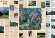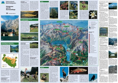
Königssee and its Surroundings - Nationalpark Berchtesgaden
Königssee and its Surroundings - Nationalpark Berchtesgaden
Königssee and its Surroundings - Nationalpark Berchtesgaden

You also want an ePaper? Increase the reach of your titles
YUMPU automatically turns print PDFs into web optimized ePapers that Google loves.
GB<br />
Lake <strong>Königssee</strong> in the heart of<br />
the <strong>Berchtesgaden</strong> National Park<br />
<strong>Königssee</strong> („king’s lake“) <strong>and</strong> <strong>its</strong><br />
surroundings lie in the activity zone<br />
of the <strong>Berchtesgaden</strong> National<br />
Park, founded in 1978. Boat traffic,<br />
fishing <strong>and</strong> cattle grazing are<br />
among the traditional uses of this<br />
zone. On the other h<strong>and</strong>, in the<br />
neighboring core zone of the park,<br />
the aim is to discourage any human<br />
use of the l<strong>and</strong> whatsoever.<br />
National Park<br />
Activity zone<br />
Core zone<br />
Here, nature’s development is allowed<br />
to take <strong>its</strong> course without interference.<br />
Here one accepts that<br />
forests grow old, decay <strong>and</strong> renew<br />
themselves once again in a natural<br />
way. It is a unique show of nature<br />
that we can no longer witness<br />
as spectators in our commercially<br />
used forests today.<br />
A Fjord-like lake in<br />
Central Europe<br />
The <strong>Königssee</strong> valley was created<br />
along a natural break in the rock.<br />
A river chiseled <strong>its</strong> way into it,<br />
<strong>Königssee</strong><br />
<strong>and</strong> <strong>its</strong><br />
<strong>Surroundings</strong><br />
Ramsau<br />
Free State of Bavaria<br />
Schönau<br />
am <strong>Königssee</strong><br />
<strong>Königssee</strong><br />
<strong>Berchtesgaden</strong><br />
forming a V shaped valley. It obtained<br />
<strong>its</strong> present shape during the<br />
ice ages: a mighty glacier of up to<br />
1000 m in height that stretched far<br />
into the alpine foothills chiseled out<br />
a U or trough shaped valley with a<br />
200 m deep basin. The melting glacier<br />
filled the bowl with water, resulting<br />
in the creation of a large lake.<br />
Another glacier, formed toward<br />
the end of the last ice age, caused<br />
the moraine that separates Obersee<br />
from <strong>Königssee</strong> today. The<br />
large boulders seen along the path<br />
between the two lakes, originate<br />
from a rock slide that occurred in<br />
1172.<br />
A lake with<br />
rare types of fish<br />
Lying in the heart of a largely undeveloped<br />
high mountain terrain,<br />
<strong>Königssee</strong> is one of Germany’s<br />
cleanest lakes. In order to ensure<br />
the good quality of the water, the<br />
sewage from the restaurants at St.<br />
Bartholomew <strong>and</strong> Salet, is piped<br />
under lake <strong>Königssee</strong> to the public<br />
sewage plant. Since 1909, the pas-<br />
The high mountain pastures<br />
around <strong>Königssee</strong><br />
In the immediate surroundings of<br />
<strong>Königssee</strong> <strong>and</strong> Obersee lie the<br />
cattle pastures („Alm“ in German)<br />
of Salet <strong>and</strong> Fischunkel, where<br />
cows graze during the summer<br />
months. Because the steep slope<br />
around the lake prevents any passage<br />
on foot, the cows are transported<br />
over the lake on barges<br />
to their summer pastures in the<br />
spring <strong>and</strong> then returned again<br />
in the autumn. It is interesting to<br />
note that both „mountain pastures“<br />
actually lie lower than the farms in<br />
which the cows winter.<br />
Centuries-old<br />
pasture rights<br />
A total of 25 cattle pastures are to<br />
be found within the activity zone of<br />
the National Park. The most extensive<br />
pasture area is found in the<br />
heights to the east of <strong>Königssee</strong><br />
between the Jenner mountain <strong>and</strong><br />
Obersee.<br />
Fallen-down huts, thickets of tall<br />
shrubs <strong>and</strong> sparse woodl<strong>and</strong>s<br />
in today’s protected core zone<br />
reveal that mountain farming <strong>and</strong><br />
forestry was once much more<br />
prevalent.<br />
The l<strong>and</strong> upon which the mountain<br />
pasture huts are built, is the property<br />
of the Free State of Bavaria.<br />
The farmer owns certain pasture<br />
rights that determine the pasture<br />
area, the type of animal <strong>and</strong> number<br />
allowed, as well as the grazing<br />
period. In some cases, the right is<br />
given to remove shrubs <strong>and</strong> young<br />
trees from the open meadows. Today,<br />
mostly young cows are led up<br />
to the pastures <strong>and</strong> only seldom is<br />
cheese <strong>and</strong> butter made up on the<br />
„Alm“. A special event that takes<br />
place every year in the autumn is<br />
the „Almabtrieb“ or transhumance<br />
senger boats of the „Bayerische<br />
Seenschifffahrt“ have been operated<br />
with electric motors. Due to the<br />
lack of nutrients, <strong>Königssee</strong>’s plant<br />
<strong>and</strong> animal life is limited, although<br />
rare types of fish, such as sea saibling<br />
<strong>and</strong> lake trout can be found<br />
here. Brook saibling, brook trout,<br />
perch <strong>and</strong> pike are also found in<br />
the lake. The green hue of the lake<br />
is due to small particles of limestone<br />
that break the sunlight.<br />
(the return of the cows to their winter<br />
quarters). If the summer up in<br />
the pastures has gone well, the<br />
cows are beautifully decorated<br />
before descending to the valley.<br />
The traditional headpiece called a<br />
„Fuikl“, is made from a pine wreath<br />
crown on which colorful dyed<br />
wood shavings are woven into<br />
rosettes.<br />
Woodl<strong>and</strong> grazing<br />
as a native use<br />
Every alpine pasture has a grazing<br />
area free of trees, as well as a<br />
wooded grazing zone. Because<br />
the cows nibble young trees <strong>and</strong><br />
cause damage with their hoofs, the<br />
National Park administration endeavors<br />
to resolve the problem of<br />
forest grazing rights on a voluntary<br />
basis.<br />
Plants<br />
Because of the difference in elevation<br />
of over 2000 m between the<br />
valley <strong>and</strong> the highest peaks, the<br />
<strong>Berchtesgaden</strong> National Park is exceptionally<br />
abundant in plant species.<br />
Of the numerous types of<br />
plant <strong>and</strong> animal life that coexist in<br />
correlation to one another, several<br />
are particularly easy to observe in<br />
the <strong>Königssee</strong> area.<br />
The sycamore is one of our most<br />
majestic trees. It is easy to recognize<br />
by <strong>its</strong> 5-pointed leaves <strong>and</strong> <strong>its</strong><br />
scaly bark, often covered with<br />
ferns, moss <strong>and</strong> lichens. The base<br />
of the branches can even collect<br />
humus where shrubs or even small<br />
trees can take root. Fine examples<br />
of this can be found on the beautiful<br />
old sycamore trees that grace<br />
the area around Obersee. These<br />
trees can live up to 600 years.<br />
Animals<br />
Marmots make their homes in the<br />
alpine meadows above the tree line.<br />
Thanks to the clearing of woodl<strong>and</strong><br />
areas for grazing, they could<br />
also inhabit lower regions. They<br />
True to <strong>its</strong> name the hirsute alpine<br />
rose with <strong>its</strong> hairy leaves <strong>and</strong> red<br />
flowers is native to woodl<strong>and</strong> clearings<br />
<strong>and</strong> open ground. In point of<br />
fact it is not a rose at all but belongs<br />
to the rhododendron plants.<br />
It is interesting to note that, though<br />
it is a typical high mountain plant,<br />
Funtenseetauern<br />
9<br />
8<br />
live in colonies or in family groups.<br />
Their food consists of grasses <strong>and</strong><br />
herbs. These animals use underground<br />
burrows as living, sleeping<br />
<strong>and</strong> hibernation quarters. During<br />
the winter months the marmots<br />
block off their dwellings <strong>and</strong> go into<br />
hibernation, living off their reserves<br />
of fat.<br />
One can best observe marmots at<br />
the mountain pastures – „Alms“ –<br />
of Königsbach, Königsberg <strong>and</strong><br />
Gotzen. One can hear their warning<br />
whistle from far away.<br />
Presumably not native to the<br />
region, ibex were introduced to the<br />
area of Röth, high above Obersee<br />
in 1937. Today one finds them around<br />
the Kahlersberg <strong>and</strong> Teufelshörner<br />
regions in the border zone<br />
between Bavaria <strong>and</strong> Austria.<br />
Schönfeldspitze<br />
Obersee<br />
13<br />
Gotzenalm<br />
12<br />
the alpine rose is sensitive to extreme<br />
cold. For this reason it is found<br />
only in areas protected in winter by<br />
a thick layer of snow. During the<br />
alpine rose’s blooming period in<br />
June <strong>and</strong> July, the south face of<br />
Mount Jenner looks like it is covered<br />
with red cushions.<br />
The „brown“ gentian with <strong>its</strong> blue,<br />
bell-shaped flower, is found from<br />
the National Park’s valleys all the<br />
way up to <strong>its</strong> alpine meadows.<br />
10<br />
1<br />
14<br />
13<br />
12 7<br />
P<br />
3<br />
Jenner<br />
Steinernes Meer<br />
Funtensee<br />
Boat traffic course<br />
3<br />
17<br />
2<br />
4<br />
15<br />
Jennerbahn<br />
16<br />
<strong>Königssee</strong><br />
Info<br />
5 6<br />
7 8<br />
2<br />
P<br />
9<br />
14<br />
10<br />
Kühroint<br />
1<br />
6<br />
15<br />
4<br />
Info<br />
Due to their limited living space<br />
<strong>and</strong> food supply, the number of<br />
ibex is maintained at around 60 to<br />
80, without needing to hunt them.<br />
For this reason they are not very<br />
shy around humans <strong>and</strong> can be<br />
observed from close up.<br />
This, however, required hours of<br />
hiking up into the higher climes of<br />
the National Park.<br />
Hundstod<br />
Watzmann<br />
11<br />
Grünstein<br />
Schönau a. <strong>Königssee</strong><br />
However, it is not the roots of this<br />
flower that are used to produce the<br />
gentian br<strong>and</strong>y but rather the<br />
tall-growing spotted gentian. The<br />
gentian distilling huts at Priesbergalm,<br />
at Röth or at Funtensee<br />
testify to this practice. The edelweiss<br />
comes originally from the Himalayas<br />
<strong>and</strong> has immigrated to the<br />
Alps over the past two million<br />
years. What makes this plant so<br />
attractive is <strong>its</strong> high, furry, white<br />
11<br />
16<br />
5<br />
P<br />
The sea saibling found in <strong>Königssee</strong><br />
feeds on tiny animals. When<br />
spawing, <strong>its</strong> belly <strong>and</strong> fins are<br />
colored bright red. Served smoked,<br />
saiblin is a fine delicacy.<br />
Our largest native raven species is<br />
the common raven <strong>and</strong> can often<br />
be viewed showing off <strong>its</strong> flight<br />
acrobatics in the higher regions<br />
of the National Park. Depending on<br />
leaves that form a star. The actual<br />
flower is formed by the small yellow<br />
parts in the center. Its white<br />
hair helps the plant reduce evaporation<br />
due to sun <strong>and</strong> wind, thus<br />
protecting <strong>its</strong>elf from drying out.<br />
Formerly the edelweiss was a common<br />
meadow flower above the<br />
alpine tree line. Man’s lack of respect<br />
for nature has led to <strong>its</strong> extinction<br />
in many places. It is now<br />
found only in crannies <strong>and</strong> unreachable<br />
rock faces.<br />
1 17<br />
Mountain huts<br />
<strong>and</strong> inns<br />
1<br />
2<br />
3<br />
4<br />
5<br />
6<br />
7<br />
8<br />
9<br />
10<br />
11<br />
12<br />
13<br />
14<br />
15<br />
16<br />
National border<br />
National park border<br />
Hiking paths <strong>and</strong><br />
mountain trails<br />
Cable-car<br />
National Park<br />
Information Point<br />
Highlights<br />
Gotzenalm<br />
Kärlingerhaus<br />
Riemannhaus<br />
Ingolstädter Haus<br />
Watzmannhaus<br />
Kührointhütte<br />
Dr.-Hugo-Beck-Haus<br />
Schneibsteinhaus<br />
Karl v. Stahlhaus<br />
Saletalm<br />
Grünsteinhütte<br />
Mitterkaseralm/Jenner<br />
Königsbachalm<br />
Jenner Berggaststätte<br />
St. Bartholomä<br />
Mitterkaseralm/Watzmann<br />
Publishing details:<br />
Bavarian State Ministry of Environmental Issues<br />
<strong>and</strong> Health – Published by: National Park Administration<br />
<strong>Berchtesgaden</strong>, Doktorberg 6, D-83471<br />
<strong>Berchtesgaden</strong>, Germany, Tel: +49(0)8652 /<br />
9686-0, Fax: +49(0)86 52 / 968640 – E-Mail:<br />
poststelle@npv-bgd.bayern.de – Internet: www.<br />
nationalpark-berchtesgaden.de – Text: J. Seidenschwarz,<br />
National Park Administration – English<br />
translation: David Harper, <strong>Berchtesgaden</strong> –<br />
Photos: W. Eisenkopf, A. Hafner <strong>and</strong> K. Wagner,<br />
National Park Administration – Panoramic map:<br />
W. Krabichler – Layout: N. Hasenknopf &<br />
GL-Werbestudio – Printed by Plenk, <strong>Berchtesgaden</strong><br />
– 6th edition 2011.<br />
Printed on environmentally friendly paper.<br />
the situation, <strong>its</strong> call varies from<br />
a deep „grog“ to „kark“ or „kroko“.<br />
It likes to use rock walls to build<br />
<strong>its</strong> nest. Another good flyer is <strong>its</strong><br />
smaller relative the alpine chough.<br />
One ca nobserve them up close<br />
on mountain peaks <strong>and</strong> around<br />
mountain huts. Its yellow beak is<br />
unmistakable.<br />
S I G H T S O F I N T E R E S T<br />
1 City of „Schönau am<br />
<strong>Königssee</strong>“<br />
Located directly at the lakeside of<br />
lake <strong>Königssee</strong>. From here the<br />
electrically driven boats start to the<br />
peninsula of St. Bartholomew.<br />
2 Malerwinkel<br />
Due to <strong>its</strong> beauty the <strong>Berchtesgaden</strong><br />
area was already popular<br />
with l<strong>and</strong>scape artists in the early<br />
19th century. Many of them favored<br />
Malerwinkel, the „painter’s corner“.<br />
3 Close to nature:<br />
mixed mountain forest<br />
Former forestry work strongly altered<br />
the lower forests in today’s<br />
National Park. The native mixed<br />
mountain forest of beech, sycamore,<br />
fir <strong>and</strong> spruce were replaced<br />
by spruce woods alone.<br />
In comparison, the forests on the<br />
steep slopes around <strong>Königssee</strong> are<br />
more natural. Wood was also cut<br />
here up until 1960 but the sheerness<br />
of the terrain hindered deforestation.<br />
Native trees were able to<br />
grow back on their own.<br />
4 Peninsula of St. Bartholomew<br />
The church <strong>and</strong> restaurant of St.<br />
Bartholomew are built on a delta<br />
jutting out into the lake. For the<br />
past 10,000 years it has built up<br />
through the weathering of Mount<br />
Watzmann’s cliffs.<br />
5 The Pilgrimage Church<br />
of St. Bartholomew<br />
The first „Basilica at Künigsee“ was<br />
consecrated in 1134. Romanesque<br />
in essence, it underwent renovation<br />
work in the Baroque style in<br />
1698 <strong>and</strong> 1710.<br />
The church is the destination of a<br />
traditional pilgrimage that starts in<br />
Maria Alm, Austria, <strong>and</strong> crosses<br />
„Steinernes Meer“.<br />
6 National Park Information<br />
Point at St. Bartholomew<br />
The information point is located in a<br />
historical forester’s hut. The exhibition’s<br />
theme focuses on nature’s<br />
constant change: processes that<br />
are paricularly easy to observe in<br />
the core zone of the National Park.<br />
In summer it is open daily.<br />
7 Wildlife feeding station<br />
To leave nature to <strong>its</strong>elf is the basic<br />
philosophy of a national park. This<br />
has <strong>its</strong> lim<strong>its</strong> however, due to the<br />
relatively small size of our National<br />
Park. The red deer’s natural wintering<br />
areas in the foothills have disappeared<br />
due to settling, road building,<br />
farming <strong>and</strong> forestry. It is thus<br />
replaced thanks to the feeding<br />
stations at St. Bartholomew <strong>and</strong> at<br />
Reitl on the opposite shore.<br />
8 Avalanches: natural dynamics<br />
A massive avalanche slipped down<br />
the Kleiner Watzmann in February<br />
1999, laying some 8 hectares of forest<br />
flat. A large number of the trees<br />
was not uprooted by the snow <strong>its</strong>elf<br />
but by the air pressure. In accordance<br />
with the National Park’s aims<br />
the h<strong>and</strong> of man did not intervene:<br />
the trees were left to lie. The forest<br />
will grow again without the help of<br />
man. The first young trees are already<br />
growing thanks to the already<br />
existing seedlings <strong>and</strong> to natural<br />
seed flight.<br />
9 Chapel of St. John<br />
<strong>and</strong> St. Paul<br />
The chapel was erected in high<br />
gothic style from 1617 to 1620, at a<br />
time when the baroque style had<br />
already taken over elsewhere. It is<br />
probably located at a former pagan<br />
shrine.<br />
10 The Ice Chapel<br />
The so-called ice chapel „Eiskapelle“<br />
is made of avalanche snow from<br />
the Watzmann’s east face through<br />
which the melting snow washes out<br />
a large opening in summer. Due to<br />
the fact that the ice <strong>and</strong> snow can<br />
collapse without warning at any<br />
time, climbing on or walking into<br />
the chapel is extremely dangerous.<br />
11 Mount Watzmann<br />
The <strong>Berchtesgaden</strong> National Park’s<br />
highest point is the Watzmann summit<br />
at 2713 m. Its eastern face with<br />
1800 m of sheer rock wall is the<br />
highest cliff in the Eastern Alps.<br />
Legend has it that a cruel king, his<br />
wife <strong>and</strong> seven children were<br />
turned to stone in the Watzmann<br />
Massif.<br />
12 Mount Jenner<br />
The Jenner, boasting a cable-car,<br />
offers magnificent views onto the<br />
National Park. Originally the Jenner<br />
was forested nearly up to <strong>its</strong> peak<br />
as scattered spruce near the summit<br />
still testify. The felling of trees<br />
<strong>and</strong> alpine grazing created today’s<br />
open l<strong>and</strong>scape covered with sparse<br />
grass, fields of dwarf pine <strong>and</strong> a<br />
scattering of thickets.<br />
13 Gotzenalm, Feuerpalfen<br />
High above <strong>Königssee</strong> lies Gotzenalm,<br />
first mentioned in the 8th century.<br />
This open pasture l<strong>and</strong> hosts arnica<br />
<strong>and</strong> spotted gentian flowers. Nearby,<br />
the sparse spruce growth is<br />
typical of woods that are used for<br />
grazing. The lookout point at nearby<br />
Feuerpalfen offers a magnificent<br />
view of <strong>Königssee</strong>.<br />
14 Kühroint, Archenkanzel<br />
Similar to Gotzenalm, the pasture<br />
huts at Kührointalm are perched on<br />
a plateau high above <strong>Königssee</strong>.<br />
South of this pasture, the Archenkanzel<br />
point offers a lovely view<br />
onto <strong>Königssee</strong>.<br />
15 National Park Information<br />
Point at Kühroint<br />
This information point is open daily<br />
during the season, depending on<br />
the business hours of the Kühroint<br />
hut.<br />
16 Funtensee<br />
Funtensee is located in a dolina, a<br />
funnel-shaped depression caused<br />
by the caving in of a grotto. Cattle<br />
was driven up to the Funtensee<br />
pasture up until 1962. The area is<br />
now included in the activity-free<br />
core zone of the National Park. The<br />
surrounding stone pine woods are<br />
somewhat of a botanical highlight.<br />
17 Steinernes Meer<br />
The Steinernes Meer (stony sea) is<br />
marked by barren <strong>and</strong> therefore<br />
impressive high alpine l<strong>and</strong>scapes.<br />
Its name comes from <strong>its</strong> wavelike<br />
surface made of rock that was deposited<br />
at the bottom of the sea<br />
some 200 million years ago, as<br />
shown by fossilized shells. Apart<br />
from caves <strong>and</strong> dolinas, one finds<br />
deep cuts in the rock, created<br />
by rain <strong>and</strong> melting snow over<br />
thous<strong>and</strong>s of years.
Flyer <strong>Königssee</strong>_e_04/2011 18.04.2011 14:49 Uhr Seite 2<br />
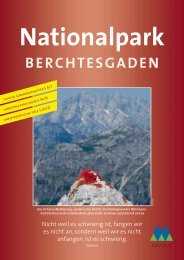
St. Bartholomew with Watzmann East Face. Photo K. Wagner, NPV