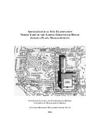
Excavations at Glaumbær - Fiske Center
Excavations at Glaumbær - Fiske Center
Excavations at Glaumbær - Fiske Center

You also want an ePaper? Increase the reach of your titles
YUMPU automatically turns print PDFs into web optimized ePapers that Google loves.
Appendix 4: Coordin<strong>at</strong>e System<br />
The same coordin<strong>at</strong>e system was used through the investig<strong>at</strong>ion <strong>at</strong> <strong>Glaumbær</strong> 2001-2005.<br />
Coordin<strong>at</strong>es are expressed in UTMs, zone 27, based on the Hjorsey 1955 d<strong>at</strong>um. With the<br />
availability of ISNET93 on GPS units SASS moved all survey work to the ISNET93<br />
system <strong>at</strong> the beginning of the 2005 season with the exception of the excav<strong>at</strong>ions <strong>at</strong><br />
<strong>Glaumbær</strong>. We felt th<strong>at</strong> is was better to preserve the grid used in previous test excav<strong>at</strong>ions<br />
and remote sensing in 2005 than to replace the coordin<strong>at</strong>e system.<br />
The original Hjorsey 1955 UTM grid was established using handheld differential GPS<br />
units (± 2 meters on the horizontal plane). This grid was checked <strong>at</strong> the beginning of the<br />
2005 excav<strong>at</strong>ion with the total st<strong>at</strong>ion and internally consistent to ± 0.10 meters over 50<br />
meters. All excav<strong>at</strong>ion coordin<strong>at</strong>es from <strong>Glaumbær</strong> are in the E 569000, N 7277000<br />
kilometer block. On forms and notes the full UTM coordin<strong>at</strong>es were usually abbrevi<strong>at</strong>ed<br />
to the last 4 digits (e.g., E 9035; N 7550). Vertical elev<strong>at</strong>ion coordin<strong>at</strong>es (z) based on a<br />
local d<strong>at</strong>um established <strong>at</strong> E 569000; N 727750.<br />
Two additional reference points were measured in based on the previous remote sensing<br />
grid and, after they were established, were used to set up the total st<strong>at</strong>ion each day (figure<br />
7).<br />
Figure 7. Remote sensing grid and additional reference points.<br />
22