Focus on Rock Engineering and Slope Stability - SRK Consulting
Focus on Rock Engineering and Slope Stability - SRK Consulting
Focus on Rock Engineering and Slope Stability - SRK Consulting

Create successful ePaper yourself
Turn your PDF publications into a flip-book with our unique Google optimized e-Paper software.
news<br />
<str<strong>on</strong>g>Focus</str<strong>on</strong>g> <strong>on</strong> <strong>Rock</strong> <strong>Engineering</strong> <strong>and</strong> <strong>Slope</strong> <strong>Stability</strong><br />
Internati<strong>on</strong>al slope stability research<br />
No. 43<br />
<strong>SRK</strong> C<strong>on</strong>sulting’s<br />
Internati<strong>on</strong>al<br />
Newsletter<br />
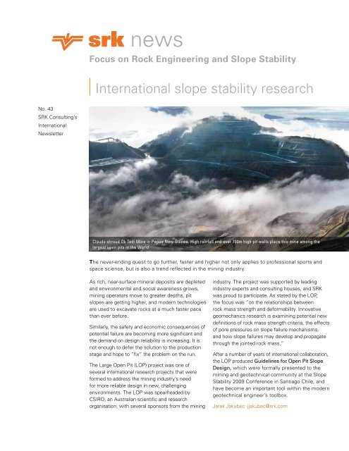
Clouds shroud Ok Tedi Mine in Papua New Guinea. High rainfall <strong>and</strong> over 700m high pit walls place this mine am<strong>on</strong>g the<br />
largest open pits in the World<br />
The never-ending quest to go further, faster <strong>and</strong> higher not <strong>on</strong>ly applies to professi<strong>on</strong>al sports <strong>and</strong><br />
space science, but is also a trend reflected in the mining industry.<br />
As rich, near-surface mineral deposits are depleted<br />
<strong>and</strong> envir<strong>on</strong>mental <strong>and</strong> social awareness grows,<br />
mining operators move to greater depths, pit<br />
slopes are getting higher, <strong>and</strong> modern technologies<br />
are used to excavate rocks at a much faster pace<br />
than ever before.<br />
Similarly, the safety <strong>and</strong> ec<strong>on</strong>omic c<strong>on</strong>sequences of<br />
potential failure are becoming more significant <strong>and</strong><br />
the dem<strong>and</strong> <strong>on</strong> design reliability is increasing. It is<br />
not enough to defer the soluti<strong>on</strong> to the producti<strong>on</strong><br />
stage <strong>and</strong> hope to “fix” the problem <strong>on</strong> the run.<br />
The Large Open Pit (LOP) project was <strong>on</strong>e of<br />
several internati<strong>on</strong>al research projects that were<br />
formed to address the mining industry’s need<br />
for more reliable design in new, challenging<br />
envir<strong>on</strong>ments. The LOP was spearheaded by<br />
CSIRO, an Australian scientific <strong>and</strong> research<br />
organisati<strong>on</strong>, with several sp<strong>on</strong>sors from the mining<br />
industry. The project was supported by leading<br />
industry experts <strong>and</strong> c<strong>on</strong>sulting houses, <strong>and</strong> <strong>SRK</strong><br />
was proud to participate. As stated by the LOP,<br />
the focus was “<strong>on</strong> the relati<strong>on</strong>ships between<br />
rock mass strength <strong>and</strong> deformability. Innovative<br />
geomechanics research is examining potential new<br />
definiti<strong>on</strong>s of rock mass strength criteria, the effects<br />
of pore pressures <strong>on</strong> slope failure mechanisms,<br />
<strong>and</strong> how slope failures may develop <strong>and</strong> propagate<br />
through the jointed rock mass.”<br />
After a number of years of internati<strong>on</strong>al collaborati<strong>on</strong>,<br />
the LOP produced Guidelines for Open Pit <strong>Slope</strong><br />
Design, which were formally presented to the<br />
mining <strong>and</strong> geotechnical community at the <strong>Slope</strong><br />
<strong>Stability</strong> 2009 C<strong>on</strong>ference in Santiago Chile, <strong>and</strong><br />
have become an important tool within the modern<br />
geotechnical engineer’s toolbox.<br />
Jarek Jakubec: jjakubec@srk.com<br />
1
Geotechnical characterisati<strong>on</strong><br />
The geological <strong>and</strong> geotechnical<br />
models are foundati<strong>on</strong>s of any mine<br />
design. These models could also be the<br />
leading sources of technical risks for<br />
mining projects. In order to minimise<br />
these risks, it is necessary to reduce<br />
the uncertainty in underst<strong>and</strong>ing the<br />
geological c<strong>on</strong>text of the deposit.<br />
With ever more sophisticated<br />
computer tools, it is possible to tackle<br />
more complex tasks in shorter times<br />
Jarek Jakubec<br />
Jarek Jakubec,<br />
C. Eng has over 25<br />
years of operating<br />
<strong>and</strong> c<strong>on</strong>sulting<br />
experience in<br />
mining, geology <strong>and</strong><br />
rock mechanics,<br />
including technical<br />
<strong>and</strong> managerial<br />
positi<strong>on</strong>s in operating mines in<br />
Canada, Botswana <strong>and</strong> the Czech<br />
Republic. As an <strong>SRK</strong> Engineer based<br />
in Vancouver, Jarek has worked <strong>on</strong> 70<br />
projects <strong>on</strong> all c<strong>on</strong>tinents, completing<br />
technical operati<strong>on</strong>al audits, <strong>and</strong><br />
due diligence studies, publishing<br />
technical papers <strong>and</strong> speaking at<br />
c<strong>on</strong>ferences. Jarek is also a Qualified<br />
Pers<strong>on</strong> for 43-101 reporting.<br />
Jarek Jakubec: jjakubec@srk.com<br />
MINING STUDIES, DESIGNS<br />
$<br />
DATA ANALYSIS,<br />
NUMERICAL MODELLING<br />
$<br />
FIELD CHARACTERISATION<br />
(CORE LOGGING, MAPPING)<br />
$<br />
than before. However, with advanced<br />
computerisati<strong>on</strong>, the mining industry<br />
also faces challenges c<strong>on</strong>cerning many<br />
designs that have been developed<br />
“in the office” without appropriate<br />
field data to support them <strong>and</strong> where<br />
the interpretati<strong>on</strong> of drilling <strong>and</strong><br />
mapping programs is poor. Today,<br />
project presentati<strong>on</strong>s are rich in eyecatching<br />
graphics, illustrating in 3D the<br />
geological models, stress distributi<strong>on</strong>,<br />
etc., <strong>and</strong> creating the impressi<strong>on</strong><br />
of reality <strong>and</strong> a full underst<strong>and</strong>ing<br />
of problems. Unfortunately, these<br />
impressi<strong>on</strong>s can often be misleading;<br />
the presented results may lack<br />
comm<strong>on</strong> geological <strong>and</strong> geotechnical<br />
sense, or are simply wr<strong>on</strong>g.<br />
The significance of using the<br />
appropriate geological <strong>and</strong> structural<br />
model is not always appreciated in<br />
characterising the geotechnical rock<br />
mass, which is often undertaken<br />
by engineers, not by geologists. On<br />
the other h<strong>and</strong>, geologists usually<br />
have a poor underst<strong>and</strong>ing of mine<br />
design processes, while engineers<br />
often disqualify the data collected at<br />
explorati<strong>on</strong> stages at more advanced<br />
stages of the project. It is important to<br />
make sure that all disciplines, geology,<br />
geotechnical <strong>and</strong> mining engineering,<br />
are fully integrated <strong>and</strong> that both<br />
underst<strong>and</strong> the mining method in order<br />
to produce reliable characterisati<strong>on</strong>s<br />
<strong>and</strong> increase c<strong>on</strong>fidence in the<br />
geotechnical analyses, numerical<br />
modelling <strong>and</strong>, finally, mine design.<br />
Jarek Jakubec: jjakubec@srk.com<br />
MINING STUDIES, DESIGNS<br />
DATA ANALYSIS,<br />
NUMERICAL MODELLING<br />
Geological <strong>and</strong> geotechnical field<br />
characterisati<strong>on</strong> are the foundati<strong>on</strong> of<br />
any mining study. If the characterisati<strong>on</strong><br />
<strong>and</strong> data are wr<strong>on</strong>g, the whole process of<br />
mine design could fail.<br />
Hazard identificati<strong>on</strong>: Best in class. Chuquicamata<br />
The word “risk” is widely used when<br />
people perceive a hazardous event,<br />
resulting in widely different percepti<strong>on</strong>s<br />
of risk. The technical definiti<strong>on</strong> of risk as<br />
used in geotechnical engineering is:<br />
Risk = P(event) x C<strong>on</strong>sequences.<br />
<strong>Slope</strong> design for large open-pit mines<br />
presents unique challenges to the<br />
engineer that are captured in the oftquoted<br />
maxim that “the objective is<br />
to have the slope fail the day after the<br />
last truckload of ore leaves the pit rim”.<br />
This infers that the maximum benefit<br />
has been extracted from the mineral<br />
resource. The engineer, however, has<br />
to provide a design that is functi<strong>on</strong>al<br />
<strong>and</strong> ec<strong>on</strong>omic at an acceptable risk.<br />
The great attracti<strong>on</strong> of the geotechnical<br />
discipline is that it relies <strong>on</strong> different<br />
engineering, geological <strong>and</strong> hydrogeological<br />
disciplines to achieve the<br />
stated objectives.<br />
Uncertainty <strong>and</strong> variability of properties<br />
within a rock mass provides the first<br />
challenge: How much data do we need<br />
2
Risk aware!!!<br />
Oskar Steffen<br />
to adequately describe the rock mass<br />
properties? Codes for data adequacy<br />
have been established for the minerals<br />
industry to define the geological<br />
certainty. <strong>SRK</strong> has used that same logic<br />
<strong>and</strong> applied it to geotechnical data, since<br />
this is also derived from the geological<br />
envir<strong>on</strong>ment. Early in the study program,<br />
geotechnical data requirements for<br />
different study levels can be defined<br />
using logic diagrams to determine<br />
the relative importance of different<br />
parameters. Effort <strong>and</strong> cost can then be<br />
focused <strong>on</strong> the more critical parameters,<br />
instead of the comm<strong>on</strong> “populate the<br />
database” procedures.<br />
This approach to geotechnical data<br />
collecti<strong>on</strong> has provided a rigorous<br />
process that allows explorati<strong>on</strong><br />
programs to be rati<strong>on</strong>alised <strong>and</strong> costjustified.<br />
While experienced judgment,<br />
embraced in the definiti<strong>on</strong> of the<br />
competent pers<strong>on</strong>, remains the anchor<br />
to success, the process suggested<br />
enhances such judgment decisi<strong>on</strong>s.<br />
Benchmarking data <strong>and</strong> processes<br />
against practical experience of slope<br />
performance is of paramount importance<br />
for defining the different levels of<br />
c<strong>on</strong>fidence, namely, levels that are<br />
measured, indicated <strong>and</strong> inferred.<br />
<strong>SRK</strong> has embarked up<strong>on</strong> a systematic<br />
recording of informati<strong>on</strong> quality at<br />
different sites <strong>on</strong>to data templates to<br />
improve the estimates of data required<br />
for different classes of geological<br />
complexity.<br />
These issues lie at the core of the<br />
engineer’s ethos to produce a design<br />
that can be termed functi<strong>on</strong>al <strong>and</strong><br />
ec<strong>on</strong>omic at an acceptable risk. For this<br />
reas<strong>on</strong>, risk valuati<strong>on</strong> in geotechnics<br />
must be upgraded to a quantified<br />
status as practiced in other engineering<br />
disciplines. <strong>SRK</strong> has adopted this<br />
c<strong>on</strong>cept of risk engineering, instead of<br />
risk assessment that follows after the<br />
engineering design.<br />
Oskar Steffen: osteffen@srk.co.za<br />
Dr Oskar Steffen, a<br />
corporate c<strong>on</strong>sultant<br />
with over 40 years’<br />
experience in the<br />
internati<strong>on</strong>al mining<br />
industry, is <strong>on</strong>e of the<br />
founders of the <strong>SRK</strong><br />
group. With a PhD<br />
in <strong>Engineering</strong> <strong>and</strong> a<br />
Master’s Degree in Civil <strong>Engineering</strong>, he<br />
places special emphasis <strong>on</strong> geotechnical<br />
<strong>and</strong> mine planning aspects of open pit<br />
mines. Oskar has been involved in open<br />
pit planning <strong>and</strong> design; rock <strong>and</strong> soil<br />
slope stability for road <strong>and</strong> rail cuttings<br />
<strong>and</strong> strip mines, <strong>and</strong> surface mining<br />
geotechnics, including slimes <strong>and</strong> tailings<br />
dam investigati<strong>on</strong> <strong>and</strong> design. He applies<br />
probability techniques in geotechnical<br />
engineering to slope failure analysis or<br />
strip stability investigati<strong>on</strong>s <strong>and</strong> slope<br />
design for coal strip mines <strong>and</strong> open pit<br />
mines internati<strong>on</strong>ally.<br />
Oskar Steffen: osteffen@srk.co.za<br />
3
3D modelling structurally c<strong>on</strong>trolled<br />
weak rock masses using blockiness<br />
jeff price<br />
Jeff has over<br />
20 years’ experience<br />
in civil <strong>and</strong><br />
mining geological<br />
engineering <strong>and</strong><br />
a PhD in fracture<br />
hydromechanics. His<br />
expertise includes<br />
investigati<strong>on</strong> <strong>and</strong><br />
design for open pit mines, tailings<br />
storage, <strong>and</strong> open pit <strong>and</strong> underground<br />
numerical modelling, especially for<br />
slope depressurisati<strong>on</strong> <strong>and</strong> open pitunderground<br />
interacti<strong>on</strong> for projects in<br />
Australasia, Russia <strong>and</strong> the former Soviet<br />
Uni<strong>on</strong>, South America <strong>and</strong> Africa. He is<br />
the Head of the <strong>SRK</strong> Perth Geotechnical<br />
Department, which includes teams<br />
covering mining geomechanics, tailings<br />
<strong>and</strong> heap leach engineering <strong>and</strong> mining<br />
hydrology <strong>and</strong> hydrogeology.<br />
Jeff Price: jprice@srk.com.au<br />
Velocity c<strong>on</strong>tour plot superimposed <strong>on</strong> oblique pit view looking north-northeast<br />
Design of deep open pits in structurally<br />
complex, weak deformable rock<br />
masses is a challenge. Recently, <strong>SRK</strong><br />
in c<strong>on</strong>juncti<strong>on</strong> with HTA C<strong>on</strong>sulting,<br />
engaged in assessing the slope stability<br />
for such a proposed pit. Experience<br />
has shown that incorporati<strong>on</strong> of the<br />
Geotechnical Blockiness Index (GBI)<br />
within the 3D geotechnical domain<br />
model improves our ability to simulate<br />
pit design performance.<br />
The digital geotechnical domain model,<br />
developed by project staff <strong>and</strong> HTA,<br />
c<strong>on</strong>sisted of four classificati<strong>on</strong>s:<br />
lithology, oxidati<strong>on</strong> state, alterati<strong>on</strong> <strong>and</strong><br />
GBI. The rock mass was divided into<br />
design sectors based <strong>on</strong> Mohr-Coulomb<br />
properties <strong>and</strong> ubquitous jointing,<br />
extensive laboratory testing <strong>and</strong> field<br />
investigati<strong>on</strong>. The figure at right shows<br />
variability in the distributi<strong>on</strong> of different<br />
material types.<br />
The numerical codes Slide, Phase 2<br />
<strong>and</strong> FLAC3D were used to assess<br />
potential instability. This staged<br />
approach raised c<strong>on</strong>fidence in the<br />
c<strong>on</strong>trolling instability mechanisms <strong>and</strong><br />
the interacti<strong>on</strong> of 3D c<strong>on</strong>finement <strong>on</strong><br />
slope performance. Applying strength<br />
reducti<strong>on</strong> factors (SRF) to the FLAC3D<br />
soluti<strong>on</strong> also dem<strong>on</strong>strated the<br />
potential development <strong>and</strong> extent of<br />
open pit instability. The figure above<br />
indicates z<strong>on</strong>es of velocities with cool<br />
colors referring to low, warm colors<br />
to moderate, <strong>and</strong> white color, high<br />
velocities.<br />
The FLAC3D runs incorporated<br />
rock mass <strong>and</strong> fabric variability to<br />
assess the sensitivity of the slope<br />
resp<strong>on</strong>se. Comparis<strong>on</strong> of the 2D <strong>and</strong><br />
3D models allowed a re-evaluati<strong>on</strong> of<br />
the expected rock mass performance<br />
so that the model results could be<br />
applied realistically to the slope design<br />
accounting for pit c<strong>on</strong>cavity.<br />
C<strong>on</strong>clusi<strong>on</strong>s from the study indicated:<br />
• The applicati<strong>on</strong> of the GBI improved<br />
the quality of the geotechnical data<br />
set <strong>and</strong> enabled better definiti<strong>on</strong> of<br />
areas of poor rock mass quality<br />
• The use of 3D modelling to assess<br />
the critical design criteria, using<br />
4
Estimating rock mass strength<br />
Estimating rock mass strength<br />
(RMS) remains <strong>on</strong>e of the challenges<br />
facing rock mechanics practiti<strong>on</strong>ers.<br />
The infinite variability of geology,<br />
weathering <strong>and</strong> alterati<strong>on</strong> processes,<br />
the influence of mining <strong>and</strong> the inability<br />
to test rock mass strength directly,<br />
all pose great challenges to making<br />
reliable estimates. The experience<br />
of the practiti<strong>on</strong>er, therefore, plays a<br />
crucial role in such estimates.<br />
Although the problem with estimating<br />
RMS is not yet solved, in recent years<br />
another approach was developed<br />
that helps to provide more realistic<br />
estimates <strong>and</strong> generate <strong>and</strong> evaluate<br />
“what if” scenarios. This approach is<br />
called synthetic rock mass (SRM) <strong>and</strong><br />
was pi<strong>on</strong>eered by Itasca C<strong>on</strong>sulting.<br />
It involves calibrating small-scale<br />
specimen strength, developing<br />
digitized detailed models of fracture<br />
<strong>and</strong> other defects called discrete<br />
fracture network (DFN) <strong>and</strong> estimating<br />
defect strength.<br />
In close collaborati<strong>on</strong> with Itasca, <strong>SRK</strong><br />
used this approach <strong>on</strong> several worldclass<br />
projects as input for further<br />
analysis, such as investigating block<br />
cave fragmentati<strong>on</strong>. This approach is<br />
crucial, especially in rock masses that<br />
c<strong>on</strong>tain numerous defects such as<br />
microfractures, veinlets <strong>and</strong> cemented<br />
joints. It is encouraging to see that the<br />
results of SRM models are compatible<br />
with the empirical method of estimating<br />
rock block <strong>and</strong> rock mass strength<br />
developed by Dr Dennis Laubscher,<br />
author of <strong>on</strong>e of the widely used<br />
rock mass classificati<strong>on</strong>s systems, in<br />
collaborati<strong>on</strong> with <strong>SRK</strong> in 2000.<br />
Practical experience gained from<br />
SRM analysis <strong>on</strong> mining operati<strong>on</strong>s<br />
<strong>and</strong> projects gives <strong>SRK</strong> a significant<br />
advantage in assessing rock mass<br />
strength more realistically than in the<br />
past using traditi<strong>on</strong>al industry tools.<br />
Jarek Jakubec: jjakubec@srk.com<br />
detailed geotechnical <strong>and</strong> structural<br />
domain model, provided a sound<br />
basis for a reassessment of the<br />
slope design<br />
• 3D <strong>and</strong> 2D analyses were used<br />
to simulate slope performance<br />
<strong>and</strong> provide guidance <strong>on</strong> pit slope<br />
design. 3D analysis show an<br />
increase in SRF, compared to the 2D<br />
analyses (typically 20 to 30% higher)<br />
• FLAC3D results were used to<br />
review the existing 2D slope design<br />
parameters resulting in steeper<br />
than recommended slope geometry<br />
Jeff Price: jprice@srk.com.au<br />
Intact <strong>Rock</strong><br />
(B<strong>on</strong>ded spheres in<br />
Particle Flow Code)<br />
Joints<br />
+ =<br />
(DFN)<br />
<strong>Rock</strong><br />
Mass<br />
Synthetic rock mass applicati<strong>on</strong> for a jointed copper porphyry deposit<br />
FLAC3D model cross-secti<strong>on</strong> showing<br />
cohesi<strong>on</strong> in kPa, looking west<br />
5
Itabirite ir<strong>on</strong> ore bodies:<br />
Generic geotechnical models<br />
<strong>SRK</strong> has recently been involved at<br />
the feasibility <strong>and</strong> pre-feasibility level<br />
studies <strong>on</strong> a number of large-scale ir<strong>on</strong><br />
ore projects in west <strong>and</strong> central Africa<br />
<strong>and</strong> Brazil. Experience across these<br />
locati<strong>on</strong>s has highlighted a number of<br />
similarities that should be c<strong>on</strong>sidered<br />
when generating a geotechnical model<br />
in itabirites.<br />
In the weathered horiz<strong>on</strong>, itabirites<br />
are characterised by str<strong>on</strong>g ir<strong>on</strong> b<strong>and</strong>s<br />
<strong>and</strong> weaker silica b<strong>and</strong>s resulting in a<br />
significant degree of anisotropy, where<br />
Alice Jack<br />
Alice Jack is<br />
a Geotechnical<br />
Engineer with six<br />
years’ experience<br />
in explorati<strong>on</strong> <strong>and</strong><br />
mining geotechnics<br />
in Europe, Asia <strong>and</strong><br />
Africa, including<br />
civil engineering<br />
geotechnics <strong>and</strong> foundati<strong>on</strong> design<br />
experience both abroad <strong>and</strong> in the glacial<br />
<strong>and</strong> coal measure rocks of South Wales.<br />
Her expertise includes limit equilibrium <strong>and</strong><br />
the analysis <strong>and</strong> design of finite element<br />
slope stability, seismic, structural <strong>and</strong><br />
kinematic analysis, underground rock<br />
mechanics, assessing <strong>and</strong> c<strong>on</strong>ceptualizing<br />
rock <strong>and</strong> soil masses, geological <strong>and</strong><br />
geotechnical mapping, borehole core<br />
logging <strong>and</strong> geotechnical data collecti<strong>on</strong><br />
<strong>and</strong> interpretati<strong>on</strong>, training of site<br />
pers<strong>on</strong>nel, site <strong>and</strong> project management.<br />
Alice Jack: ajack@srk.co.uk<br />
materials react differently to stresses<br />
applied in the directi<strong>on</strong> of b<strong>and</strong>ing. It is<br />
therefore important to determine if this<br />
b<strong>and</strong>ing is c<strong>on</strong>sistent in terms of directi<strong>on</strong>,<br />
which can often be seen to run parallel<br />
to the footwall c<strong>on</strong>tact if this c<strong>on</strong>tact is<br />
c<strong>on</strong>formable or of a similar nature. By<br />
c<strong>on</strong>trast, material that is unweathered or<br />
str<strong>on</strong>gly foliated can be very str<strong>on</strong>g <strong>and</strong><br />
produce massive block sizes, intersected<br />
by unfavourable disc<strong>on</strong>tinuity sets.<br />
The process of ore formati<strong>on</strong> <strong>and</strong> depth<br />
of leaching can have a significant impact<br />
<strong>on</strong> the state of the silica b<strong>and</strong>ing within<br />
the itabirites <strong>and</strong> their subsequent<br />
geotechnical behaviour, as well as the<br />
behaviour of the surrounding waste<br />
rocks. The itabirites can form a boundary<br />
protecting the surrounding waste rock<br />
from the processes involved in the<br />
ore formati<strong>on</strong>. For example, in itabirite<br />
deposits in Guinea, there is a str<strong>on</strong>g<br />
correlati<strong>on</strong> between the friability of<br />
the itabirite <strong>and</strong> the degradati<strong>on</strong> of the<br />
surrounding phyllitic waste rocks.<br />
Due to the massive size of these<br />
itaboritic ore bodies, <strong>and</strong> the drilling<br />
problems associated with them<br />
particularly in tropical regi<strong>on</strong>s, it is often<br />
difficult to gain the desired degree of<br />
structural informati<strong>on</strong>. Phyllitic <strong>and</strong><br />
ampholitic marker horiz<strong>on</strong>s within the<br />
itabirites can be seen <strong>on</strong> geophysical<br />
gamma-gamma logs <strong>and</strong> can be<br />
correlated between boreholes which<br />
can prove useful in interpreting largescale<br />
macro structure <strong>and</strong> determining<br />
lithological offsets, particularly where<br />
there is little surface exposure.<br />
Alice Jack: ajack@srk.co.uk<br />
Rapid development techniques<br />
maximise activity at the tunnel face<br />
<strong>and</strong> advance completi<strong>on</strong> rates without<br />
compromising safety. Good project<br />
planning should prepare for both<br />
expected ground c<strong>on</strong>diti<strong>on</strong>s <strong>and</strong><br />
unexpected variati<strong>on</strong>s in the rock mass<br />
to be excavated. This will reduce delays<br />
<strong>and</strong> mitigate the effect of poor ground<br />
c<strong>on</strong>diti<strong>on</strong>s, which can slow advance<br />
rates by 50%.<br />
It is no surprise that poor ground<br />
slows advance rates. For example, the<br />
industry-leading development practices<br />
at Newcrest’s Cadia East operati<strong>on</strong> in<br />
New South Wales produced better than<br />
average advance rates in the access<br />
decline. Rapid development rates of<br />
over 8 m/day were achieved using<br />
l<strong>on</strong>ger drilling rounds <strong>and</strong> emulsi<strong>on</strong><br />
explosives, but the project still suffered<br />
low advance rates of less than 3 m/day<br />
as a c<strong>on</strong>sequence of poor ground.<br />
Investment in a “rapid development”<br />
program is usually justified to realise<br />
higher Net Present Value for a project.<br />
The risk of not being able to excavate<br />
the rock mass as planned can result in<br />
inadequate predicti<strong>on</strong> <strong>and</strong> preparati<strong>on</strong><br />
to deal with the actual ground types<br />
encountered.<br />
A Ground C<strong>on</strong>trol Management Plan<br />
(GCMP) created from site investigati<strong>on</strong><br />
data can mitigate this risk. An active<br />
GCMP uses data collected prior to <strong>and</strong><br />
during excavati<strong>on</strong>. The aim is to predict<br />
ground c<strong>on</strong>diti<strong>on</strong>s <strong>and</strong> select design<br />
c<strong>on</strong>trol methods through a structured<br />
risk management approach.<br />
C<strong>on</strong>fidence in predictive models<br />
increases with geological, structural<br />
<strong>and</strong> geotechnical mapping, <strong>and</strong> ground<br />
behaviour m<strong>on</strong>itoring. Feedback is<br />
essential to keep the GCMP “live”.<br />
Itabirite outcrop in the Caitite deposit Brazil<br />
6
Safe <strong>and</strong> rapid development for major<br />
underground mines: Trends for the future<br />
Mine development plan<br />
z<strong>on</strong>ed by ground support<br />
classificati<strong>on</strong><br />
Kobus du Plooy<br />
Kobus du Plooy,<br />
BSc, GDE, Pr.Sci.<br />
Nat, MIEAust is a<br />
Senior Geotechnical<br />
Engineer with 16<br />
years’ experience<br />
in the mining<br />
industry, combined<br />
with geotechnical<br />
c<strong>on</strong>sulting experience. Kobus started<br />
his career in the rock engineering<br />
department of AngloGold-Ashanti, where<br />
he gained valuable experience in the<br />
areas of shallow to deep level hard-rock<br />
mining. He started his c<strong>on</strong>sulting career<br />
with <strong>SRK</strong> C<strong>on</strong>sulting (South Africa) in 2000<br />
<strong>and</strong> also worked for Brentley, Lucas <strong>and</strong><br />
Associates before joining <strong>SRK</strong> C<strong>on</strong>sulting<br />
(Australasia) in 2007. In recent years,<br />
Kobus has been involved in projects in<br />
Australia, Ind<strong>on</strong>esia, Kazakhstan, Siberia<br />
<strong>and</strong> South Africa.<br />
Kobus du Plooy: kduplooy@srk.com.au<br />
Tim McGurk<br />
The Modified <strong>Rock</strong> Mass<br />
Rating (MRMR) system is<br />
<strong>on</strong>e of the tools than can<br />
help to identify z<strong>on</strong>es, based<br />
<strong>on</strong> similar ground behaviour.<br />
”Rapid development” ground<br />
c<strong>on</strong>trol can include techniques<br />
such as phased installati<strong>on</strong> of<br />
ground support <strong>and</strong> drilling short<br />
rounds. Comm<strong>on</strong> practice, such as<br />
pattern rock bolting, meshing <strong>and</strong><br />
shotcreting, could be complemented<br />
with practices such as setting arches<br />
<strong>and</strong> stabilisati<strong>on</strong> grouting.<br />
In c<strong>on</strong>clusi<strong>on</strong>, it was proven that<br />
active Ground C<strong>on</strong>trol Management<br />
Planning has an essential role in all<br />
rapid development projects.<br />
Kobus du Plooy: kduplooy@srk.com.au<br />
Tim McGurk: tmcgurk@srk.co.uk<br />
Tim McGurk is<br />
Principal Mining<br />
Engineer with 20<br />
years’ experience in<br />
underground mine<br />
design, producti<strong>on</strong>,<br />
c<strong>on</strong>structi<strong>on</strong> <strong>and</strong><br />
management.<br />
His operati<strong>on</strong>al<br />
experience includes stope <strong>and</strong> fill,<br />
sub-level caving <strong>and</strong> room <strong>and</strong> pillar in<br />
zinc, gold, nickel <strong>and</strong> silica operati<strong>on</strong>s.<br />
He was resp<strong>on</strong>sible for mine producti<strong>on</strong><br />
<strong>and</strong> development, including decline<br />
access to around 800 vertical metres at<br />
Black Swan Nickel Mine. For Rio Tinto<br />
<strong>and</strong> <strong>SRK</strong> since 2008, he reviewed <strong>and</strong><br />
managed scoping <strong>and</strong> pre-feasibility<br />
studies for diam<strong>on</strong>d, copper, gold <strong>and</strong><br />
industrial minerals.<br />
Tim McGurk: tmcgurk@srk.co.uk<br />
7
Bruce Murphy<br />
Bruce Murphy is a<br />
Principal C<strong>on</strong>sultant<br />
in <strong>SRK</strong>’s Vancouver<br />
office with over 20<br />
years’ experience<br />
in operati<strong>on</strong>al<br />
<strong>and</strong> c<strong>on</strong>sulting<br />
envir<strong>on</strong>ments,<br />
both in open-pit<br />
<strong>and</strong> underground<br />
rock engineering. He specialises in<br />
establishing the geotechnical <strong>and</strong> mining<br />
c<strong>on</strong>text of existing <strong>and</strong> potential deposits<br />
by integrating structural geology, rock<br />
mass characterisati<strong>on</strong> <strong>and</strong> c<strong>on</strong>sidering<br />
hydrogeology, permafrost <strong>and</strong> existing<br />
excavati<strong>on</strong> performance. Bruce has<br />
worked <strong>on</strong> many projects in Canada,<br />
the US, South America, Africa, Russia,<br />
Kyrgyzstan <strong>and</strong> Ind<strong>on</strong>esia.<br />
Bruce Murphy: bmurphy@srk.com<br />
Introducing<br />
Scott Carlisle<br />
Mining challenges in permafrost<br />
envir<strong>on</strong>ments<br />
Portal locati<strong>on</strong> for the underground explorati<strong>on</strong> decline<br />
The Kumtor gold project is located<br />
in the mountainous terrain of the<br />
Tien Shan Mountains in the Kyrgyz<br />
Republic, at an altitude of around<br />
4000m. The mean annual temperature<br />
is minus 8°C.<br />
For many reas<strong>on</strong>s, starting the decline<br />
near the glacier, within the c<strong>on</strong>stricted ore<br />
z<strong>on</strong>e was c<strong>on</strong>sidered the most favorable<br />
opti<strong>on</strong>, in particular, since it would reach<br />
the more competent ground of the<br />
hangingwall units more quickly.<br />
Scott Carlisle, M.S.,<br />
P. Eng., is a Principal<br />
C<strong>on</strong>sultant in rock<br />
mechanics <strong>and</strong><br />
mining. He has 18<br />
years’ experience in<br />
underground mining<br />
operati<strong>on</strong>s <strong>and</strong> civil<br />
c<strong>on</strong>structi<strong>on</strong> <strong>and</strong> 12<br />
years in c<strong>on</strong>sulting. As a rock mechanics<br />
practiti<strong>on</strong>er, he has a wide range of<br />
experience, including risk assessment,<br />
strategic planning, high stress mining,<br />
mine method selecti<strong>on</strong> <strong>and</strong> design,<br />
stope design <strong>and</strong> sequencing, crown<br />
pillars, rock failure investigati<strong>on</strong>s, rock<br />
support, instrumentati<strong>on</strong> <strong>and</strong> modelling.<br />
Scott participates in mining <strong>and</strong> rock<br />
mechanics research activities in Canada.<br />
Scott Carlisle: scarlisle@srk.com<br />
Locating <strong>and</strong> designing an explorati<strong>on</strong><br />
decline to access <strong>and</strong> explore the<br />
mineralised horiz<strong>on</strong> below the operating<br />
open pit proved to be a challenging<br />
experience as a result of poor ground<br />
c<strong>on</strong>diti<strong>on</strong>s, widespread glaciati<strong>on</strong> <strong>and</strong><br />
locati<strong>on</strong> of the waste dumps. Once<br />
the locati<strong>on</strong> of decline was chosen,<br />
the team faced several engineering<br />
design challenges including weather,<br />
permafrost <strong>and</strong> a drop-cut within a<br />
glacial moraine with ice lenses.<br />
The mine geology c<strong>on</strong>sists of four<br />
major thrust slices. The slice hosting<br />
the mineralisati<strong>on</strong> is composed of<br />
phyllites that are str<strong>on</strong>gly folded<br />
<strong>and</strong> schistose. The footwall c<strong>on</strong>tact<br />
of this structural segment is the<br />
well-developed <strong>and</strong> weak Kumtor<br />
Fault Z<strong>on</strong>e. The adjacent rocks in its<br />
hangingwall are str<strong>on</strong>gly affected<br />
by shearing <strong>and</strong> faulting for several<br />
hundred meters.<br />
An Armtec Multi-Plate® tunnel support<br />
was to be installed within the drop-cut<br />
<strong>and</strong> covered with engineered fill to<br />
protect the decline access from slope<br />
instability, snow falls <strong>and</strong> possible<br />
avalanches. Ice lenses within the moraine<br />
could affect the stability of the slopes<br />
<strong>and</strong> the Armtec tunnel foundati<strong>on</strong>, where<br />
heated air would be drawn underground.<br />
To keep the Armtec foundati<strong>on</strong> frozen,<br />
thermosyph<strong>on</strong>s were installed to cool the<br />
ground when the ambient air is colder<br />
than the subsurface.<br />
The <strong>SRK</strong> team developed site-specific<br />
rock classes based <strong>on</strong> the GSI <strong>and</strong> NGI<br />
Tunnelling Quality Index (Q) classificati<strong>on</strong><br />
systems. The rock mass c<strong>on</strong>diti<strong>on</strong>s<br />
range from Fair to a Very Poor rating in<br />
graphitic phyllite near fault structures.<br />
A site specific system was selected<br />
to better characterise <strong>and</strong> differentiate<br />
the weaker rock masses. Following<br />
a full geotechnical evaluati<strong>on</strong>, four<br />
8
Shea Creek uranium project<br />
support classes were developed ranging<br />
from c<strong>on</strong>venti<strong>on</strong>al bolt, screen <strong>and</strong><br />
shotcrete, to spilling <strong>and</strong> steel arch (full<br />
invert) support. Using the Rocscience<br />
software Phase 2 a squeezing ground<br />
assessment was undertaken, with steel<br />
set <strong>and</strong> shotcrete support simulated as a<br />
composite liner.<br />
Since the support materials <strong>and</strong><br />
installati<strong>on</strong> processes needed to functi<strong>on</strong><br />
within the initial cold permafrost ground<br />
temperatures, choices included an<br />
oil-based rebar resin, <strong>and</strong> a customised<br />
shotcrete mixture that used heated<br />
aggregate <strong>and</strong> high water temperatures.<br />
With a moving glacier <strong>and</strong> waste dump<br />
material <strong>on</strong> the surface, it was extremely<br />
difficult to produce a full geotechnical<br />
evaluati<strong>on</strong> al<strong>on</strong>g the proposed<br />
path of the decline. To manage the<br />
geotechnical risk, the team developed<br />
a comprehensive process of cover<br />
<strong>and</strong> probe drilling <strong>and</strong> m<strong>on</strong>itoring of<br />
excavati<strong>on</strong> <strong>and</strong> support performance.<br />
<strong>SRK</strong>, as part of a multi-disciplinary team<br />
helped develop this complex design.<br />
The Shea Creek Project, owned jointly<br />
by AREVA Resources Canada Inc. <strong>and</strong><br />
UEX Corporati<strong>on</strong>, with AREVA acting<br />
as project operator, is an advanced<br />
uranium project located approximately<br />
700km NNW of Saskato<strong>on</strong> <strong>and</strong><br />
approximately 30km east of the Alberta<br />
border, within the western Athabasca<br />
Basin of northern Saskatchewan. The<br />
property is underlain by two dominant<br />
lithologies: metamorphic basement<br />
rocks of Archean <strong>and</strong> Paleoproterozoic<br />
granitoid, covered by Proterozoic<br />
flat-lying to shallow-dipping, postmetamorphic<br />
quartz s<strong>and</strong>st<strong>on</strong>e.<br />
Uranium mineralisati<strong>on</strong> is of the<br />
unc<strong>on</strong>formity-associated uranium<br />
deposit type. It occurs 710 to 740<br />
meters below the current surface<br />
<strong>and</strong> beneath the thick sequence<br />
of Athabasca Group s<strong>and</strong>st<strong>on</strong>e.<br />
Three styles of mineralisati<strong>on</strong> are<br />
encountered, based <strong>on</strong> their positi<strong>on</strong><br />
adjacent to the Athabasca unc<strong>on</strong>formity,<br />
<strong>and</strong> overall morphology. They comprise<br />
unc<strong>on</strong>formity-hosted, basement-hosted,<br />
<strong>and</strong> perched uranium mineralisati<strong>on</strong>.<br />
Uranium mineralisati<strong>on</strong> is associated<br />
with extensive clay alterati<strong>on</strong>, which<br />
affects the lower s<strong>and</strong>st<strong>on</strong>e <strong>and</strong><br />
extends into the basement rocks.<br />
<strong>SRK</strong> evaluated <strong>and</strong> refined an existing<br />
structural site model to define the<br />
potential risks to a c<strong>on</strong>ceptual stage<br />
underground mine design. <strong>SRK</strong> then<br />
incorporated the analysis of drillcore<br />
data <strong>and</strong> photos, 3D geological<br />
modelling, whole-rock geochemistry,<br />
<strong>and</strong> geophysics to evaluate the potential<br />
structures, which are blind at surface.<br />
During the studies four generati<strong>on</strong>s<br />
of faults were identified, each with<br />
individual fill, roughness, strength, <strong>and</strong><br />
permeability characteristics, including<br />
previously unidentified faults that may<br />
affect uranium distributi<strong>on</strong>.<br />
James Siddorn: jsiddorn@srk.com<br />
James Siddorn<br />
James Siddorn,<br />
PhD, PGeo,<br />
is a Principal<br />
Structural<br />
Geologist with<br />
<strong>SRK</strong>’s Tor<strong>on</strong>to<br />
office. He is a<br />
specialist in<br />
the structural<br />
analysis of ore<br />
deposits, focused <strong>on</strong> deciphering<br />
the deposit scale c<strong>on</strong>trols <strong>on</strong> ore<br />
plunge, geotechnical domains, <strong>and</strong><br />
hydrogeological pathways. James has<br />
extensive underground <strong>and</strong> surface<br />
mapping experience <strong>and</strong> broad mining<br />
experience in c<strong>on</strong>venti<strong>on</strong>al <strong>and</strong><br />
mechanised underground mining. He<br />
has spent 15 years in the structural<br />
analysis <strong>and</strong> 3D geological modelling<br />
of Au, Ni-Cu-PGE, Ag, U 3 O 8 , tantalum,<br />
<strong>and</strong> diam<strong>on</strong>d deposits.<br />
James Siddorn: jsiddorn@srk.com<br />
Bruce Murphy: bmurphy@srk.com<br />
3D fault network with the Athabasca s<strong>and</strong>st<strong>on</strong>e unc<strong>on</strong>formity, Shea Creek<br />
9
Integrating structural geology <strong>and</strong><br />
geotechnics, Los Caracoles Dam<br />
The Los Caracoles is a 140m high<br />
hydropower water dam, located in San<br />
Juan Province, Argentina, in an arid<br />
regi<strong>on</strong> of high seismic activity. The<br />
spillway system c<strong>on</strong>sists of two large<br />
parallel tunnels while the gateway<br />
structure is formed by two twin boxes,<br />
each 30m high, excavated in the<br />
upstream slope of the abutment.<br />
Natural stability relies in the c<strong>on</strong>tinuity<br />
of the rock layers al<strong>on</strong>g the entire<br />
slope <strong>and</strong> into the foundati<strong>on</strong> levels<br />
but this c<strong>on</strong>tinuity would be altered<br />
by the gateway excavati<strong>on</strong>. Design<br />
countermeasures were necessary to<br />
keep the slope stable.<br />
So<strong>on</strong> after the excavati<strong>on</strong> started,<br />
fractures appeared <strong>on</strong> the shotcreted<br />
slope surface, the excavati<strong>on</strong> face, <strong>and</strong><br />
the rock buttress. The job was halted<br />
<strong>and</strong> <strong>SRK</strong> was called in. The photo below<br />
shows the excavati<strong>on</strong> <strong>and</strong> buttress<br />
status at that time.<br />
<strong>SRK</strong> performed a thorough site<br />
inspecti<strong>on</strong> <strong>and</strong> detailed analysis of<br />
all c<strong>on</strong>ceivable failure modes <strong>and</strong><br />
determined that, due to the shape<br />
of the buttress <strong>and</strong> lack of lateral<br />
c<strong>on</strong>finement, the sec<strong>on</strong>dary joints or<br />
fractures had been activated so the rock<br />
mass slipped al<strong>on</strong>g them. The outcome<br />
was that sec<strong>on</strong>dary joints, other than<br />
the bedding planes, had been activated<br />
due to the shape of the buttress <strong>and</strong><br />
lack of lateral c<strong>on</strong>finement. A sec<strong>on</strong>d<br />
reinforcing bolt system (passive,<br />
grouted rockbolts made with rebars)<br />
perpendicular to the original <strong>on</strong>e, was<br />
designed <strong>and</strong> installed inmediately,<br />
<strong>and</strong> the excavati<strong>on</strong> was c<strong>on</strong>tinued <strong>and</strong><br />
completed successfully.<br />
Another challenge was the design of<br />
the gateway. The gateway is a critical<br />
comp<strong>on</strong>ent of the spillway, <strong>and</strong> must<br />
remain operative after an earthquake.<br />
It was feared that the slope would<br />
displace further during an earthquake,<br />
deform the c<strong>on</strong>crete structure <strong>and</strong><br />
block the gateway.<br />
When dynamic slope stability analyses<br />
were performed to address this<br />
c<strong>on</strong>cern, <strong>SRK</strong> found that two large<br />
blocks were potentially unstable. For<br />
the first block, a step-by-step dynamic<br />
Newmark analysis showed that the<br />
support system would need to carry<br />
650 MN to assure that its displacement<br />
during the shake was compatible with<br />
operating the gates. Two large c<strong>on</strong>crete<br />
buttresses were built near the rock<br />
buttress, both c<strong>on</strong>fining it laterally <strong>and</strong><br />
carrying part of the huge load.<br />
Unfortunately, the 250 MN sec<strong>on</strong>d<br />
block does not c<strong>on</strong>tact either the<br />
rock or the c<strong>on</strong>crete buttress. Twenty<br />
prestressed permanent anchors were<br />
designed <strong>and</strong> installed to reduce<br />
displacement. After this design change,<br />
the project was completed <strong>and</strong> works<br />
successfully.<br />
Alejo Sfriso: asfriso@srk.com.ar<br />
St<strong>and</strong>ing <strong>on</strong> footwall of open pit coal mine, Colombia<br />
For pit slope design, geotechnical<br />
data is typically collected by mapping<br />
the benches to supplement data<br />
collected from boreholes. Where an<br />
open pit has been in operati<strong>on</strong> for<br />
some years, bench faces are often<br />
difficult to access <strong>and</strong>, increasingly,<br />
access is being restricted to reduce<br />
the risk of exposure to rockfall<br />
hazards. In order to address these<br />
issues, photogrammetry is being used<br />
more frequently.<br />
<strong>SRK</strong> C<strong>on</strong>sulting (UK) Ltd has<br />
acquired the expertise to undertake<br />
photogrammetric surveys using the<br />
Sirovisi<strong>on</strong>® system developed by<br />
CSIRO Australia. Besides purchasing<br />
the data manipulati<strong>on</strong> <strong>and</strong> analysis<br />
software, <strong>SRK</strong> has invested in the<br />
photographic <strong>and</strong> survey equipment<br />
needed to collect the data.<br />
<strong>SRK</strong> has previously used Sirovisi<strong>on</strong>®<br />
successfully <strong>on</strong> a number of open-pit<br />
projects. In Colombia, South America,<br />
Upstream face of Los Caracoles <strong>and</strong> excavati<strong>on</strong> for the spillway tunnels<br />
10
X<strong>and</strong>er Gwynn<br />
Use of photogrammetric mapping<br />
techniques for slope stability<br />
X<strong>and</strong>er Gwynn<br />
holds a BSc (H<strong>on</strong>s) in<br />
<strong>Engineering</strong> Geology<br />
<strong>and</strong> Geotechnics<br />
(ACSM) <strong>and</strong> has<br />
been studying for<br />
a PhD in Earth<br />
Resources at the<br />
Camborne School<br />
of Mines, University<br />
of Exeter. He joined <strong>SRK</strong> in April 2008<br />
<strong>and</strong> is currently finishing his PhD thesis.<br />
X<strong>and</strong>er previously worked offshore<br />
in the oil industry after completing his<br />
undergraduate degree. He specialises<br />
in the geotechnical characterisati<strong>on</strong> of<br />
rock masses using photogrammetric<br />
mapping methods. X<strong>and</strong>er’s PhD focuses<br />
<strong>on</strong> the assessment <strong>and</strong> advancement of<br />
digital remote data capture techniques<br />
for natural <strong>and</strong> man-made slopes. He is<br />
now applying his PhD expertise for <strong>SRK</strong><br />
<strong>and</strong> is able to undertake Sirovisi<strong>on</strong>®<br />
photogrammetric mapping for various<br />
open-pit, end-use applicati<strong>on</strong>s.<br />
X<strong>and</strong>er Gwynn: xgwynn@srk.co.uk<br />
<strong>SRK</strong>’s brief was to carry out a slope<br />
design optimisati<strong>on</strong> study for a cut<br />
back of an open-pit coal mine that<br />
would increase the height of the<br />
highwall from 150m to 250m. As part<br />
of this study, during a five-day site<br />
visit, Sirovisi<strong>on</strong> ® was used to:<br />
• Map large-scale geological<br />
structures <strong>on</strong> the existing highwall.<br />
For this the camera set up was<br />
positi<strong>on</strong>ed at the footwall slope<br />
crest about 400m from the highwall<br />
• Capture bench scale structural<br />
data for use in detailed kinematic<br />
analysis from close range (4m-10m)<br />
In c<strong>on</strong>juncti<strong>on</strong> with the large-scale<br />
mapping, detailed physical properties<br />
of over 1200 individual disc<strong>on</strong>tinuity<br />
occurrences were obtained from<br />
selected bench face locati<strong>on</strong>s. These<br />
properties included:<br />
• Three dimensi<strong>on</strong>al locati<strong>on</strong> of<br />
features<br />
• Orientati<strong>on</strong> (dip/dip directi<strong>on</strong>)<br />
• Trace lengths/plane area (also used<br />
to calculate joint persistence)<br />
• Large-scale joint surface roughness<br />
• Terminati<strong>on</strong> indexes (to ascertain<br />
feature chr<strong>on</strong>ology)<br />
• Fracture set spacing<br />
Sirovisi<strong>on</strong> ® allowed the rapid collecti<strong>on</strong><br />
of a large data set of new structural<br />
informati<strong>on</strong>, saving the client time <strong>and</strong><br />
m<strong>on</strong>ey over more traditi<strong>on</strong>al methods<br />
of geotechnical data collecti<strong>on</strong>. The<br />
structural data collected, together with<br />
the incorporati<strong>on</strong> of newly measured<br />
faults into the geotechnical model,<br />
provided for robust <strong>and</strong> statisticallysound<br />
kinematic analysis of the<br />
proposed new highwall pit slope<br />
design. The 3D positi<strong>on</strong>al informati<strong>on</strong><br />
of the coal seams <strong>and</strong> other geological<br />
boundaries allowed the geological<br />
model to be verified <strong>and</strong> updated.<br />
X<strong>and</strong>er Gwynn: xgwynn@srk.co.uk<br />
Alejo Sfriso<br />
Alejo, Principal<br />
Geotechnical<br />
Engineer, is<br />
managing director<br />
for <strong>SRK</strong> (Argentina).<br />
C<strong>on</strong>currently, he<br />
serves as Professor<br />
of Soil Mechanics<br />
<strong>and</strong> Head of the<br />
Geomechanics Group<br />
at the University of Buenos Aires. His<br />
academic <strong>and</strong> professi<strong>on</strong>al experience<br />
is reflected in the many papers he has<br />
authored <strong>and</strong> delivered at c<strong>on</strong>ferences<br />
worldwide. For <strong>SRK</strong>, Alejo <strong>and</strong> his<br />
team focus <strong>on</strong> optimising c<strong>on</strong>structi<strong>on</strong><br />
processes, providing expert c<strong>on</strong>sultancy<br />
in geotechnical engineering, tunnel<br />
design, soil-structure interacti<strong>on</strong> <strong>and</strong><br />
computati<strong>on</strong>al geomechanics.<br />
Alejo Sfriso: asfriso@srk.com.ar<br />
11
Assessing geotechnical management<br />
using the Ground Blockiness Index (GBI)<br />
DAMANG FAULT<br />
Locati<strong>on</strong> plan of the Damang pit layout in April 2009<br />
Risk management <strong>and</strong> risk assessment<br />
are important processes, <strong>and</strong> should<br />
be applied to both the development of<br />
mining studies <strong>and</strong> the implementati<strong>on</strong><br />
of designs. <strong>SRK</strong> has completed a risk<br />
assessment as part of the cutback<br />
feasibility study <strong>and</strong> practical design for<br />
the Damang pit in Ghana.<br />
For operati<strong>on</strong>al risk management,<br />
reliable field data needs to be<br />
collected. By using the Geotechnical<br />
Blockiness Index (GBI) in our field<br />
mapping, <strong>SRK</strong> applied a rapid<br />
rock mass characterisati<strong>on</strong> tool to<br />
accelerate assessment at Damang.<br />
The GBI c<strong>on</strong>cept, developed by Diane<br />
Walker <strong>and</strong> Ian de Bruyn of <strong>SRK</strong><br />
(Perth) in 2006 classifies the rock<br />
mass according to 8 categories of<br />
block size <strong>and</strong> rock mass texture. It<br />
has the additi<strong>on</strong>al benefit that direct<br />
access to the face is not required.<br />
<strong>Rock</strong> mass domains were derived<br />
from field observati<strong>on</strong>s, which were<br />
related to locati<strong>on</strong>s shown in the<br />
adjacent site plan. The locati<strong>on</strong> plan<br />
(left) shows the shows the principal<br />
East <strong>and</strong> West Wall domains as Good,<br />
Fair <strong>and</strong> Poor in green, yellow <strong>and</strong> red,<br />
respectively. The rock mass c<strong>on</strong>diti<strong>on</strong>s<br />
were extrapolated where similar<br />
c<strong>on</strong>diti<strong>on</strong>s were assessed as likely<br />
to be encountered. The approximate<br />
water level is shown by the light blue<br />
colored infill.<br />
The Good rock z<strong>on</strong>e comprises<br />
s<strong>and</strong>st<strong>on</strong>e <strong>and</strong>, locally, dolerite, where<br />
it has been intruded al<strong>on</strong>g bedding<br />
structures. The domain fabric typically<br />
comprises large blocky to massive, very<br />
thin, widely-spaced bedding shears with<br />
occasi<strong>on</strong>al minor wedge or planar failure.<br />
The Fair rock mass z<strong>on</strong>e exposes the<br />
steeply dipping Damang Fault. The<br />
rock mass quality generally appears<br />
similar to the Good domain, although<br />
the presence of the fault provides<br />
a z<strong>on</strong>e of persistent sub-vertical<br />
structural weakness.<br />
The Poor domain corresp<strong>on</strong>ds to the<br />
z<strong>on</strong>e where bedding shears <strong>and</strong> faults<br />
intersect with reduced block size,<br />
variable bedding dip <strong>and</strong> the flatter<br />
westerly dipping joints <strong>and</strong> shears.<br />
12
UDEC modelling<br />
View of Damang cutback looking south<br />
The risk assessment incorporated the<br />
results of the GBI mapping with the<br />
Abosso Goldfields risk-assessment<br />
methodology. Geotechnical hazards<br />
were c<strong>on</strong>sidered in terms of the<br />
c<strong>on</strong>sequences of slope failure. The<br />
principal hazards for the Damang Pit<br />
relate to the perceived instability of<br />
slope elements at decreasing scale<br />
(from the whole slope to an individual<br />
bench), including whether there<br />
was a ramp at risk, <strong>and</strong> according to<br />
slope material (oxide, weathered or<br />
unweathered rock).<br />
The Damang cutback is generally<br />
situated within str<strong>on</strong>g rock.<br />
Blockiness variability within the<br />
main pit walls represents an<br />
important structural c<strong>on</strong>trol <strong>on</strong> bench<br />
performance. The approach adopted<br />
presents a robust field technique<br />
that allowed identificati<strong>on</strong> of<br />
comm<strong>on</strong> geotechnical domains, <strong>and</strong><br />
categorisati<strong>on</strong> <strong>and</strong> definiti<strong>on</strong> of risk<br />
mitigati<strong>on</strong> measures.<br />
Jeff Price: jprice@srk.com.au<br />
The Universal Distinct Element Code<br />
(UDEC), developed by the ITASCA<br />
C<strong>on</strong>sulting Group, is a “distinctive<br />
element program for disc<strong>on</strong>tinuum<br />
modelling”. UDEC simulates the<br />
resp<strong>on</strong>se of disc<strong>on</strong>tinuous media<br />
(different rock types) when they are<br />
subjected to either static or dynamic<br />
loading. Linear or n<strong>on</strong>-linear forcedisplacement<br />
causes movement in<br />
both normal <strong>and</strong> shear directi<strong>on</strong>s.<br />
<strong>SRK</strong> used UDEC modelling <strong>on</strong><br />
part of the east pit of a gold mine<br />
in western China to gain a better<br />
underst<strong>and</strong>ing of the mechanical<br />
behavior of the rocks in the two main<br />
joint sets encountered in the east<br />
wall, when the upper pit is excavated<br />
sequentially, <strong>and</strong> to provide a basis for<br />
the design of the final pit.<br />
Two cases were modelled:<br />
• Model 1: Includes <strong>on</strong>ly <strong>on</strong>e set, 1m<br />
c<strong>on</strong>tinuous<br />
• Model 2: Includes both sets, 1m<br />
c<strong>on</strong>tinuous <strong>and</strong> 4m disc<strong>on</strong>tinuous<br />
It was assumed that the horiz<strong>on</strong>tal<br />
<strong>and</strong> vertical stresses are equal<br />
<strong>and</strong> are caused purely by their<br />
own weight. A strength reducti<strong>on</strong><br />
technique was used to evaluate the<br />
factor of safety (FOS). The material<br />
Figure 1: Factor of safety (FOS = 2.05)<br />
UDEC (Versi<strong>on</strong> 4.00)<br />
LEGEND<br />
22-Aug-06 8:18<br />
cycle 207101<br />
time = 1.247E+02 sec<br />
table plot<br />
3.30E-01 stab 301>5.05E+00 _____<br />
Vs.<br />
1.00E+002.20E+00<br />
<strong>SRK</strong> C<strong>on</strong>sulting China Ltd<br />
Beijing China<br />
strength was reduced to a level<br />
where the pit becomes unstable <strong>and</strong><br />
failure develops. Figure 1 shows<br />
the point where the slope becomes<br />
unstable, providing clues to the likely<br />
mechanical behavior of the pit walls<br />
as the pit is gradually deepened.<br />
Y<strong>on</strong>glian Sun: ysun@srk.cn<br />
Y<strong>on</strong>glian Sun<br />
Dr Y<strong>on</strong>glian Sun<br />
is a Principal<br />
C<strong>on</strong>sultant with over<br />
20 years’ experience<br />
in geotechnical<br />
engineering, rock<br />
mechanics <strong>and</strong><br />
mining engineering.<br />
He has worked in<br />
five countries across four c<strong>on</strong>tinents. His<br />
c<strong>on</strong>siderable experience emphasizes<br />
site investigati<strong>on</strong>, analysis <strong>and</strong> modelling<br />
of geotechnical issues in open pits,<br />
underground mines <strong>and</strong> tunnels, <strong>and</strong><br />
evaluating mining projects. Y<strong>on</strong>glian<br />
established the <strong>SRK</strong> (China) Beijing office<br />
in 2005 <strong>and</strong> 49 full-time employees now<br />
provide technical review, explorati<strong>on</strong><br />
management <strong>and</strong> audits, design, scoping<br />
<strong>and</strong> feasibility studies <strong>on</strong> mining projects.<br />
Y<strong>on</strong>glian Sun: ysun@srk.cn<br />
5.50<br />
5.00<br />
4.50<br />
4.00<br />
3.50<br />
3.00<br />
2.50<br />
2.00<br />
1.50<br />
1.00<br />
0.50<br />
0.00<br />
0.80 1.00 1.20 1.40 1.60 1.80 2.00 2.20 2.40<br />
13
Antamina geological modelling, Peru<br />
The Antamina Cu-Zn mine which<br />
lies in the high Andes of Peru,<br />
270km north of Lima, is operated by<br />
Compañía Minera Antamina S.A., for a<br />
c<strong>on</strong>sortium of owners including BHP<br />
Billit<strong>on</strong>, Xstrata, Teck Resources, <strong>and</strong><br />
Mitsubishi Ltd. An expansi<strong>on</strong> of the<br />
mine has been recently approved which<br />
takes advantage of a 75% increase in<br />
reserves; the current extracti<strong>on</strong> rate of<br />
94,000 t<strong>on</strong>nes/day will be increased<br />
Sally Goodman<br />
Sally Goodman,<br />
PhD, PGeo, is a<br />
Principal C<strong>on</strong>sultant<br />
with <strong>SRK</strong>’s Tor<strong>on</strong>to<br />
office. She has<br />
over 20 years’<br />
experience in the<br />
structural analysis<br />
of complex areas.<br />
Her key skill is<br />
integrating the structural framework<br />
with diverse data sets to rec<strong>on</strong>struct<br />
the spatial <strong>and</strong> temporal development of<br />
mineralising systems. She applies this<br />
skill to ranking project targets, optimising<br />
drill-testing, resource estimati<strong>on</strong>, grade<br />
c<strong>on</strong>trol <strong>and</strong> geotechnical studies in<br />
Europe, North <strong>and</strong> South America.<br />
Sally has taught geology at McGill <strong>and</strong><br />
C<strong>on</strong>cordia Universities, M<strong>on</strong>treal.<br />
Sally Goodman: sgoodman@srk.com<br />
by 38% by 2012, with a corresp<strong>on</strong>ding<br />
extensi<strong>on</strong> of the mine life to 2029.<br />
With a rapidly exp<strong>and</strong>ing open pit in<br />
mountainous terrain, it is imperative<br />
to have a good underst<strong>and</strong>ing of the<br />
structural <strong>and</strong> lithological architecture,<br />
to ensure c<strong>on</strong>tinuing safe <strong>and</strong> profitable<br />
extracti<strong>on</strong> of the orebody.<br />
Since 2004, <strong>SRK</strong> has been involved in<br />
producing <strong>and</strong> updating a 3D model<br />
of the major structures in the vicinity<br />
of the open pit. The current model<br />
comprises 60 structures in 6 suites of<br />
faults, characterised by their initiati<strong>on</strong><br />
<strong>and</strong> development history, c<strong>on</strong>tinuity<br />
<strong>and</strong> geotechnical characteristics. A 3D<br />
Leapfrog TM geological model produced<br />
from drillhole data shows the distributi<strong>on</strong><br />
of the major rock types encountered<br />
during pit development, including<br />
intrusive rocks, endoskarn <strong>and</strong> exoskarn,<br />
hornfels, marble <strong>and</strong> limest<strong>on</strong>e, as<br />
illustrated <strong>and</strong> explained below.<br />
The combined structural <strong>and</strong><br />
lithological models have been used<br />
for a variety of purposes, including<br />
geological <strong>and</strong> geotechnical evaluati<strong>on</strong>s<br />
<strong>and</strong> hydrogeological studies. As<br />
development of the mine proceeds,<br />
updated informati<strong>on</strong> will c<strong>on</strong>tinually be<br />
used to revise <strong>and</strong> refine the structural<br />
geological model.<br />
Sally Goodman: sgoodman@srk.com<br />
Leapfrog TM model of<br />
distributi<strong>on</strong> of intrusive<br />
rocks (pink), endoskarn<br />
(brown), exoskarn (green),<br />
hornfels (light blue), marble<br />
<strong>and</strong> limest<strong>on</strong>e (dark blue),<br />
domained to a future pit shell,<br />
to show distributi<strong>on</strong> of rock<br />
type in pit walls<br />
Left: Wedge failure resulting in closure of the pit<br />
Right: Pit <strong>and</strong> general surface arrangement<br />
The Koidu Kimberlite Project is<br />
situated in the K<strong>on</strong>o District of Sierra<br />
Le<strong>on</strong>e, approximately 330 km east of<br />
the capital city, Freetown. The mining<br />
lease area is 4km 2 <strong>and</strong> comprises<br />
two kimberlite pipes, four dyke z<strong>on</strong>es<br />
<strong>and</strong> a number of blows off the dykes.<br />
In 2003, Koidu Holdings established<br />
operati<strong>on</strong>s <strong>on</strong> the property <strong>and</strong><br />
began dewatering <strong>and</strong> removing silt<br />
from the existing 30m excavati<strong>on</strong><br />
of the No.1 Pipe. While the original<br />
planning for the pipes included<br />
c<strong>on</strong>venti<strong>on</strong>al open pit operati<strong>on</strong>s,<br />
mitigating factors such as the<br />
proximity of the town, the presence<br />
of houses close to the perimeter<br />
of the pit, the size of the kimberlite<br />
pipe <strong>and</strong> the planned open pit depth,<br />
combined with relevant stripping<br />
ratios <strong>and</strong> uncertainties <strong>on</strong> the<br />
grades c<strong>on</strong>cerning an underground<br />
operati<strong>on</strong>, lent themselves to the<br />
vertical pit c<strong>on</strong>cept. A diagram<br />
showing the comparis<strong>on</strong> of a<br />
c<strong>on</strong>venti<strong>on</strong>al pit <strong>and</strong> vertical pit is<br />
included as Figure 1.<br />
14
Koidu vertical pit, Sierra Le<strong>on</strong>e<br />
Peter Terbrugge<br />
Peter Terbrugge, a<br />
Principal <strong>Engineering</strong><br />
Geologist, has over<br />
40 years’ experience<br />
in engineering<br />
geology, rock<br />
slope stability,<br />
site investigati<strong>on</strong>s<br />
<strong>and</strong> tunnelling. His<br />
expertise includes open pit slope design<br />
for large copper mines, diam<strong>on</strong>d mines,<br />
gold mines <strong>and</strong> ir<strong>on</strong> ore mines; feasibility<br />
studies; the design of remedial measures<br />
to maintain access in critical areas, civil<br />
engineering projects.<br />
Peter Terbrugge: pterbrugge@srk.co.za<br />
Elevati<strong>on</strong><br />
391m<br />
Surface<br />
Elevati<strong>on</strong><br />
391m<br />
Surface<br />
350m<br />
345m<br />
335m<br />
Old pit floor<br />
Blast 1<br />
335m Cut<br />
350m<br />
339m<br />
Vertical Pit<br />
collar<br />
310m<br />
310m Cut<br />
310m<br />
Vertical Pit<br />
270m<br />
270m Cut<br />
Cut Ore T<strong>on</strong>nes Waste T<strong>on</strong>nes Strip Ratio<br />
335m Cut 79,400 488,000 6.2<br />
310m Cut 158,000 1,000,000 6.3<br />
270m Cut 317,000 4,300,000 13.6<br />
265m<br />
Cut Ore T<strong>on</strong>nes Waste T<strong>on</strong>nes Strip Ratio<br />
339m Cut 54,200 485,000 9.6<br />
Collar Devel. 845,600<br />
Vertical Pit 551,000 358,000 0.65<br />
Figure 1: Comparis<strong>on</strong> of the open pit <strong>and</strong> vertical pit scenarios<br />
The vertical pit was established<br />
using an A-frame headgear for the<br />
hoisting arrangement, with sidewall<br />
support comprising a combinati<strong>on</strong><br />
of cable anchors 20m <strong>and</strong> 40m<br />
l<strong>on</strong>g, rock bolts, wire mesh <strong>and</strong><br />
pneumatically applied c<strong>on</strong>crete. The<br />
pit reached steady state producti<strong>on</strong><br />
in January 2007 <strong>and</strong> produced some<br />
26,000 t<strong>on</strong>nes of head feed per<br />
m<strong>on</strong>th until August 2007, when<br />
mining reached a depth of 74m<br />
below the pit collar (approximately<br />
126m below surface). Mining was<br />
suspended following a sidewall<br />
failure that disrupted operati<strong>on</strong>s.<br />
Now that the grades in No.1 Pipe<br />
have been validated, the focus<br />
has switched to an underground<br />
operati<strong>on</strong> taking account of both<br />
No. 1 Pipe <strong>and</strong> No. 2 Pipe.<br />
While the mining costs for the<br />
vertical pit have been higher than for<br />
a c<strong>on</strong>venti<strong>on</strong>al open pit, the c<strong>on</strong>cept<br />
did circumvent the social implicati<strong>on</strong>s,<br />
the issue of grade c<strong>on</strong>sistency <strong>and</strong><br />
diam<strong>on</strong>d value at depth; it also<br />
provided the time to carry out a full<br />
underground mining study.<br />
Peter Terbrugge: pterbrugge@srk.co.za<br />
15
Ian de Bruyn<br />
Ian de Bruyn has<br />
15 years experience<br />
in the geotechnical<br />
engineering field,<br />
over a wide range<br />
of projects in both<br />
the mining <strong>and</strong> civil<br />
engineering sectors.<br />
He has str<strong>on</strong>g<br />
expertise in geotechnical assessment<br />
<strong>and</strong> in providing design parameters<br />
for open pit mining operati<strong>on</strong>s. He<br />
has worked <strong>on</strong> projects involving very<br />
large pits in challenging rock mass<br />
c<strong>on</strong>diti<strong>on</strong>s. He is well versed in rock mass<br />
characterisati<strong>on</strong> <strong>and</strong> domain modelling<br />
for input into fragmentati<strong>on</strong> analysis, the<br />
selecti<strong>on</strong> of mining method <strong>and</strong> support<br />
design for underground mines. Ian’s<br />
projects have involved site investigati<strong>on</strong>,<br />
characterisati<strong>on</strong>, analysis, evaluati<strong>on</strong>,<br />
design, risk assessment <strong>and</strong> reporting at<br />
all levels – from c<strong>on</strong>ceptual through prefeasibility,<br />
feasibility <strong>and</strong> working design.<br />
Ian de Bruyn: idbruyn@srk.com.au<br />
Jim cremeens<br />
Jim Cremeens<br />
has over 20 years’<br />
experience in<br />
geotechnical<br />
engineering,<br />
primarily related to<br />
the mining industry.<br />
He has managed<br />
large multidisciplinary<br />
projects,<br />
both domestically <strong>and</strong> internati<strong>on</strong>ally. His<br />
areas of expertise include surface rock<br />
mechanics, heap leach facility design,<br />
<strong>and</strong> mine reclamati<strong>on</strong>. Jim is a registered<br />
professi<strong>on</strong>al engineer in Colorado<br />
<strong>and</strong> New York, <strong>and</strong> is a registered<br />
professi<strong>on</strong>al geologist in Wyoming.<br />
Numerical analyses for evaluating pit wall<br />
<strong>and</strong> underground stability at Ok Tedi<br />
The southeast pit wall at Ok Tedi<br />
A staged numerical analysis program<br />
was c<strong>on</strong>ducted for the final pit<br />
<strong>and</strong> proposed underground mining<br />
excavati<strong>on</strong>s at Ok Tedi Mine in<br />
Papua, New Guinea. The analyses<br />
were c<strong>on</strong>ducted to evaluate the<br />
performance of the final east <strong>and</strong><br />
west pit walls, <strong>and</strong> the stability of<br />
the underground mining excavati<strong>on</strong>s<br />
beneath these walls, as mining<br />
progresses. These evaluati<strong>on</strong>s were<br />
intended to facilitate the design<br />
<strong>and</strong> to assist with decisi<strong>on</strong>-making<br />
c<strong>on</strong>cerning the viability of the<br />
underground mining project.<br />
The mine is situated in a complex<br />
geological setting including faulted <strong>and</strong><br />
highly altered rock in an area that is<br />
seismically active <strong>and</strong> that is subject to<br />
very high rainfall. Detailed geotechnical<br />
characterisati<strong>on</strong> <strong>and</strong> hydrogeological<br />
modelling was therefore carried out<br />
to provide accurate input for the<br />
numerical analyses.<br />
The numerical analyses were<br />
performed while the most suitable<br />
mining methods were still being<br />
assessed, <strong>and</strong> therefore the analysis<br />
had to be flexible in method <strong>and</strong><br />
applicati<strong>on</strong>. The initial method selected<br />
was two-dimensi<strong>on</strong>al distinct element<br />
analysis using UDEC software for<br />
evaluating pit wall stability throughout<br />
the underground mining sequences.<br />
However, it became evident that<br />
certain mining geometries were not<br />
amenable to satisfactory analysis<br />
in two dimensi<strong>on</strong>s. Therefore, <strong>SRK</strong><br />
performed three-dimensi<strong>on</strong>al finite<br />
difference analyses using FLAC3D<br />
to investigate pit wall <strong>and</strong> rock mass<br />
stability <strong>and</strong> the effectiveness of<br />
prospective stabilisati<strong>on</strong> measures.<br />
In additi<strong>on</strong>, <strong>SRK</strong> performed boundary<br />
element modelling to rapidly assess<br />
the likely extent <strong>and</strong> magnitude of<br />
stress c<strong>on</strong>centrati<strong>on</strong>s within the rock<br />
mass.<br />
Jim Cremeens: jcremeens@srk.com<br />
16
Blasting program optimises pit slope<br />
performance<br />
An Open Benching mining method<br />
was originally c<strong>on</strong>sidered, with the<br />
remainder of the ore then to be mined<br />
out by these underground methods:<br />
Sub Level Caving beneath the east<br />
<strong>and</strong> southwest pit walls, <strong>and</strong> Block<br />
Caving beneath the central west<br />
pit wall. Subsequent to the first<br />
phase of numerical analyses, it was<br />
decided that <strong>on</strong>ly underground mining<br />
methods would be used.<br />
C<strong>on</strong>clusi<strong>on</strong>s were reached c<strong>on</strong>cerning<br />
the risk <strong>and</strong> scale of slope failure<br />
resulting from the underground / pit<br />
wall stress interacti<strong>on</strong>s. <strong>SRK</strong> assessed<br />
measures to mitigate the failure of<br />
slopes <strong>and</strong> underground excavati<strong>on</strong>s,<br />
including using rock-fill to minimise<br />
underground voids, <strong>and</strong> leaving<br />
stabilising pillars within the orebody.<br />
Ian de Bruyn: idebruyn@srk.com.au<br />
Bart<strong>on</strong> Mines, a garnet mining operati<strong>on</strong><br />
in upstate New York, c<strong>on</strong>tracted <strong>SRK</strong><br />
to c<strong>on</strong>duct a slope stability evaluati<strong>on</strong><br />
of the active Ruby Mountain pit. Three<br />
geotechnical coreholes were planned,<br />
al<strong>on</strong>g with cell mapping of the pit<br />
exposures to provide data for the<br />
slope stability analyses. During our site<br />
investigati<strong>on</strong>, it became apparent that<br />
rock mass characteristics would not limit<br />
the slope design. The rock was relatively<br />
uniform lithology, <strong>and</strong> of relatively high<br />
strength. <strong>SRK</strong> recommended against<br />
drilling the third geotechnical corehole,<br />
because the uniformity of the rock mass<br />
observed in the first two coreholes<br />
indicated that collecting more data<br />
would not significantly affect design<br />
recommendati<strong>on</strong>s.<br />
<strong>SRK</strong> also observed that the slope<br />
instability in the Ruby Mountain pit was<br />
due primarily to failure of the blocks of<br />
rock created by a more or less r<strong>and</strong>omlyoriented<br />
fracture system, characteristic<br />
of blast induced damage. The instability<br />
was not necessarily c<strong>on</strong>sistent with<br />
the tect<strong>on</strong>ic rock structures observed.<br />
Based <strong>on</strong> these observati<strong>on</strong>s <strong>and</strong><br />
given the high rock strength <strong>and</strong><br />
favorable orientati<strong>on</strong> of structures, <strong>SRK</strong><br />
recommended that a full-scale pit slope<br />
evaluati<strong>on</strong> was not warranted. Instead,<br />
a review of the blasting design was<br />
c<strong>on</strong>sidered.<br />
<strong>SRK</strong> made several recommendati<strong>on</strong>s<br />
regarding blast procedures. These<br />
included decreasing the producti<strong>on</strong> hole<br />
burden, using bottom-up det<strong>on</strong>ati<strong>on</strong><br />
<strong>on</strong> the pre-split row, <strong>and</strong> changing to<br />
zero subgrade <strong>on</strong> the pre-split row.<br />
As a result of implementing these<br />
recommendati<strong>on</strong>s, there was very little<br />
blast damage to the pit walls, allowing<br />
a near vertical pit face to develop in<br />
the high strength rock. Oversized rock<br />
had previously created the need for<br />
sec<strong>on</strong>dary blasting <strong>and</strong> h<strong>and</strong>ling. The<br />
<strong>SRK</strong> blast recommendati<strong>on</strong>s significantly<br />
reduced the amount of oversized rock<br />
<strong>and</strong> the associated cost of sec<strong>on</strong>dary<br />
h<strong>and</strong>ling <strong>and</strong> blasting.<br />
The reducti<strong>on</strong> in the drilling program,<br />
<strong>and</strong> the resoluti<strong>on</strong> of pit stability issues<br />
with a low-cost blasting plan, compared<br />
to a full-scale pit slope evaluati<strong>on</strong>,<br />
dem<strong>on</strong>strated <strong>SRK</strong>’s commitment to<br />
providing the most efficient soluti<strong>on</strong> to<br />
our clients’ complex problems.<br />
Jim Cremeens: jcremeens@srk.com<br />
Recent photo of Bart<strong>on</strong> Pit<br />
17
Ec<strong>on</strong>omic success in underground<br />
soft rock mining<br />
The ec<strong>on</strong>omic success of industrial<br />
mineral projects,such as potash, often<br />
depends <strong>on</strong> recovering high t<strong>on</strong>nages<br />
at low cost. These deposits are often<br />
tabular <strong>and</strong>, are subjected to the full<br />
weight of the overburden, are of relatively<br />
low strength, which makes underground<br />
high extracti<strong>on</strong> problematic. Most of the<br />
tools <strong>and</strong> techniques available to the<br />
mining <strong>and</strong> rock mechanics engineer are<br />
based <strong>on</strong> the experiences of practiti<strong>on</strong>ers<br />
in hard rock mining. While a good<br />
starting point, these experiences often<br />
do not account for the unusual physical<br />
properties of soft rock that lead to<br />
adopting a c<strong>on</strong>servative design.<br />
The normal stresses of mining can<br />
exceed the uniaxial compressive strength<br />
of soft rock even at shallow depths, <strong>and</strong><br />
excavati<strong>on</strong>s based <strong>on</strong> criteria accepted in<br />
hard rock mining inevitably fail. Instead,<br />
such excavati<strong>on</strong>s must be modified<br />
to allow the c<strong>on</strong>trolled yielding <strong>and</strong><br />
displacement available with alternative<br />
mining methods.<br />
The time dependent behaviour of many<br />
soft rocks can be taken advantage of by<br />
allowing creep deformati<strong>on</strong> of the rock<br />
with minimal loss of strength. Pillars can<br />
be allowed to yield to maintain the safety<br />
<strong>and</strong> integrity of excavati<strong>on</strong>s l<strong>on</strong>g enough<br />
to allow the mineral to be extracted.<br />
The mining method chosen must<br />
accommodate the large displacements<br />
of the rock around an excavati<strong>on</strong> when<br />
yielding pillars are used. It is essential to<br />
c<strong>on</strong>sider the stability of the larger rock<br />
mass located at a distance from the mine<br />
excavati<strong>on</strong>s, particularly where even<br />
minor inflows of water – easily managed<br />
in hard rock mining – can result in the loss<br />
of a mine.<br />
In c<strong>on</strong>cept, the techniques applied to<br />
the design of excavati<strong>on</strong>s in soft <strong>and</strong><br />
weak rock are very similar to hard<br />
rock design techniques. However, the<br />
datasets used to develop the design<br />
tools are smaller <strong>and</strong>, combined with<br />
sedimentary rocks’ variability, must be<br />
used with care. Empirical <strong>and</strong> numerical<br />
design tools developed for excavati<strong>on</strong><br />
design are based mainly <strong>on</strong> experience<br />
gained in coal <strong>and</strong> potash mining<br />
operati<strong>on</strong>s <strong>and</strong> research in nuclear<br />
waste disposal. <strong>SRK</strong> has experience<br />
in classifying soft <strong>and</strong> weak rocks to<br />
set the parameters for these tools.<br />
Two- <strong>and</strong> three-dimensi<strong>on</strong>al numerical<br />
assessments of large deposits can be<br />
c<strong>on</strong>ducted rapidly using displacement<br />
disc<strong>on</strong>tinuity methods in the Map3D<br />
boundary element code, while more<br />
detailed assessments use the FLAC<br />
<strong>and</strong> FLAC3D finite difference codes.<br />
Working within the c<strong>on</strong>straints that the<br />
low strength of the intact rock places<br />
<strong>on</strong> mine design, soft rock miners use<br />
an approach that will interest traditi<strong>on</strong>al<br />
hard rock miners as they target resources<br />
at greater depths. This is where the<br />
ec<strong>on</strong>omic challenge of excavati<strong>on</strong> design<br />
will be critical to success.<br />
Tim Coleman: tcoleman@srk.com<br />
The Jwaneng Mine is situated in the<br />
Republic of Botswana, approximately<br />
160 km west of Gabor<strong>on</strong>e. The open<br />
pit has a general NNE-SSW orientati<strong>on</strong>,<br />
with waste dumps located to the<br />
west <strong>and</strong> the process plant area to<br />
the east. The excavati<strong>on</strong> of the Cut 8<br />
pit will remove part of the plant area.<br />
The current pit has a depth of 330m<br />
while the planned pit will have a depth<br />
of 645m. <strong>SRK</strong> carried out a detailed<br />
probabilistic stability analysis of the east<br />
slope to optimise the design of Cut<br />
8 <strong>and</strong> ensure adequate performance<br />
of the slope <strong>and</strong> integrity of the plant<br />
installati<strong>on</strong>s in its vicinity. The analysis<br />
also provided data for a quantitative risk<br />
evaluati<strong>on</strong> which will incorporate the<br />
impacts of slope failure.<br />
The Jwaneng open pit cuts through<br />
Paleoproterozoic-aged sedimentary<br />
rocks dipping between 10° <strong>and</strong> 40°<br />
towards the NW. The main rock types<br />
are laminated shales, carb<strong>on</strong>aceous<br />
shales <strong>and</strong> quartzitic shales occurring<br />
Ab<strong>and</strong><strong>on</strong>ed potash producti<strong>on</strong> panel entry, Boulby Mine, UK<br />
18
Probabilistic stability analysis for pit<br />
slope optimisati<strong>on</strong> at Jwaneng diam<strong>on</strong>d<br />
mine, Botswana<br />
General view of the east wall of the Jwaneng Mine as it is today with plant installati<strong>on</strong>s at the top of the slope<br />
Luis-Fern<strong>and</strong>o<br />
C<strong>on</strong>treras<br />
Luis-Fern<strong>and</strong>o<br />
C<strong>on</strong>treras is a Civil<br />
Engineer with a<br />
MSc. in <strong>Engineering</strong><br />
Geology <strong>and</strong> over 30<br />
years’ experience<br />
in projects in<br />
South America, the<br />
Caribbean <strong>and</strong> Africa,<br />
such as hydroelectric developments,<br />
open pit mining, foundati<strong>on</strong>s <strong>and</strong> tunnels.<br />
His work covers project development<br />
from c<strong>on</strong>ceptual <strong>and</strong> prefeasibility<br />
studies, through to detailed design <strong>and</strong><br />
analysis <strong>and</strong> risk evaluati<strong>on</strong> studies.<br />
He joined <strong>SRK</strong> in 2000 <strong>and</strong> was a<br />
Partner in the Chilean office until July<br />
2007. Currently Luis-Fern<strong>and</strong>o is a<br />
Principal Geotechnical Engineer in the<br />
Johannesburg office.<br />
Luis-Fern<strong>and</strong>o C<strong>on</strong>treras:<br />
lfc<strong>on</strong>treras@srk.co.za<br />
in a complex assemblage of tilted <strong>and</strong><br />
displaced blocks, with dolomites at<br />
the base of the slope. The relatively<br />
unfavorable attitude of the strata in the<br />
east wall is the overriding geological<br />
factor governing the stability of the<br />
slopes. For this reas<strong>on</strong> <strong>SRK</strong> used an<br />
anisotropic rock mass model for the<br />
stability analysis of the interramp<br />
<strong>and</strong> overall slopes, with welded joint<br />
strength in the directi<strong>on</strong> of foliati<strong>on</strong> <strong>and</strong><br />
rock mass strength in other directi<strong>on</strong>s.<br />
The rock mass strength parameters<br />
were estimated based <strong>on</strong> the<br />
geotechnical borehole logs <strong>and</strong><br />
<strong>on</strong> the results of the laboratory<br />
testing program. A comprehensive<br />
database with this informati<strong>on</strong><br />
was used to characterise the rock<br />
mass. Groundwater c<strong>on</strong>diti<strong>on</strong>s were<br />
estimated from the data collected<br />
in piezometers c<strong>on</strong>sidering different<br />
dewatering scenarios. The estimated<br />
properties were calibrated with analysis<br />
of the current slope geometry.<br />
The slope stability analyses were<br />
performed <strong>on</strong> representative secti<strong>on</strong>s of<br />
the slope with the Rocscience program<br />
Slide. Factors of safety (FoS) were<br />
calculated using average Mohr-Coulomb<br />
parameters. The analysis of probability<br />
of failure (PoF) was d<strong>on</strong>e using the<br />
“Resp<strong>on</strong>se-Surface” methodology,<br />
c<strong>on</strong>sidering the rock parameters UCS<br />
<strong>and</strong> GSI as uncertain variables for the<br />
probabilistic calculati<strong>on</strong>.<br />
As a result of the study, <strong>SRK</strong> c<strong>on</strong>firmed<br />
the low likelihood of overall failures<br />
<strong>and</strong> low potential of ec<strong>on</strong>omic impact<br />
from these events. The critical areas of<br />
interramp stability were identified <strong>and</strong><br />
flagged for a detailed risk c<strong>on</strong>sequence<br />
analysis. Finally, key design aspects that<br />
need to be re-assessed <strong>and</strong> upgraded<br />
<strong>on</strong> a regular basis as the mining<br />
progresses were identified.<br />
Luis-Fern<strong>and</strong>o C<strong>on</strong>treras:<br />
lfc<strong>on</strong>treras@srk.co.za<br />
Tim coleman<br />
Tim Coleman has<br />
over 15 years’<br />
experience in the<br />
mining industry,<br />
particularly in<br />
high t<strong>on</strong>nage<br />
underground<br />
mining. He<br />
specialises in soft<br />
<strong>and</strong> weak rock; the practical applicati<strong>on</strong>,<br />
selecti<strong>on</strong>, testing <strong>and</strong> design of ground<br />
support <strong>and</strong> reinforcement; geotechnical<br />
instrumentati<strong>on</strong>; numerical modelling;<br />
the geotechnical aspects of underground<br />
mine design, <strong>and</strong> review, feasibility, risk<br />
assessment, <strong>and</strong> hazard management.<br />
His experiences with the challenging<br />
ground c<strong>on</strong>diti<strong>on</strong>s at the world’s deepest<br />
potash mine have qualified him to provide<br />
practical mining soluti<strong>on</strong>s in soft rock.<br />
Tim Coleman: tcoleman@srk.com<br />
19
Geotechnical design c<strong>on</strong>siderati<strong>on</strong>s<br />
for mine shafts<br />
William Joughin<br />
William Joughin is<br />
a Principal Mining<br />
Engineer with 19<br />
years’ experience<br />
in mining <strong>and</strong><br />
rock engineering.<br />
He specialises<br />
in the design of<br />
underground mining<br />
excavati<strong>on</strong>s <strong>and</strong><br />
support systems, with a special interest<br />
in deep, high stress mining. His expertise<br />
includes geotechnical investigati<strong>on</strong>,<br />
numerical modelling, seismic analysis,<br />
rockburst <strong>and</strong> rockfall risk analysis. He<br />
joined <strong>SRK</strong> in 1998 <strong>and</strong> is a Partner in the<br />
South African office. William has worked<br />
in Africa, North America, Australia <strong>and</strong><br />
Asia <strong>and</strong> has 33 publicati<strong>on</strong>s c<strong>on</strong>cerning<br />
rock engineering.<br />
William Joughin: wjoughin@srk.co.za<br />
The design, development <strong>and</strong><br />
operati<strong>on</strong> of a shaft system is a critically<br />
important element in mining, <strong>and</strong> needs<br />
specialised technical input.<br />
Experience has shown that the<br />
c<strong>on</strong>sequences of damage to shaft<br />
systems caused by geotechnical factors<br />
are serious <strong>and</strong> costly.<br />
C<strong>on</strong>trol of ground c<strong>on</strong>diti<strong>on</strong>s is a key<br />
factor in the design <strong>and</strong> sinking of<br />
shafts, as these c<strong>on</strong>diti<strong>on</strong>s may vary<br />
c<strong>on</strong>siderably throughout the length of a<br />
shaft <strong>and</strong> require specific technologies<br />
to ensure safety <strong>and</strong> functi<strong>on</strong>ality.<br />
Close to the surface, weathered rock<br />
<strong>and</strong> residual soils are comm<strong>on</strong>; these<br />
materials generally are too weak to<br />
carry the high foundati<strong>on</strong> loads exerted<br />
by large headgear structures, winder<br />
houses <strong>and</strong> other surface infrastructure.<br />
<strong>SRK</strong> has designed c<strong>on</strong>crete piles to<br />
carry surface loads exerted by the<br />
shaft headgear. In swelling soils, an<br />
innovative double pile system has been<br />
used to carry loads <strong>and</strong> also to prevent<br />
soil pressure from damaging the<br />
infrastructure.<br />
20<br />
Ground water often affects upper areas<br />
of the shaft <strong>and</strong> must be c<strong>on</strong>trolled by<br />
grouting to prevent water from entering<br />
the shaft, or by drainage systems built<br />
into the lining structure.<br />
Natural breaks in the rock, such as joints<br />
<strong>and</strong> faults, affect the behaviour of the<br />
rock mass at shallow <strong>and</strong> intermediate<br />
depths (down to 1,000m below surface).<br />
Dolerite sills encountered near surface<br />
pose their own problems; they tend to<br />
break up into small blocks. Often, around<br />
1000m below surface, the stresses that<br />
exist naturally in the ground become<br />
large enough to begin to induce<br />
additi<strong>on</strong>al fractures in the rock mass.<br />
Simple support systems – like rock<br />
bolts or split sets, wire mesh <strong>and</strong><br />
shotcrete – are adequate to protect the<br />
workforce involved in sinking the shaft<br />
under these c<strong>on</strong>diti<strong>on</strong>s. A m<strong>on</strong>olithic<br />
c<strong>on</strong>crete lining, usually 300-500mm<br />
thick, gives permanent support <strong>and</strong><br />
carries the fastening systems for<br />
bunt<strong>on</strong>s, pipework <strong>and</strong> electrical cable<br />
bundles. It also seals the rock <strong>and</strong><br />
prevents weathering <strong>and</strong> deteriorati<strong>on</strong><br />
over the planned operating life.
Geotechnical investigati<strong>on</strong> for<br />
Kwatebala copper open pit, DRC<br />
C<strong>on</strong>crete piles in residual soil to carry the headgear<br />
foundati<strong>on</strong> load <strong>and</strong> provide support during sinking<br />
Left: Mini piles in soils above c<strong>on</strong>crete lining<br />
Certain weak geotechnical z<strong>on</strong>es<br />
exhibit time dependant behaviour <strong>and</strong><br />
can deform excessively (squeezing)<br />
when the shaft experiences stress<br />
changes during its life. This squeezing<br />
can cause severe failure of the lining.<br />
<strong>SRK</strong> has designed <strong>and</strong> implemented<br />
a support system which can<br />
accommodate large deformati<strong>on</strong>s<br />
in the shaft barrel <strong>and</strong> maintain<br />
serviceability of the shaft.<br />
<strong>SRK</strong> has developed a systematic<br />
design process during the sinking of<br />
several shafts, which incorporates<br />
experience gained from rehabilitating<br />
existing shafts. The design process<br />
comprises gathering data from<br />
borehole cores <strong>and</strong> mapping of<br />
exposed rock; analysing this data to<br />
assess the rock mass resp<strong>on</strong>se to<br />
excavati<strong>on</strong>s; assessing the possible<br />
modes of failure; analysing excavati<strong>on</strong><br />
<strong>and</strong> support designs, through to<br />
m<strong>on</strong>itoring the implementati<strong>on</strong> of the<br />
design.<br />
William Joughin: wjoughin@srk.co.za<br />
Kwatebala is located 12km westnorthwest<br />
of Fungurume in the Katanga<br />
Province of the Democratic Republic of<br />
C<strong>on</strong>go. The topography of the area is<br />
characterised by gently rolling hills with<br />
pr<strong>on</strong>ounced ridges which are frequently<br />
associated with copper mineralisati<strong>on</strong>.<br />
These ridges have areas of open<br />
grassl<strong>and</strong>, known as copper clearances,<br />
but are mostly covered with moderately<br />
dense bush. Kwatebala is a 1900m l<strong>on</strong>g<br />
east-west trending ridge that rises from<br />
the surrounding valleys to an altitude of<br />
1503m. Before mining began, the hill was<br />
covered in grassl<strong>and</strong> with some surface<br />
exposure <strong>and</strong> trial pits, trenches <strong>and</strong> adits<br />
from previous explorati<strong>on</strong>.<br />
Extensive development now includes<br />
the c<strong>on</strong>structi<strong>on</strong> of the plant, tailings<br />
storage facility, storm water dams, waste<br />
rock dumps, stockpiles <strong>and</strong> a mine slope<br />
c<strong>on</strong>sisting of three exposed benches.<br />
The anticlinal ore body is mined using a<br />
Vermeer c<strong>on</strong>tinuous miner <strong>and</strong> leaving a<br />
central waste porti<strong>on</strong> as high walls; the<br />
waste rock is drilled <strong>and</strong> blasted. The ore<br />
material supplied to the plant is sufficiently<br />
well fragmented while reducing the<br />
disturbance to the rock mass.<br />
The parameters of rock mass strength<br />
used in the stability analysis were derived<br />
from laboratory tests of representative<br />
samples of core taken from selected<br />
boreholes during the explorati<strong>on</strong> drilling<br />
program. This data is c<strong>on</strong>tinually updated<br />
as samples are collected <strong>and</strong> tested in<br />
<strong>on</strong>going quarterly audits.<br />
The stability of the slopes were<br />
characterised “Dry” <strong>and</strong> “Wet” based<br />
<strong>on</strong> piezometric data gathered from the<br />
2007 groundwater study.<br />
The slope stability analyses were<br />
performed <strong>on</strong> representative secti<strong>on</strong>s of<br />
the slope with the Rocscience program<br />
Slide <strong>and</strong> Phase 2 . Factors of safety<br />
(FoS) were calculated using average<br />
Mohr-Coulomb parameters. The analysis<br />
yielded acceptable FoS <strong>and</strong> slopes with<br />
a low Probability of Failure. Kinematic<br />
analysis indicated that stability would<br />
be governed by structures rather than<br />
material strengths.<br />
Noel Smith: nsmith@srk.co.za<br />
Noel smith<br />
Noel Smith graduated<br />
from the Nels<strong>on</strong><br />
M<strong>and</strong>ela Metropolitan<br />
University in 2001<br />
with a BSc (H<strong>on</strong>) in<br />
geology. He worked<br />
as an offshore<br />
geologist <strong>on</strong>board<br />
the MV Zacharias<br />
diam<strong>on</strong>d explorati<strong>on</strong> vessel off the coast<br />
of Namibia before joining Baker Hughes<br />
Inteq as a surface logging specialist. Noel<br />
began his <strong>Rock</strong> <strong>Engineering</strong>/Geotechnical<br />
<strong>Engineering</strong> career with AngloGold<br />
Ashanti in 2004. After three years, he<br />
joined <strong>SRK</strong> C<strong>on</strong>sulting’s Johannesburg<br />
office <strong>on</strong> the “<strong>Rock</strong>s” team, involved<br />
with feasibility studies, core logging, due<br />
diligence studies <strong>and</strong> support auditing.<br />
Noel Smith: nsmith@srk.co.za<br />
Kwatebala open pit with benches exposed in central waste porti<strong>on</strong><br />
21
Auditing the ground c<strong>on</strong>trol<br />
management plan<br />
<strong>SRK</strong> has developed an audit<br />
procedure for Ground C<strong>on</strong>trol<br />
Management Plans (GCMP) designed<br />
for open pit <strong>and</strong> underground operati<strong>on</strong>s.<br />
The audit procedure is based <strong>on</strong><br />
guidelines provided by the Western<br />
Australian Department of Minerals <strong>and</strong><br />
Petroleum (DMP), published in 1997<br />
<strong>and</strong> 1999, relating to geotechnical<br />
c<strong>on</strong>siderati<strong>on</strong>s for both open pit <strong>and</strong><br />
underground operati<strong>on</strong>s. The original<br />
intent of the guidelines was to “provide<br />
examples of good geotechnical<br />
engineering practice <strong>and</strong> assist mining<br />
operators in achieving compliance<br />
with the Mines Safety <strong>and</strong> Inspecti<strong>on</strong><br />
Regulati<strong>on</strong>s 1995 (MISR 1995).”<br />
This procedure was developed as<br />
a service to clients who require<br />
their GCMP documentati<strong>on</strong> <strong>and</strong><br />
implementati<strong>on</strong> process be audited<br />
to ensure compliance to industry<br />
st<strong>and</strong>ards. The procedure is designed<br />
to evaluate <strong>and</strong> benchmark the GCMP<br />
plan c<strong>on</strong>sistently <strong>and</strong> satisfy legal<br />
requirements.<br />
The DMP department recognises that<br />
mining experience <strong>and</strong> professi<strong>on</strong>al<br />
judgment in geotechnical engineering<br />
are not easily quantified, but can<br />
c<strong>on</strong>tribute significantly to formulating<br />
various soluti<strong>on</strong>s to a particular mining<br />
problem. Management is required to<br />
recognise, identify <strong>and</strong> address the<br />
geotechnical issues that are unique to<br />
their mine, using current geotechnical<br />
knowledge <strong>and</strong> tools.<br />
This approach provides a methodology,<br />
checklist <strong>and</strong> assessment process that<br />
auditors can follow when evaluating<br />
a client’s GCMP. Since operati<strong>on</strong>s<br />
can have unique geotechnical issues,<br />
certain aspects <strong>on</strong> the audit form may<br />
not apply; auditors use their judgment<br />
to include any additi<strong>on</strong>al geotechnical<br />
aspects identified <strong>on</strong> the specific<br />
operati<strong>on</strong>.<br />
Auditors can use this checklist to ensure<br />
that all aspects required are addressed<br />
c<strong>on</strong>sistently.<br />
The aims of the GCMP Audit are to:<br />
• Provide the client with a systematic<br />
evaluati<strong>on</strong> of the current effectiveness<br />
of their GCMP <strong>and</strong> level of compliance<br />
• Provide an acti<strong>on</strong> plan or<br />
recommendati<strong>on</strong>s to address any gaps<br />
or deficiencies<br />
The audit process covers:<br />
• Life of mine planning<br />
• Geological structure <strong>and</strong> rock mass<br />
parameters<br />
• Blasting c<strong>on</strong>siderati<strong>on</strong>s<br />
• Excavati<strong>on</strong> or pit design <strong>and</strong> c<strong>on</strong>trols<br />
• Ground support reinforcement<br />
• Hydrogeological c<strong>on</strong>siderati<strong>on</strong>s<br />
• M<strong>on</strong>itoring<br />
• Risk management<br />
• Pers<strong>on</strong>nel resp<strong>on</strong>sibilities<br />
The auditor rates specific questi<strong>on</strong>s in<br />
each secti<strong>on</strong> for compliance <strong>and</strong> notes<br />
any comments <strong>and</strong> supporting evidence<br />
needed or provided by the mine site.<br />
Each secti<strong>on</strong> is rated according to<br />
st<strong>and</strong>ard definiti<strong>on</strong>s.<br />
Following the audit, the client receives<br />
a report highlighting the level of<br />
compliance of their GCMP plan <strong>and</strong> the<br />
effectiveness of the c<strong>on</strong>trols; <strong>and</strong> an<br />
acti<strong>on</strong> plan with priorities addressing<br />
areas requiring acti<strong>on</strong>.<br />
The intent of this audit procedure is<br />
to provide transparency <strong>and</strong> identify<br />
any deficiencies or vulnerabilities in<br />
the current GCMP. In the l<strong>on</strong>g term,<br />
this process will encourage selfmanagement<br />
<strong>and</strong> auditing of ground<br />
c<strong>on</strong>trol-related risks, which typically<br />
improve performance.<br />
Kobus du Plooy: kduplooy@srk.com.au<br />
Following a multi-bench structural<br />
instability al<strong>on</strong>g the primary haul<br />
road for an operating open-pit copper<br />
mine, <strong>SRK</strong> was tasked with rapidly<br />
evaluating geologic structure in the<br />
area <strong>and</strong> subsequently assessing pit<br />
slope stability. It was important to<br />
determine whether significant pit slope<br />
design modificati<strong>on</strong>s were necessary<br />
for further mining <strong>and</strong> whether safe<br />
transport through the area would be<br />
possible.<br />
Given the critical time frame <strong>and</strong> high<br />
risk associated with field mapping near<br />
the area of instability, <strong>SRK</strong> employed<br />
remote data collecti<strong>on</strong> techniques to<br />
characterise geologic structure from a<br />
safe distance. Pit walls were scanned<br />
using an I-Site 4400CR laser (LiDAR)<br />
scanner, automatically integrating<br />
high-resoluti<strong>on</strong> digital images with<br />
detailed 3-dimensi<strong>on</strong>al point clouds.<br />
Approximately 50,000m 2 of pit wall were<br />
scanned from three primary setups<br />
covering four mining bench levels..<br />
The total time required to complete the<br />
scanning, including data post-processing,<br />
was approximately 8 hours.<br />
22
Rapid characterisati<strong>on</strong> of slope instability<br />
using LiDAR<br />
Michael Levy<br />
Typical 3-dimensi<strong>on</strong>al bench face model obtained using LiDAR. Digitised structures<br />
are shown as discs colored by joint set<br />
Using the Vulcan Geotechnical Module,<br />
details of rock structure were digitised<br />
directly into an electr<strong>on</strong>ic database<br />
exported for analysis. The parameters<br />
collected in the customised geotechnical<br />
database for each of the approximately<br />
400 disc<strong>on</strong>tinuities digitised included<br />
disc<strong>on</strong>tinuity type, coordinates (easting,<br />
northing <strong>and</strong> elevati<strong>on</strong>), orientati<strong>on</strong> (dip<br />
<strong>and</strong> dip directi<strong>on</strong>), length, spacing <strong>and</strong><br />
terminati<strong>on</strong> (single, double or n<strong>on</strong>e). The<br />
use of these techniques also allowed<br />
accurate modelling of several major<br />
(pit wall scale) structures. Structural<br />
characterisati<strong>on</strong>s based <strong>on</strong> the LiDAR<br />
scanning were ultimately c<strong>on</strong>firmed with<br />
field rec<strong>on</strong>naissance.<br />
A sufficiently large sample of the<br />
disc<strong>on</strong>tinuity populati<strong>on</strong> acquired<br />
from the LiDAR scans enabled <strong>SRK</strong> to<br />
develop a representative geotechnical<br />
model. Statistical datasets were<br />
analysed using stochastic simulati<strong>on</strong>s<br />
of disc<strong>on</strong>tinuity orientati<strong>on</strong>, strength<br />
<strong>and</strong> persistence to determine the<br />
probability of similar instabilities<br />
occurring within the existing bench<br />
design <strong>and</strong> wall orientati<strong>on</strong> as<br />
excavati<strong>on</strong> progressed. Approximately<br />
3 days were necessary to digitise<br />
disc<strong>on</strong>tinuities <strong>and</strong> analyse datasets.<br />
Given the variability in geologic<br />
structure, <strong>SRK</strong> determined that bench<br />
scale stability could be significantly<br />
improved by implementing relatively<br />
minor changes to the pit design.<br />
Specifically, rather than c<strong>on</strong>tinuing<br />
with a curved wall, which oriented a<br />
significant porti<strong>on</strong> of the wall in the<br />
newly identified adverse directi<strong>on</strong><br />
(relative to rock structure), the design<br />
was modified to include two linear<br />
walls with an obtuse “corner,”<br />
effectively eliminating the porti<strong>on</strong><br />
of the wall oriented in the adverse<br />
directi<strong>on</strong> <strong>and</strong>, c<strong>on</strong>sequentially, reducing<br />
the likelihood for reoccurrence of the<br />
same mode of instability. Mining of the<br />
remaining pit wall has been completed<br />
without further such instances of<br />
instability.<br />
In this applicati<strong>on</strong>, LiDAR provided<br />
several advantages over c<strong>on</strong>venti<strong>on</strong>al<br />
field sampling techniques including<br />
the ability to acquire comparatively<br />
Michael Levy, P.E.,<br />
P.G., is a Senior<br />
Geotechnical<br />
Engineer based in<br />
<strong>SRK</strong>’s Denver office<br />
with an MSc in<br />
civil-geotechnical<br />
engineering <strong>and</strong><br />
over 12 years of<br />
experience in civil<br />
<strong>and</strong> mining geotechnical projects.<br />
Experienced in soil <strong>and</strong> rock mechanics<br />
engineering, he specialises in the<br />
analysis <strong>and</strong> design of open pit slopes<br />
including statistical characterisati<strong>on</strong><br />
of geotechnical data <strong>and</strong> probabilistic<br />
modelling. He has managed <strong>and</strong><br />
supported geotechnical projects<br />
throughout the U.S., Canada <strong>and</strong> Mexico,<br />
as well as Central <strong>and</strong> South America.<br />
Michael Levy: mlevy@srk.com<br />
large <strong>and</strong> accurate data sets quickly <strong>and</strong><br />
with limited exposure of pers<strong>on</strong>nel in<br />
areas that would otherwise be unsafe <strong>and</strong><br />
inaccessible. Directly digitising the data<br />
into electr<strong>on</strong>ic format also eliminated data<br />
input steps <strong>and</strong> their potential source of<br />
error. Above all, LiDAR proved a useful <strong>and</strong><br />
efficient tool for collecting objective rock<br />
mass informati<strong>on</strong> which can supplement<br />
the subjective observati<strong>on</strong>s <strong>and</strong><br />
assessments of the geotechnical engineer.<br />
Michael Levy: mlevy@srk.com<br />
23
Graham Howell<br />
Graham Howell is a<br />
Principal Geotechnical<br />
Engineer with over<br />
35 years of experience<br />
in civil, structural,<br />
mining <strong>and</strong> slope<br />
engineering. He<br />
specialises in soil/rock<br />
structure interacti<strong>on</strong>.<br />
Graham holds a PhD in numerical methods<br />
with research interests in applying<br />
statistical <strong>and</strong> probabilistic methods in<br />
engineering. His recent projects include<br />
planning numerous mining shafts in<br />
soft unc<strong>on</strong>solidated soils, solving slope/<br />
earth retaining problems. Since joining<br />
<strong>SRK</strong> in 1985, he has worked from the<br />
Johannesburg office <strong>on</strong> projects in Africa,<br />
North America, Europe <strong>and</strong> Australia.<br />
Graham Howell: ghowell@srk.co.za<br />
<strong>Slope</strong> stability – fundamental<br />
c<strong>on</strong>cepts<br />
The remnants of a failed gabi<strong>on</strong> wall<br />
ryan campbell<br />
Ryan is an<br />
<strong>Engineering</strong> Geologist<br />
in <strong>SRK</strong> Vancouver’s<br />
Mining <strong>and</strong> Geology<br />
Divisi<strong>on</strong>. Since joining<br />
<strong>SRK</strong> in 2004, Ryan<br />
has c<strong>on</strong>centrated<br />
<strong>on</strong> geotechnical<br />
investigati<strong>on</strong>s for<br />
open-pit <strong>and</strong> underground mine<br />
development <strong>and</strong> decommissi<strong>on</strong>ing.<br />
His technical strengths are in rockmass<br />
characterisati<strong>on</strong> <strong>and</strong> structural<br />
geology for open-pit optimisati<strong>on</strong> <strong>and</strong><br />
underground mass mining studies,<br />
especially in block cave <strong>and</strong> sub-level<br />
cave mining, with experience in technical<br />
<strong>and</strong> project management roles in both<br />
greenfield <strong>and</strong> active mine sites in China,<br />
Africa, Australia, Central <strong>and</strong> South<br />
America, <strong>and</strong> Canada’s north.<br />
Ryan Campbell: rcampbell@srk.com<br />
Despite the widespread availability of<br />
software programs using sophisticated<br />
numerical methods, the physical<br />
principles of slope engineering should<br />
not be forgotten. Simple, well c<strong>on</strong>sidered<br />
engineering judgment based <strong>on</strong><br />
fundamental principles, which identify<br />
all potential mechanisms of failure<br />
<strong>and</strong> account for the stability of each<br />
mechanism in the design, are critical.<br />
Recently, <strong>SRK</strong> was involved in reviewing<br />
the design of a 15m high gabi<strong>on</strong> structure<br />
that collapsed. The gabi<strong>on</strong> had supported<br />
a crusher terrace for the mine. The<br />
potential failure mechanisms included<br />
toppling/rotati<strong>on</strong>, sliding, deep seated<br />
slip circle, bearing <strong>and</strong> wedge failure. The<br />
designers had used software that <strong>on</strong>ly<br />
c<strong>on</strong>sidered horiz<strong>on</strong>tal sliding, <strong>and</strong> circular<br />
slip failure. The wall was built <strong>on</strong> rock <strong>and</strong><br />
the lower secti<strong>on</strong> was doweled, making<br />
slip failure unlikely, while bearing failure<br />
<strong>and</strong> horiz<strong>on</strong>tal sliding were within the<br />
bounds of acceptability, but the wall still<br />
collapsed. The reas<strong>on</strong> <strong>SRK</strong> identified was<br />
that the software interpreted the gabi<strong>on</strong><br />
structure as an infinitely str<strong>on</strong>g ‘m<strong>on</strong>olith’<br />
which did not allow internal diag<strong>on</strong>al<br />
failure. But the planar wedge failure<br />
mechanism was “plane” to see <strong>on</strong> site.<br />
This is a clear example of using software<br />
that was inappropriate for the task.<br />
Simple h<strong>and</strong> calculati<strong>on</strong>s identified the<br />
potential flaw immediately. Subsequent<br />
numerical analyses using Slide <strong>and</strong><br />
Phase 2 c<strong>on</strong>firmed the failure mechanism.<br />
Whenever slope stability is being<br />
assessed, the c<strong>on</strong>cept of dem<strong>and</strong><br />
versus capacity of the structure must be<br />
c<strong>on</strong>tinually c<strong>on</strong>sidered. Dem<strong>and</strong> is the<br />
loading acti<strong>on</strong> applied by gravity through<br />
the mass of the material being retained<br />
<strong>and</strong> includes the water, dynamic <strong>and</strong><br />
seismic effects. Capacity is the internal<br />
strength of the material or structure to<br />
resist those loads. Both the c<strong>on</strong>cept<br />
of Factor of Safety <strong>and</strong> Probability of<br />
Failure are derived directly from these<br />
terms. The factor of safety is the simple<br />
ratio between capacity <strong>and</strong> dem<strong>and</strong><br />
calculated for defined values. Since the<br />
17th century, engineers have calculated<br />
the strength (capacity) of material with<br />
given or defined properties, <strong>and</strong> assessed<br />
the load (dem<strong>and</strong>) imposed, to make sure<br />
the capacity exceeded dem<strong>and</strong> so the<br />
24
Weathered rock masses<br />
structure was deemed acceptable.<br />
The probability of failure is a far more<br />
powerful c<strong>on</strong>cept based <strong>on</strong> the difference<br />
between the fundamental statistical<br />
variability of capacity <strong>and</strong> dem<strong>and</strong> that<br />
strives to answer the questi<strong>on</strong>: what is<br />
the probability that dem<strong>and</strong> will exceed<br />
capacity from all possible values of the<br />
intrinsic variables?<br />
Closely allied is the c<strong>on</strong>cept of risk.<br />
Increasingly, clients want to know the<br />
risk of their structure failing, including the<br />
c<strong>on</strong>cepts of voluntary <strong>and</strong> involuntary risk.<br />
Involuntary risk applies to civil structures<br />
used by the public, while voluntary risk<br />
applies to mining operati<strong>on</strong>s. Risk <strong>and</strong><br />
probability techniques investigate <strong>and</strong><br />
assess these c<strong>on</strong>sequences.<br />
Employing fundamental c<strong>on</strong>cepts of<br />
probability of failure, factor of safety<br />
<strong>and</strong> risk are obligatory in design. <strong>SRK</strong><br />
pers<strong>on</strong>nel are proficient in all these<br />
c<strong>on</strong>cepts <strong>and</strong> regularly bring them to bear<br />
<strong>on</strong> our projects.<br />
<strong>SRK</strong>’s rock mechanics engineers<br />
have recently undertaken open-pit<br />
design studies for rock masses hosted<br />
within saprolites <strong>and</strong> highly weathered<br />
bedrock. One such example is Oromin<br />
Explorati<strong>on</strong>s Ltd. Sabodala gold project<br />
in Senegal. Since 2006, <strong>SRK</strong> has<br />
designed a series of field programs<br />
to satisfy geotechnical, structural <strong>and</strong><br />
hydrogeological objectives for scoping,<br />
pre-feasibility, <strong>and</strong> feasibility studies.<br />
Geologically, the project is<br />
characterised by steeply dipping,<br />
shear-hosted gold veins set within<br />
Precambrian greenst<strong>on</strong>es. During<br />
early study stages, a vertical z<strong>on</strong>ati<strong>on</strong><br />
of material properties was identified<br />
within the weathered profile. The<br />
degree of weathering was found to<br />
decrease systematically near surface<br />
from completely weathered soil<br />
through a transiti<strong>on</strong>al z<strong>on</strong>e into a thin<br />
fracture-c<strong>on</strong>trolled weathered horiz<strong>on</strong><br />
above fresh rock. This z<strong>on</strong>ati<strong>on</strong>,<br />
separated into unique geotechnical<br />
3D domains, has been determined<br />
to affect the behavior of the rock<br />
mass. Accurate characterisati<strong>on</strong> of<br />
the weathered rock mass is vital<br />
not <strong>on</strong>ly for slope stability, but also<br />
for trafficability <strong>and</strong> metallurgical<br />
requirements.<br />
The <strong>SRK</strong> structural underst<strong>and</strong>ing<br />
indicates that most brittle features<br />
occur al<strong>on</strong>g reactivated structures<br />
associated with earlier ductile shear<br />
z<strong>on</strong>es. In these areas, the weathered<br />
profile (i.e. saprolite <strong>and</strong> saprock)<br />
often extends bey<strong>on</strong>d 75m in depth;<br />
much deeper than typical background<br />
c<strong>on</strong>diti<strong>on</strong>s distal to the shear z<strong>on</strong>es.<br />
In-situ sampling using clear plastic<br />
liners, as well as more traditi<strong>on</strong>al Shelby<br />
tubes, has provided the best means of<br />
obtaining relatively undisturbed samples<br />
of the weathered horiz<strong>on</strong>s.<br />
Reverse circulati<strong>on</strong> (RC) drilling has<br />
been used to complement geotechnical<br />
informati<strong>on</strong> gained through in-situ<br />
sampling, mapping <strong>and</strong> diam<strong>on</strong>d<br />
drilling. The RC opti<strong>on</strong> has proven to<br />
be a rapid, cost-effective approach for<br />
characterising the weathered profile<br />
al<strong>on</strong>g proposed pit walls where existing<br />
core drilling intercepts are sparse. RC<br />
results have been used to calibrate<br />
adjacent diam<strong>on</strong>d drillholes from the<br />
pre-feasibility geotechnical program.<br />
This correlati<strong>on</strong> has improved the<br />
c<strong>on</strong>fidence of the various geotechnical<br />
domains within the weathered profile.<br />
Ryan Campbell: rcampbell@srk.com<br />
Graham Howell: ghowell@srk.co.za<br />
Geotechnical drilling though saprolite at Oromin’s Sabodala project<br />
25
<strong>Slope</strong> design in challenging c<strong>on</strong>diti<strong>on</strong>s<br />
at El Teniente, Chile<br />
The El Teniente mine complex, owned<br />
<strong>and</strong> operated by the Nati<strong>on</strong>al Copper<br />
Corporati<strong>on</strong> of Chile (CODELCO), is<br />
located about 80 km south of Santiago,<br />
Chile in the Andes Mountains, at 2,500<br />
meters above sea level. The complex<br />
includes a series of underground<br />
operati<strong>on</strong>s that use block caving <strong>and</strong><br />
panel caving to extract copper.<br />
Esteban<br />
Hormazabal<br />
Esteban Hormazabal<br />
is a Mining<br />
Engineer with a<br />
Master’s degree,<br />
specialising in applied<br />
hydrogeology; he<br />
is head of Mining<br />
Geotechnics for<br />
<strong>SRK</strong> (Chile). With<br />
14 years’ experience in geotechnical<br />
engineering <strong>and</strong> rock mechanics, he<br />
analyzes <strong>and</strong> designs underground <strong>and</strong><br />
surface excavati<strong>on</strong>s, using 2D <strong>and</strong> 3D<br />
modelling, stability analysis <strong>and</strong> slope<br />
design for open-pit slopes, waste dumps<br />
<strong>and</strong> heap leach pads. He has worked<br />
<strong>on</strong> geomechanical assessments <strong>and</strong><br />
technical reviews of numerous projects<br />
across Latin America.<br />
Esteban Hormazabal: ehormazabal@srk.cl<br />
Broken<br />
rock (crater)<br />
To provide flexibility in producti<strong>on</strong> rates<br />
<strong>and</strong> for strategic planning purposes,<br />
CODELCO is currently evaluating the Rajo<br />
Sur project at a pre-feasibility engineering<br />
level. This project involves developing <strong>and</strong><br />
operating an open pit near the southern<br />
border of the subsidence crater. The<br />
close proximity to the subsidence crater<br />
makes Rajo Sur a challenging project,<br />
<strong>and</strong> a clear example of open-pit mining in<br />
difficult ground c<strong>on</strong>diti<strong>on</strong>s.<br />
To evaluate the mechanical stability of the<br />
open-pit walls, <strong>SRK</strong> studied approaches<br />
involving bench-berm design, <strong>and</strong> slope<br />
stability, at bench, inter-ramp <strong>and</strong> global<br />
scales, based <strong>on</strong> limit equilibrium models<br />
<strong>and</strong> finite difference elasto-plastic<br />
c<strong>on</strong>tinuum models. <strong>SRK</strong> developed a<br />
complex three-dimensi<strong>on</strong>al mechanical<br />
model to assess the influence of<br />
subsidence cracks <strong>and</strong> abrupt topography<br />
<strong>on</strong> the stability of the planned openpit<br />
walls, particularly in the southern<br />
boundary of the crater.<br />
Since subsidence due to underground<br />
caving is a dynamic process, <strong>and</strong> the<br />
crater boundary locati<strong>on</strong> would have<br />
a pr<strong>on</strong>ounced effect <strong>on</strong> the stability<br />
of the planned pit walls, <strong>SRK</strong> has<br />
recommended studies which include<br />
different scenarios of underground<br />
development.<br />
Esteban Hormazabal: ehormazabal@srk.cl<br />
CMET<br />
Sec<strong>on</strong>dary<br />
T<strong>on</strong>alite<br />
Sec<strong>on</strong>dary<br />
3D numerical model using FLAC3D of the interacti<strong>on</strong> between subsidence crater <strong>and</strong> Rajo Sur Final Pit<br />
At the Venetia diam<strong>on</strong>d mine in<br />
northern South Africa, owned by<br />
De Beers, the country rock structural<br />
geology has been under investigati<strong>on</strong><br />
since before the mine was opened in<br />
1994. This includes academic research<br />
alliances to better underst<strong>and</strong> the<br />
complex structural deformati<strong>on</strong> history<br />
of the mine area. These alliances are<br />
with the University of Johannesburg,<br />
Tect C<strong>on</strong>sulting <strong>and</strong> more recently the<br />
University of Pretoria.<br />
It is located within the Central Z<strong>on</strong>e of<br />
the Limpopo Belt, which is a multiplydeformed<br />
orogenic z<strong>on</strong>e between<br />
the Kaapvaal <strong>and</strong> Zimbabwean<br />
crat<strong>on</strong>s, formed during the Archean<br />
<strong>and</strong> Paleoproterozoic. At least four<br />
phases of ductile deformati<strong>on</strong> <strong>and</strong><br />
an unc<strong>on</strong>strained number of brittle<br />
deformati<strong>on</strong> events are now recognised.<br />
The dominant S 2 foliati<strong>on</strong> in the gneissic<br />
rocks has been the focus of structural<br />
investigati<strong>on</strong>s because of its str<strong>on</strong>g<br />
influence <strong>on</strong> the anisotropic strength<br />
characteristics of the rock mass within<br />
the open pit <strong>and</strong> the effect of this <strong>on</strong> the<br />
slope stability <strong>and</strong> slope angles.<br />
The S 2 foliati<strong>on</strong> is deformed by two<br />
phases of folding that complicate<br />
interpretati<strong>on</strong> (see stere<strong>on</strong>et inset).<br />
The most obvious structural geometry<br />
is an eastward plunging synform, the<br />
southern limb of which dips between<br />
35 o <strong>and</strong> 55 o towards the north. The<br />
southern open pit slope design is<br />
heavily dependent <strong>on</strong> the dip angle <strong>and</strong><br />
projected dip behind the slope, <strong>and</strong> has<br />
been the subject of advanced analyses<br />
in probabilistic risk analysis by De Beers<br />
<strong>and</strong> <strong>SRK</strong> C<strong>on</strong>sulting (South Africa).<br />
More recently, the focus has shifted<br />
to underground mine design <strong>and</strong><br />
the objective of trying to interpolate<br />
structural geometries, including<br />
foliati<strong>on</strong>s <strong>and</strong> lithological domain<br />
c<strong>on</strong>tacts, to depths of 1km. A database<br />
26
W<br />
Integrating structural geology <strong>and</strong><br />
geotechnics at Venetia diam<strong>on</strong>d mine<br />
Lezel-Tina Shear<br />
Shear Domain<br />
Dolerite<br />
N<br />
Metasedimentary<br />
Domain<br />
K01<br />
K04<br />
K02<br />
Gneiss Domain<br />
K08<br />
K05<br />
K03<br />
Dolerite<br />
E<br />
Stere<strong>on</strong>et inset shows c<strong>on</strong>toured poles Porphyry<br />
to all S2 foliati<strong>on</strong>, with<br />
two dominant lineati<strong>on</strong> trends indicated with an asterisk<br />
Marble<br />
Domain<br />
Wayne barnett<br />
Wayne Barnett,<br />
PhD, based in <strong>SRK</strong>’s<br />
Vancouver office,<br />
has 13 years of<br />
experience in the<br />
mining <strong>and</strong> explorati<strong>on</strong><br />
industry. He was<br />
employed for 8 years<br />
as a mining operati<strong>on</strong>s<br />
geotechnical engineer <strong>and</strong> applied<br />
structural geologist. Subsequently,<br />
he performed the role of c<strong>on</strong>sulting<br />
structural geology specialist in mining<br />
<strong>and</strong> explorati<strong>on</strong>, including providing<br />
review <strong>and</strong> recommendati<strong>on</strong>s <strong>on</strong> mine<br />
geological <strong>and</strong> geotechnical data<br />
collecti<strong>on</strong> practices. He is a geological<br />
modelling expert, <strong>and</strong> uses a variety<br />
of specialist software for geological<br />
interpretati<strong>on</strong>, modelling <strong>and</strong> analysis.<br />
Wayne has significant experience in<br />
geotechnical <strong>and</strong> structural drill core<br />
logging <strong>and</strong> open pit <strong>and</strong> underground<br />
mapping, including geological data<br />
management, data QA/QC <strong>and</strong> statistical<br />
analysis of structural data. He is<br />
experienced in integrating structural,<br />
lithological <strong>and</strong> geotechnical data to<br />
define practical rock mass domains for<br />
mine design purposes.<br />
Wayne Barnett: wbarnett@srk.com<br />
S<br />
of over 950 drill holes, with at least 108<br />
orientated cores, currently exist that aid<br />
the c<strong>on</strong>structi<strong>on</strong> of three-dimensi<strong>on</strong>al<br />
computer models representing<br />
structure <strong>and</strong> lithologically c<strong>on</strong>trolled<br />
geotechnical domains.<br />
De Beers logging st<strong>and</strong>ards include<br />
detailed structural data, with mineral<br />
lineati<strong>on</strong>s. Comprehensive pit mapping<br />
by Tect C<strong>on</strong>sulting combined with<br />
drill hole data has allowed De Beers<br />
<strong>and</strong> <strong>SRK</strong> to c<strong>on</strong>struct a 3D model<br />
that predicts the dominant structural<br />
geometries at depths below the pit.<br />
In particular, a 3D representati<strong>on</strong> of<br />
the lineati<strong>on</strong> trends <strong>and</strong> plunges maps<br />
out the dominant fold geometries<br />
or foliati<strong>on</strong> patterns that need to be<br />
c<strong>on</strong>sidered in geotechnical design<br />
<strong>and</strong> numerical strain models. <strong>SRK</strong><br />
c<strong>on</strong>tinues to be involved in open<br />
pit <strong>and</strong> underground design, <strong>and</strong> in<br />
developing the structural underst<strong>and</strong>ing<br />
of the country rock in order to reduce<br />
geotechnical risk.<br />
Wayne Barnett: wbarnett@srk.com<br />
27<br />
Above: 3D Isometric view eastwards showing<br />
the simplified Venetia lithological domains, the<br />
boundaries of which are str<strong>on</strong>gly determined<br />
by structural geometries.<br />
Stere<strong>on</strong>et inset shows c<strong>on</strong>toured poles to all<br />
S 2 foliati<strong>on</strong>, with two dominant lineati<strong>on</strong> trends<br />
indicated with an asterisk.
Specialist advice for mining projects in all global envir<strong>on</strong>ments <strong>and</strong><br />
geotechnical c<strong>on</strong>sulting for other sectors.<br />
To learn more about <strong>SRK</strong> <strong>and</strong> how we might help you with your next<br />
challenge, please visit:<br />
www.srk.com<br />
© <strong>SRK</strong> C<strong>on</strong>sulting 2011<br />
Printed in Canada <strong>on</strong>:<br />
28