Rural Residential Land Use Strategy - Palmerston North City Council
Rural Residential Land Use Strategy - Palmerston North City Council
Rural Residential Land Use Strategy - Palmerston North City Council

Create successful ePaper yourself
Turn your PDF publications into a flip-book with our unique Google optimized e-Paper software.
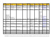
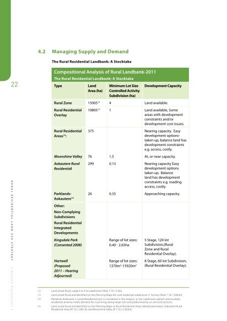
4.2 Managing Supply and Demand<br />
The <strong>Rural</strong> <strong>Residential</strong> <strong>Land</strong>bank: A Stocktake<br />
22<br />
Compositional Analysis of <strong>Rural</strong> <strong>Land</strong>bank-2011<br />
The <strong>Rural</strong> <strong>Residential</strong> <strong>Land</strong>bank: A Stocktake<br />
Type<br />
<strong>Land</strong><br />
Area (ha)<br />
Minimum Lot Size<br />
Controlled Activity<br />
Subdivision (ha)<br />
Development Capacity<br />
<strong>Rural</strong> Zone 15005 12 4 <strong>Land</strong> available.<br />
<strong>Rural</strong> <strong>Residential</strong><br />
Overlay<br />
<strong>Rural</strong> <strong>Residential</strong><br />
Areas 15 :<br />
10805 13 1 <strong>Land</strong> available, Some<br />
areas with development<br />
constraints and/or<br />
development cost issues.<br />
375 Nearing capacity. Easy<br />
development optionstaken<br />
up, balance land has<br />
development constraints<br />
e.g. access, costly.<br />
Moonshine Valley 76 1.5 At, or near capacity.<br />
RURAL RESIDENTIAL LAND USE STRATEGY [ Growth Projections ]<br />
Aokautere <strong>Rural</strong><br />
<strong>Residential</strong><br />
299 0.13 Nearing capacity Easy<br />
development options<br />
taken up. Balance<br />
land has development<br />
constraints e.g. roading<br />
access, costly.<br />
Parklands-<br />
26 0.35 Approaching capacity.<br />
Aokautere 14<br />
Other:<br />
Non-Complying<br />
Subdivisions<br />
<strong>Rural</strong> <strong>Residential</strong><br />
Integrated<br />
Developments<br />
Kingsdale Park<br />
(Consented 2008)<br />
Hartwell<br />
(Proposed<br />
2011 – Hearing<br />
Adjourned)<br />
Range of lot sizes:<br />
0.40 - 2.65ha<br />
Range of lot sizes:<br />
1370m 2 -15920m 2<br />
5 Stage, 120 lot<br />
Subdivision,(<strong>Rural</strong><br />
Zone and <strong>Rural</strong><br />
<strong>Residential</strong> Overlay).<br />
8 Stage, 60 lot Subdivision,<br />
(<strong>Rural</strong> <strong>Residential</strong> Overlay).<br />
12 <strong>Land</strong> zoned <strong>Rural</strong>, subject to 4 ha subdivision (Rule 7.16.1.2 (b))<br />
13 <strong>Land</strong> zoned <strong>Rural</strong> and identified on the Planning Maps for rural residential subdivision (1 ha lots) (Rule 7 16.1.2(b)(iii)).<br />
14 Parklands-Aokautere is zoned <strong>Residential</strong>, but is considered in this analysis, as the subdivision pattern and resultant<br />
residential amenity meets demand for rural living, being larger lots and predominantly un-serviced sections.<br />
15 <strong>Land</strong> zoned <strong>Rural</strong> and identified on the Planning Maps as <strong>Rural</strong> <strong>Residential</strong> Areas (dotted perimeter): Aokautere <strong>Rural</strong><br />
<strong>Residential</strong> Area (R7.16.1.2(b) (i)) and Moonshine Valley (R 7.16.1.2 (b)(ii)).