Exhibit C: Detailed Background, Work Group Recommendations
Exhibit C: Detailed Background, Work Group Recommendations
Exhibit C: Detailed Background, Work Group Recommendations

You also want an ePaper? Increase the reach of your titles
YUMPU automatically turns print PDFs into web optimized ePapers that Google loves.
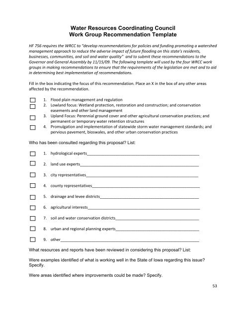
Water Resources Coordinating Council<br />
<strong>Work</strong> <strong>Group</strong> Recommendation Template<br />
HF 756 requires the WRCC to “develop recommendations for policies and funding promoting a watershed<br />
management approach to reduce the adverse impact of future flooding on this state's residents,<br />
businesses, communities, and soil and water quality” and to submit these recommendations to the<br />
Governor and General Assembly by 11/15/09. The following template will used by the four WRCC work<br />
groups in making recommendations to ensure that the requirements of the legislation are met and to aid<br />
in determining best implementation of recommendations.<br />
Fill in the box indicating the focus of this recommendation. Place an X in the box of any other areas<br />
affected by the recommendation.<br />
1. Flood plain management and regulation<br />
2. Lowland focus: Wetland protection, restoration and construction; and conservation<br />
easements and other land management<br />
3. Upland Focus: Perennial ground cover and other agricultural conservation practices; and<br />
permanent or temporary water retention structures<br />
4. Promulgation and implementation of statewide storm water management standards; and<br />
pervious pavement, bioswales, and other urban conservation practices<br />
Who has been consulted regarding this proposal? List:<br />
1. hydrological experts___________________________________________________<br />
2. land use experts______________________________________________________<br />
3. city representatives___________________________________________________<br />
4. county representatives_________________________________________________<br />
5. drainage and levee districts_____________________________________________<br />
6. agricultural interests___________________________________________________<br />
7. soil and water conservation districts______________________________________<br />
8. urban and regional planning experts______________________________________<br />
9. other_______________________________________________________________<br />
What resources and reports have been reviewed in considering this proposal? List:<br />
Were examples identified of what is working well in the State of Iowa regarding this issue?<br />
Specify.<br />
Were areas identified where improvements could be made? Specify.<br />
53
Were examples of best practices identified from the local or regional level in Iowa, or in<br />
other states, that should be considered for statewide implementation in Iowa?<br />
Outline how improvements can be made without legislative action.<br />
If legislation is needed, would it establish new law or revise existing law? (specify Code<br />
sections when possible)<br />
How would this proposal impact Iowans in a positive or negative way?<br />
What agencies does this proposal affect?<br />
Is this issue similar to any legislation that was filed in the past? What was the outcome?<br />
Are there interest groups or associations that support or oppose this proposal or will<br />
present similar proposals themselves?<br />
Funding considerations:<br />
• Multi-year state fiscal Impact (please be as specific as possible, including tax<br />
credits and any FTE adjustments).<br />
• Also, please identify funding source (General Fund or other funds),<br />
• whether the proposal includes one-time costs or multi-year costs,<br />
• and whether there are operating expenditures:<br />
54
DETAILED BACKGROUND: WORK GROUP 1, FLOOD PLAIN MANAGEMENT<br />
1. Flood Plain Management & Regulation <strong>Work</strong>group<br />
a. Introduction/scope of work<br />
FLOODPLAIN REGULATIONS:<br />
Put simply, Iowa’s flood plain regulations are not working as desired. Buildings, houses, fill and other<br />
development are placed in flood plains and floods continue to damage structures, threaten lives and<br />
cost taxpayers millions of dollars. Flood plains act as natural conduits for flood waters and further<br />
development impairs this natural function. We cannot stop floods but we can reduce the amount of<br />
damage and the threat to public safety. The state flood plain regulations should focus on protection of<br />
public safety, property, and the integrity of the flood plain.<br />
It would be impractical and unnecessary to prohibit all development in the flood plain. Some types of<br />
development such as youth ball fields, parks, trails and picnic areas are well suited for flood plains and<br />
do not impair the function of the flood plain. Development of this sort also does not have a high<br />
replacement or repair cost after a flood and does not increase the threat to public safety from flooding.<br />
Most agricultural uses are also appropriate uses of Iowa’s flood plains.<br />
Definitions<br />
♦ Floodway. The channel of a river or other watercourse and the adjacent land areas that must be<br />
reserved in order to discharge the flood without cumulatively increasing the water surface<br />
elevation of the 1% flood more than one foot. (A diagram is attached).<br />
♦ 0.2% Flood. Bigger floods happen less often than smaller floods. The size of a flood (the height of<br />
the flood water) can be described by the probability that it will occur in any year. Based on how<br />
frequently it has occurred in the past, the 0.2% flood has a 1 in 500 chance of occurring in any<br />
year. The probability of occurrence is the same regardless of how long it has been since a flood of<br />
that size has occurred.<br />
♦ 1% Flood. Bigger floods happen less often than smaller floods. The size of a flood (the height of<br />
the flood water) can be described by the probability that it will occur in any year. Based on how<br />
frequently it has occurred in the past, the 1% flood has a 1 in 100 chance of occurring in any year.<br />
The probability of occurrence is the same regardless of how long it has been since a flood of that<br />
size has occurred.<br />
<strong>Recommendations</strong>:<br />
♦ Recommendation #1: The 0.2% flood should be the regulated flood plain instead of the 1% flood.<br />
This change should be phased in as the 0.2% flood plains and floodways are identified on maps<br />
approved by the Federal Emergency Management Agency.<br />
♦ Recommendation #2: The state should prohibit development (structures, fill and other<br />
restrictions to flood flows) in the floodway of the regulated flood plain. Reconstruction of<br />
substantially damaged structures already located in the floodway should also be prohibited.<br />
♦ Recommendation #3: The use of fill to elevate new or reconstructed structures (excluding levees)<br />
in the flood plain should be restricted to no more than three vertical feet. Other means of<br />
elevating structures should be allowed. Structures in the regulated flood plain but outside the<br />
floodway should be constructed in a manner that will reduce the damage caused by the 0.2%<br />
flood. These restrictions should be phased in as the 0.2% flood plains are identified on maps<br />
approved by the Federal Emergency Management Agency.<br />
55
FLOOD CONTROL STRUCTURES (LEVEES):<br />
Flood control levees have been used for decades to reduce damage caused by flooding. However, levees<br />
do not eliminate the risks of flood damage. Levees have failed or been over‐topped in the past. When<br />
this happens the sudden rush of flood waters can cause more damage than floods in areas without<br />
levees. Still, when designed, built and maintained properly levees are effective tools for managing<br />
flooding.<br />
The Army Corps of Engineers has developed a comprehensive plan for controlling flooding on the upper<br />
Mississippi River which contains many alternatives. The report does not endorse any of the alternatives<br />
and congress has not appropriated funds to implement the plan. An existing levee system on the lower<br />
portions of the Mississippi River (below New Madrid, Missouri) was built with federal funds some years<br />
ago and financial support for maintenance continues today. Even without federal funding levee districts<br />
and communities in Iowa could use the plan to improve flood protection for their constituents. There is<br />
substantial value in developing local flood protection plans as part of a larger planning effort.<br />
♦ Recommendation #4: Areas on the landward side of a flood control levee recognized by the<br />
Federal Emergency Management Agency as protecting against the 0.2% flood should not be<br />
considered as in the 0.2% floodplain and should not be subject to the regulations for the 0.2%<br />
flood plain.<br />
♦ Recommendation #5: Flood control levees should primarily be used to protect areas with existing<br />
development if there are no practical alternatives for mitigating damage from floods.<br />
♦ Recommendation #6: The governor should support and endorse Alternative H in the “Upper<br />
Mississippi River Comprehensive Plan ‐ Final Report June 2008 (Revised Aug 14, 2008)” prepared<br />
by the Army Corps of Engineers. This alternative would improve the existing levee system to<br />
provide protection from the 0.2% flood along the Mississippi River (not the tributaries). [Note: The<br />
Army Corps of Engineers employees participating in the work group did not endorse any<br />
alternative.]<br />
The Federal Emergency Management agency is requiring flood control levees shown on their official<br />
maps to be certified in the next two years before the levees can be recognized as protecting against the<br />
floods for which they were designed. The certification process can be expensive and communities may<br />
not be able to bear that cost alone.<br />
♦ Recommendation #7: The state should create a grant program to help entities bear the cost of<br />
certifying existing flood control levees.<br />
♦ Recommendation #8: The state should create a grant program to assist entities with improving<br />
existing levees as one way to meet the new 0.2% flood regulations.<br />
PLANNING:<br />
The best flood plain management planning is done by the local community whether it be a city, county,<br />
watershed or river basin. Local officials such as zoning and building administrators, community planners<br />
and emergency management service providers will have the bulk of the responsibility for implementing<br />
these plans. Local flood plain management plans are the key to reducing exposure to flood damage.<br />
56
♦ Recommendation #9: The state should create a grant program to support local planning entities<br />
for developing local flood plain management plans. Preference should be given to planning<br />
activities that benefit a region or watershed. The goal of these flood plain management plans<br />
should be to reduce the flood exposure to people and property and thereby reduce flood<br />
damages.<br />
FLOOD RISK EDUCATON:<br />
The general public—including lenders, insurance professional and others—misunderstands the risks of<br />
building in a flood plain. It is common to hear someone state that the 1% flood occurs only once every<br />
one hundred years or to be dismayed with experts when they have seen more than one 100 year flood<br />
in their lifetime. This misunderstanding leads them to underestimate the risk of buying a house within<br />
the 1% flood plain without realizing that it has a 26% chance of being damaged in a 1% flood at least<br />
once before they can pay off a typical 30 year mortgage.<br />
Local flood plain managers and planners need training, also. The Department of Natural Resources was<br />
appropriated additional funds in 2009 and part of those funds will go toward improving communication<br />
between local managers and the department as well as increasing training for local officials.<br />
♦ Recommendation #10: The legislature and the governor should support the formation of a local<br />
chapter of the Association of State Flood Plain Managers in Iowa that would provide a vehicle for<br />
local managers and planners to discuss flood plain issues and learn from each other.<br />
♦ Recommendation #11: The Iowa State University Extension Service should be tasked with and<br />
appropriated funds for educating the general public about flood plains, flood risks and basic flood<br />
plain management principles. The ISU Extension Service already has a network of educators across<br />
Iowa and should develop materials and programs in consultation with flood plain experts.<br />
CRITICAL FACILITIES:<br />
Definitions:<br />
♦ Facility. Buildings or other structures, utilities, storage areas for equipment and materials.<br />
♦ Class I Critical Facility. A facility to which access must be maintained during a flood so the facility<br />
may continue to function. Examples of Class I Critical Facilities include emergency operation<br />
centers, communication centers and hospitals. Class I Critical Facilities also include facilities that<br />
are difficult or time consuming to evacuate during a flood such as jails, nursing homes and assisted<br />
living centers.<br />
Facilities that are critical to the health and safety of the public should be protected from flooding.<br />
Hospitals and emergency operation centers cannot maintain their function unless they are accessible<br />
during a flood. Jails and care centers can be difficult and time consuming to evacuate before and<br />
especially during a flood emergency. It is not enough for these types of facilities to be protected from<br />
flood waters. Access to these facilities must also be maintained. City halls, courts, record storage and<br />
similar facilities must be protected from flood damage but do not necessarily need to function during a<br />
flood. Relocating existing critical structures can be very expensive. When new critical structures are<br />
planned and designed, there is a genuine opportunity to reduce the damage from flooding and to<br />
ensure that their function can be maintained during a flood.<br />
♦ Recommendation #12: New Class I Critical Facilities should be located outside the 0.2% flood plain<br />
whenever practical. New Class I Critical Facilities should also be designed and located as to<br />
maintain their function during a 0.2% flood whenever practical.<br />
57
Stakeholder approval/opposition<br />
OTHER OPINIONS EXPRESSED:<br />
Whenever possible, the workgroup tried to reach consensus on the statements and recommendations.<br />
When consensus was reached it was rarely unanimous. Below are the viewpoints of those that did not<br />
necessarily agree with the statements and recommendations above.<br />
♦ Government should not impose restrictions on the use of property. Many citizens that live in a<br />
flood plain are aware of and have accepted the risks and do not expect any help from the<br />
government.<br />
♦ Flood control structures are not reliable enough to be used extensively in flood plain<br />
management. Any flood plain management strategy that uses structural flood controls in lieu of<br />
removing or flood proofing structures in the 0.2% flood plain is incomplete and will fail eventually.<br />
Structural controls do have their place—to protect existing development that cannot be mitigated<br />
in other ways. However, in many instances, structural controls are used because they are less<br />
intrusive and less costly and more effective mitigation measures.<br />
♦ The geographic boundaries and the economic impacts of delineating the 0.2% flood plain area as<br />
the regulated flood plain are currently unknown. A mapping project has been recently initiated<br />
that will produce flood maps for the entire state but it will not be completed and approved by<br />
FEMA for another five to seven years. The delineation of the 0.2% flood plains and floodways<br />
should be completed in order to educate property owners and local communities and to make an<br />
informed policy decision. Some in the workgroup believe that the policy decision to move to a<br />
0.2% regulated flood plain should wait until delineation of the 0.2% flood plains and floodways is<br />
completed and the impacts of this change analyzed before making a policy decision which will<br />
have an impact on the property rights of many Iowans including the value of their property and<br />
risk of flood damage.<br />
The workgroup realizes that the expanded or new policy recommendations made here have serious<br />
implications to the citizens of Iowa. Many residences and other buildings will have to be moved from the<br />
0.2% flood plain after being damaged rather than being rebuilt in their current location. New<br />
development in the 0.2% flood plain, while not prohibited by these recommendations, will be more<br />
difficult and expensive than it is now. But the goal of these recommendations is to reduce the damage<br />
caused by flooding and that cannot be accomplished without changes in how we manage our flood<br />
plains.<br />
Many of the workgroup members are representatives of different public interest groups. While the<br />
representatives participated with the full knowledge of the groups they represent, it should not be<br />
assumed that the groups or their representatives fully endorse the recommendations or statements<br />
made herein.<br />
b. Resources considered<br />
i. Documents<br />
Floodway Diagram<br />
58
DETAILED BACKGROUND: WORK GROUP #2, LOWLAND WORK GROUP<br />
DATE: 9/15/09<br />
Introduction/ Scope of <strong>Work</strong><br />
Lowland work group was convened to consider policy and funding options for strategies to reduce the<br />
impact of flooding with a focus on wetland protection, restoration, and construction; and conservation<br />
easements and other forms of land management.<br />
Examples of What is <strong>Work</strong>ing Well in Iowa<br />
Inter‐agency cooperation during floods and other emergency situations happens quickly in Iowa and<br />
with good results. Interagency coordination during disaster response and recovery operations has been<br />
dynamic between events with working arrangements that have evolved as identified in Iowa’s<br />
Comprehensive Emergency Plan.<br />
More recently, State and Federal interagency coordination on levee and floodplain recovery activities<br />
have been formalized through the Interagency Levee <strong>Work</strong> <strong>Group</strong> (ILWG) convened by the U.S. Army<br />
Corps of Engineers (USACE). A successor body, the Flood Risk Management Team (FRMT) begins<br />
ongoing coordination work in September 2009.<br />
The State Hazard Mitigation Team (SHMT) provides for interagency information sharing and<br />
dissemination related to the mitigation of all natural and man‐made hazards. The SHMT also invites<br />
Federal stakeholders and non‐governmental organizations to participate as needed. The SHMT focus<br />
includes but is not limited to flooding. SHMT member agencies form SHMT sub‐groups focus on specific<br />
issues as they arise.<br />
The recently‐convened Water Resources Coordinating Council (WRCC) is charged to provide interagency<br />
program coordination on water resource issues including those relating both to water quality (such as<br />
point and non‐point pollution) and quantity (water supply, flooding, etc).<br />
The USACE has initiated an Iowa/Cedar Watershed Study which is intended to provide an assessment of<br />
flood damage risks and contributing factors. This study is being conducted in cooperation with the<br />
FRMT, the WRCC, and their member agencies.<br />
Five other assessments are being done that will provide support to the USACE Iowa/Cedar study. Rapid<br />
Watershed Assessments (RWAs) have been or are being completed by the U.S. Department of<br />
Agriculture (USDA) Natural Resources Conservation Service (NRCS) on all the sub‐watersheds of the<br />
Cedar River Basin. This work will provide useful background information for the USACE study. In<br />
addition, the Department of Natural Resources (DNR) and NRCS are collaborating on a high‐cut<br />
assessment of all floodplains in Iowa to identify floodplain segments that should be top priorities for<br />
more detailed study and perhaps focused conservation easement program investments.<br />
The Federal Emergency Management Agency (FEMA) and Iowa Homeland Security and Emergency<br />
Management Division (IHSEMD) have helped communities reduce future flood damage risks through the<br />
404 and 406 Hazard Mitigation programs under the Stafford Act. These projects have included property<br />
acquisitions, flood proofing, structural relocation, and flood control projects to protect critical facilities.<br />
In communities like Cherokee, Des Moines, Cedar Falls and Independence, FEMA 404 Hazard Mitigation<br />
funds have enabled home and business owners to relocate from high‐risk areas, and helped<br />
communities convert former residential and business areas to useful but low‐risk green spaces.<br />
The FEMA 406 Hazard Mitigation program has helped local governments cover the cost of repairs to<br />
make infrastructure more resistant to flood damages during future flood events.<br />
The USACE and Iowa DNR, through their responsibilities under the Clean Water Act, and the Iowa DNR<br />
and local jurisdictions, through their responsibilities for floodplain regulation, provide opportunities for<br />
interagency comment and coordination on projects that are planned for or will affect floodplains. The<br />
Clean Water Act also provides for public input.<br />
60
Other state and federal programs that have shown success in Iowa include:<br />
• Technical and financial support is provided through the USACE to levee districts and<br />
communities that participate in its PL84‐99 ____________ Program. Program requirements<br />
require participating local sponsors to build and maintain levees to USACE standards, and in<br />
return the USACE provides technical and financial assistance in the event levees are<br />
damaged during flood events.<br />
The USACE also provides program and technical support to efforts aimed at encouraging<br />
non‐structural alternatives to levee repairs in the aftermath of 2008 flooding. This support<br />
was fed through the Regional Interagency Levee Task Force (now the Regional Flood Risk<br />
Management Team) and the Iowa FRMT. As a result, a non‐structural alternative (NSA) is<br />
being implemented at the Louisa Levee District 11. This NSA will make more efficient use of<br />
public dollars, provide for additional flood storage, improve wildlife habitat and decrease<br />
flood damage risks to two communities while maintaining flood damage protection to a<br />
locally important county highway. The Louisa LD11 project will provide an example and case<br />
study for future NSA projects throughout the Midwest.<br />
• Wetland mitigation banking provides for cost‐effective and science‐based mitigation for<br />
mitigating negative effects on wetlands from public infrastructure projects, private<br />
development and agriculture. The first wetland mitigation bank restored previously‐drained<br />
land in the Prairie Pothole area. Wetland banking can help expedite well‐planned projects<br />
that improve floodplain management. Safeguards need to be in place to avoid wetland<br />
banks being used to accommodate inappropriate development in floodplains.<br />
• The Wetland Reserve Program (WRP) is a voluntary program offering landowners the<br />
opportunity to protect, restore, and enhance wetlands on their property. The NRCS<br />
provides technical and financial support to help landowners with their wetland restoration<br />
efforts. The NRCS goal is to achieve the greatest wetland functions and values, along with<br />
optimum wildlife habitat, on every acre enrolled in the program. This program offers<br />
landowners an opportunity to establish long‐term conservation and wildlife practices and<br />
protection. There are ________ acres of WRP easements in Iowa, with approximately<br />
______% being located in floodplains.<br />
• The Emergency Watershed Protection (EWP) Program undertakes emergency measures<br />
including the purchase of flood plain easements for runoff retardation and soil erosion<br />
prevention to safeguard lives and property from floods, drought, and the products of<br />
erosion on any watershed whenever fire, flood or any other natural occurrence is causing or<br />
has caused a sudden impairment of the watershed. EWP Floodplain Easement funds<br />
allocated to Iowa as a response to 2008 flooding were focused in several floodplain<br />
corridors based on input provided by state agencies and non‐governmental organizations.<br />
Similar actions were taken after extensive flooding in 1993, which helped to establish the<br />
Iowa River Corridor and to enable the buy‐out of the former Levee District 8 in Louisa<br />
County.<br />
• The Conservation Reserve Program (CRP) administered by the USDA Farm Services Agency<br />
(FSA) has been very successful in providing year‐around cover. CRP enrollments have<br />
provided for localized increases in water infiltration. Soil conservation from well‐developed<br />
roots also decreases surface runoff and keeps water on the landscape.<br />
• Conservation Reserve Enhancement Program (CREP) is providing focused nitrate reduction<br />
benefits where it has been implemented. Around 35 projects are in place, with another 18<br />
under construction and another 70 in the process of being enrolled. Existing sites provide<br />
61
localized nitrate reduction and flood water attenuation benefits where they have been<br />
installed.<br />
• The U.S. Fish and Wildlife Service (FWS) Private Lands Program has been used to purchase<br />
the residual value of some land tracts that have been enrolled into USDA conservation<br />
easement programs. The FWS Private Lands Program has also been used to purchase some<br />
easements in high priority wildlife areas. These purchases have resulted in local floodplain<br />
land use changes and have provided for limited flood water storage. ________ acres have<br />
been purchased through the FWS Private Lands Program.<br />
• The PL83‐566 Watershed Protection and Flood Prevention (PL‐566) Program administered<br />
by the NRCS has a long history of flood damage reduction success in watersheds and<br />
communities across the state. These projects have provided other benefits including<br />
agriculture pollution control, erosion control, fish and wildlife habitat, water supply and<br />
recreation.<br />
PL‐566 authority is broad enough to provide for a variety of flood damage reduction<br />
approaches, including the purchase of floodplain easements, and the implementation of<br />
both structural and non‐structural upland run‐off reduction measures.<br />
• The Iowa Department of Economic Development (IDED) has recently required new<br />
development projects receiving IDED assistance to conform to Low Impact Development<br />
principles in an effort to reduce negative hydrologic impacts of development projects.<br />
• The Iowa Department of Transportation (IDOT) has water resources and engineering staff<br />
focused on water resource issues in order to better consider floodplain and wetland issues<br />
during project planning and implementation.<br />
Areas where improvements can be made:<br />
• The WRCC as authorized can be an effective body for interagency coordination. However, to<br />
this point the WRCC has not moved past information exchange to actual program coordination.<br />
There is a need for greater planning, program coordination and collaboration among state and<br />
federal agencies and local entities.<br />
• Consistently appropriate land use decisions in urban areas require rational zoning, skilled<br />
administrators, educated and ethical elected and appointed officials, and sustained political<br />
courage. The absence of any one of these traits may result (and has resulted) in poor land use<br />
decisions and increased risk of flood damages in the future.<br />
Improved land use management will require a more sustained commitment to local support,<br />
strengthened state regulations, and state staffing adequate to ensure accountability of local<br />
officials.<br />
• The NRCS in Iowa has given partner agencies and non‐governmental organizations the<br />
opportunity to nominate special project areas for focused WRP funding. This is a good practice<br />
and should be enhanced through planned and targeted WRP project areas (in addition to the<br />
self selection that already happens).<br />
• Planned, targeted CRP enrollments on critical portions of watersheds could be a tool (in<br />
combination with other upland strategies and improved floodplain management) to help reduce<br />
downstream flood damages. The CRP has a 10‐year renegotiable term, but it does not lock‐in<br />
perpetual land use through an easement or similar agreement. CRP rental rates have not risen<br />
to match farm land rental market values.<br />
62
• The CREP program has been implemented on a very limited scale relative to the overall need. It<br />
has not yet provided a significant reduction in nitrate concentrations on major Mississippi River<br />
tributaries and will not do so unless the concept is implemented extensively throughout the tiledrained<br />
areas of the state. CREP sites will not provide significant flood damage reduction<br />
benefits unless flood water detention is planned and provided for in CREP structure placement<br />
and designs.<br />
• Several state water resource programs are providing useful if limited assistance to water<br />
resource projects. Generally these programs have been focused on the maintenance of soil<br />
productivity or improving water quality. With a few exceptions, these programs have generally<br />
not focused on the floodplain management or flood damage reduction. State water resource<br />
programs include:<br />
o Department of Natural Resources (DNR):<br />
• 319 Program (EPA program administered by DNR)<br />
• Lake Restoration Program<br />
• Clean Water Revolving Fund<br />
o Iowa Department of Agriculture and Land Stewardship (IDALS)<br />
• Iowa Financial Incentives Program (IFIP)<br />
• Watershed Protection Program (WSPF)<br />
• REAP Water Protection Fund (WPF)<br />
The IFIP and WSPF programs could be targeted to focus more on upland run‐off<br />
reduction. However, there would be associated opportunity costs in the form of other<br />
objectives that would receive less attention than they are currently.<br />
• The Farm and Ranch Land Protection Program (FRPP) works well in Iowa but is<br />
underutilized. So far, only ____ acres have been protected through FRPP easements. This<br />
program provides matching funds to help purchase development rights to keep productive farm<br />
and ranchland in agricultural uses. <strong>Work</strong>ing through existing programs, USDA partners with<br />
State, tribal or other local governments and non‐governmental organizations to acquire<br />
conservation easements or other interests in land from landowners. USDA provides up to 50<br />
percent of the fair market easement value of the conservation easement.<br />
• The Grassland Reserve Program (GRP) works well in Iowa but is also underutilized. To date<br />
there are only _____ acres of land in Iowa covered by thirty‐year GRP easements. This is a<br />
voluntary conservation program that emphasizes support for working grazing operations,<br />
enhancement of plant and animal biodiversity, and protection of grassland under threat of<br />
conversion to other uses. Participants voluntarily limit future development and cropping uses of<br />
the land while retaining the right to conduct common grazing practices and operations related<br />
to the production of forage and seeding, subject to certain restrictions during nesting seasons of<br />
bird species that are in significant decline or are protected under Federal or State law. A grazing<br />
management plan is required for participants.<br />
The GRP could be used as a tool both for upland run‐off reduction and for floodplain<br />
management.<br />
• The Federal PL 83‐566 Watershed Protection and Flood Prevention (PL‐566) Program<br />
has a long history of flood damage reduction success in watersheds and communities across the<br />
state. However, appropriations for this program have dwindled such that only a relative few<br />
63
earmarked projects currently receive funding for new construction or for the rehabilitation of<br />
older project dams.<br />
Federal funds for planning new PL‐566 projects have not been available for several years. New<br />
planning currently underway in Iowa is being funded by local project sponsors that are primarily<br />
interested in the development of new surface water supplies.<br />
The PL‐566 program could provide a focused, flexible tool for managing local flood risks if it<br />
were funded adequately.<br />
• Existing water‐related programs are in different agencies. There is a need for a common<br />
clearinghouse for applicants to accommodate referrals to appropriate programs.<br />
• There is an apparent lack of understanding by the general public about flood threats, land use,<br />
and long‐term vs. short‐term needs. An example is the need for better public<br />
information/education in understanding risks relating to property being considered for<br />
purchase. Also, flood risk information is not readily available for individuals considering the<br />
purchase of property.<br />
• Continue to use EWP/WRP style easement programs to protect floodplains, but pursue<br />
partnerships to provide for expedited restoration, more focused management and more<br />
frequent monitoring.<br />
• The WRCC is not well staffed or equipped to ensure ongoing inter‐agency coordination including<br />
federal, state, NGO’s, private, and special teams.<br />
• Many agency program funding sources do not fit flood risk management. There is a need for<br />
program funding specific to flood damage reduction.<br />
• All too often, there is not an emphasis on response, recovery and mitigation planning until a<br />
disaster has occurred. Planning, responding and recovery begin at the local level. All levels of<br />
government need to help communities move towards more appropriate land use to reduce<br />
flood damage risks.<br />
• There are FEMA, USACE and NRCS authorities that could help implement community watershedbased<br />
plans. More state resources are needed for project planning and required non‐federal<br />
match.<br />
• The WRCC, SHMT and FRMT need to continue to integrate the efforts of “traditional” water<br />
resource agencies (USACE, DNR, etc.) with agencies such as IDOT and IDED whose activities<br />
impact water resources.<br />
• The Iowa Code in Chapter 161 (E and F) provides authorities for county boards of supervisors to<br />
provide local dollars and management frameworks for water and floodplain management.<br />
Current authorities need to be studied to identify needed modifications that would better<br />
provide for proactive local project development and implementation.<br />
• More needs to done to reconnect streams and rivers to their respective flood plains where it<br />
can be done while avoiding increased flood damage risks to critical infrastructure and vulnerable<br />
64
populations. In agricultural areas currently protected to some extent by levees, opportunities<br />
should be identified to allow for low velocity flood flows that would provide for flood water<br />
storage while minimizing cropland damage from concentrated, high‐velocity currents. The<br />
planned modifications of Louisa Levee District 11 may provide a case study for similar projects in<br />
the future.<br />
• Water needs to remain on the landscape within a watershed. The rapid drainage of surface<br />
runoff and subsurface flow needs to be reversed to mitigate the magnitude of peak flows. The<br />
landscape’s ability to store water can be increased through targeted placement of practices that<br />
infiltrate and retain surface runoff. These practices could reduce flooding from high‐frequency<br />
(smaller) storm events and be a useful complement to floodplain management strategies to<br />
manage flood damages from lower‐frequency (larger) storm events.<br />
• Good restoration planning and follow up is needed. It is common for large blocks of retired<br />
farmland in the floodplain to become monocultures of reed canary grass and other noxious<br />
weeds. This is only prevented with annual maintenance. Partnerships with DNR, TNC, private<br />
landowner groups (watershed groups) should be explored for monitoring, management and (in<br />
some cases) public access.<br />
At the same time, there is a need to examine the current state of knowledge on issues that<br />
could present unintended consequences from wetland restoration, water detention and other<br />
practices intended to reduce flood damage risks. Issues to examine might include bu are not<br />
limited to cyanobacteria, disease transmission, ecosystems changes and fate of nutrients.<br />
65
LOWLAND RECOMMENDATIONS<br />
PLANNING & COORDINATION:<br />
Recommendation #1: Provide funding for watershed project planning and the implementation and<br />
maintenance of high priority flood damage reduction projects.<br />
Required Action Not Including Legislation:<br />
Legislation Required: Chapter 161 A provides necessary authorities for this work.<br />
Impact to Iowans: High priority projects could be implemented without dependence on<br />
federal funding decisions.<br />
Agencies Affected: IDALS‐DSC, SWCDs, County governments, NRCS<br />
Interest <strong>Group</strong>s that Support or Oppose: Not aware of any.<br />
Funding Considerations: Annual funding of not less than $6.0 Million is recommended.<br />
Recommendation #2: The WRCC should move more quickly from information sharing to actual<br />
interagency program coordination.<br />
Required Action Not Including Legislation: None.<br />
Legislation Required: No legislation is required.<br />
Impact to Iowans: State and Federal program dollars would be used more effectively to<br />
address water resource issues.<br />
Agencies Affected: All WRCC agencies.<br />
Interest <strong>Group</strong>s that Support or Oppose: Not aware of any.<br />
Funding Considerations:<br />
Recommendation #3: Provide interagency assessment and project planning to support and inform<br />
infrastructure / easement / land purchase investment decisions in floodplain areas.<br />
Required Action Not Including Legislation: Flood plain assessment work is underway by<br />
DNR and NRCS.<br />
Legislation Required: No legislation is required.<br />
Impact to Iowans: More cost efficient and effective investment decisions by state and<br />
federal agencies. Easement program funds might be less available for applicants outside of<br />
targeted areas.<br />
Agencies Affected: DNR, IDOT, IDED, NRCS, FSA, USACE, U.S. Dept of Housing and Urban<br />
Development (HUD), U.S. Economic Development Administration (EDA), Federal Highway<br />
Administration (FHWA)<br />
Interest <strong>Group</strong>s that Support or Oppose: The Nature Conservancy supports.<br />
Funding Considerations: Would require increased or redirected funding for coordinated<br />
planning.<br />
66
NON‐STRUCTURAL:<br />
Recommendation #4: Reconnect streams and rivers to their flood plains and floodways. This<br />
practice involves the modifications of levees, roads, channels and diversions. The State of Iowa<br />
should consider levee district buyouts when they are needed in order to accomplish streamfloodplain<br />
reconnections.<br />
Required Action Not Including Legislation: This could be done with local interagency<br />
coordination combined with the use of state and federal conservation and transportation<br />
programs.<br />
Legislation Required: Changes modifying Iowa Code Chapter 161A for easier establishment<br />
of SWCD watershed and flood prevention sub‐districts and for greater property tax revenue<br />
would be needed. Modify Chapters 161E and 161F for easier establishment and greater<br />
property tax revenues for soil conservation and flood control districts.<br />
Impact to Iowans: Floodplain land values would be lowered in some locations. Some<br />
communities located in floodplains could be more exposed to flooding. Other communities<br />
could experience reduced flood damage risks if peak flows are reduced as a result of<br />
increased temporary floodplain storage. Increased recharge of all alluvial aquifers,<br />
appropriate and lower risk land use, more sediment and nutrients trapped, and increased<br />
wildlife habitat and biodiversity.<br />
Agencies Affected: Metropolitan Planning Organizations, Regional Planning Authorities<br />
County governments, County Conservation Boards (CCBs), SWCDs, DNR flood plain<br />
management, Iowa Flood Center, FEMA (404 & 406), IDED (CDBG), CRNS, NRCS‐(EWP &<br />
WRP), FSA (CRP)<br />
Interest <strong>Group</strong>s that Support or Oppose: INHF ‐support<br />
Funding Considerations: Infrastructure modification would require funds for planning and<br />
construction. Anticipated public service savings, including savings from reduced<br />
infrastructure maintenance, would be evaluated as part of levee district buyout decision<br />
making.<br />
Recommendation #5: Drainage Water Management to allow for the seasonal retention of water in<br />
tile drained fields should be supported technically. This practice is most easily adopted in very flat<br />
landscapes.<br />
Required Action Not Including Legislation: This practice could be promoted within existing<br />
authorities.<br />
Legislation Required: None.<br />
Impact to Iowans: This practice could reduce nitrate losses from fields to streams. This<br />
practice could increase peak runoff if significant rainfall or snowmelt occurs while soils are<br />
still saturated.<br />
Agencies Affected: ISU Extension<br />
Interest <strong>Group</strong>s that Support or Oppose: Des Moines Water <strong>Work</strong>s Supports<br />
Funding Considerations: Installation could be done as an alternative to other subsurface<br />
drainage work.<br />
67
Recommendation #6: Provide authority for the purchase of easements in upland areas that are part<br />
of planned flood risk reduction projects. The easements would stipulate the use of water infiltration<br />
practices that are appropriate for each situation. Practices might include contour farming, strips of<br />
perennial vegetation, ponds, wetlands, no‐till, and other measures.<br />
Required Action Not Including Legislation: None.<br />
Legislation Required: An authority and funding stream would need to be established.<br />
Impact to Iowans: Run‐off reduction for high frequency rain events could be gained in<br />
selected areas.<br />
Agencies Affected: IDALS‐DSC<br />
Interest <strong>Group</strong>s that Support or Oppose: Not aware of any.<br />
Funding Considerations: Funds would need to be provided by the State for this purpose.<br />
Recommendation #7: Provide a means of indemnification that would allow levees to be modified or<br />
removed and floodplains to be farmed with the agreement that if there is flooding the land will be<br />
used for back up and holding water.<br />
Required Action Not Including Legislation: None.<br />
Legislation Required: An authority and funding stream would need to be established.<br />
Impact to Iowans: Flood storage could be gained in selected areas that would benefit critical<br />
infrastructure and/or vulnerable populations.<br />
Agencies Affected: DNR<br />
Interest <strong>Group</strong>s that Support or Oppose: Not aware of any.<br />
Funding Consideration: Indemnification would be compared to costs of other flood damage<br />
risk reduction options.<br />
PROJECTS:|<br />
Recommendation #8: Integrate multi‐purpose wetlands into watersheds with drainage districts or<br />
larger drainage systems. Systems would be retrofitted to enable nutrient trapping and treatment;<br />
more water infiltration and evapotranspiration; greater retention of run‐off; and habitat to support<br />
biodiversity. Maintain a holistic view of watershed management and targeting funds and programs<br />
within those watersheds.<br />
Required Action Not Including Legislation: Action by county boards of supervisors with<br />
help from county engineers, county conservation boards and soil and water conservation<br />
districts (SWCDs). IDALS‐DSC with assistance from the State Soil Conservation Committee.<br />
Help for coordination, technical planning, engineering design, use of conservation programs,<br />
and tax incentives; watershed planning and wetland mitigation. State financial assistance<br />
leveraged with federal conservation funds. NRCS through the WRP and FSA through the CRP<br />
(as well as the enhancement programs allowed for both programs.)<br />
Legislation Required: None. This action could be accomplished through a transition of<br />
alternative drainage and CREP budgets to support DSC efforts. It would also require<br />
redirection of some WRP and CRP funds by NRCS and FSA respectively.<br />
68
Impact to Iowans: Costs for monitoring and planning. Water quality improvements.<br />
Potential improvements in wildlife habitat. Potential for increased cyanobacteria blooms<br />
due to the introduction of high nutrient water in the wetland, increased wetland water<br />
storage capacity.<br />
Agencies Affected: Individual drainage districts and county governments, IDALS‐DSC, IDNR,<br />
NRCS, FSA, U.S. Fish and Wildlife service, EPA<br />
Interest <strong>Group</strong>s that Support or Oppose: Iowa Drainage District Association and Iowa Land<br />
Improvement Association support. Other state and federal agencies are working with IDALS<br />
to develop pilot projects to refine this concept.<br />
Funding Considerations: Could be funding‐neutral for the public once any research and<br />
evaluation is complete if existing wetland restoration programs are redirected for this<br />
purpose. If done as part of drainage infrastructure replacement, costs would be borne by<br />
drainage district landowners to cover required mitigation.<br />
Recommendation #9: Develop, implement, monitor and document a watershed project that has as<br />
a primary goal high infiltration of rainfall under non‐saturated soil moisture conditions in both rural<br />
and urban areas.<br />
Required Action Not Including Legislation: None.<br />
Legislation Required: None.<br />
Impact to Iowans: Primary impacts are rural and on cropland.<br />
This could demonstrate reduced negative impacts from high‐frequency rainfall events and<br />
benefits to soil quality.<br />
Agencies Affected: DNR, IDALS, NRCS. Most crop producers not already using<br />
comprehensive conservation systems will need significant technical assistance to comply<br />
with this requirement.<br />
Interest <strong>Group</strong>s that Support or Oppose: Not aware of any.<br />
Funding Considerations: Funding needs are not the biggest barrier for this action.<br />
Practices to achieve this requirement would be low cost UNLESS land use changes are<br />
needed.<br />
Recommendation #10: Conduct a cooperative pilot project for the evaluation of strategies for<br />
reducing severe scour erosion and sand deposition by floodwaters under various soils/geology<br />
conditions. Strategies would include but are not limited to levee and road modifications,<br />
reforestation and grassland seeding. This project should be part of an overall watershed plan at the<br />
HUC 8 scale or larger.<br />
Required Action Not Including Legislation: Flood Risk Management Team (FRMT) to<br />
facilitate coordination of work by USACE, NRCS and FSA. NRCS through the Wetlands<br />
Reserve Program and FSA through the Conservation Reserve Program (as well as the<br />
enhancement programs allowed for both programs.)<br />
Legislation Required: None.<br />
Impact to Iowans: Could provide information on strategies that could be used state‐wide.<br />
69
Agencies Affected: USACE, NRCS, FSA, DNR, County governments, County conservation<br />
boards (CCBs), SWCDs, Drainage and levee districts, Iowa Flood Center<br />
Interest <strong>Group</strong>s that Support or Oppose: Iowa Natural Heritage Foundation (INHF) ‐support<br />
Funding Considerations: Funds used for reforestation or permanent seeding would likely be<br />
drawn from other conservation priorities. Sources for funding of levee modifications are yet<br />
to be identified.<br />
Recommendation #11: Enhance WRT, EWP, FRPP, and CRP programs with state matching funds.<br />
Required Action Not Including Legislation: Existing state authorizes could be used.<br />
Legislation Required: Allocated state matching funds to leverage maximum usage of federal<br />
dollars.<br />
Impact to Iowans: Could provide for more targeted land management; could result in more<br />
public land ownership.<br />
Agencies Affected: DNR, IDALS‐DSC<br />
Interest <strong>Group</strong>s that Support or Oppose: Not aware of any.<br />
Funding Considerations: Would require not less than $5.0 million annually.<br />
EDUCATE & INFORM:<br />
Recommendation #12: Include floodplain or alluvial soils information as part of the disclosure form<br />
used as part of real estate transactions.<br />
Required Action Not Including Legislation: None.<br />
Legislation Required: This action will require legislative action and modification of related<br />
regulations.<br />
Impact to Iowans: Real estate buyers will be able to make more informed purchase<br />
decisions.<br />
Agencies Affected: County recorders, DNR, SWCDs, NRCS<br />
Interest <strong>Group</strong>s that Support or Oppose:<br />
Funding Considerations: Implementation costs are minor.<br />
Recommendation #13: “I‐Farm” is a farm resource management and business planning tool<br />
developed at ISU. I‐Farm could help farmers plan and create infiltration systems to accommodate<br />
one inch rainfalls. I‐Farm should be used by ISU Extension and other agencies to support<br />
conservation and business planning.<br />
Required Action Not Including Legislation: This tool could be used within existing<br />
authorities.<br />
Legislation Required: Allocate funds for education program.<br />
Impact to Iowans: The tools could benefit farmers by helping them make better business<br />
and resource management decisions.<br />
70
Agencies Affected: ISU Extension, IDALS‐DSC, NRCS<br />
Interest <strong>Group</strong>s that Support or Oppose: ISU Extension Supports<br />
Funding Considerations: Funds to provide for more extensive I‐Farm education would be<br />
needed.<br />
Resources and Reports Reviewed and Considered:<br />
• 2001 Iowa Watershed Taskforce Report, IDALS<br />
• Green Paper: Recovering from the Storms, Planning for the Future: A Safer, Smarter, Stronger<br />
Iowa, Rebuild Iowa Office<br />
• NRCS Wetland Conservation Easements Map – Iowa as of July 1, 2009<br />
• 2008 State of Iowa Maps (3)<br />
• County WRP Easements<br />
• County ERP Easements<br />
• County EWRP Easements<br />
• Farm Bill 2008:<br />
o At a Glance Wetlands Reserve Program<br />
o At a Glance Grassland Reserve Program<br />
• Farm and Ranch Lands Protection Program<br />
The Following Experts Have Been Consulted:<br />
• Hydrological: Rob Middlemis‐Brown<br />
• Land Use: Marty Adkins<br />
• City Representatives: Duane Sand, Dennis McAllister<br />
• County Representatives: Nate Bonnett<br />
• Drainage and Levee Districts:<br />
• Agricultural Interests: Darrel McLaren<br />
• Soil and Water Conservation Districts: Jean Eells<br />
• Urban and Regional Planning Experts: Scott Marler<br />
• Other: Jennifer Filipiak, Steve Zimmerman, Tom Oswald, Annette Mansheim<br />
71
DETAILED BACKGROUND: WORK GROUP 3, UPLAND WORK GROUP<br />
MINUTES<br />
Attendees:<br />
<strong>Work</strong> <strong>Group</strong> #3 Uplands of the<br />
Flood Plain Management Subcommittee<br />
of the Water Resources Coordinating Council<br />
August 20, 2009<br />
9:30 AM<br />
Rebuild Iowa Office, Conference Room 2<br />
Wallace Building<br />
502 E. Ninth Street, 2 nd Floor<br />
Des Moines, IA 50319<br />
<strong>Work</strong> <strong>Group</strong> Members:<br />
Tom Oswald, HSEMD, <strong>Work</strong> <strong>Group</strong> Chair<br />
Leah Maass, producer<br />
Rick Cruse, Iowa Water Center<br />
John Goode, Monroe County Engineer<br />
Kirk Siegle, Iowa Corn Growers<br />
Paul Assman, Crawford County Engineer<br />
Jim Gillespie, IDALS<br />
Larry Weber, IIHR – U of Iowa<br />
Witold Krajewski, Iowa Flood Center – U of Iowa<br />
Jeri Neal, Leopold Center for Sustainable Agriculture<br />
John Myers, NRCS<br />
Ken Tow, Rebuild Iowa Office<br />
Susan Judkins, Rebuild Iowa Office<br />
Linda Kinman, Des Moines Water <strong>Work</strong>s<br />
Steve Hopkins, DNR<br />
1. <strong>Work</strong> <strong>Group</strong> Chair Tom Oswald welcomed the group. The minutes of the 8/5/09 meeting<br />
were approved.<br />
2. The order of the agenda was revised slightly to prepare A‐V equipment. The Chair reviewed<br />
a matrix of prior recommendations from the Iowa Watershed Taskforce (2001), the Iowa<br />
Water Summit (2003), and the Watershed Quality Planning Task Force (2007). The matrix is<br />
posted on the WRCC Resources page of the Rebuild Iowa Office web site.<br />
http://www.rio.iowa.gov/wrcc/assets/flood_plain_prior_recommendations.pdf<br />
3. The chair also discussed the concept of field level conservation planning systems.<br />
4. Witold Krajewski from the U of I presented a Power Point (posted to the RIO web site at<br />
http://www.rio.iowa.gov/wrcc/assets/Krajewski‐08202009‐WG3.pdf) and led a discussion<br />
72
about potential flood mitigation from upland structures. He referenced the concept of<br />
“distributed storage,” which involves many small water storage structures instead of a large<br />
reservoir. To be viable, the system must be controllable – an active system. Multiple<br />
objectives direct the “best” decisions on activating the system – generating the question of<br />
who decides? The entire drainage network in a watershed, including both rivers and<br />
streams, is key. The City of Palo is considering distributed storage. Water in their basin<br />
travels about three miles per hour. Flooding is a confluence issue. Sometimes a “traffic jam”<br />
occurs in a drainage system, and that’s exactly what caused the 2008 Cedar Rapids flood<br />
when a storm dropped water on top of an already filled system.<br />
Paul Assman, Crawford County Engineer, said that holding even some water provides some<br />
benefit. This was proven with the retention structures in Crawford County that prevented<br />
flooding in 1993. The construction cost was covered as follows: state 75%, county 12.5%,<br />
city 2.5%, landowner 10%.<br />
Larry Weber from the U of I said that 500,000+ acre feet of storage would be needed to<br />
have protected Cedar Rapids from the 2008 flood, based on a recent study.<br />
John Goode, Monroe County Engineer, said four counties (Appanoose, Wapello, Monroe<br />
and Davis) are affected by the Soap Creek watershed retention project that has been going<br />
on for 30 years. This is a passive project (no human intervention required), with<br />
approximately 10 acres of storage per retention structure. He feels the impact of the project<br />
has been positive and “tremendous.”<br />
Kirk Siegle commented that landowners will probably want access to any retained water on<br />
their land for livestock or irrigation use.<br />
Larry Weber and Witold Krajewski from the U of I said the potential water storage capacity<br />
in various parts of the state is not yet known but is being researched.<br />
Ken Tow agreed that flooding is a confluence issue and reminded the group that Coralville<br />
and Louisa County experienced confluence problems during the 2008 flood.<br />
Consensus was reached to recommend a demonstration project or project, also to be<br />
potentially called a “priority watershed” or pilot project. LIDAR mapping being conducted by<br />
the DNR is 90% complete and can inform the potential site selections. John Myers<br />
recommended that a watershed be selected and an active project begun, not just continue<br />
studying. We will need to decide if the project should handle an event at 2008 levels, or by<br />
some other measure. Other questions involve what can be done within reason, and can and<br />
should myths be dispelled.<br />
Paul Assman said, “In Crawford County, we ‘did’ instead of studying and we know it works.”<br />
He advised the group to be careful with any recommendations involving dredging; “We’re<br />
seeing the results of that in Western Iowa.” He said a decision needs to be made on what is<br />
socially and economically acceptable.<br />
73
Larry Weber suggested that a project needs the flexibility to start small but to go to a larger<br />
scale.<br />
Jeri Neal of the Leopold Center urged that the group consider dispelling myths such as “it<br />
will never happen again” or “we can control the flooding,” and doing our best to explain<br />
what we’ll get from a demonstration project the next time we do flood. The group agreed<br />
that a wealth of information has been generated from PL‐534 and PL‐566 in Western Iowa.<br />
Jim Gillespie from IDALS reminded the group that not all flooding is an “Upland” (<strong>Work</strong><br />
<strong>Group</strong> #3) problem and project planners will need to look downstream to the Lowlands.<br />
Linda Kinman from Des Moines Water <strong>Work</strong>s recommends forming a picture of what Iowa<br />
will look like and at what cost when outlining a proposed project. Jim Gillespie said a scale<br />
model would be helpful. Larry Weber thinks more information is needed to determine the<br />
“sweet spot” that would be the best site for a demonstration project. John Goode said a<br />
place should be chosen where the benefit will be obvious and can be measured in a positive<br />
direction. Witold Krajewski said that’s the problem with the scale of the project since the<br />
network controls what happens in the flatlands. In order to say if something works, we will<br />
need a “hybrid” model – academics will study and practitioners will implement, and they<br />
need to work together.<br />
Tom Oswald of HSEMD reminded that group that Lyle Asell of the DNR often said, “What<br />
does it do to fishing? That’s what people will ask.”<br />
Steve Hopkins of the DNR said that funding is available for impaired waters, so if a<br />
demonstration area can be identified where impaired waters exist and improvements can<br />
be documented, that will enable a funding source to assist with the project.<br />
The group agreed that there could be benefits from identifying a site in the Iowa/Cedar<br />
Basin since it was heavily impacted in 2008, including that it would take advantage of other<br />
studies already underway in that area as a result of the flooding. John Myers suggested that<br />
an area with existing retention structures that could be supplemented with additional<br />
structures could be a good choice.<br />
Kirk Siegle mentioned that development means municipalities don’t act like a sponge as<br />
farmland does, which has impact downstream. Tom Oswald said the Storm Water <strong>Work</strong><br />
<strong>Group</strong> #4 is focusing on this issue.<br />
Witold Krajewski said it would be useful to gather information on soil moisture. A 70‐<br />
square‐kilometer area drains through Palo, and a fast moving river can impede drainage of a<br />
small creek, causing it to back up and flood.<br />
Tom Oswald said many groups should be involved in recommending a site and studying the<br />
impacts, including the agricultural community, livestock groups, cities, state agencies and<br />
universities. Targeted funding and research should be sought. Linda Kinman suggested<br />
adding water, waste water, and rural water interests to the list. Ken Tow said the NRCS and<br />
74
DNR are looking at HUCS in conducting a rapid watershed assessment for the state, helping<br />
to identify risk.<br />
Factors in identifying a site should include potential storage capacity, ability to both<br />
implement and study, ideally in the Iowa/Cedar basin, a community that was impacted in<br />
2008 yet somewhat isolated (i.e. the top of the watershed) to quantify results, ability to<br />
collect soil moisture data, an area with a gaging station or recommend installation of a gage<br />
in the area, and an area where cities, utilities, and drainage districts will participate<br />
voluntarily. The merits of an active vs. passive system were discussed again.<br />
Education will be an important component of any project. The public will want to believe<br />
that something will help without understanding all of the complexities. Linda Kinman<br />
suggested that an institution like the Science Center of Iowa could install a rainfall<br />
simulation model to assist with education. Witold Krajewski said even zooming in with<br />
Google Earth allows one to realize the impact of a drainage area.<br />
Tiling issues were discussed. Rick Cruse of the Iowa Water Center asked if studies exist on<br />
the impact of tile. Linda Kinman said tile may speed flow and short‐circuit the ability of soils<br />
to remove contaminants, and agreed that we need to know more about the benefits and<br />
consequences of tile drainage. Kirk Siegle stated that tile allows a more controlled flow of<br />
runoff from agricultural fields which may allow the soil to act as a sponge, thereby reducing<br />
some flow – a give‐and‐take impact. John Goode asked if tiles could be replaced with a<br />
structure that would impede the water flow. Perhaps some storage could be achieved from<br />
natural ponds. Jim Gillespie commented that some drains are overtaxed and not draining<br />
properly. Steve Hopkins asked if a targeted retrofit could help. Tom Oswald said<br />
compensation should be considered for crop loss and inconvenience. Leah Maass suggested<br />
looking at using existing programs for taking land out of production; Kirk said perhaps CRP<br />
around intakes might be an idea. Leah said she knows of perfect areas to try that.<br />
Complications could result with Farm Service Agency (FSA); we need to understand the<br />
political and regulatory impacts. Tom Oswald expressed a preference for planning for a<br />
resource, identifying the needs for that resource, then identifying the potential funding<br />
sources including existing programs. Resources include people (i.e. landowners). John<br />
Goode agreed that resource planning is critical, and Leah said NRCS boundaries would be<br />
the ideal boundaries.<br />
5. Jeri Neal of the Leopold Center and Rick Cruse of the Iowa Water Center briefly discussed<br />
research needs. Many of today’s decisions are based in a soil survey conducted in the<br />
1950’s, with soil types drawn in arbitrarily based on slopes, etc. Updated information is<br />
needed as today’s needs are more sophisticated. Jeri suggested that we consider how to<br />
make data into a community education tool.<br />
6. Jim Gillespie from IDALS provided an update on perceived soil conservation needs, which<br />
include planning and development, resources, and people. They especially need the “right”<br />
people with the education and background to work with NRCS and hydrologists to provide<br />
engineering and technical assistance. Knowledge of new tools like LIDAR is important.<br />
75
7. Discussion was held on the HF756 requirement to consider perennial ground cover and<br />
other agricultural conservation practices. Handouts were distributed from Roger Wolf of the<br />
Iowa Soybean Association (in absentia)<br />
http://www.rio.iowa.gov/wrcc/assets/Flood_Landscape_Paper.pdf and John Myers of the<br />
NRCS. The current corn/bean rotation may not be sustainable beyond 100 or more years.<br />
Perennials improve soil quality and infiltration. Perhaps increasing the soil conditioning<br />
index (SCI) could be used as a tool, but Rick Cruse pointed out that once the profile is full,<br />
runoff will occur during a catastrophic flood to SCI is a long‐term measure.<br />
Witold Krajewski reiterated the need for more education, suggesting that that a media<br />
campaign should be undertaken to convey the complexity and integral nature of being<br />
prepared, water quality, and quality of life. He participated in another meeting where it was<br />
suggested that ISU Extension would deliver the message while others would develop the<br />
materials, but ISU Extension resisted since they felt the message was so complex that it<br />
required more specific background than their professionals possess. Linda Kinman said that<br />
members of the Water Quality Task Force have also recommended a media campaign,<br />
including a distribution to organizations to share with members. John Myers commented<br />
that people will forget the flood soon, and a media campaign will help them to remember.<br />
John Goode said his experience in Monroe County underscores that a good perennial<br />
ground cover can keep the ditches from filling, and the size of culverts can be reduced. Kirk<br />
Siegle said perennial ground cover issues boil down to economics since the cover can only<br />
be used by cow‐calf operations, and there are dwindling numbers of those in Iowa.<br />
Absentee landlords are also an issue; since operators aren’t guaranteed to continue past the<br />
current year’s operation, they can’t afford to sink costs into conservation practices. John<br />
Goode pointed to the water quality degradation that occurred at Lake Rathbun after<br />
switchgrass was taken out as a reason to incentivize growing switchgrass. Leah Maass said<br />
people need to understand how things work, not just on their land but in their region. She<br />
mentioned a program for women (now the largest percentage of landowners and many of<br />
whom are absentee) about not just renting out their property but caring for the land for<br />
long‐term benefit. John Myers said that landowners work under so many rules, such as<br />
those from FSA, but we need to find a way to get stewardship back in the forefront and he’s<br />
unsure how to do that. Rick Cruse said a landowner will have the long‐term benefit from<br />
stewardship, and shouldn’t just think about the rent check from tenant farmers. Perhaps<br />
there can be an effort to match owners with tenants for better conservation. Kirk Siegle<br />
agrees that property is farmed that shouldn’t be, but no till and other farming methods help<br />
to prevent some erosion. We have a problem looking long‐term since legislators and<br />
bankers only look at a year or two at a time.<br />
8. Engineering issues were covered throughout today’s discussion by Paul Assman of Crawford<br />
County and John Goode of Monroe County, so won’t be repeated in the interest of time.<br />
9. Steve Hopkins of the DNR provided a handout outlining watershed project steps. He said the<br />
same steps might hold true for a “watershed flood project.” He recommends 25,000 –<br />
30,000 acre and smaller watershed projects “because that’s where impact can happen.” He<br />
highlighted a need to partner with the NRCS, IDALS, Division of Soil Conservation and others<br />
in any way to leverage funding. It’s usually best to have a project coordinator on the ground.<br />
76
It is hoped that outcomes include water quality improvement. Once a project is in place,<br />
both modeling and monitoring are beneficial. Many projects are reviewed for three to four<br />
years, but longer monitoring is needed up to 25 years or more. Currently, projects are often<br />
initiated by local members of the Division of Soil Conservation. Tom Oswald said locally led<br />
projects are often a key to success. Leah Maass agrees with the need for local buy‐in. it<br />
helps to understand that everyone within a watershed counts. Unsewered communities<br />
have had some of the most successful projects to date.<br />
10. Ken Tow of the Rebuild Iowa Office reviewed the benefit of coordinating program planning<br />
and efforts. The RIO Green Paper on Smart Planning responds to a recommendation from<br />
the Rebuild Iowa Advisory Commission that we need a renewed emphasis on planning at all<br />
levels. Federal partners are important in this effort. We may need a week‐long facilitated<br />
process to identify needed improvements.<br />
11. Participants briefly reviewed <strong>Work</strong> <strong>Group</strong> members’ submissions regarding issues outlined<br />
in the “recommendation template” (see<br />
http://www.rio.iowa.gov/wrcc/assets/WRCC_Recommendation_Template.doc) for issues to<br />
be submitted to the Water Resources Coordinating Council for their consideration prior to<br />
submitting recommendations to the legislature and governor. Tom Oswald recommended<br />
that all prior recommendations from 2001, 2003 and 2007 be incorporated into the 2009<br />
recommendations. Rick Cruse expressed a concern that the prior recommendations are<br />
more water quality focused. Tom Oswald and Susan Judkins will compare recommendations<br />
generated from <strong>Work</strong> <strong>Group</strong> #3 to the prior recommendations to identify the best mix.<br />
12. Review of <strong>Recommendations</strong> from <strong>Work</strong> <strong>Group</strong> #3<br />
Reserving the right to thoroughly review the minutes to add anything that has been missed,<br />
the following general recommendation ideas were identified as having been generated<br />
today:<br />
• A “hybrid” demonstration project involving both implementation and study should<br />
be identified based on specified criteria<br />
o Capture distributed storage as a concept for the project<br />
o Include impaired waters as a criterion to enable some funding<br />
o A tax on municipal water, sales tax on bottled water, and/or collecting a fee<br />
on bottled water similar to pop bottles could serve as additional funding<br />
sources<br />
• Information should be generated on tiling, potholes and ponds<br />
• We need better soil survey data and soil mapping<br />
o A soil moisture monitoring network is needed<br />
o The Soil Conditioning Index should serve as a tool<br />
• Education and a media campaign are needed<br />
o Landowner/tenant issues should be considered as part of this campaign<br />
• John Myers suggested that climate change should be considered as a factor in the<br />
possible need to reassess criteria for conservation practices more frequently<br />
o<br />
o<br />
Criteria are included in the Field Office Technical Guide<br />
Conservation criteria are revised every five years, but design criteria may<br />
need to be revised also<br />
77
o Storm likelihood needs to be considered; the current basis of a “ten‐yearstorm”<br />
should be analyzed for accuracy of predictions<br />
• Recommend continued State funding of the Iowa Flood Center<br />
• Jim Gillespie reminded the group that a 2010 referendum will decide if threeeighths<br />
of a cent of the money raised by a future increase in state sales tax would go<br />
to a new protected account for natural resources projects, including soil and water<br />
conservation, and parks and trails. It is expected that such funding would generate<br />
$150 million annually and this could serve as a funding source.<br />
• All prior recommendations from 2001, 2003 and 2007 will be considered for<br />
inclusion in the recommendations from 2009<br />
13. Future Meetings<br />
Minutes, including a list of recommendations, will be forwarded to <strong>Work</strong> <strong>Group</strong> Members.<br />
An optional meeting date will be set f necessary, perhaps on 9/3/09. <strong>Work</strong> <strong>Group</strong> members<br />
may attend the next WRCC Subcommittee for Flood Plain Management <strong>Recommendations</strong><br />
at 10 AM on 9/11/09, or the full WRCC Committee meeting at 1 PM on 9/11/09. Attendance<br />
will be encouraged at public meetings that are planned for 9/22/09 in Storm Lake, 9/24/09<br />
in Lewis and Ankeny, 9/29/09 in Mount Pleasant and West Branch, and 10/1/09 in Waverly.<br />
14. Public Input – None as no public representatives were in attendance. Public input will<br />
continue to be encouraged at upcoming meetings.<br />
15. Meeting adjourned at 1:55 AM.<br />
78
Water Resources Coordinating Council<br />
<strong>Work</strong> <strong>Group</strong> #3 Recommendation<br />
Upland Focus: Perennial ground cover and other agricultural conservation practices; and<br />
permanent or temporary water retention structures<br />
c. Introduction/scope of work<br />
d. What is working well in Iowa<br />
• Crawford County/East Boyer Watershed – Tom contact Lynn Betts<br />
• Soap Creek Watershed in SE Iowa – Tom contact John Goode<br />
• Conservation and agronomic practices that are matched to the need of the land and<br />
objective of the landowner will improve sustainability over the long term, potentially<br />
increasing profitability, reducing impacts of flooding, and improving water quality. One<br />
example of a best practice is use of perennial ground covers. An improved Soil<br />
Conditioning Index score is an indication of good agronomic and conservation practices.<br />
e. Areas where improvements can be made<br />
f. <strong>Recommendations</strong><br />
i. Without legislation<br />
• Manage existing water resources programs to address flood risk management<br />
• Research on the flooding impacts of tiling when the soil profile is saturated. Consider<br />
impacts of potholes, wetlands and water retention structures.<br />
• Extensive use of the NRCS Soil Conditioning Index tool<br />
• Education and a media campaign are needed<br />
o We are all affected by, and have an impact on, watershed issues<br />
o Landowner/tenant issues should be considered as part of this campaign<br />
o Very broadly based<br />
o ISU Extension could be a major vehicle for conveying the message<br />
• Reassess criteria for conservation practices because of changing climate<br />
o NRCS Field Office Technical Guide (conservation criteria)<br />
o NRCS Engineering Field Manual (design criteria)<br />
• Storm frequency needs to be analyzed for accuracy of predictions (i.e. basis for a “ten‐year<br />
storm”)<br />
1. Impact on Iowans<br />
2. Agencies affected<br />
3. Stakeholder approval/opposition<br />
ii. Legislative action required<br />
79
1. Revision or new policy?<br />
• Highlights from prior flood plain‐related recommendations brought forward by water<br />
resources task forces in 2001, 2003 and 2007 should be reconsidered (See <strong>Exhibit</strong>)<br />
• Watershed level planning requires effort at the research level to actual watershed level<br />
down to the field level working with individual farmers. Current staffing levels among state<br />
and federal resources agencies are not sufficient to provide the level of technical expertise<br />
that would be required. Private consultants (engineering firms, etc.) would not be<br />
sufficient to fill the gap.<br />
• Fund a pilot/demonstration project involving a “hybrid” of both implementation and<br />
research, implementing best practices as well as hydrologic studies at the Iowa Flood<br />
Center (U of I) and management for flood reduction<br />
o Based on criteria including isolated community (at top of watershed) impacted in<br />
2008, impaired waters (for funding), willingness of watershed stakeholders,<br />
geographic MLRA, flexibility to expand to larger scale, visible and quantifiable<br />
results, take advantage of other ongoing research (e.g. Iowa/Cedar Basin), input<br />
from stakeholder groups including agriculture community, livestock groups, cities,<br />
state agencies, universities, water interests (water, waste water and rural water),<br />
ability to collect soil moisture data, an area with a gaging station or recommend<br />
installation of a gage in the area<br />
o Multi‐jurisdictional effort and funding, leverage one program with another (multiprogrammatic)<br />
o Funding sources ranging from individual to all levels of government, private sector<br />
including commodity groups<br />
• Develop a soil moisture monitoring network through the Iowa Water Center and Leopold<br />
Center, both at ISU<br />
• Recommend multi‐year state funding for the Iowa Flood Center<br />
• Recognize that voters may approve a 2010 referendum question amending Iowa’s<br />
Constitution to provide that if the state raises the sales tax in the future, 3/8ths of the<br />
increase will go to a new protected account for natural resources projects, including soil<br />
and water conservation; a one‐penny increase would generate about $150 million<br />
annually which could serve as a funding source<br />
2. Similar legislation filed in the past<br />
a. Outcome<br />
From Deb Kozel, LSA: from our Fiscal Note run<br />
In 2002:<br />
SF 2145/hf2469 Water Quality Improvements ‐‐ passed but not floodplain<br />
HCR 106 Water Quality Interim Study Resolution ‐‐water quality interim committee resolution but<br />
didn't pass<br />
80
SF 2213 Clean Water Revolving Loan ‐‐not floodplain and did not pass<br />
in 2003<br />
hf 525 Environmental Oversight Council ‐‐ passed house not senate and created a new<br />
Committee<br />
HF 495 Flooding Prevention Act ‐‐introduced in Local Government Committee but never passed<br />
in 2004<br />
HF 2120 Water Quality Interim Study ‐‐ Did not pass<br />
HF 2104 Watershed Districts ‐‐Created a watershed task force. Did not pass<br />
in 2005<br />
HF 200 Clean Water Standards‐‐WIRB was established and projects can included in floodplain<br />
sf 329 Water Quality Program ‐‐ didn't pass<br />
HF 291 Water Qualtiy Protection Fund ‐‐ didn't pass<br />
2006<br />
SF 2363 Water Quality Standards ‐‐ passed<br />
2007<br />
SF 495 Water Quality Initiative ‐‐didn't pass<br />
SF 600 Water Quality Program ‐‐didn't pass<br />
HF 626 Water Quality annual assessment ‐didn't pass<br />
2008<br />
HF 2672 Water Resource Management Appropriations Bill ‐‐ didn't pass<br />
2009<br />
SF 367 ‐‐ Floodplain Urban Standards ‐‐ didn't pass<br />
HF 742 Flood Recovery Bill ‐‐ didn't pass<br />
HF 268 Floodplain Map Plan ‐‐‐ didn't pass<br />
HF 759‐‐ Flood Insurance for Cities & Counties ‐‐ passed<br />
81
SSB 1069 ‐‐ Flood Impact Prevention ‐‐ didn't pass<br />
SF 370 ‐‐ Flood Center Basin Study ‐‐ didn't pass<br />
HSB 192 ‐‐Flood and Erosion Control ‐‐didn't pass<br />
2. Funding considerations such as:<br />
a. Multi‐year state impact including tax credits or FTE adjustments<br />
i. Operating<br />
ii. Investment<br />
b. Funding source<br />
3. Impact on Iowans<br />
4. Agencies affected<br />
5. Stakeholder approval/opposition<br />
a. Resources considered<br />
i. Documents<br />
ii. Best practices<br />
iii. <strong>Group</strong> Membership<br />
82
DETAILED BACKGROUND: WORK GROUP 4, STORMWATER WORK GROUP RECOMMENDATIONS<br />
September 2009<br />
STORMWATER REGULATION:<br />
Recommendation A – Utilize a Phase‐In Approach to Implement Statewide Stormwater Standards<br />
Consistent with the Iowa Stormwater Management Manual<br />
The State should require all cities and counties to implement stormwater management practices<br />
consistent with the Iowa Stormwater Management Manual (ISMM). Communities and counties<br />
should be given the opportunity to develop a phased‐in approach to allow sufficient time to<br />
secure necessary technical and financial assistance for effective implementation.<br />
The ISMM presents planning and design guidelines for the management of stormwater quality<br />
and quantity in the urban environment, and encourages the use of enhanced design practices<br />
for stormwater management, including best management practices and low impact<br />
development (LID). Iowa‐specific and part of the Iowa Statewide Urban Designs and<br />
Specifications (SUDAS) Manual, the ISMM outlines eleven minimum standards as community<br />
development guidelines.<br />
Three Iowa communities (Spirit Lake, Okoboji and Wahpeton) and Dickinson County have<br />
adopted ordinances requiring LID in new construction to improve water quality. Further, the<br />
ordinances require LID practices to comply with ISMM design standards.<br />
Statewide stormwater management standards should be applicable to new development,<br />
retrofits, redevelopment, and improvements to property.<br />
The phased‐in approach could begin with:<br />
• The 43 communities and three universities with municipal separate storm sewer systems<br />
(MS4s)<br />
• Communities over 10,000 and counties greater than 20,000 in population<br />
• Communities under 10,000 and counties under 20,000 in population<br />
Two alternative approaches to consider include beginning with flood‐impacted communities<br />
first, then MS4s, communities over 10,000 and so on. A second alternative phase‐in approach<br />
could utilize population levels and growth rates. Census information from the State Data Center<br />
of Iowa could be used to chart population, growth rates, etc. 5<br />
Before a city or county is required to implement statewide stormwater standards, they should<br />
be directed to the educational resources for stormwater management (see Recommendation<br />
H). Additionally, enhanced funding and mechanisms for raising those funds are needed (see<br />
<strong>Recommendations</strong> D‐G).<br />
5 State Data Center of Iowa, www.iowadatacenter.org<br />
83
Other states have embraced stormwater best management practices. In Washington, the Puget<br />
Sound Pollution Control Hearings Board now requires all communities to implement LID within<br />
NPDES permits; “Phase I Permit must be modified to require the use of LID where feasible, as it<br />
is necessary to meet the MEP [maximum extent practicable] and AKART [all known and<br />
reasonable technology] standards of federal and state law, respectively” 6 .<br />
As an alternative to new legislation, Senate File 367 (SF 367) could be amended to address the<br />
above recommendations. As is, SF 367 requires cities and counties to adopt development<br />
standards to incorporate stormwater management standards and limit development in a 500‐<br />
year floodplain, unless the development is designed to mitigate future flood damage. This bill<br />
passed the Senate in 2009; it now sits in subcommittee.<br />
SF 367 covers new development only; it would need to be amended to address retrofit,<br />
redevelopment, and improvements to existing developments. It does not distinguish between<br />
upstream versus downstream; does not include regulation of agricultural stormwater drainage;<br />
does not state you cannot build, just that you cannot build with state funds without<br />
incorporating stormwater management.<br />
Last, Senate File 367 should be amended to include requiring cities and counties to incorporate<br />
the ISMM and adopt a phase‐in approach to implement statewide stormwater standards.<br />
Recommendation B – Require New or Amend Renewal National Pollutant Discharge Elimination<br />
System (NPDES) MS4 Permits to Include Stormwater Best Management Practices as Outlined in the<br />
Iowa Stormwater Management Manual.<br />
Require new or amend renewal NPDES permits to include stormwater best management<br />
practices as outlined in the ISMM.<br />
Other states are requiring statewide standards be included in a community’s NPDES Phase II<br />
permit. For example, a Washington court ruled that, “Phase I Permit must be modified to<br />
require the use of LID where feasible…” including, “…non‐structural preventive actions and<br />
source reduction approaches [such as], including Low Impact Development Techniques, to<br />
minimize the creation of impervious surfaces, and measures to minimize the disturbance of soils<br />
and vegetation where feasible.” Similarly, the ISMM section 2A‐1 recommends “non‐structural<br />
best management practices to be implemented to reduce pollutant sources and to reduce the<br />
transfer of urban pollutants to runoff before more expensive structural controls are instituted.” 7<br />
Recommendation C – Increase State Government’s Utilization of the Iowa Stormwater Management<br />
Manual<br />
The State can demonstrate its commitment to effective stormwater management by requiring<br />
construction of vertical infrastructure, pursuant to 2009 Iowa Code chapter 8.57 and in suit<br />
with Recommendation A, on State property or projects funded in full or in‐part by State funds to<br />
use stormwater best management practices described in the ISMM.<br />
6 Puget Soundkeeper Alliance v. Ecology, Pollution Control Hearings Board, PCHB Nos. 07‐021, 07‐026, 07‐027 07‐028, 07‐029,<br />
0‐030, 07‐037 August 2008.<br />
7 Iowa Stormwater Management Manual, www.ctre.iastate.edu/PUBS/stormwater/index.cfm<br />
84
FINANCIAL:<br />
This commitment would provide demonstration projects to serve as an example for city and<br />
county officials and developers. For example, the Iowa Department of Transportation’s (DOT)<br />
Context Sensitive Solutions and Living Roadways Trust Fund developed and uses practices<br />
outlined in the ISMM. Please note, the ISMM is not considered an official DOT document at this<br />
time.<br />
Recommendation D – Support and Enhance Existing Stormwater Funds; Establish a New Fund Similar<br />
to the Property Assessed Clean Energy (PACE) Program<br />
Support and enhance the existing funds currently available for stormwater projects. Two<br />
existing funds exist.<br />
The State Revolving Loan Fund provides funds for stormwater quality projects with low‐interest<br />
loans. The loans are available to cities, counties, non‐profits, developers, businesses and<br />
individuals.<br />
The Watershed Improvement Review Board (WIRB) awards competitive grants for local<br />
watershed improvements through the Watershed Improvement Fund. The Legislature makes<br />
annual appropriations to the Watershed Improvement Fund. An eligible applicant includes local<br />
watershed improvement committees, soil and water conservation districts, public water supply<br />
utilities, cities and county conservation boards. In 2005, six of 17 WIRB‐funded projects had an<br />
urban stormwater component. In 2006, three of the 16 projects funded by WIRB had an urban<br />
stormwater component or focus.<br />
Additional funds should be made available for implementation of stormwater best practices as<br />
defined by the ISMM. The funds should also target high‐growth counties because these areas<br />
typically produce more impervious surfaces, thus increased runoff.<br />
A new funding mechanism for stormwater projects could mimic the Property Assessed Clean<br />
Energy 8 (PACE) Program.<br />
A PACE bond is a bond where the proceeds are lent to commercial and residential property<br />
owners to finance energy retrofits (efficiency measures and small renewable energy systems)<br />
and who then repay their loans over 20 years via an annual assessment on their property tax<br />
bill. 9 PACE bonds can be issued by municipal financing districts or finance companies and the<br />
proceeds can be typically used to retrofit both commercial and residential properties.<br />
The impact of the PACE Program has allowed property tax lien oriented financing to dramatically<br />
improve the economics of energy retrofits (efficiency measures and micro renewable energy).<br />
Additionally, the overall benefits include significant job creation, acceleration of the movement<br />
toward energy independence, and very low fiscal cost and high probability of success.<br />
9 Property Assessed Clean Energy Program, www.pacenow.org<br />
85
Recommendation E – Give Cities Authority to Establish a Connection Fee for Stormwater Drainage<br />
Utility Systems<br />
Give cities authority to establish a connection fee for stormwater drainage system utility<br />
districts for purposes of funding construction of stormwater infrastructure. Senate File 458 (SF<br />
458) accomplishes this goal and should be supported. SF 458 passed the Senate 32‐18 on a<br />
primarily partisan vote in 2009; however, it ended in the House Ways & Means Committee. It<br />
remains alive for discussion in 2010.<br />
Recommendation F – Give Cities and Counties Authority to Establish a Fee System and Credit Program<br />
Based on the Amount of Impervious Surface Installed 10<br />
Fee System<br />
Cities and counties should be given the authority to establish a fee system that is based on the<br />
amount of impervious surfaces installed. For the purpose of this recommendation, impervious<br />
surface includes a surface not connected to potable water, or non‐metered customers. This<br />
could include, but is not limited to, a parking lot, driveway, rights‐of‐way, and rail lines.<br />
For example, the City of Philadelphia created a Citizens Advisory Council that authorizes the city<br />
to charge a fee to non‐metered customers, such as rail lines, parking lots and utility rights‐ofway<br />
that account for significant impervious space within the<br />
11, 12<br />
city.<br />
Further, Philadelphia, Pennsylvania, Lenexa, Kansas, and Portland, Oregon, calculate user fees<br />
for commercial, multi‐family residential and industrial properties by total lot size and<br />
percentage of imperviousness installed. 13 These rates are measured through GIS and flyover<br />
image data that accurately account for the stormwater runoff inputs of these large customer<br />
parcels. 14 Further, Portland, Oregon, manages 65% of stormwater runoff on‐site, 35% off‐site. 15<br />
Credit Program<br />
The goals of stormwater credit programs are to reduce or mitigate imperviousness, promote onsite<br />
stormwater management, reduce runoff volume, and promote or direct use of specific<br />
stormwater best management practices. The mechanism for fee reduction could include percent<br />
fee reduction or water quantity and water quality credits.<br />
Recommendation G – Allow Soil and Water Conservation Districts to Create Watershed Districts<br />
Soil and Water Conservation Districts (SWCD) should be allowed to create watershed districts to<br />
develop integrated water management plans. Watershed districts could utilize 28E Agreements<br />
10 Environmental Protection Commission, publication intended to assist local stormwater managers understand the alternatives<br />
available to fund their stormwater program.www.epa.gov/npdes/pubs/region3_factsheet_funding.pdf<br />
11 Eighty percent of the Philadelphia’s new stormwater fee is based upon a property’s impervious area, with the remaining 20%<br />
based upon the property’s gross area.<br />
12 Dickinson County, Iowa has adopted an impervious surfaces standard.<br />
13 Funding Options for Municipalities, University of North Carolina, Environmental Finance Center,<br />
www.efc.unc.edu/publications/pdfs/gi_munichandbook_funding.pdf<br />
14 Id.<br />
15 Id.<br />
86
to work across county boundaries and collaboratively with local governments. The Watershed<br />
Districts could create a sustainable funding source by leveraging taxes. Iowa Code 161A would<br />
need to be amended to implement this recommendation.<br />
Minnesota has created the Minnesota Association of Watershed Districts, which are local,<br />
special‐purpose units of government that work to solve and prevent water‐related problems. 16<br />
The boundaries of each district follow those of a natural watershed and consist of land in which<br />
all water flows to one outlet.<br />
STORMWATER EDUCATION:<br />
Recommendation H – Support and Enhance Existing Educational Efforts<br />
Stormwater education should include and reach all parties, including, but not limited to, State,<br />
county and city officials, engineers, planners, realtors, and developers, and consider the various<br />
needs and circumstances of residential and commercial and industrial properties. Stormwater<br />
education should focus on stormwater best management practices as outlined in the ISMM,<br />
including issues of water quality, water quantity and the potential for environmental impact and<br />
damage to cities and counties.<br />
Current programs that exist within the State include the Iowa Stormwater Partnership, Iowa<br />
Stormwater Education Program, Urban Conservationists, RainScaping Iowa Initiative, and the<br />
Council of Governments. These programs’ efforts should be supported and enhanced to reach a<br />
larger audience and provide more technical assistance as stormwater standards are phased‐in<br />
and stormwater best management practices are implemented (Recommendation A).<br />
Recommendation I – Conduct a Hydrological Tiling Study<br />
There is a general lack of understanding of how tile drainage functions. Some think more tile<br />
drainage means more flooding; while others think it is unlikely that tile flow alone could cause<br />
out of control bank flows and might even reduce peak flows by helping the landscape infiltrate<br />
more rainfall and shed less runoff. A scientific hydrologic study is needed to determine the<br />
impact of tile drainage on infiltration, surface runoff, and flooding.<br />
16 Minnesota Association of Watershed Districts, www.mnwatershed.org<br />
87
![Ch 44, p.1 Agriculture and Land Stewardship[21] IAC 4/23/08 - Iowa ...](https://img.yumpu.com/49992480/1/171x260/ch-44-p1-agriculture-and-land-stewardship21-iac-4-23-08-iowa-.jpg?quality=85)