Socio Economic Profile 2008 - Navotas City
Socio Economic Profile 2008 - Navotas City
Socio Economic Profile 2008 - Navotas City

Create successful ePaper yourself
Turn your PDF publications into a flip-book with our unique Google optimized e-Paper software.
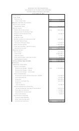
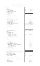
50-54 6,343 3,253 3,090<br />
55-59 4,712 2,296 2,416<br />
60-64 3,551 1,727 1,824<br />
65-69 2,310 1,053 1,257<br />
70-74 1,499 652 847<br />
75-79 785 309 476<br />
80 above 784 295 489<br />
Total 228,949 115,348 113,601<br />
Source: National Statistics Office<br />
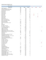
Population Density per Barangay (per hectare)<br />
August 1, 2007 Total Population<br />
Name of Barangay No. of Population<br />
Area Population Density<br />
(per hectare)<br />
(in has)<br />
San Rafael Village 3,662 39 93.90<br />
North Bay Blvd. South 66,566 254 262.07<br />
North Bay Blvd. North 15,970 65 245.69<br />
Bangkulasi 7,437 15 495.80<br />
Bagumbayan South 4,710 5 942<br />
Bagumbayan North 3,388 4 847<br />
<strong>Navotas</strong> West 8,738 7 1,248.28<br />
<strong>Navotas</strong> East 2,299 6 383.17<br />
Sipac-Almacen 11,304 27 418.67<br />
San Jose 27,342 71 385.10<br />
Daanghari 18,932 26 728.15<br />
San Roque 18,062 27 668.96<br />
Tangos 33,211 31 1,071.32<br />
Tanza 23,723 492 48.22<br />
Total 245,344 1,069<br />
a. Demography<br />
• <strong>Navotas</strong>’ August 1, 2007 Total Population = 245,344<br />
• Density per sq. km. = 22,951<br />
• Average households size (2000 Census) = 4.65<br />
• Highly dense barangay = <strong>Navotas</strong> West<br />
• Least dense barangay = Tanza<br />
b. Registered Voters<br />
The table below will show the total number of registered voters in <strong>Navotas</strong> with a reference<br />
date of February 12, <strong>2008</strong>, classified by barangay and sex. The total number of registered voters is<br />
12