Socio Economic Profile 2008 - Navotas City
Socio Economic Profile 2008 - Navotas City
Socio Economic Profile 2008 - Navotas City

Create successful ePaper yourself
Turn your PDF publications into a flip-book with our unique Google optimized e-Paper software.
incremental changes as well as major building projects affect the quality of life of the local community of <strong>Navotas</strong><br />
as well as its peripheral communities.<br />
2. Land Area<br />
The total land area of <strong>Navotas</strong> is 1069 hectares representing 1.69% of the total land area of Metro Manila.<br />
The city is composed of 14 barangays.<br />
3. Existing Land Use<br />
The majority of land in the city of <strong>Navotas</strong> is used as residential and industrial. This is without considering<br />
the enormous area currently occupied by the unused and unproductive fishponds.<br />
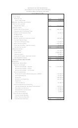
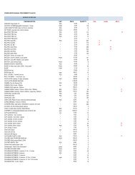
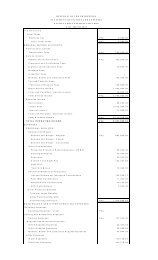
The Land Use of the <strong>City</strong> circa 2002<br />
Land Use Area (has) Total %<br />
Residential 403.23 37.72%<br />
Commercial 22.29 2.09%<br />
Institutional 11.42 1.07%<br />
Industrial 149.60 13.99%<br />
Parks and Open Spaces 6.25 0.58%<br />
Fishponds 476.21 44.55%<br />
Total 1069 100%<br />
Technically, fishponds are the largest land users in <strong>Navotas</strong>. However, these fishponds are not currently in<br />
use and have not been productive for some time now and have been left as water-filled open areas. The fishponds,<br />
concentrated in Barangay Tanza, are located in the northern portion of the city and comprise almost half of the land<br />
area of <strong>Navotas</strong> at 44.55% equivalent to 476.21 hectares. In the past, these areas were productively serving the<br />
locality as an economic base sustaining the livelihood of the locality and providing the metropolis with water-based<br />
resources since <strong>Navotas</strong> is a coastal city and has traditionally in its history functioned as the fishing center of the<br />
metropolis. However, over the time these fishponds slowly lost their intended function mainly perhaps as a result<br />
and effect of the presence of the <strong>Navotas</strong> Fishport Complex. The complex may initially have a positive impact in<br />
sustaining the fishponds but gradually it negatively impacted them due to the large scale trading in fish and seabased<br />
resources that emerged in the continued progress and expansion of the fishport complex. In light of this, it<br />
can be viewed that the largest land use activity in the locality is residential at 37.72% comprising 403.23 hectares<br />
of the town’s 1069 hectares. Residential land use dominates the entire city and is widespread mostly in the central<br />
portion of the elongated profile of <strong>Navotas</strong>.<br />
The second largest land using activity is industrial at 13.99% with 149.60 hectares. This industrial belt is<br />
mostly found in the southern portion surrounding the <strong>Navotas</strong> Fishport Complex and effectively serviced by the<br />
major transport infrastructures like C-3 and North Bay Boulevard. Industrial land using activities seem to thrive in<br />
the locality mainly due to the presence of the fishport complex which influenced the emergence of support<br />
industries and the presence of affordable labor since <strong>Navotas</strong> was mainly a residential city and for a period of its<br />
history a spill area of Malabon.<br />
44