Gambian Buchaneer By Andy Buchan - British Microlight Aircraft ...
Gambian Buchaneer By Andy Buchan - British Microlight Aircraft ...
Gambian Buchaneer By Andy Buchan - British Microlight Aircraft ...

Create successful ePaper yourself
Turn your PDF publications into a flip-book with our unique Google optimized e-Paper software.
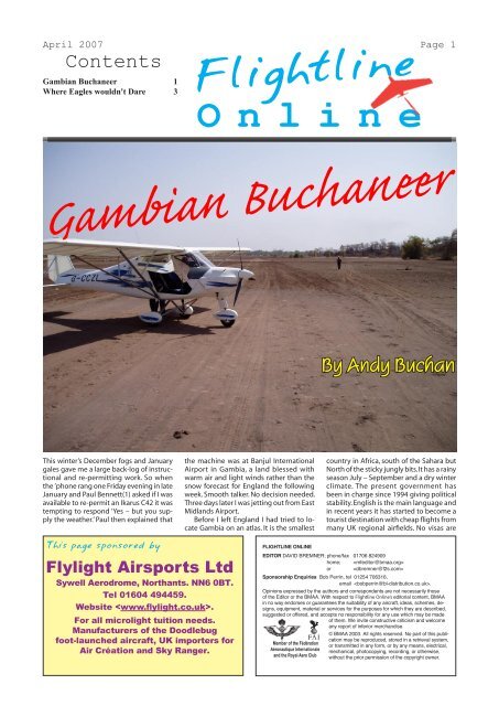
April 2007 Page 1<br />
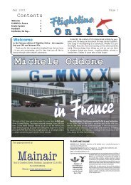
Contents<br />
<strong>Gambian</strong> <strong><strong>Buchan</strong>eer</strong> 1<br />
Where Eagles wouldn't Dare 3<br />
Flightline<br />
O n l i n e<br />
<strong>Gambian</strong> <strong><strong>Buchan</strong>eer</strong><br />
This winter’s December fogs and January<br />
gales gave me a large back-log of instructional<br />
and re-permitting work. So when<br />
the ’phone rang one Friday evening in late<br />
January and Paul Bennett(1) asked if I was<br />
available to re-permit an Ikarus C42 it was<br />
tempting to respond ‘Yes – but you supply<br />
the weather.’ Paul then explained that<br />
This page sponsored by<br />
Flylight Airsports Ltd<br />
Sywell Aerodrome, Northants. NN6 0BT.<br />
Tel 01604 494459.<br />
Website .<br />
For all microlight tuition needs.<br />
Manufacturers of the Doodlebug<br />
foot-launched aircraft, UK importers for<br />
Air Création and Sky Ranger.<br />
the machine was at Banjul International<br />
Airport in Gambia, a land blessed with<br />
warm air and light winds rather than the<br />
snow forecast for England the following<br />
week. Smooth talker. No decision needed.<br />
Three days later I was jetting out from East<br />
Midlands Airport.<br />
Before I left England I had tried to locate<br />
Gambia on an atlas. It is the smallest<br />
FLIGHTLINE ONLINE<br />
EDITOR DAVID BREMNER; phone/fax 01706 824909<br />
home; <br />
or <br />
Sponsorship Enquiries Bob Perrin, tel 01254 706316,<br />
email .<br />
Opinions expressed by the authors and correspondents are not necessarily those<br />
of the Editor or the BMAA. With respect to Flightline Online’s editorial content, BMAA<br />
in no way endorses or guarantees the suitability of any aircraft, ideas, schemes, designs,<br />
equipment, material or services for the purposes for which they are described,<br />
suggested or offered, and accepts no responsibility for any use which may be made<br />
of them. We invite constructive criticism and welcome<br />
any report of inferior merchandise.<br />
Member of the Fédération<br />
Aéronautique Internationale<br />
and the Royal Aero Club<br />
<strong>By</strong> <strong>Andy</strong> <strong>Buchan</strong><br />
country in Africa, south of the Sahara but<br />
North of the sticky jungly bits. It has a rainy<br />
season July – September and a dry winter<br />
climate. The present government has<br />
been in charge since 1994 giving political<br />
stability. English is the main language and<br />
in recent years it has started to become a<br />
tourist destination with cheap flights from<br />
many UK regional airfields. No visas are<br />
© BMAA 2003. All rights reserved. No part of this publication<br />
may be reproduced, stored in a retrieval system,<br />
or transmitted in any form, or by any means, electrical,<br />
mechanical, photocopying, recording, or otherwise,<br />
without the prior permission of the copyright owner.
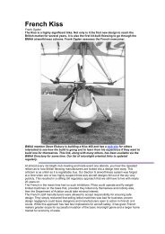
April 2007 Flightline Online Page 2<br />
From the sublime -<br />
3.8km of runway at Banjul<br />
International - all to yourself...<br />
needed for UK citizens so travelling there is as simple (and possibly<br />
more reliable) than taking a bus. The country is developing quickly<br />
and people are friendly – the only time I was ‘hassled’ was when I<br />
dropped the case of my camera in a market and the stall holders<br />
started shouting after me. Six hours after leaving EMA I was met by<br />
my host, Steve Turton, at Banjul. Steve fl ies both 3-axis and fl exwing<br />
microlights and also runs an air courier business in a souped-up<br />
Cessna 172A. Acclimatising to the warm dry weather took all of two<br />
beers, and the next couple of days were spent servicing the C42.<br />
I now know where they hide the<br />
lower grease nipple for the front<br />
forks. Servicing and Inspection<br />
completed, Steve then fl ew with<br />
me for the check fl ight.<br />
I rarely use radio so I was a<br />
little worried about local RT procedures<br />
but by the late afternoon<br />
the airport was very quiet and we<br />
taxied to the mid-point of runway<br />
32. I am usually very careful to use<br />
the full length of a runway but in<br />
this case it seemed acceptable<br />
to use only half of the available<br />
3.8km. The runway had been built<br />
as an emergency landing site for<br />
the space shuttle, so, keeping a<br />
good look out (just in case…) we<br />
departed for the nearby Atlantic<br />
coast to check things out.<br />
The C42 is an amazing bit of kit. At slow speeds (35kts) it just<br />
wallows around without dropping a wing; as speed increases the<br />
controls fi rm up and two up it will cruise happily at 80kts on an<br />
80hp Rotax 912. And all from a simple alloy tube airframe with<br />
fabric wing covering.<br />
Our return to the airport was as straightforward as our departure.<br />
After reporting airfi eld in sight (and with a 3.8km runway<br />
you could make that call quite early), downwind and short fi nals,<br />
we fl oated down the tarmac runway in smooth evening air. Repermitting<br />
work completed!<br />
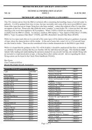
... to the ridiculous.<br />
A bush strip from the air<br />
Over the next few days I fl ew with Steve to several nearby bush<br />
strips. Slightly shorter and more bumpy than Banjul International,<br />
they were also a bit more challenging. And diffi cult to spot. In a<br />
countryside of fl at brown savannah and no detailed maps the GPS<br />
rules OK. But even if it had failed the silver ribbon of the Atlantic<br />
coast to the West and the lush green mango swamps gilding the<br />
River Gambia would have brought us back to Banjul.<br />
Over the last 10 years various <strong>British</strong> instructors have based<br />
themselves in Gambia(2). Today there is just the C42, an enormous<br />
underused runway, a hangar and<br />
schoolroom. What potential! Hopefully<br />
someone will continue to train<br />
at Banjul as the locals are very keen<br />
to see microlights remain there. If<br />
you are a QFI and fancy a warm<br />
winter’s fl ying please contact <strong>Andy</strong><br />
<strong>Buchan</strong> on 01623 883802 or Steve<br />
Turton at for furtherdetails.<br />
(1) Paul Bennett must be one of<br />
the BMAA’s most experienced and<br />
longest fl ying members. Loosely<br />
based in the Midlands, Paul will fl y<br />
and Instruct on just about anything<br />
and has done so for many, many<br />
years. He flew the C42 which I<br />
tested from England to Gambia<br />
in December 2005 where it now<br />
resides with it’s owner, Ian Stokes (rtd) – ex Davidstowe, Thruster<br />
and X’Air guru.<br />
(2) Julian Crofts started Madox Airsports fl ying tourists and<br />
instructing from the beach in 1996 on a Cosmos fl exwing. Ian<br />
Stokes and Will Knowles moved the fl ying to Banjul International<br />
Airport and by 2004 had a fl eet of 2xQuantum 912 trikes, an AX3<br />
and a Thruster. After Will retuned to England in late 2004 the<br />
hangar was empty of <strong>British</strong> microlights until the C42 arrived. The<br />
hangar now holds the C42, 2 x Cessnas and an Ikarus C22 which<br />
is a bit like an AX3.<br />
This page sponsored by<br />
P&M<br />
Aviation<br />
Unit B, Crawford Street, Rochdale,<br />
Lancashire. OL16 5NU.<br />
Tel 01706 655134.<br />
Website .
April 2007 Flightline Online Page 3<br />
Here’s an article published twenty years ago in Flightline, Mar-Apr 1987.<br />
Author David Young and chief pilot Simon Baker are still microlight instructors,<br />
of course, and this first trip up Mount Everest makes for interesting comparisons<br />
with Richard Meredith-Hardy’s overflight seventeen years later.<br />
Where Eagles wouldn't Dare<br />
The buffeting increased and there were birds<br />
of prey ahead of us. Suddenly, caught in the same<br />
thermal, we were with them; 12 enormous eagles!<br />
Awed by their splendour, we sailed on our course<br />
and they kept on theirs, slowly circling in the warm<br />
rising air. We had permission to fly at 1000 ft agl,<br />
and sometimes as we looked straight down there<br />
would be indeed be 1000 ft of space below us,<br />
but at other times we would skip just 100 ft over<br />
a mountain ridge.<br />
Automatically I worked away at the normal<br />
flight checks — time elapsed into flight and fuel<br />
level. I listened to the beat of my 440 Robin. It<br />
was thrumming away perfectly and the twin CHT<br />
readings were both constant. I looked for possible<br />
landing sites — odd patches of terracing and the<br />
odd sandbank down on a river bend.<br />
After 70 miles we found the confluence of the<br />
Sun Kosi and the Dudh Kosi. Where the waters<br />
met the river swelled to a mighty flow, carving<br />
further east and out to the Indian plain. Turning<br />
In the Kathmandu valley, a green sea of space<br />
surrounded by mountains, the tyres of a Boeing<br />
707 screech on contact with the tarmac at Nepal’s<br />
international airport.<br />
The pungence of burnt jet fuel reaches the<br />
nostrils of two young flying instructors. Both are<br />
beginning to sweat in their flying suits as they<br />
wait for radio clearance from the control tower<br />
to move out behind the 707’s wake.<br />
At 10.15 am two tiny bright red microlights<br />
taxi forward onto the main runway opposite the<br />
airport complex. It’s 16 September 1986. The<br />
instructors piloting the craft glance at each other.<br />
away from this spectacular landmark we headed<br />
north-east up the course of the river that emanates<br />
from Everest.<br />
We skirted storm<br />
cloud and saw a rainbow,<br />
first flying in shadow then<br />
bursting into light. After 2<br />
h we found our first landing<br />
site, at Lamidanda, an<br />
airstrip on top of a 3500ft<br />
mountain.<br />
With the noise of our<br />
arrival, Nepalese came<br />
scurrying from all directions<br />
to see us. On the<br />
ground we made contact<br />
with our team of porters<br />
with whom we would, in<br />
the coming weeks, form<br />
an association of friendship<br />
and respect — us for<br />
The usual airport hubbub and noise seems to disappear.<br />
At this moment everything is transfixed.<br />
All eyes are on the aircraft, side by side on the<br />
runway. Simon Baker, a 32 year-old Australian,<br />
nods to David Young, 33; there is a burst of noise<br />
and the two aircraft surge forward, take off in<br />
formation and disappear towards the hills.<br />
Daring young men in flying machines are making<br />
history again. These, the first microlights to fly<br />
in Nepal, are being piloted into the magnificent and<br />
notoriously treacherous Himalayas. They will fly<br />
close to Mount Everest and break challenging new<br />
ground in microlight aviation. They, and the team<br />
of which they are a part, are trying to shoot kayaks<br />
down the white waters of the world’s highest river,<br />
the Dudh Kosi, using microlights to provide aerial<br />
support, reconnaissance of the rapids, film work,<br />
and ferrying of supplies.<br />
As the airport and the Kathmandu valley<br />
receded behind us, the truly awesome reality of<br />
what we were doing started to sink in. The valley<br />
gave way to spectacular mountain ridges, largely<br />
cultivated in terraces. A telegraph line followed the<br />
road below, making even that impossible to land<br />
on in an emergency. Already cumulus cloud was<br />
building to the north, hiding from us the view of<br />
the snow-capped highest peaks in the world. The<br />
road, the Arniko Highway, also disappeared in<br />
that direction, towards the Tibetan border which<br />
was just 40 miles away at this point. Our course<br />
followed the ridge to Kottimal, 6700ft.<br />
Well, it looked like a ridge on our tourist map!<br />
In this mountainscape we were nothing. The<br />
ground unfolded this way and that and it was all<br />
too easy to get confused. I stuck to my easterly<br />
heading, searching for the Sun Kosi river valley<br />
and thankful that Simon was ahead of me on the<br />
same course. The cloud thickened and threatened;<br />
we sped along at 60mph just underneath it, suffering<br />
the jolts of the moving air masses. Mercifully it<br />
cleared again, so the way ahead was open.<br />
With the rendezvous with the river there was<br />
relief and then pangs of uncertainty as I tried to reconcile<br />
what I was seeing with the limited amount<br />
of detail on the map. After some consternation I<br />
found that by looking ahead some 12 miles I could<br />
make out distinctly where the Tamba Kosi joined<br />
our own west-east route. There is a rather isolated<br />
bulk of 5000ft mountain on the east side of the<br />
confluence, and this now became our target.
April 2007 Flightline Online Page 4<br />
This page sponsored by<br />
Flylight Airsports Ltd<br />
Sywell Aerodrome, Northants. NN6 0BT.<br />
Tel 01604 494459.<br />
Website .<br />
For all microlight tuition needs.<br />
Manufacturers of the Doodlebug<br />
foot-launched aircraft, UK importers for<br />
Air Création and Sky Ranger.<br />
their skills and they for ours. But for now, all we<br />
felt was an indescribable elation as we sipped hot<br />
tea by our tent and admired the view.<br />
Our epic journey was to be tackled in stages.<br />
Like mountaineers, we were to stop (at tiny airstrips)<br />
and camp, then move up higher. We had the<br />
advantage of speed and would be able to snatch<br />
the opportunity hi good weather to dash to our<br />
next camp. Even so, there was the ever present<br />
fear that cloud would form with the anabatic wind<br />
and cover our retreat. If our higher destination was<br />
also in cloud we would be rather embarrassed. We<br />
would also have to be careful not to jump too high<br />
too quickly. Altitude sickness can be fatal. Above<br />
13,000 ft, climbers should only advance at 1000ft<br />
per day in order to acclimatise to the thin air.<br />
As we ate our simple meal that afternoon in<br />
front of our tent we found ourselves spending half<br />
the time revelling in the wonder of where we were<br />
and the other half studying the fast-changing cloud<br />
— watching it build and decay, and swirl this way<br />
and that. Then we began a new pattern of life, going<br />
to bed at dusk and rising with the sun.<br />
After all the preparation in England and the<br />
last three weeks in Kathmandu it was splendid to<br />
at last be out here in the mountains. Alas, even at<br />
this early stage there was something wrong.<br />
Simon was flying a Series II Raven which had<br />
been re-engined for the trip with a 600cc 75hp<br />
three-cylinder Robin, to give him the extra thrust<br />
needed to carry cameraman and equipment at high<br />
altitude. The engine had been running properly<br />
but Simon had discovered a small fracture in the<br />
exhaust pipe. It was a problem that was to dog us<br />
for the rest of our journey.<br />
In his usual quiet way Simon, veteran of the<br />
1983 Iceland Breakthrough Expedition, considered<br />
the situation. We were faced with a 90 mile flight if<br />
we retraced our route to Kathmandu — and neither<br />
of us fancied taking that seemingly retrograde step.<br />
There was another option. We knew of the <strong>British</strong><br />
Gurkha army camp at Dharan Bazar, which was<br />
only 55 miles away, just out of the mountains on<br />
the northern edge of the Indian plain. What the<br />
army camp was like and whether it contained the<br />
welding equipment we needed we had no idea, but,<br />
at least if we flew there in my 440-engined machine<br />
it would give us the opportunity to reconnoitre<br />
the lower sections of the Sun Kosi over which we<br />
would be flying towards the end of the trip.<br />
Having removed his cracked silencer, Simon<br />
now discovered a crack in the engine mounting<br />
plate. We both take things fairly philosophically!<br />
Supporting the engine by a rope from the trike<br />
pylon we started stripping things down only to<br />
realise that as the mounting plate is aluminium it<br />
cannot easily be welded. We retire to our camp for<br />
tea. The sun bursts out of cloud and the temperature<br />
soars. One certainly couldn’t wish to be stranded<br />
in a more beautiful place. Just once this morning<br />
we had a glimpse through the cloud of the high<br />
snow-covered peaks near<br />
Everest.<br />
The man at Lamidanda<br />
Airport seemed<br />
over- enthusiastic about<br />
his work and Simon very<br />
nearly got upset. The<br />
man couldn’t seem to get<br />
it into his head that we<br />
could actually fly without<br />
radio. All we wanted was<br />
to make a VFR flight to<br />
Dharan Bazar, departing<br />
at 12.45 pm local time<br />
and with no return ETA.<br />
Because this flight was<br />
not in the original plan of<br />
our expedition, the chap<br />
was clearly not happy. Luckily the army camp was<br />
just inside the latitudes and longitudes specified for<br />
our operation by the Nepal CANs Notam.<br />
So we left. Underneath the craft the silencer<br />
was securely tied along with a rucksack containing<br />
flares, medical kit, water, basic tools and<br />
toilet paper. The essential fuel filter funnel was<br />
also tied in place. The engine mounting plate was<br />
tucked between Simon and myself when we were<br />
seated. I called on radio for taxi clearance as Simon<br />
manoeuvred into position. There is an uphill<br />
gradient as you face to take-off to the south-west.<br />
We could see about 50 yards ahead to where the<br />
hill rounded out.<br />
We built up speed as the special suspension<br />
absorbed the shocks. Just before the longer grass<br />
at the end of the runway, the aircraft skipped into<br />
the air as a little gust of wind gave us airspeed. But<br />
then we were down again, the grass tearing at the<br />
rear-wheel axle wires. However, we couldn’t stop<br />
now — 20 yards ahead was the precipice. With ten<br />
yards to go she wallowed into the air, struggling<br />
over terraced gardens. Then there was clear air for<br />
1000ft. I radioed that we were clear of runway but<br />
it was obvious that the tower couldn’t hear me.<br />
And when Simon shouted into the intercom, ‘Look<br />
at the airfield’, I realised why. Turning around, I<br />
saw that the airfield was now actually higher than<br />
our aircraft!<br />
The level of humidity had caught us out and<br />
we were unable to climb. Two minutes into flight,<br />
instead of being able to make a 90° left turn and<br />
fly over a ridge and down to the Sun Kosi on a<br />
simple SE heading out of the mountains, we were<br />
forced by the valley sides to fly ahead to the south<br />
west. Simon kept to the eastern side of the valley,<br />
trying to find some lift. Our second opportunity to<br />
cross the ridge came and went. We had arced to<br />
within 100ft of the top in both height and distance.<br />
‘Bottled out’, Simon called, ‘Too much sink the<br />
other side.’ There was no desperate problem about<br />
following the river course except that it made our<br />
journey so much longer — another 30 miles. We<br />
pushed on along our enforced track until after an<br />
hour’s flying we had another opportunity for a<br />
short cut, at Suntale.<br />
We turned east up a valley. The cloud was low<br />
but through the gap at the head of the valley we<br />
could just make out the lowlands far ahead. As we<br />
approached the bowl leading to this ‘nick’ in the<br />
Rapcha Range we were skimming under cloudbase.<br />
Simon descended toward the lowest point<br />
on the ridge — the view glimpsed a moment ago<br />
had gone. I kept putting off a decision, then Simon<br />
gave a thumbs up and he got an encouraging pat on<br />
the shoulder from me. There’s no time to discuss<br />
things here; you have to have total confidence in<br />
your team-mate. Besides, Simon was in the front<br />
seat and I couldn’t get to the bar!<br />
Suddenly children rushed from a school right<br />
on the ridge. We were actually level with the school<br />
and ahead there was only cloud. We flashed past<br />
the children barely 100ft from the ground. Over<br />
the gap, trees flashing past and down — 2000fpm<br />
on the VSI — we shot down a tree-lined gorge,<br />
just keeping our 100-150 ft clearance until, like<br />
magic, we cleared the bottom of the cloud and had<br />
the most wonderful view of the plain, way ahead.<br />
Jumping the last range of hills to the open country<br />
was not the shortest way to Dharan but we had had<br />
enough of mountains for the moment!<br />
It was hot. We descended slowly in the stifling<br />
humid air until we were 1000ft over the jungle.<br />
Chatra, our expedition’s finishing point, came up<br />
and then we looked anxiously ahead for the army<br />
camp. A group of thatched huts and a <strong>British</strong> officer<br />
in a tent? Thankfully no. The Gurkha camp<br />
is markedly different from the surroundings. Neat<br />
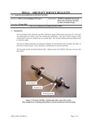
<strong>Microlight</strong> pilots Simon Baker (left) and<br />
David Young.<br />
Brilliant sun one minute, thick cloud the next — the<br />
weather can really play tricks in the Himalayas.
April 2007 Flightline Online Page 5<br />
barrack blocks, workshops, a hospital, houses for senior men, even tennis<br />
courts. Finding the landing strip was none too difficult either; the landing T<br />
was clearly to be seen at the end of number 3 fairway on the golf course.<br />
We landed and stopped by an amazed officer’s wife, Mrs Say, and a totally<br />
shocked and stunned Nepalese caddy. The hospitality of Lt Col Mike Kefford<br />
was exceptional. An experienced mountaineer, he was more than sympathetic<br />
to our plight and in no time the exhaust repair and the manufacture of a replacement<br />
engine-mounting plate, in steel this time, was under way.<br />
Stuck here for two days, we made the most of this little haven of Western<br />
convenience in the Third World. We showered, had our hair cut, saw a film,<br />
gave a little talk to the <strong>British</strong> school children about our expedition, organised<br />
a supply of fuel and oil and took a couple of people for flights.<br />
On Friday 19 September at 7 am we took off again, hoping to climb back<br />
to the mountains while the air was still cool. A great long line of Nepalese<br />
children gathered along the perimeter fence to watch us as we accelerated<br />
down the smooth-cut grass and climbed over the tall slender trees of the surrounding<br />
forest into a perfectly calm morning sky.<br />
The journey back to Lamidanda was a piece of cake. First, we climbed<br />
to 2000ft over the Sun Kosi valley. It was magnificent to look up and down<br />
the river course filled with cloud, bright and crisp and pink to our right into<br />
sun, a little duller to the left where it merged with distant mists and shapes of<br />
hills. Then past 4000ft. and it’s a little frightening looking down at the chasms<br />
carved by smaller streams in sharply descending rock. At the halfway point<br />
cumulus cloud is building all around the hills ahead, while above us the strato<br />
cumulus is getting thicker. Could we end up in a cloud sandwich? We push<br />
on, each immersed in our own thoughts.<br />
And then at Paharpani, at 7000ft, something magical happened. A horizontal<br />
cleft of blue sky to the north sneaked into our perception. A dreamed-of<br />
panorama lay across the sky — the magnificent Himalayas. Simon whooped,<br />
his eyes sparkled in the light, and a big smile spread across his face. In our<br />
first view of the highest mountains in the world, all fears were swept aside<br />
— there was no room in our thoughts for anything other than joy at such a<br />
magnificent spectacle. A little while later, looking down through holes in the<br />
cloud, we found Lamidanda and lazily descended through the gap.<br />
After the completion of repairs we departed for Lulda airstrip, 9000 ft up.<br />
I had to tuck a bicycle pump down the leg of my flying suit as it had been left<br />
out of my main pack and I’m still amused by the sight of Simon’s umbrella,<br />
tied underneath the trike base-tube.<br />
We worked our way up the Dudh Kosi valley with 20,000ft peaks towering<br />
around us — this time the journey was really taking us into the mountains.<br />
The 440 Robin buzzed away merrily — on full power all the time. Little did<br />
I know how thankful I was going to be next time I saw this airfield following<br />
an engine seizure at 13,000ft nine miles away! Simon and I both had<br />
standard microlight altimeters which only read up to 8000 ft — slight lack<br />
of technical planning there! I guessed my height from the map, assessing<br />
my position relative to various peaks. Simon had a reserve altimeter which<br />
went to 18,000 ft.<br />
From now on the special wing developed by Roy Venton-Walters of<br />
Southdown International would be put to the test, as would the suspension<br />
fitted to both trike units. The Series II Raven was specifically developed for<br />
Nepal with the idea that it might also make a good training wing. With a fatter<br />
aerofoil section than the standard Raven, it had a lower stall speed, and<br />
thus a better short take-off and landing performance. Area and camber had<br />
also been increased. Southdown had produced these two special wings in just<br />
seven months, once again in red and gold, the colours that Gerry Breen chose<br />
for the Iceland expedition.<br />
Lulda airstrip is 700 yards long with a height difference of 60m between<br />
one end of the runway and the other. You approach over a 1500ft ravine and<br />
land uphill (and downwind) towards a mountain. I ignored my instruments<br />
and flew by feel, approaching with excess speed to ensure plenty of energy<br />
This page sponsored by<br />
P&M<br />
Aviation<br />
Unit B, Crawford Street, Rochdale,<br />
Lancashire. OL16 5NU.<br />
Tel 01706 655134.<br />
Website .<br />
for the uphill roundout.<br />
We compared notes about this 1hr flight, our first above 14,000ft. Already<br />
we had flown among the most magnificent mountains, seen Everest, and<br />
landed at 9000 ft — we were elated. The villagers flocked to see us and our<br />
machines.<br />
Now it was time to meet the canoeing team, who had endured a 24 h<br />
bus ride and an eight-day walk to get to this same place. The team had been<br />
cheered at seeing the microlights fly over them the previous day as there had<br />
been no communication for over a week. They had all been bitten by leeches<br />
and film camerman Nick Downie said that the walking was beginning to<br />
‘get a bit boring!’ Simon and I had some fun exaggerating tales of life at the<br />
Dharan Bazar Camp and asked for next Friday off so that we could go to the<br />
nurses’ ball. It was all taken in good spirit.<br />
With all the team together, work really started. Canoeists went off to examine<br />
stretches of the river in the ravine. Simon had to go back to Dharan on<br />
my machine for a more substantial exhaust repair. Then the big three-cylinder<br />
trike was used to transport a team member to Syangboche. Micky Gordon had<br />
a broken leg and flying him to Syangboche saved him an agonising two-day<br />
walk — the flight took just 20 min!<br />
There were minor repairs necessary and preparations to make, like fitting<br />
camera mounts on the aircraft. We undertook parachute training and then<br />
decided to do without them, to avoid the extra weight.<br />
When you turn out from the holding point at Lukla and face down the<br />
runway, for a microlight without brakes there’s no going back. You roll down<br />
the hill, quickly gathering speed and start agonising about whether you did<br />
all your checks properly. I was away, but with only 200fpm on the VSI.<br />
With the wing-mounted camera and counterbalance, the aircraft seemed to<br />
be tip- stalling only a nudge forward of trim. I still wasn’t happy with the<br />
ASI, so I ignored it.<br />
Below the Dudh Kosi swept quickly out of the mountains. I thought of<br />
the canoeists: rather them than me. A little cloud floated alongside me on<br />
the west side of the valley. Ahead Namche was caught in a pool of sunlight.<br />
Again the time passed slowly.<br />
<strong>By</strong> the time Simon was circling the airstrip at Syangboche, I was level<br />
with the airfield but still three miles south. I kept a constant watch on the CHT<br />
— it showed 290° F, good. Frantically I took some photos of the views, but<br />
the overriding concern was flight. Level with the airfield just wasn’t good<br />
enough to make a landing. I cut left across Namche itself, where there is a<br />
bowl above the town, and I joined the crows, soaring.<br />
As I worked my way higher I realised the valley wind was probably increasing,<br />
so I lined up and sped in. A downwind landing, at 12,000 ft. on a 400 yard<br />
airstrip ending in a hill — and no brakes! What more could you ask for?<br />
The mountains were bathed in sunshine, but below cloud was billowing<br />
up towards us. It was 8.25 am. Ten minutes after I landed the mountains<br />
had disappeared, we were completely enveloped in cloud and the wind had<br />
picked up.<br />
On a better day there was some excitement when Simon made a two-up<br />
take-off from here with Mary Ganczakowski, the expedition doctor, and in<br />
the process set a new record. Meantime an advance party of canoeists had<br />
gone ahead to clear a runway at Pheriche. This was literally to be a landing<br />
on a mountainside, at 14,600 ft.<br />
It was Monday 29 September, 9 am. Simon took off from Syangboche,<br />
dropped a wing, expertly recovered and was away. We couldn’t win here,<br />
for this time it was a downwind take-off. As I started down the slope two<br />
yaks appeared trotting towards the runway. Our porters shouted at them and<br />
I reckoned on getting through. With 30 yards to go before the yaks my visor<br />
misted up. Pushing the bar right forward, the aircraft leapt into the air and<br />
promptly stalled, almost recovered but bounced before getting away; I managed<br />
to catch a dropping wing and headed out over the valley.<br />
Now it was time to fly over the famous Thyangboche monastery where on<br />
the recce Simon and expedition organiser Mick Coyne had obtained permission<br />
from the Lama to land. It was a struggle to get to 14,000ft and I had to<br />
scratch around the hills to get another 1000ft for the landing on the mountain.<br />
Simon was down first, inaugurating a strip where canoeists and porters had<br />
been working for three days clearing rocks. We made it!<br />
This spot was the stuff of dreams. We called it Camp Raven. The classic<br />
spectacular mountain Ama Dablam towered above us, its peak at over<br />
22,000ft, and the view back down the valley was such that we really felt on<br />
top of the world.<br />
Mick Coyne was there to meet us, face like a lobster from too much sun<br />
above the snowline, where he had been already to organise the high- altitude<br />
strip at 17,000ft at Gorak Shep, just a mile from Everest base camp.<br />
I was feeling a little peculiar and needed a day and some pills from the<br />
doctor to acclimatise. That night we had a celebration dinner. It was top paddler<br />
Mike Hewlett’s birthday and the microlights had been making history every<br />
step of the way. As Simon said: ‘It was magic — and we thought we might not<br />
get any higher.’ A porter was despatched to find a lamb for slaughter. This was<br />
duly walked into town and brought on a lead right up to the cooking pot.
April 2007 Flightline Online Page 6<br />
Simon’s exhaust was cracked again, necessitating an epic trip to Dharan<br />
flying across almost the entire width of Nepal, from 14,600ft down to near<br />
sea level, a 2h flight and a distance over 100 miles. The exhaust was repaired<br />
immediately and only 1 h later he was back over Lamidanda. There was<br />
threatening cloud all around, so ‘I decided to spiral down through a small gap,<br />
descending 5000ft’, he explained. ‘It blew my ears out — I was deaf for two<br />
days.’ He managed to get back to Camp Raven the following day.<br />
We did some flying for film, and then later in the day Simon made a<br />
downwind landing very fast and just stopped before rocks. Without his<br />
special front brake and suspension we would have had a damaged aircraft,<br />
but as it was, all we had was a broken exhaust — again! This time it was my<br />
turn for the flight out.<br />
The engine seizure that occured at 13,000ft was the worst moment for me<br />
on the trip. Syangboche was tantalisingly close but I opted to go for Lukla,<br />
working the mountain ridges for scraps of lift for 9 miles, with nothing below<br />
but the ravine. Rocks, trees, and fast-rushing river, but nowhere to land.<br />
Landing at Lukla had one big plus, in that our spare 440 engine was there.<br />
I worked on the aircraft for two days before I was prepared to fly again. In<br />
the meantime I got the exhaust on a helicopter to Kathmandu. Back I went<br />
to Pheriche.<br />
Simon and I walked up to Gorak Shep, just seven miles from the summit<br />
of Mount Everest, and examined the landing strip there on a dried-up lake bed.<br />
The canoeists and porters had again done a great job. The original intention<br />
had been for Simon and I to each attempt a landing here, with Simon taking<br />
off again but the smaller- engined machine being de-rigged and carried out.<br />
Alas, the exhaust had fractured yet again and there was pressure on us now to<br />
complete this phase of the operation and start following the canoes down the<br />
river. So I stepped down so that Simon, the chief pilot, could fly the 440.<br />
On 13 October 1986 Simon flew a standard 440 Fuji Robin trike with<br />
a Series II Raven wing to over 20,000ft. He had to get good height, for<br />
the glacier was ‘a disgusting looking place’. Great hulks of ice, massive<br />
crevasses, and moraine strewn untidily everywhere. He descended near the<br />
south col, over Everest base camp, and landed perfectly. Touchdown speed<br />
was around 80 mph.<br />
Shortly after this amazing achievement Simon was left to assist the expedition<br />
on his own. I found myself caught in a freak wind and crashed into<br />
a mountainside at 14,000ft, a 70 mph impact that left me lying in the wreck<br />
with severe internal injuries.<br />
Two American doctors from a mountain rescue centre got to the scene<br />
within 1½h; they nursed me for another 22h before a helicopter was able to<br />
ferry me to Kathmandu for emergency surgery.<br />
I was in pain, but it was not the scene you imagine. The snow line was<br />
much higher and it was actually quite warm. I couldn’t move and I felt in<br />
distress a couple of times before the doctors arrived, but after that it was really<br />
a peaceful experience — there was absolutely nothing I could do, so I<br />
relinquished myself to fate.<br />
Bottling up feelings of having let the team down, and frustration at not<br />
having done the high-altitude photography I wanted, spurred me on to what<br />
I’m told was an amazing recovery. I walked out of hospital eight days later.<br />
I wanted to rejoin the team, but I found it impossible to endure the bumpy<br />
ride in a rickshaw, let alone anything else. My intestines had been split in two<br />
places where the safety belt had snapped into my gut and there was a lot of<br />
internal bruising. The body just doesn’t get over that very quickly.<br />
Back in the wilds the canoeists were making good progress down the<br />
horrendous white water of the world’s highest river and Simon had managed<br />
to get his machine operational again. Telex messages flashed round<br />
the world and suddenly Malcolm McBride from Aerotech was on his way<br />
to take over the second pilot’s role. Malcolm’s engineering skills were put<br />
to the test immediately when he made a forge in a Nepalese hut to heat and<br />
release engine pulleys.<br />
Mingled in with all that were lots of problems. Flying was cancelled<br />
because of the accident and new permission had to be sought to resume. The<br />
leading team of canoeists, tackling some of the most dangerous water, were<br />
five days overdue for a rendezvous, causing great concern, and when they<br />
did appear they were hungry and exhausted. But the microlights were able<br />
to help, taking in a supply of food from the army camp and landing on sand<br />
banks at the side of the river.<br />
Believe it or not, this long article is just an extract from my notes. Perhaps<br />
we can combine the full story with some of the unique colour photos<br />
to make a book. Personally I would like to remember Paul Vander-Molen;<br />
his efforts brought the Iceland Breakthrough team together, when kites and<br />
kyaks worked together for the first time, and led on to this and other expeditions.<br />
His spirit lives on in the people lucky enough to pursue such challenge<br />
and adventure.<br />
Copyright David Young, CFI Pegasus Flight Training, Kemble 1987.