
Create successful ePaper yourself
Turn your PDF publications into a flip-book with our unique Google optimized e-Paper software.
<strong>Sam</strong> <strong>Houston</strong> <strong>Parkway</strong>/<strong>Tollway</strong>, <strong>Beltway</strong> 8<br />
Even before the alignment of Loop 610 had been finalized, the city of <strong>Houston</strong> was<br />
formulating plans for a second loop. It was a remarkable act of vision and foresight to recognize<br />
the future importance of loop highways in today’s predominant suburb-to-suburb<br />
transportation patterns. However, the first wave of freeway construction in <strong>Houston</strong> from<br />
the 1950s to the 1970s came and went with very little progress on the <strong>Beltway</strong>.<br />
The age of the <strong>Houston</strong> <strong>Beltway</strong> arrived with the second wave of <strong>Houston</strong> freeway construction,<br />
which started in the 1980s. By 1996 the entire loop had been constructed in some<br />
form—freeway, tollway, or frontage road. Completion of the South Belt main lanes in 1997<br />
left only one segment without main lanes. The phenomenal success of the <strong>Sam</strong> <strong>Houston</strong><br />
<strong>Tollway</strong>, the toll main lanes of <strong>Beltway</strong> 8, even brought traffic congestion to the western<br />
and northern sections of the tollway.<br />
Although the main lanes of <strong>Beltway</strong> 8 are, for the most part, not very interesting, the<br />
<strong>Beltway</strong> has one of the nation’s most impressive collections of modern four- and five-level<br />
freeway-to-freeway stack interchanges. The <strong>Beltway</strong> is also unusual in that its tollway sections<br />
have continuous toll-free frontage roads.<br />
Origins<br />
<strong>Beltway</strong> 8 had its origins in a 1952 report by the City<br />
of <strong>Houston</strong> Planning Department, Proposed Location for<br />
An Outer Belt Drive for Metropolitan <strong>Houston</strong>. The report<br />
was prepared as a basis for fixing a location for a minimum<br />
120-foot-wide (37 m) thoroughfare located four to<br />
five miles (6 to 8 km) beyond the city limits, which were<br />
generally located near Loop 610 at the time. The 1952 annual<br />
report of the City of <strong>Houston</strong> Planning Commission<br />
went on to explain, “This report was prepared in view of<br />
the imminent development of much of the area through<br />
which the thoroughfare would need to pass and because<br />
there will be a great need for such a thoroughfare in the<br />
future as the population of the urban area spreads.” At<br />
the time the report did not envision the Outer Belt as a<br />
freeway. Ralph Ellifrit, city of <strong>Houston</strong> planning director,<br />
was the individual most responsible for the birth of the<br />
Outer Belt.<br />
In September 1954, based on the recommendation of<br />
Ellifrit, the corridor width was increased to 150 feet (46 m)<br />
to accommodate a larger arterial highway. Also in 1954,<br />
the City of <strong>Houston</strong> Planning Department performed detailed<br />
studies to fix the location of the Outer Belt. Nearly<br />
all of the alignment defined in that period would become<br />
the ultimate route of today’s <strong>Beltway</strong> 8. 29<br />
In 1960 Harris County stepped forward and took the<br />
leading role in the development of the Outer Belt. Harris<br />
County Judge Roy Hofheinz appeared before the <strong>Houston</strong><br />
Planning Commission in March to discuss the merits of<br />
changing the Outer Belt to a full freeway on a minimum<br />
300-foot-wide (91 m) right-of-way. On July 11, 1960,<br />
<strong>Beltway</strong> 8 (<strong>Sam</strong> <strong>Houston</strong> <strong>Parkway</strong>/<strong>Tollway</strong>)<br />
Designated as freeway 1960<br />
First freeway section open<br />
1970 (overpasses only)<br />
1982 (toll bridge)<br />
Freeway/tollway complete Scheduled 2007<br />
Reconstruction<br />
Max traffic volume, 2001<br />
Future construction<br />
Intermittent pavement<br />
repair only<br />
233,000 vehicles per day<br />
Main toll lanes of<br />
northeast segment;<br />
expansion of west and<br />
north tollways<br />
Harris County Commissioner’s Court voted to increase<br />
the corridor right-of-way width to 300 feet and grant it full<br />
freeway status. Harris County would now be in charge of<br />
building the 87-mile (139 km) freeway loop. Getting into<br />
the freeway-building business was a big undertaking for<br />
Harris County and would ultimately be more than it could<br />
manage on its own. As of April 1960, a 300-foot-wide<br />
right-of-way corridor had been obtained for only 8 miles<br />
(13 km). Seven miles (11 km) had 150–250 feet (46–76<br />
m) set aside, and 15 miles (24 km) had 120 feet (36 m)<br />
or less set aside. For the remaining 57 miles (91 km), no<br />
right-of-way had been acquired. However, only 1 mile<br />
(1.6 km) was listed as passing through a built-up area with<br />
“damage to buildings.” The projected cost of the <strong>Beltway</strong><br />
was $150 million, still a relatively low cost after adjusting<br />
to 750 million in 2003 dollars. 30<br />
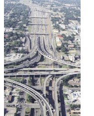
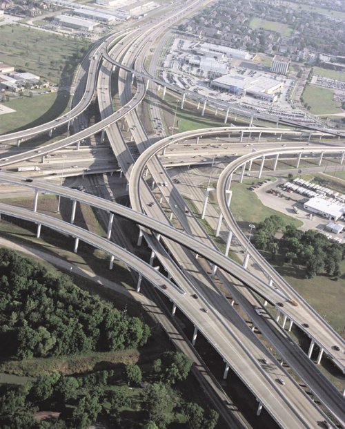
(Opposite page) The Southwest Freeway interchange: <strong>Beltway</strong> 8 gently curves through the interchange, completed<br />
in 1997. The <strong>Beltway</strong> 8/<strong>Sam</strong> <strong>Houston</strong> <strong>Tollway</strong> has an impressive collection of modern, multilevel stack interchanges.<br />
(Photo: May 2003)
296 <strong>Houston</strong> Freeways<br />
<br />
<br />
<br />
<br />
<br />
<br />
<br />
<br />
<br />
<br />
<br />
<br />
<br />
<br />
<br />
<br />
<br />
<br />
<br />
<br />
<br />
<br />
<br />
<br />
<br />
<br />
<br />
<br />
<br />
<br />
<br />
<br />
<br />
<br />
<br />
<br />
<br />
<br />
<br />
<br />
<br />
<br />
<br />
<br />
<br />
<br />
<br />
<br />
<br />
<br />
<br />
<br />
<br />
<br />
<br />
<br />
<br />
<br />
<br />
<br />
<br />
<br />
<br />
<br />
<br />
<br />
<br />
<br />
<br />
<br />
<br />
<br />
<br />
<br />
<br />
<br />
<br />
<br />
<br />
<br />
<br />
<br />
<br />
<br />
<br />
<br />
<br />
<br />
<br />
<br />
<br />
<br />
<br />
<br />
<br />
<br />
<br />
<br />
<br />
An Early Patchwork<br />
Starting in the 1950s, the city of <strong>Houston</strong> and Harris<br />
County began to acquire right-of-way and build short<br />
sections of roadway on the Outer Belt alignment as real<br />
estate developers donated land and as funding permitted.<br />
In 1958, one of the early sections to open was a 2.5-mile<br />
(4 km) section of the East <strong>Beltway</strong> built as a two-lane<br />
roadway north of today’s Business Route 90 (Beaumont<br />
Highway). That section was made possible by a land donation<br />
from a real estate developer and was constructed<br />
to provide access to the development. By the late 1960s,<br />
short sections of frontage roads, or in some cases only one<br />
side of the frontage roads, were open in southeast <strong>Houston</strong><br />
near the Gulf Freeway and in west <strong>Houston</strong> south of<br />
the Katy Freeway. Harris County constructed a section of<br />
frontage roads in Pasadena in 1971. These short sections<br />
were generally not very useful even to local traffic because<br />
of their short lengths and lack of connectivity. 31<br />
One trouble spot for the Outer Belt was already developing<br />
in 1961. The western Outer Belt was aligned to go<br />
through the center of the municipality of Jersey Village<br />
northwest of <strong>Houston</strong>. Jersey Village was just outside<br />
the extra-territorial jurisdiction of the <strong>Houston</strong> Planning<br />
Commission, so the commission had no power to approve<br />
or reject development plans and could not protect the freeway<br />
right-of-way from development. <strong>Houston</strong> Planning<br />
Director Ralph Ellifrit raised an alarm to TxDOT that the<br />
freeway right-of-way was at risk of being developed. The<br />
right-of-way was not protected, and plans for residential<br />
development in Jersey Village proceeded in the path of the<br />
proposed Outer Belt. 32<br />
The only rumbling of community opposition in the
The Loops 297<br />
Controversy: <strong>Beltway</strong> 8 West through the Memorial Bend subdivision<br />
was one of the two controversial sections of the <strong>Beltway</strong>. In 1962<br />
residents of Memorial Bend attempted to have the <strong>Beltway</strong> realigned<br />
three miles west to follow the present-day Dairy Ashford Road, but<br />
the increased cost of the longer alignment resulted in its rejection<br />
by the <strong>Houston</strong> Planning Commission on June 19, 1962. The map<br />
at left, from the original Outer Belt location studies conducted circa<br />
1954, shows the approximate alignment (in red) that was requested<br />
by Memorial Bend residents. As part of the preparation of the environmental<br />
impact statement for<br />
the West Belt in 1975, a study to<br />
determine the feasibility of alternative<br />
routes was completed. The<br />
only possible alternative route for<br />
the West Belt was determined to<br />
be SH 6, six miles to the west. The<br />
SH 6 route was infeasible due to<br />
cost and other impacts. This section<br />
of the <strong>Beltway</strong>, which opened<br />
in 1988, has a highly unusual short<br />
section of a two-way frontage<br />
road, visible on the right side of<br />
the photo. (Photo: May 2002; map,<br />
city of <strong>Houston</strong> records)
298 <strong>Houston</strong> Freeways<br />
early development of the Outer Belt occurred in 1962<br />
when residents of the Memorial Bend subdivision in west<br />
<strong>Houston</strong> objected to plans to align the Outer Belt through<br />
their neighborhood. The neighborhood requested a realignment<br />
of the freeway at a meeting of the City Planning<br />
Commission on June 5, 1962. The proposed realignment<br />
would have shifted the Outer Belt three miles (5 km) west<br />
to Dairy Ashford Road. The request was denied on June<br />
19, 1962, primarily because of the substantially increased<br />
cost of routing the freeway westward. The West Belt remained<br />
on its originally planned route. 33<br />
The first section of the Outer Belt to be constructed as<br />
anything resembling a freeway was the North Belt near<br />
Bush Intercontinental Airport. The original plan for the<br />
airport was described in an October 1961 engineering<br />
report titled Plan of Development, Jetero Intercontinental<br />
Airport. In its section about roadway access, the report<br />
stated, “It is recommended strongly that the North Belt<br />
Drive between US 59 and Interstate 45 and its connecting<br />
link to the airport be<br />
constructed as soon as<br />
possible.” Progress on<br />
this section was delayed<br />
due to voter rejection<br />
of a county bond referendum<br />
in 1963, but a<br />
successful bond referendum<br />
in January 1966 authorized $14.8 million in funding<br />
for the Outer Belt. The North Belt frontage roads were<br />
completed in February 1970, shortly after the opening of<br />
the airport on June 8, 1969.<br />
The construction of the North Belt made Harris County<br />
realize it had bitten off more than it could chew with the<br />
full Outer Belt. In June 1967 Harris County was already<br />
requesting assistance from TxDOT for the construction<br />
of the North Belt-North Freeway interchange. The cost<br />
of just the right-of-way for the 87.5-mile (140 km) Outer<br />
Belt would probably be more than the county could bear.<br />
Responding to requests from local officials, the Texas<br />
Transportation Commission officially adopted the Outer<br />
Belt into the state highway system on March 7, 1969.<br />
In July 1969, the Outer Belt was officially designated as<br />
<strong>Beltway</strong> 8. 34<br />
Starting in 1972, TxDOT began engineering and environmental<br />
studies for <strong>Beltway</strong> 8. Numerous public hearings<br />
for all sections of the <strong>Beltway</strong> were held in 1975 as<br />
part of the preparation of the environmental impact statement.<br />
The schematics presented at the 1975 meetings<br />
showed a minimum of eight freeway main lanes with a<br />
28-foot-wide (8.5 m) central median and a right-of-way<br />
corridor that had a minimum width of 420 feet (128 m).<br />
The corridor width would later be downsized to a typical<br />
width of about 300 feet (91 m) due to funding shortfalls, a<br />
decision which may ultimately come back to haunt <strong>Houston</strong>’s<br />
highway planners. For the western segment that included<br />
the Memorial Bend subdivision, a special study<br />
titled Investigation of a Possible Relocation of West <strong>Beltway</strong><br />
8 was undertaken by an interdisciplinary team. It considered<br />
ways to avoid the Memorial Bend subdivision, but<br />
because west <strong>Houston</strong> had become so heavily urbanized<br />
by that time, the only other possible alignment was six<br />
miles (10 km) to the west on SH 6. The SH 6 route was<br />
ruled infeasible due to greatly increased cost, as well as legal<br />
and administrative issues. Although opposition in Memorial<br />
Bend lingered, the route of the freeway through<br />
the neighborhood was effectively finalized in 1975. Another<br />
community affected by the <strong>Beltway</strong>, Jersey Village,<br />
would continue to be a flash point of controversy through<br />
the 1970s. 35<br />
Dark Days<br />
The adoption of <strong>Beltway</strong> 8 into the state highway system<br />
in 1969 seemed to be good news for the freeway, but<br />
it came at a time when TxDOT was about to descend into<br />
a financial crisis that drastically curtailed its ability to construct<br />
new freeways and made large, costly projects like<br />
<strong>Beltway</strong> 8 impossible. Starting in the early 1970s, highway<br />
construction inflation<br />
spiraled out of control<br />
and transportation<br />
funding was stagnant<br />
or shrinking. <strong>Houston</strong>’s<br />
boom was driving up<br />
property values, making<br />
right-of-way acquisition<br />
costly. In September 1975, referring to <strong>Beltway</strong><br />
8, the chairman of the Texas Transportation Commission<br />
Reagan <strong>Houston</strong> III stated, “Our funds have diminished<br />
and our expenses are escalating which leaves little left for<br />
new construction.” 36<br />
As TxDOT was backing away from new projects and<br />
seemed willing to let <strong>Beltway</strong> 8 die from neglect, responsibility<br />
for saving the <strong>Beltway</strong> shifted back to Harris<br />
County. TxDOT couldn’t afford to build it. Harris County<br />
couldn’t afford to build it. The only remaining option was<br />
a toll road. In May 1975 Harris County asked the Texas<br />
Turnpike Authority to study the west and northwest sections<br />
of the <strong>Beltway</strong> as a potential tollway. The Turnpike<br />
Authority concluded that the route was financially infeasible<br />
as a tollway. Harris County Judge Jon Lindsay was<br />
starting to doubt that the <strong>Beltway</strong> would ever be built, and<br />
was considering reallocating funds set aside for right-ofway<br />
acquisition. 37<br />
Plans for <strong>Beltway</strong> 8 reached a low point in August 1976<br />
when a comprehensive study of TxDOT’s highway construction<br />
program conducted by the McKinsey consulting<br />
firm developed two possible scenarios for the future of<br />
<strong>Houston</strong>’s freeways, one with expected funding levels<br />
and one with an increased level of funding. The <strong>Beltway</strong><br />
was not included in either plan. Based on the results of<br />
this study, the head of the <strong>Houston</strong> district of TxDOT,<br />
Omer Poorman, conveyed the following grim message to<br />
<strong>Houston</strong> Mayor Fred Hofheinz in a letter dated November<br />
12, 1976, “We do not anticipate any improvements by the<br />
State on <strong>Beltway</strong> 8 in the next 20-year period.” 38<br />
But <strong>Houston</strong> was not going the let the <strong>Beltway</strong> die. As<br />
“We do not anticipate any improvements by the<br />
State on <strong>Beltway</strong> 8 in the next 20-year period.”<br />
TxDOT <strong>Houston</strong> district head Omer Poorman to <strong>Houston</strong><br />
mayor Fred Hofheinz, November 12, 1976
The Loops 299<br />
The West Belt: This view looks north along the West Belt at the Westchase commercial district.<br />
This section of tollway opened in 1988. (Photo: May 2002)<br />
with many freeway projects in <strong>Houston</strong>’s history, the real<br />
estate and land development community stepped forward<br />
to lobby for the <strong>Beltway</strong>, forming an organization called<br />
the Transportation Development Group which focused<br />
on getting the <strong>Beltway</strong> built. At the urging of the Transportation<br />
Development Group, Harris County authorized<br />
another tollway study in 1976. In 1977 there was more<br />
bad news. The Texas Turnpike Authority once again concluded<br />
that the west and northwest sections of the <strong>Beltway</strong><br />
were infeasible as a tollway but kept the project within its<br />
consideration for future study. 39<br />
The Tide Turns<br />
The prospects for <strong>Beltway</strong> 8 began to improve by late<br />
1977. TxDOT received additional funding from the Texas<br />
Legislature in 1977, allowing it to formulate a new plan<br />
of highway priorities. The new plan released in December<br />
1977 restored frontage roads for a key section of <strong>Beltway</strong><br />
8 West between the Northwest and Southwest Freeways.<br />
Harris County realized that the key task at hand to save<br />
the <strong>Beltway</strong> was to preserve right-of-way in rapidly urbanizing<br />
sections of the city, especially west <strong>Houston</strong>. In<br />
1978 Harris County authorized the use of bond funds for<br />
purchasing right-of-way for <strong>Beltway</strong> 8 West. Also in the<br />
summer of 1978, the Texas Turnpike Authority concluded<br />
that the <strong>Houston</strong> Ship Channel Bridge<br />
on <strong>Beltway</strong> 8 East was feasible and issued<br />
$102 million in bonds (approximately<br />
234 million in 2003 dollars) to<br />
build the bridge and adjacent sections<br />
of tollway. In June 1979 TxDOT<br />
<br />
began to take a more active role in<br />
moving the <strong>Beltway</strong> 8 frontage roads<br />
forward to construction, authorizing <br />
its staff to prepare plans and acquire<br />
right-of-way in the controversial<br />
section through the Memorial Bend<br />
neighborhood in west <strong>Houston</strong>. At a<br />
May 20, 1980, public hearing about the Memorial Bend<br />
plans, the <strong>Houston</strong> Post reported “unexpected strong public<br />
support for construction of the long-delayed Memorial<br />
Bend section.” TxDOT also began working on plans for<br />
frontage roads on other sections of <strong>Beltway</strong> 8 around<br />
<strong>Houston</strong>. 40<br />
By 1980 the controversy surrounding the alignment<br />
of the <strong>Beltway</strong> through Jersey Village had been resolved,<br />
allowing the <strong>Beltway</strong> to move forward. Opposition<br />
first became vocal in 1973 when the Village Council<br />
held hearings where it stated its opposition to plans. As<br />
TxDOT continued with the environmental process in
300 <strong>Houston</strong> Freeways<br />
1975, the plans showed the freeway on its original route,<br />
right through the middle of Jersey Village on an elevated<br />
structure. Two years later in 1977, key players including<br />
TxDOT, the city of <strong>Houston</strong>, and landowners outside of<br />
Jersey Village were sticking to plans to build the freeway<br />
through Jersey Village. But opposition in Jersey Village<br />
continued to build, and in 1977 a bill was introduced in<br />
the Texas Legislature to require TxDOT to route the freeway<br />
around Jersey Village. The bill did not become law,<br />
but TxDOT was forced to respond to the opposition and<br />
realigned the <strong>Beltway</strong> to avoid Jersey Village. Plans to<br />
align the <strong>Beltway</strong> on the east side of Jersey Village didn’t<br />
make everyone happy. At a public hearing on January<br />
8, 1980, several hundred residents, a “loud delegation”<br />
mostly from the subdivision to the east of Jersey Village,<br />
turned out to oppose the new alignment. In spite of the<br />
opposition, the eastern alignment was adopted. It would<br />
be the only major shift in the original planned alignment<br />
of the <strong>Beltway</strong>, but it would be a substantial shift as the<br />
<strong>Beltway</strong> snaked its way around Jersey Village. 41<br />
Momentum was now on the side of <strong>Beltway</strong> 8. It would<br />
still take the dedicated efforts of a project champion to<br />
get the main lanes built. Now that the <strong>Beltway</strong> had been<br />
saved, County Judge Jon Lindsay would take the lead in<br />
getting it built. 42<br />
As early as 1977 Lindsay had begun to realize that<br />
Harris County would need to take matters into its own<br />
hands if it wanted to see a tollway constructed in the foreseeable<br />
future. At the time, he stated that Harris County<br />
should be responsible for the <strong>Beltway</strong> toll road rather<br />
than the Texas Turnpike Authority (TTA). However, real<br />
progress toward the formation of the Harris County Toll<br />
Road Authority would not occur until 1982. By mid-1982<br />
controversy surrounding the proposed Hardy Toll Road<br />
had caused the TTA to back away from its plans to build<br />
the tollway. Previously the TTA’s feasibility studies had<br />
rejected the West Belt as a tollway candidate. It appeared<br />
that the TTA’s <strong>Beltway</strong> 8 ship channel bridge would be its<br />
only project in the <strong>Houston</strong> area. In August 1982 Lindsay<br />
instructed the county attorney to investigate if the county<br />
could create its own toll road authority. It turned out that<br />
special legislation would be needed. The legal authority<br />
for Harris County to form a toll road authority came with<br />
Texas Legislature Bill SB970, signed by Governor Mark<br />
White in June 1983. Harris County then set a $900 million<br />
bond election for September 13, 1983, to launch the<br />
Harris County Toll Road Authority (HCTRA). The bonds<br />
were passed with 69.7% of the vote. The west and north<br />
<strong>Beltway</strong> 8 main lanes would be built as a tollway.<br />
The Biggest Challenge<br />
As the nation’s highway building program built momentum<br />
in the 1950s and large-scale construction of the<br />
Interstate Highway System was launched in 1956, the<br />
people who would build the highways joined the national<br />
effort. One such person was Carol Letz, who served in<br />
various roles in right-of-way acquisition in the <strong>Houston</strong><br />
TxDOT office starting in 1957. Letz was involved in<br />
nearly all the major right-of-way acquisition events in the<br />
history of <strong>Houston</strong>’s freeway system and remains active in<br />
her position in 2003.<br />
When Letz was asked to name the most difficult or<br />
challenging right-of-away acquisition in her career,<br />
without hesitation she responded, “<strong>Beltway</strong> 8 in west<br />
<strong>Houston</strong>.” Really? This section of <strong>Beltway</strong> 8 included the<br />
short controversial section through the Memorial Bend<br />
subdivision, but the rest of it was through undeveloped,<br />
vacant property. What could be so difficult about buying<br />
up vacant land?<br />
It was all a matter of timing. Efforts to acquire right-ofway<br />
were underway at the peak of <strong>Houston</strong>’s oil boom in<br />
the late 1970s and early 1980s. Land values were increasing<br />
at a rate of about 30% per year, so quickly that it was<br />
nearly impossible to acquire property using the normal<br />
procedures. Typically there was a 60- to 90-day cycle for<br />
property appraisal, offer preparation, and obtaining approval<br />
from TxDOT headquarters in Austin. In that time<br />
period the appraisal would become obsolete due to the<br />
rapid escalation in property values. It was a losing battle,<br />
and the cost of right-of-way for the freeway went up as<br />
every month passed. Another complication was the administrative<br />
procedure for acquiring land. Harris County<br />
was responsible for acquiring all property and would then<br />
be reimbursed by TxDOT for 90% of the cost. Harris<br />
County simply did not have the cash on hand to expedite<br />
the process. It would make a purchase, wait for the 90%<br />
reimbursement to restore its bank account, and then proceed<br />
to the next purchase.<br />
Landowners along the western section of the <strong>Beltway</strong><br />
were seeing their hopes for real estate riches evaporate<br />
with the endless delays to the freeway. Just as land developer<br />
Frank Sharp had organized a group of landowners in<br />
1957 to donate land for the Southwest Freeway to expedite<br />
its construction, landowners along <strong>Beltway</strong> 8 West<br />
formed an organization called the <strong>Beltway</strong> 8 Group and<br />
submitted a proposal to TxDOT in June 1982. The landowners<br />
would lock in their property values at existing appraisals<br />
that were between 1 and 2.5 years old. In return,<br />
TxDOT would agree to begin construction on the frontage<br />
roads as soon as all the land could be acquired, which was<br />
originally contemplated to be as short as five months.<br />
There were 23 parcels of property on the five-mile (8 km)<br />
segment of <strong>Beltway</strong> 8 that needed to be acquired, and the<br />
selling price was locked in at $36.8 million. The landowners’<br />
concession was estimated to save TxDOT about $17<br />
million. 43<br />
It was a deal TxDOT couldn’t refuse, so it was quickly<br />
approved. But there was a problem. Harris County was<br />
still responsible for the actual land purchase, and the<br />
county didn’t have the money to finance the purchases.<br />
An overhaul of the land acquisition process was needed.<br />
By February 1983 the “re-engineered” process was in<br />
place. Harris County would pay its 10% share of the rightof-way<br />
cost, then TxDOT would do all the acquisition. As<br />
soon as the agreement was finalized, TxDOT’s right-ofway<br />
acquisition machine went into high gear, acquiring
The Loops 301<br />
The most difficult right-of-way to acquire in the history of <strong>Houston</strong>’s freeway system:<br />
This vacant land in the path of the West Belt between Westheimer and the Southwest<br />
Freeway (US 59) looks deceptively easy to acquire, but in fact it was the most challenging<br />
right-of-way to obtain in the history of <strong>Houston</strong>’s freeway system. Efforts to acquire this<br />
right-of-way were underway at the peak of <strong>Houston</strong>’s energy boom in the late 1970s and<br />
early 1980s. Land values were increasing at the rate of about 30% per year, so quickly that<br />
standard right-of-way acquisition procedures did not work. Approval of property appraisals<br />
typically required 60 to 90 days, but during that time the appraisals would become obsolete.<br />
It was a losing battle, and property values were escalating every month.<br />
Landowners who wanted to see the project move forward struck a deal with TxDOT to lock<br />
in property values, allowing TxDOT to complete land acquisition. As part of the deal, TxDOT<br />
agreed to begin construction of the frontage roads as soon as the right-of-way was acquired.<br />
Construction began in 1983 and was completed in December 1985. This project launched<br />
the wave of construction that would build nearly the entire beltway by 1996. (Photo: Texas<br />
State Library & Archives Commission, June 1982)
Transformation: These views looking east along the North Belt at the North Freeway show<br />
the progression of development along the freeway in the Greenspoint area. The upper view<br />
on the opposite page shows the construction of the North Belt frontage roads in 1968. The<br />
frontage roads were constructed to provide access to Bush Intercontinental Airport, which<br />
opened on June 8, 1969. The lower photo on the opposite page was taken circa 1978.<br />
Greenspoint Mall opened in 1976 and development of offices, apartments, and retail centers<br />
was gaining momentum. The development boom of the Greenspoint area was largely<br />
complete by the mid-1980s. The <strong>Beltway</strong> 8 main lanes east of IH 45 in the Greenspoint<br />
area were completed in 1984, and the <strong>Sam</strong> <strong>Houston</strong> <strong>Tollway</strong> connection west of IH 45 was<br />
completed in 1990. The Greenspoint area matured in the 1990s and started to succumb to<br />
suburban decay. Local business groups worked hard to maintain the area and succeeded in<br />
stabilizing it. The suburban development story of Greenspoint culminated with the construction<br />
of the stack interchange. The first phase of the North Freeway interchange opened in<br />
1997, and the full interchange was completed in early 2003. The above photo was taken<br />
in September 2002 as construction of the interchange was nearing completion. (Photos:<br />
opposite upper, The Positive Image; opposite lower, HMRC MSS 287 HH-935-B; above,<br />
September 2002)
304 <strong>Houston</strong> Freeways<br />
<br />
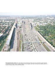
Success: By the late 1990s traffic congestion was a daily occurrence on the West Belt. This<br />
view looks north near Kempwood during the afternoon rush hour. The heavy traffic on the <strong>Beltway</strong><br />
has been a financial windfall for the Harris County Toll Road Authority, enabling it to expand<br />
the toll road system. Projects to expand the West and North sections of the <strong>Sam</strong> <strong>Houston</strong> <strong>Tollway</strong>,<br />
from the Southwest Freeway to the North Freeway, to eight lanes began in 2002 and are<br />
scheduled to be complete by 2005. Expansion work in progress can be seen in the distance in<br />
this photo (the light-colored concrete). (Photo: September 2002)<br />
<br />
$25 million in property within<br />
the next few weeks. It was still<br />
a challenging task, and one day<br />
before a decision had to be made<br />
about whether the first contract<br />
could be awarded on the agreedto<br />
date, the right-of-way acqui-<br />
<br />
sition job was not complete. On<br />
<br />
<br />
the decision day at 8:15 A.M.,<br />
Letz received the final right-ofaccess<br />
needed for the project.<br />
The job would go to bid, and the construction of <strong>Beltway</strong><br />
8 West was soon underway. 44<br />
The contract award for the short length of frontage<br />
roads in west <strong>Houston</strong> in 1983 marked the beginning of<br />
the wave of construction that would build <strong>Beltway</strong> 8.<br />
For 30 years the <strong>Beltway</strong> had moved forward one inch<br />
at a time, and often stood still. But now, TxDOT support<br />
and the newly created Harris County Toll Road Authority<br />
would push the <strong>Beltway</strong> into reality over the next 13<br />
years. TxDOT constructed the frontage roads and sections<br />
of main lanes on the North Belt and East Belt, as well<br />
as most of the interchanges at intersecting freeways. The<br />
section of frontage roads included in the <strong>Beltway</strong> 8 Group<br />
funding agreement was opened in December 1985. After<br />
that, frontage road sections opened regularly around the<br />
<strong>Beltway</strong>, culminating with the opening of the final section<br />
to complete the circular loop in southeast <strong>Houston</strong> near<br />
Hobby Airport in 1996. HCTRA took on the job of building<br />
the main lanes as a tollway, with initial work focusing<br />
on the West Belt and North Belt.<br />
<strong>Sam</strong> <strong>Houston</strong> <strong>Tollway</strong>, Cash Cow<br />
Proceeding with construction of the <strong>Beltway</strong> 8 Toll<br />
Road was somewhat of a leap of faith for Harris County<br />
Judge Jon Lindsay. Revenue studies had rated it as a mar-
The Loops 305<br />
ginal, risky project and indicated a strong chance the project<br />
would lose money. The same study predicted that the<br />
Hardy Toll Road would be profitable. But Lindsay pushed<br />
forward with the <strong>Beltway</strong> Toll Road. In July 1985 a ground<br />
breaking ceremony was held for the construction of the<br />
first segment of the tollway from the Southwest Freeway<br />
to the Katy Freeway. In 1986 the <strong>Beltway</strong> was named the<br />
<strong>Sam</strong> <strong>Houston</strong> <strong>Parkway</strong> and was designated as a scenic<br />
district to prevent the proliferation of billboards along the<br />
frontage roads. The tolled main lanes were designated as<br />
the <strong>Sam</strong> <strong>Houston</strong> <strong>Tollway</strong>. The <strong>Beltway</strong> became the first<br />
and only limited-access facility within the city of <strong>Houston</strong><br />
to be named after an individual—the first president of the<br />
Republic of Texas and namesake of the city of <strong>Houston</strong>.<br />
The first segment of the <strong>Sam</strong> <strong>Houston</strong> <strong>Tollway</strong> opened<br />
on June 29, 1988. The second section, from the Katy<br />
Freeway to the Northwest Freeway, opened in June 1989,<br />
and the third section, from the Northwest Freeway to the<br />
North Freeway, opened in July 1990. The <strong>Sam</strong> <strong>Houston</strong><br />
<strong>Tollway</strong> was unusual for a tollway in that it had continuous,<br />
toll-free frontage roads for its full length. 45<br />
Even before the first section of the <strong>Sam</strong> <strong>Houston</strong> <strong>Tollway</strong><br />
opened, Harris County officials had substantially<br />
lowered traffic and revenue projections. The collapse of<br />
<strong>Houston</strong>’s economy in the mid-1980s and the extended<br />
recession through the late 1980s had made the project’s<br />
original traffic projections obsolete. By mid-1989, one<br />
year after the opening of the first section of the <strong>Sam</strong> <strong>Houston</strong><br />
<strong>Tollway</strong> and the completion of the Hardy Toll Road,<br />
toll revenue was less than 50% of original projections. A<br />
revised projection predicted that long-term revenue would<br />
be 40% less than the original estimates. During 1989 there<br />
was frequent talk of the possible need for a subsidy from<br />
Harris County’s general tax revenue to meet toll road<br />
bond payments. By July 1990, Lindsay was warning that<br />
a $20 million annual subsidy from general tax revenue<br />
would be needed within two years. 46<br />
The third section of the <strong>Sam</strong> <strong>Houston</strong> <strong>Tollway</strong>, from<br />
the Northwest Freeway to the North Freeway, opened just<br />
as Lindsay delivered the financial bad news. Soon, however,<br />
the financial picture began to change. The complete,<br />
continuous tollway from Southwest <strong>Houston</strong> to Bush Intercontinental<br />
Airport caused a surge in traffic. Just three<br />
months after section three opened, Harris County officials<br />
were stating that a sharp increase in traffic resulting from<br />
the completion of section three had postponed the need for<br />
a subsidy for at least five years. 47<br />
The <strong>Sam</strong> <strong>Houston</strong> <strong>Tollway</strong> traffic boom had begun.<br />
Traffic and revenue surged ahead of projections during<br />
the 1990s, making the <strong>Sam</strong> <strong>Houston</strong> <strong>Tollway</strong> a cash cow<br />
for HCTRA. In the meantime, traffic and revenue on the<br />
Hardy Toll Road still lagged behind projections. It turned<br />
out that the original traffic projections in 1984, which predicted<br />
a successful Hardy Toll Road and a marginal <strong>Sam</strong><br />
<strong>Houston</strong> <strong>Tollway</strong>, had missed the mark on both facilities.<br />
But the success of the <strong>Sam</strong> <strong>Houston</strong> <strong>Tollway</strong> allowed<br />
HCTRA to easily cover the Hardy Toll Road revenue<br />
shortfall.<br />
Key dates in the history of <strong>Beltway</strong> 8-<strong>Sam</strong> <strong>Houston</strong> <strong>Tollway</strong><br />
1952 The Outer Belt is first proposed, originally as a major<br />
arterial street.<br />
1957 The first roads built on the Outer Belt alignment open.<br />
1960 The Outer Belt is designated as a freeway. Harris<br />
County takes ownership of the project.<br />
1969 The Outer Belt is adopted into the state highway<br />
system and officially named <strong>Beltway</strong> 8.<br />
1970 The first substantial section of the <strong>Beltway</strong>, a section<br />
of frontage roads, is completed in conjunction with the<br />
1969 opening of <strong>Houston</strong> Intercontinental Airport.<br />
1976 The <strong>Beltway</strong> is near death as the 1970s highway<br />
funding crisis makes new freeway construction<br />
impossible.<br />
1977 The <strong>Beltway</strong> is restored to long-term plans.<br />
1982 The <strong>Houston</strong> Ship Channel toll bridge is opened on<br />
May 6.<br />
1983 Harris county voters approve the creation of the Harris<br />
County Toll Road Authority (HCTRA).<br />
1985 In December a section of frontage roads opens in<br />
southwest <strong>Houston</strong>, launching the wave of construction<br />
that would build the <strong>Beltway</strong>.<br />
1988 The first main lanes built by HCTRA open.<br />
1989 <strong>Houston</strong>’s first five-level stack interchange is completed<br />
at the Katy Freeway.<br />
1994 HCTRA takes ownership of the ship channel bridge<br />
from the Texas Turnpike Authority on May 5.<br />
1996 The full <strong>Beltway</strong> is complete, either as a freeway,<br />
tollway, or frontage road.<br />
2005 Scheduled completion of expansion to 8 main lanes on<br />
the west and north <strong>Sam</strong> <strong>Houston</strong> <strong>Tollway</strong>.<br />
2007 Scheduled completion of the last remaining section of<br />
main lanes in northeast <strong>Houston</strong>.<br />
<br />
<br />
<br />
<br />
<br />
<br />
<br />
<br />
<br />
<br />
<br />
<br />
<br />
<br />
<br />
<br />
<br />
<br />
<br />
<br />
<br />
<br />
<br />
Cash cow: This plot shows traffic volume at the busiest point of the<br />
<strong>Sam</strong> <strong>Houston</strong> <strong>Tollway</strong> near Westheimer in west <strong>Houston</strong>.
306 <strong>Houston</strong> Freeways<br />
Northwest Freeway interchange: This view<br />
looks along the southbound <strong>Sam</strong> <strong>Houston</strong> <strong>Tollway</strong><br />
main lanes. This interchange was completed<br />
in 1990. (Photo: May 2003)<br />
Construction: This view looks east along the<br />
South Belt at the construction zone for the<br />
Gulf Freeway interchange in late 1996. (Photo:<br />
Williams Brothers Construction Company)
The Loops 307<br />
In the early 1990s HCTRA Executive Director Wesley<br />
Freise and Lindsay were negotiating with the Texas Turnpike<br />
Authority to take over the financially beleaguered<br />
<strong>Beltway</strong> 8 <strong>Houston</strong> Ship Channel Bridge, which was facing<br />
an inevitable default on its bonds in 1996. The bridge<br />
transfer to HCTRA occurred on May 5, 1994. As part of<br />
the deal, HCTRA received $90 million from TxDOT for<br />
the construction of the <strong>Sam</strong> <strong>Houston</strong> <strong>Tollway</strong> between the<br />
La Porte Freeway (SH 225) and the Southwest Freeway<br />
(US 59), as well as TxDOT’s commitment to build interchanges<br />
at the Southwest and Gulf Freeways estimated to<br />
cost $120 million. The southeast section opened in July<br />
1996, the south section opened in March 1997, and the<br />
southwest section opened in May 1997. With those openings<br />
and additional progress on freeway sections of <strong>Beltway</strong><br />
8 in north and northeast <strong>Houston</strong>, only one section of<br />
<strong>Beltway</strong> 8 did not have its main lanes in place. That section<br />
in northeast <strong>Houston</strong>, from the Crosby Freeway (US<br />
90) to the Eastex Freeway (US 59), is expected to begin<br />
construction in 2005 and be completed in 2007 as a tollway.<br />
Traffic congestion on the west and north <strong>Sam</strong> <strong>Houston</strong><br />
<strong>Tollway</strong> prompted HCTRA to move forward with<br />
plans to widen the <strong>Sam</strong> <strong>Houston</strong> <strong>Tollway</strong> to eight main<br />
lanes from the Southwest Freeway to the North Freeway.<br />
The widening projects began in 2002 and are scheduled to<br />
be completed in 2005.<br />
The Airport and the <strong>Beltway</strong><br />
The 1950s was a decade for big infrastructure dreams<br />
to take root. <strong>Houston</strong>’s freeway system was put on the<br />
map in the early 1950s, and the <strong>Beltway</strong> was first proposed<br />
in 1952. Another important part of <strong>Houston</strong>’s transportation<br />
infrastructure, its major airport, also was taking<br />
shape in the 1950s. As initial planning for a major airport<br />
took place, one thing became clear: the airport and the<br />
<strong>Beltway</strong> would go hand-in-hand. All potential airport locations<br />
were located immediately adjacent to the <strong>Beltway</strong>,<br />
and a site along the North Belt was purchased in 1957 and<br />
officially designated for the airport in 1960. The new airport<br />
provided the impetus for the construction of the first<br />
significant section of <strong>Beltway</strong> 8 in 1970—the only substantial<br />
section in existence for 12 years until the opening<br />
of the <strong>Beltway</strong> 8 ship channel toll bridge in 1982.<br />
The story of <strong>Houston</strong>’s major airport is in many ways a<br />
contrast to the story of the development of <strong>Houston</strong>’s freeway<br />
network. While local authorities aggressively developed<br />
plans for the first-class freeway network in the early<br />
1950s and worked hard to make it happen, the issue of<br />
<strong>Houston</strong>’s airport was plagued by indecision and miscues.<br />
With the help of local business interests, the wheels were<br />
belatedly set into motion in 1957, and after numerous delays<br />
the airport finally opened in 1969. Construction and<br />
expansion of roads and freeways around the airport played<br />
out slowly after the opening of the airport, with significant<br />
momentum finally getting underway in the 1980s and major<br />
area-wide construction taking place in the 1990s.<br />
History of Bush Intercontinental Airport<br />
Today’s William P. Hobby Airport was the city of<br />
<strong>Houston</strong>’s first airport, opening in 1937 as <strong>Houston</strong> Municipal<br />
Airport on the site of a private airfield. By the early<br />
1950s it became evident that the airport would not be<br />
able to meet <strong>Houston</strong>’s expanding aviation needs. In 1951<br />
the city of <strong>Houston</strong> contracted for the first study of a second<br />
major airport for <strong>Houston</strong>. The study—known as the<br />
Bourne Study—identified three potential airport sites<br />
along the present-day <strong>Beltway</strong> in northwest <strong>Houston</strong>.<br />
However, no action was taken after the release of the report.<br />
In the early 1950s the second major airport was still<br />
largely in the discussion stage and officials were not ready<br />
to commit to the new airport. In the meantime, officials<br />
moved forward with the construction of a new terminal at<br />
<strong>Houston</strong> Municipal Airport. The terminal design was declared<br />
to be inadequate by <strong>Houston</strong> Mayor Roy Hofheinz<br />
during construction, necessitating changes to correct glaring<br />
problems. Unfortunately, the planning errors in the<br />
terminal proved to be somewhat prophetic about the future<br />
of aviation planning in <strong>Houston</strong>. In October 1954 the<br />
new terminal opened and the airport was renamed <strong>Houston</strong><br />
International Airport. 48<br />
Through the mid-1950s the need for a new airport<br />
became increasingly urgent, but city officials were slow<br />
to take action. In 1957 several events converged to finally<br />
move <strong>Houston</strong>’s second airport forward. While the coming<br />
of the “jet age” of commercial air service had been<br />
anticipated since before 1950, it finally arrived in <strong>Houston</strong><br />
on May 20, 1957, when a French-built Caravelle jet arrived<br />
from Miami while on a demonstration tour through<br />
the United States. The medium-range, twin-engine Caravelle<br />
had no difficulty with the short 6,565-foot (2,001 m)<br />
runway at <strong>Houston</strong> International, but aviation authorities<br />
knew that the runway length would not be adequate for<br />
the imminent wave of new jets that would soon arrive<br />
from U.S. manufacturers: the Boeing 707, the Douglas<br />
DC-8, and the Convair 880. A planned runway extension<br />
to 7,300 feet (2,225 m) would be enough to accommodate<br />
the new jet aircraft for departures to domestic destinations,<br />
but still would not be adequate for a jet departing<br />
on an overseas flight. It slowly became clear that <strong>Houston</strong><br />
had underinvested in its aviation facilities and was falling<br />
behind the nation’s other major cities in its aviation<br />
infrastructure. The <strong>Houston</strong> Chronicle published a series<br />
of articles comparing <strong>Houston</strong>’s aviation efforts to those<br />
of Dallas. The Chronicle concluded that <strong>Houston</strong> had<br />
“stood still” in the preceding years while Dallas had a<br />
well-planned program of promoting its aviation activities.<br />
Word that <strong>Houston</strong> is losing ground to its rival Dallas is<br />
often enough to spur action. 49<br />
The Jet Era Arrives and Becomes the Jetero<br />
The most significant event of 1957, however, was<br />
the action of a group of <strong>Houston</strong> businessmen who effectively<br />
took matters into their own hands to move the<br />
second airport forward while local authorities dawdled.<br />
The group of businessmen formed an entity called the
308 <strong>Houston</strong> Freeways<br />
The <strong>Beltway</strong> and the airport—together from the beginning: This 1959 map from the <strong>Houston</strong> City Planning Department<br />
shows the potential airport sites that were considered. All potential sites were located along the <strong>Beltway</strong>. The first<br />
study for the location for a new airport was conducted in 1951 and identified the three Bourne sites. In 1960 a study delivered<br />
the final site recommendation. The “Bourne West #1” location, the preferred site in 1951, was rejected because of<br />
high land cost and flight patterns over newly urbanized areas. The “Bourne North #2” site offered no advantages over the<br />
Jetero site but would have been more difficult to acquire. The “Bourne Northwest #3” was rejected because of development,<br />
including a power plant and high voltage lines. The Addicks Reservoir location was rejected due to the high cost to<br />
raise the site above flood level, potential compromise of flood control capability, and flight patterns over urbanized areas.<br />
The Blue Ridge prison farm site southwest of <strong>Houston</strong> was determined to be unsuitable for an airport. The winner: the<br />
Jetero site. 50<br />
Jet Era Ranch Corporation, which purchased a 3,126-acre<br />
tract of land 15 miles (24 km) north of downtown <strong>Houston</strong><br />
for $1,860,938.27. The group held the property for resale<br />
to the city of <strong>Houston</strong> at the original purchase price for<br />
use as the site of <strong>Houston</strong>’s new airport. The intended<br />
name of the land-holding entity—the Jet Era Ranch<br />
Corporation—turned out to be short-lived. A secretary’s<br />
typographical error transformed the words “Jet Era” into<br />
the single word “Jetero” in an early planning document.<br />
From that point on, the airport site became known as the<br />
Jetero airport site. The name Jetero would persist until<br />
1983 when it was retired as the name of one of the main<br />
entrances to the airport. 51<br />
While the land was now in hand, several formalities
The Loops 309<br />
had to be taken care of. In July 1959 <strong>Houston</strong> voters approved<br />
a $50 million bond issue that included $6 million<br />
in airport development funds. In April 1960, in response<br />
to Mayor Lewis Cutrer’s request for a comprehensive<br />
evaluation of all potential airport sites, a report was issued<br />
titled Review and Evaluation of Proposed Major Airport<br />
Sites to Serve the <strong>Houston</strong> Area. This report enumerated<br />
the known deficiencies of the existing <strong>Houston</strong> International<br />
Airport and identified the Jetero airport site as the<br />
only suitable candidate for the new airport. The legal<br />
agreements to officially accept the Jetero airport site and<br />
make final payment of principal and interest were completed<br />
in June 1960.<br />
Planning for the Airport and its Freeways<br />
The first engineering report for the new airport, Plan of<br />
Development, Jetero Intercontinental Airport, was issued<br />
in October 1961. The name of the airport site—”Jetero”—<br />
was transferred directly into the new airport name. The<br />
1961 document envisioned a single circular-shaped terminal<br />
with several concourses extending from it. In terms of<br />
roadways, the document specified access roads that would<br />
be required. Most significant was the call for immediate<br />
action to construct the nearby section of the Outer Belt,<br />
the present-day <strong>Beltway</strong> 8.<br />
The second major airport planning document was issued<br />
in July 1963 and was titled Volume II, Plan of Development,<br />
Terminal Area, <strong>Houston</strong> Intercontinental Airport.<br />
The “Jetero” designation for the airport was gone, but it<br />
would find a second life as the name for one of the main<br />
entrance roadways to the airport. This second planning<br />
document detailed the comprehensive study that had been<br />
undertaken in order to determine the best terminal configuration<br />
for the new airport. Planning officials visited<br />
all the major U.S. airports and had extensive consultations<br />
with airport authorities. Four terminal concepts were selected<br />
for detailed study: the mobile lounge, pier, satellite,<br />
and unit terminal. The mobile lounge concept, which was<br />
in use at Dulles airport near Washington, D.C., featured<br />
bus-type vehicles that shuttled passengers between the<br />
main terminal and aircraft. The pier concept most closely<br />
resembled the original design and featured a central unit<br />
for all airline operations with pier structures housing<br />
gates radiating from the central unit. The satellite concept<br />
also featured a single central unit, but aircraft would be<br />
grouped around individual satellite buildings that were<br />
connected to the main terminal. The unit terminal concept<br />
featured a series of relatively small, stand-alone terminals<br />
constructed along a central mall.<br />
The engineers and architects unanimously recommended<br />
the unit terminal design, mainly because it best<br />
met the requirements of flexibility and expandability. In<br />
addition, it would distribute traffic among several terminals<br />
rather than one terminal, and it would avoid the<br />
sprawl and long passenger walking distances that would<br />
eventually occur in a single-terminal design. Although the<br />
unit terminal appeared to be the best design at the time, it<br />
would prove to be less than optimal for the airline hub and<br />
The jet era becomes Jetero: The site for Bush Intercontinental Airport<br />
was originally purchased by a group of civic-minded <strong>Houston</strong><br />
businessmen in 1957 to preserve the site until the city of <strong>Houston</strong><br />
could formulate a plan for a second airport. The holding company<br />
for the land was named the Jet Era Ranch Corporation, but a typographical<br />
error transformed the words “Jet Era” into “Jetero” and<br />
the airport site subsequently became known as the Jetero airport<br />
site. Although the name Jetero was no longer used in official planning<br />
documents after 1961, the eastern entrance to the airport<br />
was named Jetero Boulevard. In 1983, on the recommendation of<br />
<strong>Houston</strong> City Council member Eleanor Tinsley, Jetero Boulevard<br />
was renamed Will Clayton <strong>Parkway</strong> in honor of the cofounder of<br />
the Anderson, Clayton & Co. cotton trading firm and undersecretary<br />
of state for economic affairs from 1940 to 1948. Tinsley and other<br />
political officials felt that the 1950s-sounding name Jetero was not<br />
good for <strong>Houston</strong>’s image. However, nostalgia buffs may have been<br />
disappointed. The name Jetero recalled an era when jet travel<br />
promised to revolutionize travel opportunities—a time when the<br />
roar of a jet engine or a condensation trail in the sky inspired awe.<br />
(Photo: <strong>Houston</strong> Airport System)<br />
spoke operations that would later dictate airport design.<br />
The city of <strong>Houston</strong> adopted the unit terminal design on<br />
September 9, 1963.<br />
The next major engineering report, Volume III, Plan<br />
of Development, Land Use, <strong>Houston</strong> Intercontinental<br />
Airport, was issued in December 1964. This was the first<br />
document to provide details on the two planned entrance<br />
roadways, John F. Kennedy Boulevard from the south and<br />
Jetero Boulevard on the east. The document specified a<br />
400-foot (122 m) right-of-way to accommodate eventual<br />
construction of limited-access main lanes, frontage roads,<br />
and mass transit service. Initially, Kennedy Boulevard<br />
would be constructed as a four-lane divided roadway and<br />
Jetero Boulevard would be constructed as a four-lane divided<br />
roadway within the airport property and a two-lane<br />
roadway between the airport and the Eastex Freeway.<br />
At this point, all the plans were in place to build the<br />
airport. In fact, the initial north-south runway was completed<br />
in 1964 before any terminal construction. Terminal<br />
construction dragged on two years after the scheduled<br />
completion date in 1967 because of labor problems that
310 <strong>Houston</strong> Freeways<br />
Airport construction, August 1964: This view looks north-northwest at the construction<br />
site for the airport. The north-south runway was already complete and work<br />
was underway on the east-west runway in the upper right of the photo. Land for the<br />
terminal complex between the two runways had been cleared. Due to labor problems<br />
and project management difficulties experienced by the contractor responsible<br />
for the terminal, completion of the airport was delayed two years. <strong>Houston</strong> Intercontinental<br />
Airport began operations on June 8, 1969. (Photo: <strong>Houston</strong> Airport System)<br />
<br />
<br />
<br />
plagued the prime contractor, R. F. Ball Construction. Finally,<br />
on Sunday, June 1, 1969, <strong>Houston</strong> Intercontinental<br />
Airport was officially dedicated in a large ceremony featuring<br />
an air show, an open house of the entire airport, and<br />
the usual political ceremonies. The first regular-service<br />
commercial flight landed one week later on June 8 when<br />
the airport officially opened for business.<br />
Unfortunately, the pattern of aviation miscues in <strong>Houston</strong><br />
soon reared its head again. It turned out that the longest<br />
runway at <strong>Houston</strong> Intercontinental, the 9,400-footlong<br />
(2,865 m) east-west runway, was not long enough<br />
to allow a fully-loaded wide-body aircraft to take off for<br />
long-range flights during warm weather conditions. Air<br />
France’s nonstop service to Europe incurred a 10,000-<br />
pound (4,535 kg) weight penalty due to the short runway.<br />
In addition, the runways were not thick enough to handle<br />
the weight of newly introduced wide-body aircraft, and<br />
the paved area of the taxiways did not extend far enough<br />
<br />
<br />
<br />
<br />
<br />
from taxiway edges to prevent ground erosion due to jet<br />
blast. The new “jet era” airport wasn’t even capable of<br />
handling all jets. To add further insult to injury, <strong>Houston</strong>’s<br />
rival 250 miles (400 km) to the north had just begun work<br />
on the massive Dallas-Fort Worth International Airport.<br />
Dallas-Fort Worth International Airport would become<br />
the world’s largest airport and would be served by a<br />
sprawling freeway network.<br />
The next engineering report, Volume IV—Plan of Development,<br />
Second Stage, was released in April 1971 and
The Loops 311<br />
Original JFK Boulevard connection ramps, 1970-1992: This August 1978 view looks west<br />
along the North Belt frontage road at the original connection ramps at John F. Kennedy Boulevard.<br />
The ramps were dismantled and replaced in 1992 during the construction of the <strong>Beltway</strong><br />
main lanes. (Photo: Texas Transportation Institute)<br />
<br />
<br />
<br />
<br />
North Belt at JFK Boulevard: This photo shows the same view as the above photo in May 2003.
312 <strong>Houston</strong> Freeways<br />
Key dates in the history of Bush Intercontinental Airport<br />
1951 The first study of potential airport sites is completed.<br />
1957 Local business leaders purchase the airport site<br />
with a land holding-entity called the Jet Era Ranch<br />
Corporation.<br />
1960 Voters approve bonds for the airport.<br />
1969 The airport opens on June 8, 1969, after a long delay in<br />
completing the terminal.<br />
1981 Terminal C opens, and Continental Airlines begins<br />
building its <strong>Houston</strong> hub operation.<br />
1990 The International Airlines Terminal opens.<br />
1997 The airport is renamed George Bush Intercontinental<br />
Airport/<strong>Houston</strong>, in honor of nation’s 41st president who<br />
served from 1989 to 1993.<br />
2002 For passenger traffic, the airport is the 8th busiest in<br />
the United States and 13th busiest in the world.<br />
2003 The new $225 million Terminal E opens, with 23 gates.<br />
focused on correcting the airport’s runway shortcomings<br />
as quickly as possible. The 8,000-foot (2,438 m) northsouth<br />
runway was slated to be lengthened to 12,000 feet<br />
(3,657 m). Runways and taxiways would be thickened<br />
where necessary. In terms of roadways, the 1971 plan<br />
reaffirmed previous plans. The cross section view of the<br />
entrance roadways, Kennedy and Jetero Boulevards, now<br />
showed a 450-foot-wide (137 m) corridor. The document<br />
also included an expanded discussion of mass transit service<br />
to the airport in recognition of the increasingly freeway-hostile<br />
climate of the early 1970s and greater interest<br />
in mass transit. However, it was recognized that a mass<br />
transit system was at least 10 to 15 years in the future.<br />
Perhaps the lowest point in the history of <strong>Houston</strong><br />
Intercontinental Airport—at least psychologically—occurred<br />
in the 1970s when <strong>Houston</strong> was not a hub airport<br />
and many travelers were forced to make connections at<br />
Dallas-Fort Worth International Airport. For <strong>Houston</strong>ians,<br />
having to connect through Dallas was perhaps the ultimate<br />
slap in the face. Attracting a large airline to call <strong>Houston</strong><br />
its home became a top priority of local officials. The<br />
completion of Terminal C in 1981 provided a terminal<br />
facility capable of handling a hub operation, and in 1982<br />
Continental Airlines moved its headquarters to <strong>Houston</strong>.<br />
Starting around that time, Continental began building its<br />
<strong>Houston</strong> hub. Finally, <strong>Houston</strong> Intercontinental Airport<br />
had overcome its growing pains and was now positioned<br />
to propel itself into the upper tier of U.S. airports. 52<br />
The 1990s and 2000s saw ongoing improvements to<br />
the airport. In 1990, the International Airlines Terminal<br />
Building opened. Later in the 1990s, the circular gate facilities<br />
at Terminal A, which had a distinctive 1960s feel<br />
and seemed to be reminiscent of the 1950s-sounding term<br />
“Jetero,” were demolished and replaced with linear gate<br />
facilities. The circular facilities at Terminal B were retained,<br />
however, even as Continental’s hub operation expanded<br />
into Terminal B. In May 2002, a 6,000 foot (1,829<br />
m) runway was lengthened to 10,000 feet (3048 m) for<br />
full jet service, and in 2003 an all-new, 9,400-foot (2,865<br />
m) runway opened. With the addition of the new runway,<br />
the airport’s land area exceeded 10,000 acres. The first<br />
phase of the new Terminal E was dedicated in June 2003.<br />
In 2002, <strong>Houston</strong>’s Bush Intercontinental Airport<br />
ranked as the 8th busiest airport in the United States and<br />
the 13th busiest airport in the world as measured by total<br />
passengers. It was a remarkable level of success for an<br />
airport that had been plagued with so many problems during<br />
its development and was not ideally situated for airline<br />
hub operations. To complement its world-class freeway<br />
system, <strong>Houston</strong> also had an airport that reached worldclass<br />
status. 53<br />
The Roads and Freeways<br />
Improvements to the roads and freeways serving Bush<br />
Intercontinental Airport were completed around the time<br />
of the airport opening in June 1969. The Eastex Freeway<br />
from downtown to the airport entrance was upgraded to<br />
full freeway status by 1970. The <strong>Beltway</strong> 8 frontage roads<br />
between the North and Eastex Freeways were opened in<br />
February 1970. The North Freeway had been completed<br />
in 1963. The southern entrance to the airport, John F. Kennedy<br />
Boulevard, was a four-lane divided highway, and the<br />
eastern entrance to the airport, Will Clayton <strong>Parkway</strong>, was<br />
a four-lane divided highway inside the airport and a twolane<br />
roadway outside the airport. During the 1970s there<br />
were almost no freeway or roadway improvements in the<br />
vicinity of the airport.<br />
Freeway construction resumed in the mid-1980s. In<br />
1983 work was underway to construct the <strong>Beltway</strong> 8<br />
main lanes near the airport. The Hardy Toll Road opened<br />
in 1987. The 1990s brought a construction boom to airport-area<br />
freeways. The <strong>Beltway</strong> 8 main lanes between<br />
the North and Eastex Freeways were completed in bits<br />
and pieces, with the final section at the Eastex Freeway<br />
opening in December 2002. A four-level interchange at<br />
Kennedy Boulevard with two direct connectors was completed<br />
in 1992. Major expansion of the North Freeway<br />
west of the airport was completed in 1998. Expansion of<br />
the Eastex Freeway was completed in 1999. The Hardy<br />
Toll Road airport connector opened in January 2000. The<br />
five-level stack interchange at <strong>Beltway</strong> 8 and the North<br />
Freeway saw its first phase open in 1997 and was fully<br />
completed in early 2003. The first connector ramp at the<br />
interchange of the North Belt and Eastex Freeway opened<br />
in December 2002, and the second phase, in progress in<br />
2003, will add three more direct connector ramps.<br />
But what about the entrance roadways to the airport?<br />
Will they ever become freeways? In the long run, the<br />
answer to that question is probably yes, but in the short<br />
and intermediate planning horizons neither John F. Kennedy<br />
Boulevard nor Will Clayton <strong>Parkway</strong> will become<br />
a freeway. John F. Kennedy Boulevard will be the first to<br />
become a full freeway since only one traffic light needs to<br />
be eliminated. The lightly-travelled Will Clayton <strong>Parkway</strong><br />
will probably have to wait a very long time for freeway<br />
status.
The Loops 313<br />
Will it ever be a freeway? This view looks west along Will Clayton <strong>Parkway</strong>, the former<br />
Jetero Boulevard and one of two entrances to Bush Intercontinental Airport. The roadway is<br />
in a frontage road configuration and has a wide right-of-way for its ultimate planned freeway<br />
status. However, traffic volumes entering the airport on Will Clayton <strong>Parkway</strong> are low, so<br />
construction of freeway main lanes is in the distant future. (Photo: May 2002)