June 2005 Update: The US 59/IH-10
June 2005 Update: The US 59/IH-10
June 2005 Update: The US 59/IH-10

You also want an ePaper? Increase the reach of your titles
YUMPU automatically turns print PDFs into web optimized ePapers that Google loves.
Downtown Freeways 119<strong>The</strong> double deck that wasn’t: Early concepts for downtown Houston freeways included possibledouble-deck freeways, such as this one that was contemplated for <strong>IH</strong> <strong>10</strong> on the north side ofdowntown. Although downtown Houston has many elevated freeways, no double-deck structureswere built. <strong>IH</strong> <strong>10</strong> north of downtown, opened on May 17, 1972, was the next-to-last segment oforiginally-planned downtown freeway main lanes to open. (Photo: TxDOT)for the downtown interchange complex was slightly differentfrom the final plan. In the 1953 plan, the SouthwestFreeway followed the present-day route of Spur 527 allthe way to <strong>IH</strong> 45 on the southwest side of downtown (seeplan map, page 13). 2In 1954 the freeway master plan was adjusted, bringingthe downtown interchange complex to its near final generalconfiguration. In the final plan, Spur 527 was strictlya part of the Southwest Freeway distribution system intodowntown streets. With the final and official plan in place,it was clear that Houston’s downtown freeway complexwould be extensive. It featured two major multiplex freewayinterchanges, where two freeways would run parallelto each other—one on the north side of downtown with <strong>IH</strong>45 and <strong>IH</strong> <strong>10</strong>, and one on the south side of downtown with<strong>US</strong> <strong>59</strong> and SH 288. <strong>The</strong>re would be two stack-type interchanges,one at <strong>US</strong> <strong>59</strong> and <strong>IH</strong> 45, and one at <strong>US</strong> <strong>59</strong> and<strong>IH</strong> <strong>10</strong>. <strong>IH</strong> 45 on the west side of downtown would featurean elevated complex of ramps connecting to downtownand the parkways along Buffalo Bayou. All downtownfreeways would be elevated above grade or depressedbelow grade.<strong>The</strong>re were still many details to be worked out. In May1957, city of Houston planning director Ralph Ellifrit andTxDOT Houston Urban Project Office head A. C. Kysermet in Kyser’s office to plan details of the downtownfreeways. Two days later Ellifritsummarized their plans in a lettertitled “Central InterchangeStudy.” <strong>The</strong> letter detailed how theexisting downtown street systemwould be fully integrated into the freeway system by assigningat least four feeder streets to each radial freeway.To increase the merging distance between the <strong>US</strong> <strong>59</strong>-SH288 interchange and nearby <strong>US</strong> <strong>59</strong>-<strong>IH</strong> 45 interchange,Ellifrit recommended a southward shift of the <strong>US</strong> <strong>59</strong>-SH288 interchange. Most of the ideas contemplated in theMay 1957 meeting, including the southward shift of the<strong>US</strong> <strong>59</strong>-SH 288 interchange, would become part of the finalplan. Houston’s downtown freeways were designatedas the Houston Central Interchange. 3In August 1960, the Texas Transportation Commissionclosed the last remaining gap in the downtown freewaysystem by formally approving <strong>US</strong> <strong>59</strong> between Spur 527and <strong>IH</strong> 45. Part of this newly approved section would becomethe widest and most impressive freeway segment inthe downtown area. 4In 1963 the overall plan for the downtown Houstonfreeway system was finalized. <strong>The</strong>re would subsequentlybe only three significant changes to this plan. First, theinterchange at the intersection of the planned HarrisburgFreeway and <strong>US</strong> <strong>59</strong> would never be built, since the Harris-
120 Houston FreewaysClearing the path: Right-of-way clearance for present-day <strong>IH</strong> 45 on the west side ofdowntown was complete when this photo was taken on August 3, 1954. This sectionof freeway was the first to be constructed in downtown Houston. <strong>The</strong> parallel rows ofbuildings in the upper right of the photo are part of the Allen Parkway Village housingproject. (Photo: Squire Haskins Photography, Dallas)burg Freeway was later cancelled. Second, a third freewaymultiplex would be added southeast of downtown along<strong>IH</strong> 45 where SH 35, the planned Alvin Freeway, mergedwith <strong>IH</strong> 45. And third, the Eastex Freeway interchangecomplex on the northeast side of downtown, including theinterchange with <strong>IH</strong> <strong>10</strong>, would be substantially expandedin work that began in the late 1990s. 5Clearing the WayMost of the right-of-way clearance for Houston’sdowntown freeways consisted of residential structures,with some areas of low grade commercial structures andlight industry also affected. <strong>The</strong> older, decayed neighborhoodsaround downtown Houston worked in favor of thefreeway builders. Although slum clearance was muchless pervasive in Houston than it was in older easterncities, two of Houston’s best examples of slum clearanceoccurred immediately adjacent to downtown freeways.<strong>The</strong> Allen Parkway Village project, originally known asSan Felipe Courts, was opened in 1942 and <strong>IH</strong> 45 wasconstructed along its eastern edge in 1955. * <strong>The</strong> ClaytonHomes housing project was built just northeast of*Allen Parkway Village became the focus of a long-running, highly contentiouscontroversy when the city of Houston began efforts to demolishit in the mid-1970s. In early 1996 a compromise plan was approved, and677 of the 963 units were demolished in 1996 and 1997. <strong>The</strong> controversywas not related to the adjacent <strong>IH</strong> 45 freeway.
Construction begins: This 1954 photoshows the first construction on thedowntown Houston freeway system—the first phase of <strong>IH</strong> 45 on the westside of downtown. This view lookseast along Allen Parkway. (Photo:Greater Houston Partnership)<strong>The</strong> first downtown freeway: Thisshort section of <strong>IH</strong> 45 on the west sideof downtown opened on December12, 1955. This photo was taken withintwo years of the opening and lookssoutheast, similar to the perspectiveof the photo on the opposite page.(Photo: TxDOT)
122 Houston FreewaysFew obstacles to freeways: Downtown Houston presented fewobstacles to freeway construction. <strong>The</strong> map above shows the locationsof the freeway sections that presented some difficulty.downtown in 1952, and in 1958 <strong>US</strong> <strong>59</strong> was constructedalongside the property. <strong>The</strong> largest right-of-way clearancefor the downtown freeway system occurred in the late1960s on the south side of downtown, where a very widecorridor was required for the <strong>US</strong> <strong>59</strong>-SH 288 interchange.<strong>The</strong>re were generally no objections to the displacement ofresidences in the neighborhoods around downtown.Another possible roadblock to freeway constructionwas the parkland along Buffalo Bayou just west of downtown,adjacent to the Houston Civic Center. A web ofelevated structures and connection ramps was envisionedfor <strong>IH</strong> 45 through that section of downtown. In a 1979interview, Ralph Ellifrit remarked that “there was considerablediscussion” about building a freeway at that location,but “there was just no way” to build the downtownfreeway system without routing the freeway there. Timewould prove that the freeway would not have a negativeimpact on the park or downtown civic center. 6On the east side of downtown, <strong>US</strong> <strong>59</strong> needed to passover a rail yard which included Union Station, one of thecity’s railway stations for passenger service. In 1953 thecity of Houston began efforts to relocate Union Station,which was controlled by the Houston Belt and TerminalRailroad, to Southern Pacific Railroad’s Grand CentralStation. City planners envisioned connecting the EastexFreeway (<strong>US</strong> <strong>59</strong> north of downtown) into the street immediatelyadjacent to the elevated structure, Chartres, and thethree parallel streets to the west, using a distribution systemsimilar to the “loading platform” where the Gulf Freewaydistributed traffic into downtown. However, UnionStation blocked three of the four streets which would connectto the freeway, making the distribution system impractical.Efforts to relocate the station continued throughthe mid-1950s, with negotiations breaking down by 1958.In 1960 the matter needed to be resolved so constructioncould move forward. On November 2, 1960, officialsfrom the city of Houston, TxDOT, and the railroadreached an agreement after a one-and-a-half hour session.<strong>The</strong> railroad agreed to relocate some tracks to providespace for the columns of the <strong>US</strong> <strong>59</strong> elevated structure, butthe Union Station itself would stay. As a result, the EastexFreeway would lack a full distribution system into downtownin its original construction, since the railroad stationblocked the needed feeder streets. <strong>The</strong> Eastex Freeway’spoor downtown connections would not be improved untilthe major reconstruction of the <strong>US</strong> <strong>59</strong>-<strong>IH</strong> <strong>10</strong> interchangebegan in the late 1990s. Around the same time, constructionof a new baseball stadium began at the location ofthe former Union Station. <strong>The</strong> stadium, opened in March2000, blocked the originally planned street access to thenew interchange from the east side of downtown. 7<strong>The</strong> most controversial section of downtown freewayimpacted commercial property, not residential areas orparks. <strong>IH</strong> 45 on the south side of downtown, now knownas the Pierce Elevated, required acquisition of propertyslated for commercial development by its owners. Twobank structures were planned for the corner of Main andPierce, right in the path of the freeway. In 1956 the cityof Houston refused to issue building permits to the landownersin order to keep the property clear for the freeway.However, freeway construction was estimated tobe 8 to <strong>10</strong> years in the future, and TxDOT did not havefunds available to acquire the right-of-way. <strong>The</strong> landownerscouldn’t improve their property, but there was no moneyavailable to buy it. In 1957 two landowners filed identicallawsuits to overturn the denial of building permits. <strong>The</strong>city was forced to rescind the “building lines” * it had es-(Opposite page) <strong>The</strong> spaghetti bowl: <strong>The</strong> upper photo, taken in May 1961, shows construction in progress to complete<strong>IH</strong> 45 on the west side of downtown. <strong>The</strong> project included the addition of collector-distributor structures and numerousconnection ramps. Engineers dubbed the new interchange the “spaghetti bowl” because of its long, stringlike roadways.<strong>The</strong> term “spaghetti bowl” had fallen into disuse by the 1970s. <strong>The</strong> lower image shows a modern view of <strong>IH</strong> 45 on thewest side of downtown. <strong>The</strong> configuration of the freeway remains unchanged since its completion in 1962. (Photos: upper,TxDOT; lower, September 2002)*“Building lines” were set by the city of Houston and Harris County to define the needed right-of-way for freeways. In general, building permits werenot issued for improvements to property within the building lines.
Downtown Freeways 123
124 Houston FreewaysAiming for the downtown crossing: This view shows the terminus of the EastFreeway (<strong>IH</strong> <strong>10</strong>) at <strong>US</strong> <strong>59</strong> in May 1961. Right-of-way clearance for <strong>IH</strong> <strong>10</strong> on the northside of downtown had not yet begun. A substantial number of structures were in thepath of the freeway in the mostly industrial area. <strong>The</strong> westward extension of <strong>IH</strong> <strong>10</strong>was completed on May 17, 1972. (Photo: TxDOT)tablished, leaving the corridor at risk for development.By October 1958, the building lines were reestablishedand TxDOT began protective right-of-way acquisition.But lack of funds limited the land acquisition to onlya half-block wide strip along Pierce Avenue. <strong>The</strong> halfblockstrip was estimated to cost $8 million and had afinal cost of $11 million. A full block strip was estimatedat $20 million. After adjusting for inflation in the overallU.S. economy to equivalent values in 2003 dollars, $11million translates to about $56 million and $20 milliontranslates to about $<strong>10</strong>2 million—a large but not dauntingcost. However, as a percentage of budgets at the time, $20million for a full block along Pierce Avenue would havebeen a huge expenditure. <strong>The</strong> total TxDOT budget for allof Texas in 1957 totaled $242 million. In relative terms,the cost of a full block along Pierce in 1957 corresponds toabout $430 million in TxDOT’s 2003 budget of $5.2 billion.<strong>The</strong>re was discussion of acquiring the full block, butlimited financial resources ruled it out; getting the moneyto buy the half-block strip would be difficult enough. Butthe half-block strip was wide enough for a freeway withonly six lanes. <strong>The</strong> consequences of the 1956 decision toacquire only half a block were being felt in 2003, whenTxDOT officials were studying ways to provide relief tothe now critically congested Pierce Elevated. 8Controversy over the Pierce Elevated persisted until19<strong>59</strong>, when a landowner was still fighting to have thebuilding lines revoked. By that time, local authoritieswere not willing to entertain any ideas that would changethe alignment of the freeway. TxDOT Houston UrbanProject Office head A. C. Kyser stated that changing theroute was out of the question, and the Houston Chamberof Commerce rallied its support behind the Pierce Elevated.By July 1960 all challenges to the Pierce Elevatedhad been dismissed, and approximately half the neededright-of-way had been acquired through protective rightof-waypurchases. 9
Downtown Freeways 125Building the Freeways<strong>The</strong> first construction on downtown Houston freewayswas underway by late 1953, consisting of the first phase ofpresent-day <strong>IH</strong> 45 on the western edge of downtown. <strong>The</strong>first freeway section, the main freeway lanes of <strong>IH</strong> 45,opened December 12, 1955. For the next 25 years therewould be a steady progression of work on the HoustonCentral Interchange (see map on page 118 with completiondates). On April 11, 1958, the Eastex Freeway wasextended into downtown with the opening of the BuffaloBayou bridge. <strong>The</strong> Southwest Freeway and its distributionsystem into downtown via Spur 527 were completedon July 26, 1961. On July 24, 1962, <strong>IH</strong> 45 was completedfrom the north side of Houston into downtown, formingthe first phase of the large <strong>IH</strong> 45-<strong>IH</strong> <strong>10</strong> multiplex. <strong>The</strong> <strong>IH</strong>45 interchange structure on the west side of downtownwas also finished in 1962 with the addition of collectorlanes and connector ramps. In April 1966 the <strong>US</strong><strong>59</strong> elevated structure on the east side of downtown wascompleted. Construction of the Pierce Elevated structurewas complete in spring 1965, and it was opened to trafficon August 18, 1967, connecting the North Freeway to theGulf Freeway. On December 20, 1968, the Katy Freeway(<strong>IH</strong> <strong>10</strong> West) was brought into downtown Houston, andthe multiplex interchange with <strong>IH</strong> 45 was substantiallycomplete. On May 17, 1972, <strong>IH</strong> <strong>10</strong> on the north sideof downtown between <strong>IH</strong> 45 and <strong>US</strong> <strong>59</strong> was opened,completing <strong>IH</strong> <strong>10</strong> through Houston and the inner loopof freeways around downtown. <strong>The</strong> last major link in thedowntown freeway system was finished on September 27,1974, with the opening of <strong>US</strong> <strong>59</strong> between Spur 527 and <strong>IH</strong>45. <strong>The</strong> <strong>US</strong> <strong>59</strong>-SH 288 interchange was completed on November20, 1980. With that project, the Houston CentralInterchange was complete. Although major reconstructionof the Gulf Freeway just southeast of downtown wouldbegin in the early 1980s, construction in the immediatedowntown area would go into a state of dormancy forabout the next 15 years.First Came the Freeways, then the SkyscrapersIn the mid-1960s, downtown Houston consisted of amodest collection of mid-rise office structures. By thelate 1960s, most of the freeways into downtown Houstonwere complete and there was greatly improved access todowntown from all parts of the city. In 1970 the regionaltransportation planning group, the Houston-Harris CountyTransportation Study, published a report on the centralbusiness district which stated, “<strong>The</strong>re is less traffic congestiontravelling to or from the Houston central businessdistrict than in any city of comparable size. Comparativetravel time studies conducted in 1960, 1965, and 1969have shown that during the evening peak hours the traveltime has been vastly improved in all directions except forthe Gulf Freeway, although this facility is showing improvementscompared with 1965.” <strong>The</strong> reason for theseimprovements was, of course, the new freeway system. Interms of motorists’ ability to efficiently travel during rushhour, 1970 would later be recognized as the year of peakKey dates in Houston’s downtown freeways1945 Official TxDOT authorization to begin study ofdowntown freeways.1948 Gulf Freeway opens southeast of downtown with anextensive distribution system into downtown streets.1954 <strong>The</strong> general plan for the downtown Houston freewaysystem is finalized as part of an overall freeway planfor the Houston region.1955 First downtown freeway segment opens, a shortsection of <strong>IH</strong> 45 on the west side of downtown.1963 <strong>The</strong> detailed plan for the downtown Houston freewaysystem is finalized.1967 <strong>The</strong> Pierce Elevated section of <strong>IH</strong> 45 opens.1972 <strong>IH</strong> <strong>10</strong> north of downtown opens, completing the looparound downtown.1974 <strong>US</strong> <strong>59</strong> south of downtown opens, completing alldowntown main lanes in the original plan except thecancelled Harrisburg Freeway.1980 <strong>The</strong> <strong>US</strong> <strong>59</strong>-SH 288 interchange opens, completing theoriginally planned downtown freeway system.1997 <strong>The</strong> second wave of downtown construction beginswith rehabilitation work and a large new interchange at<strong>US</strong> <strong>59</strong> and <strong>IH</strong> <strong>10</strong>.2003 Work begins on the complicated reconstruction of theSouthwest Freeway (<strong>US</strong> <strong>59</strong>) downtown approach.2004 Completion of the <strong>US</strong> <strong>59</strong>-<strong>IH</strong> <strong>10</strong> interchange.2007 Scheduled completion of the Hardy Toll Road freewayextension into downtown, almost certainly the last newfreeway for downtown.FuturePotential improvement and expansion of <strong>IH</strong> 45 and<strong>US</strong> <strong>59</strong>.mobility in Houston. <strong>10</strong>It didn’t take long before downtown Houston wastransformed into one of the more impressive skylines inthe United States. In 1960, the central business district had<strong>10</strong> million square feet of office space, increasing to about16 million square feet in 1970. Downtown Houston wason the threshold of a boom in 1970 with 8.7 million squarefeet of office space planned or under construction andhuge projects being launched by real estate developers. *<strong>The</strong> surge of skyscrapers mirrored the skyscraper boomsin other freeway cities, especially Los Angeles and Dallas.Houston’s downtown construction was further fueled bythe 1970s energy industry boom.<strong>The</strong> first major skyscraper to be constructed in Houstonwas the 50-floor, 714-foot-tall (218 m) One Shell Plazain 1971. A succession of skyscrapers were built throughthe 1970s, culminating with Houston’s tallest skyscraper,the 75-floor, 1,002-foot-tall (305 m) JPMorgan ChaseTower (formerly the Texas Commerce Tower), completedin 1982. In 2002 it was the ninth tallest building in the*<strong>The</strong> largest proposed development was the 32-block Houston Center.Only a small part of the original proposal was ultimately constructed.Other large projects included Cullen Center, Allen Center, and towersfor Shell Oil.
Downtown Freeways 127<strong>The</strong> Houston skyline, September 2002: <strong>The</strong> downtown Houston building boom came to an end in 1986 with the collapseof Houston’s energy economy. Since 1987, all newly constructed office towers have been no more than 40 floorstall. <strong>The</strong> popularity of suburban, campus-style office space seems to suggest that Houston’s skyline will not receive anymajor new high-rise additions for the indefinite future. Still, downtown Houston remained vibrant in the 1990s and 2000swith the construction of new housing, sports stadiums, and the rebuilding of basic infrastructure.United States and the 23rd tallest skyscraper in the world.In 1983 the 71-floor, 970-foot-tall (296 m) Wells FargoPlaza was completed. Skyscraper construction in downtownHouston came to an end in the mid-1980s with thecollapse of Houston’s energy industry and the resultingsevere economic recession. When the 53-floor TexacoHeritage Plaza was completed in 1987, it appeared thatno more skyscrapers would be constructed for a long,long time. In 2000, however, the Houston-based EnronCorporation began construction of a 40-floor skyscraperwhich was nearing completion in late 2001, just as thecompany collapsed in one of the most dramatic corporatefailures in the history of the United States. Other smalleroffice structures were built in the 2000-2003 period. InDecember 2001, downtown Houston had approximately40 million square feet of office space, including 28 millionsquare feet of class A office space. 11In spite of the impressive skyline and freeway network,urban advocates in the 1980s complained that downtownHouston was hollow, becoming nearly deserted at the endof the business day. Houston’s underground tunnel systemkept office workers below ground, inhibiting street activity.Downtown Houston would achieve revitalization inthe 1990s, a renaissance engineered by Mayor Bob Lanier,Houston’s great road building advocate of the post-1980era. After concentrating his efforts on transportation in the1980s, Lanier was elected mayor in 1991 and focused onmaking the city safe and rebuilding basic infrastructure,including roads and sidewalks. When Lanier exited themayor’s office at the end of 1997 due to term limits, therevitalization of downtown was in full progress. Numerousapartment and loft-style residential structures werebuilt, bringing long-sought urban dwellers into the coreof downtown. Lanier’s successor, Lee Brown, sought tocapitalize on the downtown momentum by constructing alight rail line on Main Street. Construction on the rail linebegan in 2001 and is scheduled for opening in 2004.<strong>The</strong> Second WaveIn the United States, construction and improvement ofdowntown freeways was largely dormant by the 1970s.Freeways in downtown districts had fallen into disfavorwith planners who became more interested in promotingtransit and pedestrian activity. Some viewed freeways as
128 Houston FreewaysHouston’s freeways turn into lakes: Tropical Storm Allison in <strong>June</strong> 2001 unleashed a major flood event, and Houston’s freewayssustained some of the most dramatic flooding. Virtually all depressed freeways around Houston filled with water. Flooding alongWhite Oak Bayou submerged much of the at-grade interchange of <strong>IH</strong> 45 and <strong>IH</strong> <strong>10</strong> north of downtown, shown above in a phototaken <strong>June</strong> 9, 2001. (Photo: Houston Chronicle)barriers, cutting off parts of the city from each other. LosAngeles, always the bellwether, typified this trend. Muchof its downtown interchange complex dates from the early1950s and was complete by 1962. It has seen practicallyno improvement since its original completion, and no majorimprovement is planned in the future. <strong>The</strong> Los Angelesdowntown freeway complex is certainly showing its age.Phoenix, Arizona, in a project completed in 1990, placeda downtown section of <strong>IH</strong> <strong>10</strong> in a tunnel to minimizeimpacts. Boston, Massachusetts, spent a staggering $15billion to rid its downtown of freeways by burying themunderground.But Houston would retain and improve its downtownfreeway system starting in the mid-1990s. <strong>The</strong> PierceElevated, <strong>IH</strong> 45 on the south side of downtown, was reconstructedin 1997. <strong>US</strong> <strong>59</strong> on the east side of downtownwas resurfaced and widened to eight continuous lanes in1997. In October 2000, a long, elevated connector rampfor buses and high occupancy vehicles was completedover the <strong>IH</strong> <strong>10</strong>-<strong>IH</strong> 45 interchange on the northwest sideof downtown.In 1998, the first major construction since the completionof the downtown interchange complex in 1980 wasunderway. A major new interchange took shape on thenortheast side of downtown at the intersection of EastexFreeway (<strong>US</strong> <strong>59</strong>) and the East Freeway (<strong>IH</strong> <strong>10</strong>). Includedin the interchange is the downtown distribution systemoriginally envisioned by planners in the 1950s. <strong>The</strong> operationalefficiency of the distribution system may becompromised when it opens in 2004 because a new baseballstadium was constructed on the location of the formerUnion Station rail yard. <strong>The</strong> stadium ensures a permanentbarrier to north-south traffic flow where the connectionramps reach downtown streets. <strong>The</strong> new interchange willalso accommodate a planned new radial spoke for thedowntown freeway system, the extension of the HardyToll Road into downtown Houston as a toll-free facility.Construction of the Hardy Toll Road extension is expectedto begin in <strong>2005</strong>, with completion around 2007.In 2003 a comprehensive study is in progress to determinefuture improvements to <strong>IH</strong> 45 and the section of <strong>US</strong><strong>59</strong> south of <strong>IH</strong> 45. <strong>The</strong> six-lane Pierce Elevated section of<strong>IH</strong> 45 has become a critical bottleneck in Houston’s freewaysystem. <strong>The</strong> study will identify needed improvementsand determine what is feasible for the Pierce Elevated,which has high-rise structures immediately adjacent toit. At the very minimum, the oldest sections of Houston’sdowntown interchange complex should be brought up tomodern standards, and recommendations could includemajor expansions or additions.
Pierce, before the elevated: This view looks west along Pierce Avenue at Jackson, prior to theconstruction of the Pierce Elevated section of <strong>IH</strong> 45. <strong>The</strong> Pierce Elevated was constructed immediatelyadjacent to the south (left) side of Pierce. Although the corridor for the elevated freewayconsisted mostly of vacant lots and lower-tier commercial establishments, it was the mostcontroversial section of freeway in the downtown interchange complex. Commercial interestsowning property in the path of the freeway had plans for developing their property. Lawsuits werefiled, but by 1960 all challenges were dismissed and the freeway moved forward on its originallyplanned alignment along Pierce, opening in August 1967. (Photo: TxDOT)<strong>The</strong> orphan ramp, 1962-1972: This connector ramp overpass at the south end of the <strong>IH</strong> 45-<strong>IH</strong> <strong>10</strong>interchange was completed in 1962 with the construction of <strong>IH</strong> 45. However, the section of <strong>IH</strong> <strong>10</strong>which would use this ramp was not completed until 1972. <strong>The</strong> idle ramp prompted speculation frommany motorists, including one person who wrote to the Houston Chronicle in 1967 believing that“current plans don’t call for its use and it will just stand there forever.” 12 (Photo: Greater HoustonPartnership)
130 Houston FreewaysOn the eve of freeway construction: This 1963 aerial view of the southeast side ofdowntown shows the area just before freeway construction projects would begin. <strong>The</strong>routes of <strong>IH</strong> 45 (top to bottom) and <strong>US</strong> <strong>59</strong> (left to right) are indicated by the dashed lines.Excavation work had already begun for <strong>US</strong> <strong>59</strong> in the lower section of the photo. Right-ofwayclearance is in progress along Pierce Avenue. (Photo: <strong>The</strong> Positive Image)
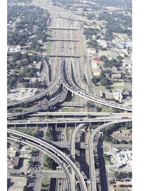
Downtown Freeways 131Critical bottleneck: <strong>The</strong> six-lane Pierce Elevated, named after the street immediately adjacent to it, has become the most criticalbottleneck in the downtown interchange complex. Designed to carry 75,000 vehicles per day, the freeway was serving approximately200,000 vehicles per day in 2003. As this photo shows, large structures alongside the freeway make a major expansionvery difficult. In the foreground is the interchange with <strong>US</strong> <strong>59</strong>. <strong>The</strong> <strong>US</strong> <strong>59</strong> main lanes are depressed below grade and are not visiblein this view. (Photo: May 2002)
<strong>IH</strong> <strong>10</strong> north of downtown: This section of freeway, opened on May 17, 1972, is simple andbasic in comparison to other freeways in the downtown interchange complex. <strong>The</strong> dedicationceremony coincided with the retirement of Albert C. Kyser, head of the TxDOT Houston UrbanProject Office from 1955 to 1972. Kyser and City of Houston Planning Director Ralph Ellifritwere the most influential persons in the design of the downtown interchange complex. (Photo:July 2002)<strong>The</strong> unbuilt: This view shows a section of the final plan for the downtown interchangecomplex, which was approved in 1963. <strong>The</strong> La Porte Freeway, also known as theHarrisburg Freeway for the unbuilt section inside Loop 6<strong>10</strong>, was planned to terminateat <strong>US</strong> <strong>59</strong> near what is now the baseball stadium for the Houston Astros. <strong>The</strong> La PorteFreeway was cancelled in the mid-1970s due to community opposition and fundingshortages. It is the only part of the originally planned downtown interchange complex thatwas not constructed. (Map: HMRC)
Downtown Freeways 133<strong>IH</strong> 45 construction: This view shows the construction of <strong>IH</strong> 45 on the north side of downtownin May 1961 at the location of the multiplex interchange with <strong>IH</strong> <strong>10</strong>. Initially only <strong>IH</strong> 45 was constructedthrough the interchange. This section of freeway parallels White Oak Bayou and followedan ideal freeway corridor due to the limited development. Houston’s 1942 Major Street Planidentified the White Oak Bayou corridor as one of the three best potential alignments for newfreeways. (Photo: TxDOT)
134 Houston FreewaysOne freeway complete, one to come: <strong>The</strong>se views show the <strong>IH</strong> 45-<strong>IH</strong> <strong>10</strong> multiplex interchange prior to the construction of <strong>IH</strong> <strong>10</strong>.<strong>The</strong> wide median and adjacent cleared right-of-way would later become <strong>IH</strong> <strong>10</strong> and its connection ramps. <strong>The</strong> upper photo wastaken just after the freeway opening in July 1962. <strong>The</strong> lower photo was taken in December 1964. (Photos: upper, HMRC MSS157-907; lower, TxDOT)
Downtown Freeways 135Transitways finish the interchange: <strong>The</strong> interchange remains in its original 1968configuration, except for the addition of transitway lanes. <strong>The</strong> elevated transitwayramp for high-occupancy vehicles was opened October 16, 2000. (Photo: September2002)
136 Houston Freeways<strong>US</strong> <strong>59</strong> construction: This view shows construction of the interchange at <strong>US</strong> <strong>59</strong> and <strong>IH</strong> 45in April 1972. <strong>The</strong> <strong>IH</strong> 45 main lanes had previously opened in 1967. (Photo: TxDOT)(Opposite page) Scorched earth turns into freeway: <strong>The</strong>se photos show before and afterviews of the <strong>US</strong> <strong>59</strong>-SH 288 multiplex interchange on the south side of downtown. <strong>The</strong> constructionof this wide freeway required the largest right-of-way clearance in the constructionof the downtown interchange complex. In the upper photo, taken in January 1969, rightof-wayclearance is just about complete. <strong>The</strong> freeway was opened to traffic on September27, 1974. <strong>The</strong> entire interchange was finished in 1980 with the completion of connectionsto the SH 288 South Freeway, shown in the far distance in the lower photo. (Photos: upper,Houston Chronicle; lower, May 2002)
138 Houston FreewaysConstruction of the <strong>US</strong> <strong>59</strong> Buffalo Bayou bridge, November 1957: <strong>The</strong> completion ofthis link on April 11, 1958, brought the Eastex Freeway into downtown Houston. <strong>The</strong> row ofbuildings just to the left of the freeway is the Clayton Homes housing project, which openedMarch 22, 1952. It replaced Schrimpf Alley, which was reportedly the worst slum district inHouston. Land acquisition costs for the Clayton Homes project were paid by Susan V. Clayton,wife of Houston cotton magnate and statesman William L. Clayton. 13 (Photo: TxDOT)
<strong>US</strong> <strong>59</strong> gets its downtown connections: <strong>The</strong>sephotos show the new interchange complex beingconstructed on the Eastex Freeway (<strong>US</strong> <strong>59</strong>North) approach to downtown. Original plans forthe downtown Houston freeway system includeda complete distribution system for each freewaycoming into downtown, but plans for the EastexFreeway were dropped because the Union Stationrail yard blocked the needed feeder streets.In the late 1990s work began to rebuild the<strong>US</strong> <strong>59</strong>-<strong>IH</strong> <strong>10</strong> interchange and add a distributionsystem for the Eastex Freeway.In the upper photo, the original <strong>US</strong> <strong>59</strong> structureis the second from the right and was in the processof being demolished when the photo wastaken in May 2002. In the photo at left, taken inNovember 2002, the original bridge structure hasbeen almost completely demolished—all thatremains are a few piers near the bottom of thephoto. <strong>The</strong> new <strong>US</strong> <strong>59</strong> southbound main laneswere constructed on the location of the demolishedoriginal bridge. <strong>The</strong> project is scheduled forcompletion in 2004.<strong>The</strong> <strong>US</strong> <strong>59</strong> downtown distribution system and accompanyingreconstructed interchange at <strong>IH</strong> <strong>10</strong>is the first new-facility construction in downtownHouston since the original completion of the interchangecomplex in 1980.
140 Houston FreewaysFreeway with a view: <strong>The</strong> elevated structures on <strong>IH</strong> 45 skirting the west and south edges of downtown provide motorists withoutstanding views. When the Pierce Elevated section of <strong>IH</strong> 45 opened in 1967, the Houston Chronicle took note of the impressivedriving experience provided by the elevated freeways: “Not only does it speed the traffic flow, it also affords motorists a magnificentview of the business district. It’s almost like going up in a cable car.” 14 (Photo: May 2003)(Opposite page) Where the freeways come together:Looking north along the <strong>IH</strong> 45-<strong>IH</strong> <strong>10</strong> interchange north ofdowntown. (Photo: November 2002)