Ecuador and the Galapagos Islands - Geodyssey
Ecuador and the Galapagos Islands - Geodyssey
Ecuador and the Galapagos Islands - Geodyssey

You also want an ePaper? Increase the reach of your titles
YUMPU automatically turns print PDFs into web optimized ePapers that Google loves.
<strong>Ecuador</strong> ê GUIDE<br />
Andes<br />
An extraordinary number of high volcanoes,<br />
wonderful scenery, colourful farming<br />
communities, expert weavers <strong>and</strong> crafts<br />
people, historic haciendas, <strong>and</strong> untouched<br />
nature make <strong>Ecuador</strong> <strong>the</strong> epitome of <strong>the</strong><br />
Andean world.<br />
W<br />
onderful scenery is commonplace<br />
almost everywhere you travel in <strong>the</strong><br />
Andes, but <strong>the</strong> central highl<strong>and</strong>s<br />
south of Quito offer some of <strong>the</strong> loveliest<br />
mountain scenery in <strong>the</strong> country. The fertile<br />
valley between <strong>the</strong> main eastern <strong>and</strong> western<br />
sierras has been heavily populated since pre-<br />
Incan times. Large haciendas control <strong>the</strong> best<br />
l<strong>and</strong> on <strong>the</strong> valley floor, while higher slopes<br />
are farmed by Quichua-speaking families who<br />
wring small crops of potatoes <strong>and</strong> maize from<br />
precipitous fields <strong>and</strong> terraces. Their winding<br />
lanes <strong>and</strong> peaceful hamlets, coupled with<br />
immense views, volcanic peaks, beautiful crater<br />
lakes, <strong>and</strong> ‘perpetual spring’ wea<strong>the</strong>r, make<br />
many parts of <strong>the</strong> sierras especially good for<br />
walking <strong>and</strong> trekking.<br />
The Incan Royal Road between Quito <strong>and</strong><br />
Cusco in Peru followed <strong>the</strong> valley’s contours, as<br />
does <strong>the</strong> modern Pan-American Highway <strong>and</strong><br />
<strong>the</strong> old railway line, whose westward branch<br />
plunges down <strong>the</strong> Devil’s Nose towards <strong>the</strong><br />
Pacific.<br />
The Avenue of <strong>the</strong> Volcanoes<br />
In this part of <strong>Ecuador</strong>, <strong>the</strong> Andes are at <strong>the</strong>ir<br />
most volcanic, with over fifty peaks (a good<br />
number of <strong>the</strong>m active) pushing upwards from<br />
<strong>the</strong> colliding tectonic plates below. Alex<strong>and</strong>er<br />
von Humboldt described <strong>the</strong> route south<br />
from Quito to Riobamba as <strong>the</strong> ‘Avenue of <strong>the</strong><br />
Volcanoes’, with <strong>the</strong> peaks of <strong>the</strong> twin sierras<br />
arrayed on ei<strong>the</strong>r side.<br />
Driving south on <strong>the</strong> Pan American Highway<br />
on a fine day gives dramatic views of Pichincha<br />
(4,675m), Atacazo (4,463m), Corazón<br />
(4,788m), Ilinizas (5,248m), Carihuayrazo<br />
(5,028m) <strong>and</strong> Chimborazo (6,310m) in<br />
<strong>the</strong> western chain, while seen to <strong>the</strong> east are<br />
Pasochoa (4,199m), Rumiñahui (4,712m),<br />
Cotopaxi (5,897m), Quilindaña (4,877m),<br />
Tungurahua (5,029m), El Altar (5,319m), <strong>and</strong><br />
Sangay (5,230m). The snow-line is usually<br />
around 5,000m.<br />
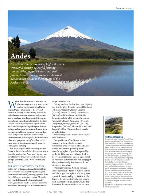
The most impressive of <strong>the</strong>se are Cotopaxi<br />
<strong>and</strong> Chimborazo.<br />
Cotopaxi is one of <strong>the</strong> highest active<br />
volcanoes in <strong>the</strong> world. Its perfectly<br />
symmetrical cone covered in a thick blanket<br />
of snow <strong>and</strong> ice rises gracefully from a<br />
beautiful high plain of grassl<strong>and</strong>s grazed by<br />
herds of wild horses who ga<strong>the</strong>r to drink at<br />
<strong>the</strong> lovely Limpiopungo lagoon–a good spot<br />
for waterfowl <strong>and</strong> o<strong>the</strong>r birds, with <strong>the</strong> jagged<br />
white peaks of nearby Rumiñahui volcano<br />
reflected in its surface.<br />
Walking in Cotopaxi National Park you<br />
will notice volcanic debris of pumice <strong>and</strong> ash<br />
amid <strong>the</strong> tiny páramos plants. On a day trip it<br />
is possible to drive as high as 4,600m on <strong>the</strong><br />
slopes of <strong>the</strong> volcano <strong>the</strong>n hike up a scree to<br />
reach <strong>the</strong> snout of its glacier at 4,800m. The<br />
thinness of <strong>the</strong> air means this short distance<br />
The Incas at Ingapirca<br />
The Incan empire began to exp<strong>and</strong> in Peru in 1438 <strong>and</strong><br />
spread into <strong>Ecuador</strong> through a series of conquests <strong>and</strong><br />
alliances dating from 1516. Less than twenty years later<br />
it had been extinguished by <strong>the</strong> Incan civil war <strong>and</strong> <strong>the</strong><br />
Spanish conquest. In this short space of time it had a<br />
remarkable effect, both culturally in <strong>the</strong> organisation of<br />
society <strong>and</strong> <strong>the</strong> introduction of <strong>the</strong> Quichua language,<br />
<strong>and</strong> physically in terms of roads <strong>and</strong> buildings. The<br />
most important Incan site in <strong>Ecuador</strong> is at Ingapirca,<br />
north of Cuenca. Here a temple complex incorporating<br />
classic Inca stonework with precisely fitted ‘pillow’<br />
blocks is built upon earlier Cañari structures.<br />
Ingapirca lies in a graceful setting on a low hill. At its<br />
centre is a substantially intact temple of <strong>the</strong> sun, with<br />
inwardly tapering walls of supremely well-fitted stone<br />
blocks <strong>and</strong> a trapezoidal doorway, hallmarks of <strong>the</strong><br />
finest Incan construction. Laid out around <strong>the</strong> temple<br />
are <strong>the</strong> low remains of a great plaza, <strong>and</strong> of a good<br />
number of buildings that must have included official<br />
residences, stores, houses, barracks <strong>and</strong> a tambo or inn<br />
for travellers on <strong>the</strong> Royal Road between Quito <strong>and</strong><br />
Cusco in Peru.<br />
The nearby town of Cañar is notable for fine weaving<br />
<strong>and</strong> its busy Sunday market.<br />
GEODYSSEY | ECUADOR T: 020 7281 7788 www.geodyssey.co.uk/ecuador<br />
9