Shelton UGA Plan - Mason County
Shelton UGA Plan - Mason County
Shelton UGA Plan - Mason County
You also want an ePaper? Increase the reach of your titles
YUMPU automatically turns print PDFs into web optimized ePapers that Google loves.
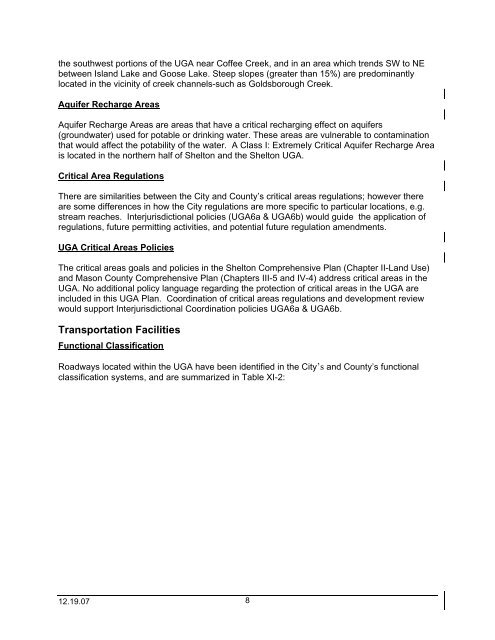
the southwest portions of the <strong>UGA</strong> near Coffee Creek, and in an area which trends SW to NEbetween Island Lake and Goose Lake. Steep slopes (greater than 15%) are predominantlylocated in the vicinity of creek channels-such as Goldsborough Creek.Aquifer Recharge AreasAquifer Recharge Areas are areas that have a critical recharging effect on aquifers(groundwater) used for potable or drinking water. These areas are vulnerable to contaminationthat would affect the potability of the water. A Class I: Extremely Critical Aquifer Recharge Areais located in the northern half of <strong>Shelton</strong> and the <strong>Shelton</strong> <strong>UGA</strong>.Critical Area RegulationsThere are similarities between the City and <strong>County</strong>’s critical areas regulations; however thereare some differences in how the City regulations are more specific to particular locations, e.g.stream reaches. Interjurisdictional policies (<strong>UGA</strong>6a & <strong>UGA</strong>6b) would guide the application ofregulations, future permitting activities, and potential future regulation amendments.<strong>UGA</strong> Critical Areas PoliciesThe critical areas goals and policies in the <strong>Shelton</strong> Comprehensive <strong>Plan</strong> (Chapter II-Land Use)and <strong>Mason</strong> <strong>County</strong> Comprehensive <strong>Plan</strong> (Chapters III-5 and IV-4) address critical areas in the<strong>UGA</strong>. No additional policy language regarding the protection of critical areas in the <strong>UGA</strong> areincluded in this <strong>UGA</strong> <strong>Plan</strong>. Coordination of critical areas regulations and development reviewwould support Interjurisdictional Coordination policies <strong>UGA</strong>6a & <strong>UGA</strong>6b.Transportation FacilitiesFunctional ClassificationRoadways located within the <strong>UGA</strong> have been identified in the City’s and <strong>County</strong>’s functionalclassification systems, and are summarized in Table XI-2:12.19.07 8


