2012 MASON COUNTY TAX FORECLOSURE MINIMUM BID SHEET
2012 MASON COUNTY TAX FORECLOSURE MINIMUM BID SHEET
2012 MASON COUNTY TAX FORECLOSURE MINIMUM BID SHEET
You also want an ePaper? Increase the reach of your titles
YUMPU automatically turns print PDFs into web optimized ePapers that Google loves.
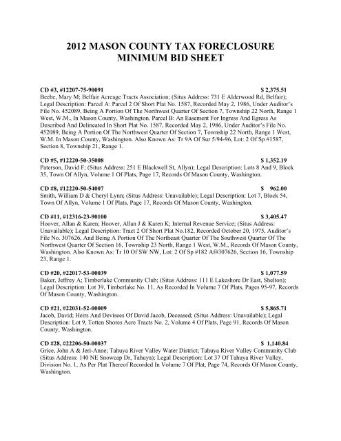
<strong>2012</strong> <strong>MASON</strong> <strong>COUNTY</strong> <strong>TAX</strong> <strong>FORECLOSURE</strong><strong>MINIMUM</strong> <strong>BID</strong> <strong>SHEET</strong>CD #3, #12207-75-90091 $ 2,375.51Beebe, Mary M; Belfair Acreage Tracts Association; (Situs Address: 731 E Alderwood Rd, Belfair);Legal Description: Parcel A: Parcel 2 Of Short Plat No. 1587, Recorded May 2, 1986, Under Auditor’sFile No. 452089, Being A Portion Of The Northwest Quarter Of Section 7, Township 22 North, Range 1West, W.M., In Mason County, Washington. Parcel B: An Easement For Ingress And Egress AsDescribed And Delineated In Short Plat No. 1587, Recorded May 2, 1986, Under Auditor’s File No.452089, Being A Portion Of The Northwest Quarter Of Section 7, Township 22 North, Range 1 West,W.M. In Mason County, Washington. Also Known As: Tr 9A Of Sur 5/94-96, Lot: 2 Of Sp #1587,Section 8, Township 21, Range 1.CD #5, #12220-50-35008 $ 1,352.19Paterson, David F; (Situs Address: 251 E Blackwell St, Allyn); Legal Description: Lots 8 And 9, Block35, Town Of Allyn, Volume 1 Of Plats, Page 17, Records Of Mason County, Washington.CD #8, #12220-50-54007 $ 962.00Smith, William D & Cheryl Lynn; (Situs Address: Unavailable); Legal Description: Lot 7, Block 54,Town Of Allyn, Volume 1 Of Plats, Page 17, Records Of Mason County, Washington.CD #11, #12316-23-90100 $ 3,405.47Hoover, Allan & Karen; Hoover, Allan J & Karen K; Internal Revenue Service; (Situs Address:Unavailable); Legal Description: Tract 2 Of Short Plat No.182, Recorded October 20, 1975, Auditor’sFile No. 307626, And Being A Portion Of The Northeast Quarter Of The Southwest Quarter Of TheNorthwest Quarter Of Section 16, Township 23 North, Range 1 West, W.M., Records Of Mason County,Washington. Also Known As: Tr 10 Of SW NW, Lot: 2 Of Sp #182 Af#307626, Section 16, Township23, Range 1.CD #20, #22017-53-00039 $ 1,077.59Baker, Jeffrey A; Timberlake Community Club; (Situs Address: 111 E Lakeshore Dr East, Shelton);Legal Description: Lot 39, Timberlake No. 11, As Recorded In Volume 7 Of Plats, Pages 95-97, RecordsOf Mason County, Washington.CD #21, #22031-52-00009 $ 5,865.71Jacob, David; Heirs And Devisees Of David Jacob, Deceased; (Situs Address: Unavailable); LegalDescription: Lot 9, Totten Shores Acre Tracts No. 2, Volume 4 Of Plats, Page 91, Records Of MasonCounty, Washington.CD #28, #22206-50-00037 $ 1,140.84Grice, John A & Jeri-Anne; Tahuya River Valley Water District; Tahuya River Valley Community Club(Situs Address: 140 NE Snowcap Dr, Tahuya); Legal Description: Lot 37 Of Tahuya River Valley,Division No. 1, As Per Plat Thereof Recorded In Volume 7 Of Plat, Page 74, Records Of Mason County,Washington.
CD #34, #22223-75-00130 $ 3,480.51Noven, Kazem; Baumgartner, David L & Linda L; Decabooter Revocable Living Trust And Sonora,LLC; (Situs Address: Unavailable); Legal Description: Parcel A: Tract 13 Of Survey Recorded June 9,1989 In Volume 14 Of Surveys Page 6, Under Auditors File No. 494737 And Being A Portion Of TheSouthwest Quarter Of Section 23, Township 22 North, Range 2 West, W.M., In Mason County,Washington. Parcel B: A Non-Exclusive Easement For Ingress And Egress As Described And DelineatedOn Survey Recorded June 9 1989 In Volume 14 Of Surveys, Page 6 Under Auditor’s File No. 494737,Being A Portion Of The Southwest Quarter, Section 23, Township 22 North, Range 2 West, W.M., InMason County, Washington. Also Known As: Tr 13 Of Survey 14/6, Section 23, Township 22, Range 2.CD #39, #32016-50-00018 $ 1,520.13Smith, Andrea L; Smith, Andrea Lisa; (Situs Address: Unavailable); Legal Description: All That PortionOf Government Lot 5, Section 16, Township 20 North, Range 3 West, W.M., Records Of Mason County,Washington, Particularly Described As Follows: Beginning At A Point South 48° West, 1310 Feet FromA Point On The West Line Of Government Lot 4 Of Said Section 16, 250 Feet Northerly Of ItsSouthwest Corner; Thence South 48° West, 75 Feet; Thence North 42° West To The Line Of OrdinaryHigh Tide Of Hammersley Inlet; Thence Northeasterly, Along Said Line Of Ordinary High Tide, To APoint North 42° West Of The Point Of Beginning Of This Description; Thence South 42° East To SaidPoint Of Beginning. Said Land Also Known And Described As The North Half Of Tract 18 Of TheUnrecorded Plat Of Angle Tracts.CD #40, #32016-50-00901 $ 1,520.13Smith, Andrea L; Smith, Andrea Lisa; (Situs Address: Unavailable); Legal Description: TheSouthwesterly One Half Of A Tract Of Land In Government Lot 5, Section 16, Township 20 North,Range 3 West, W.M., Records Of Mason County, Washington, Particularly Described As Follows:Commencing At The Southeast Corner Of Said Section 16; Thence North (Var. 24°30’ East), Along TheSection Line Between Sections 15 And 16, 1320 Feet, More Or Less, To The Southeast Corner OfGovernment Lot 4; Thence West, Along The South Line Of Said Government Lot 4, 1320 Feet, More OrLess, To The Southwest Corner Thereof; Thence North (Var. 24°30 East), Along The West Line Of SaidGovernment Lot 4, 250 Feet; Thence South 48° West 1310 Feet; Thence North 42° West 252 Feet, MoreOr Less, To The Westerly Line Of Government Lot 5 On The East Side Of Hammersley Inlet, And ThePoint Of Beginning Of The Tract Of Land Hereby Described; Thence South 42° East 252 Feet; ThenceSouth 48° West 150 Feet; Thence North 42° West 279 Feet, More Or Less, To The Westerly Line Of SaidGovernment Lot 5; Thence North 58° East Along The Westerly Line Of Said Government Lot 5, 153Feet, More Or Less, To The Point Of Beginning. Said Land Also Known And Described As TheSouthwesterly Half Of Tract 18 Of The Unrecorded Plat Of Angle Tracts.CD #41, #32016-53-04024 $ 1,294.31Gibbs, Carl W & Laura L; Shorecrest Estates Water Company; Shorecrest Estates Beach Club; (SitusAddress: Unavailable); Legal Description: Lot 24, Block 4, Shorecrest Terrace Fourth Addition,Volum3e6 Of Plats, Pages 129, 130, And 131, Records Of Mason County, Washington.
CD #42, #32019-41-00320 $ 2,802.92L & C Dynasty Limited Partnership; (Situs Address: Unavailable); Legal Description: The North 40 FeetOf The East 125 Feet Of The Following Described Tract Of Land: Beginning At The Southeast Corner OfBlock C Of Needham And Day’s First Addition To Shelton, Washington; Run South On The East LineOf Said Addition To The Southwest Corner Of The Northeast Quarter Of The Southeast Quarter OfSection 19, Township 20 North, Range 3 West, W.M.; Thence East On The South Line Of Said NortheastQuarter Of The Southeast Quarter To The Right Of Way Of The County Road; Thence Following SaidRight Of Way In A Northeasterly Direction To A Point On What Would Be The West Line Of First StreetOf The Town Of Shelton Extended; Thence North 7°30’ East Along Said West Line Of First StreetExtended To Land Formerly Owned By Henrietta Richardson; Thence In A Westerly Direction To ThePoint Of Beginning, Containing 4 Acres, More Or Less, And Being In The Northeast Quarter Of TheSoutheast Quarter Of Section 19, Township 20 North, Range 3 West, W.M., Reserving, However, A StripOf Land 12 Feet In Width On The East Side Of Said Land For Road Purposes. Also, Beginning At TheSoutheast Corner Of Block C Of Needham And Day’s Addition To Shelton, Washington; Run ThenceSouth 86°15’ East 259.40 Feet To The Initial Point Of This Description; From Said Initial Point RunSouth 86°15’ East 67 Feet, More Or Less, To Land Conveyed To William M. Duffey By Deed RecordedIn Volume 49 Of Deeds, At Page 531, Records Of Mason County, Washington; Thence North 7°30’ East83 Feet; Thence North 82°30’ West 10 Feet; Thence Southwesterly 106 Feet, More Or Less, To TheInitial Point, Containing .083 Acres, More Or Less, And Being In The Northeast Quarter Of TheSoutheast Quarter Of Section 19, Township 20 North, Range 3 West, W.M., The North 6 Feet BeingReserved For Alley Purposes. Also Known As: Tract 32 Of NE 1/4 SE 1/4 Of Section 19, Township 20North, Range 3 West, W.M.CD #44, #32019-56-24008 $ 8,493.99Harder, Jean & Clifford H Jr Et Al; Stephen E Harder; (Situs Address: Unavailable); Legal Description:Lots 1, 2, 3 And 4, Of Fractional Block E, Needham And Day’s Addition To Shelton, Volume 1 Of Plats,Page 27, Records Of Mason County, Washington.CD #49, #32021-54-02001 $ 1,538.87Smith, Andrea L; Smith, Andrea Lisa; Shorecrest Estates Water Company; Shorecrest Beach Club; (SitusAddress: 2291 E Crestview Dr, Shelton); Legal Description: Lot 1, Block 2, Plat Of Shorecrest TerraceFirst Addition, Volume 5 Of Plats, Page 73, Records Of Mason County, Washington.CD #50 #32021-55-02029 & 30 07162 $ 2,412.32Heirs At Law Of Harold E Coon, Who Acquired Title As Harold E Coons, Deceased; Leona M Coon,Who Acquired Title As Leona M Coons; Heirs & Devisees Of Leona M Coon, Deceased; State ofWashington Department of Financial Recovery; Shorecrest Estates Water Company; Shorecrest BeachClub; (Situs Address: 20 E Hammond Pl, Shelton); Legal Description: Lot 29 In Block 2 Of ShorecrestTerrace Second Addition, As Recorded In Volume 5 Of Plats, Page(S) 83, In Mason County,Washington. Including A 1967 Buddy Mobile Home, 12’ X 52’, Vin# Unknown.CD #51, #32021-56-01012 $ 1,631.75McCart, Michael J; Mason County Sheriff’s Office; Shorecrest Beach Club; Shorecrest Estates WaterCompany; (Situs Address: 150 Panorama Drive, Shelton); Legal Description: Lot 12, Block 1, ShorecrestTerrace, Third Addition, According To The Recorded Plat Therein In Volume 5 Of Plats, Pages 92 And93, Mason County, Washington.CD #52, #32021-56-01019 $ 1,686.30Johnson, Walter & Debbi; Vision Corporation; Shorecrest Estates Water Company; Shorecrest BeachClub; (Situs Address: 240 E Panorama Dr, Shelton); Legal Description: Lot 19, Block 1, Plat Of
Turla, Aurora A Trustee Of The Jose S Turla Credit Trust Et Al; Forentino & Irene Tanedo; James A &Shirley Brix; Heirs And Devisees Of The Estate Of James A Brix, Deceased; (Situs Address:Unavailable); Legal Description: Parcel A: Lot 1 Of Mason County Short Plat 595(R), Recorded October22, 1981, Under Recording No. 396848, And Being A Portion Of The Southeast Quarter Of Section 34,Township 21 North, Range 3 West, W.M., In Mason County, Washington. Parcel B: A Non-ExclusiveEasement For Ingress And Egress As Disclosed By Mason County Short Plat 595(R), Recorded October22, 1981, Under Recording No. 396848.CD#70, #32214-52-02005 $ 1,547.64Laney, Elmer P & Annette M; Heirs And Devisees Of Elmer P Laney, Deceased; Heirs And Devisees OfAnnette M Laney, Deceased; Laurence P Gill, As Trustee Of The Estate Of L Presley Gill, Deceased,King County Cause #87-4-03234-2 And Vera C Gill, As Her Separate Estate; Maggie Lake Water District#3, Maggie Lake Community Club; Maggie Lake Maintenance Corp.; (Situs Address: 20 NE MagnoliaPlace, Tahuya); Legal Description: Lot 5, Block 2, Plat Of Maggie Lake No. 3, Volume 5 Of Plats, Pages55 And 56, Records Of Mason County, Washington.CD#72, #32219-50-00052 $ 3,080.82Jones-Blair, Carol Et Al; Kelly M Hollis; (Situs Address: Unavailable); Legal Description: Tract 19 OfSportsmen Waterfront Tracts, Volume 4 Of Plats, Page 14, Records Of Mason County, Washington;Excepting Therefrom The East 300 Feet. Together With All Tidelands Conveyed By The State OfWashington Lying In Front Of, Adjacent To And Abutting On Said Tract.CD#77, #32224-50-00060 $ 816.38Fink, John D & V Jane; (Situs Address: Unavailable); Legal Description: That Portion Of Tract 70, PlatOf Cadys Sunrise Beach, According To The Plat Recorded In Volume 4 Of Plats, Page 8, In MasonCounty, Washington, Lying Northwesterly Of County Road.CD#78, #32232-50-10102 $ 1,362.98Pacific Coast Investment Company; Pacific Coast Investment Company, As Investment Manager For TheInvestors As Listed: Don C. Burlingame And Joyce A. Burlingame As To 5.27% Charles H. BillingtonAnd Dorothy D. Billington As To 4.39% Nicholas L. Nelson As To 1.76% Joseph L. Lambert And IreneE. Lambert, Trustee Of The Joseph L. Lambert Family Trust U/T/A January 24, 1992 As To 2.55% TheOlerich Family Revocable Living Trust, Vincent E. Olerich And Delda V. Olerich, Trustees As To 1.76%J. Antonio Garcia, M.D. P.S. Profit Sharing Plan & Trust As To 4.39% Susanne Hensinger As To 1.41%Charles R. Baldwin And Dorothy H. Baldwin As To 4.80% Austin J. Kimbrough And Joy E. KimbroughAs To L.32% William F. Graves And Alberta F. Graves As To 1.76% Continental Investments, LLC,T.R. Hazzelrigg, IV, Manager As To 7.69% Myer Coval As To 17.71% H James Zevenbergen As To4.40% Stephen Levey As To 1.76% Lorraine Samuelson As To 4.39% John Harris And Ruth W. HarrisAs To 0.897% Raymond L. Kronquist And Lisa D. King As To 1.76% Kurt Steinbrecher And Rosalie S.Steinbrecher As To 4.666% F & N Partnership, Freidman And Nudelman As To 4.40% Daniel S.Nudelman And Miriam L. Nudelman As To L.80% Bashaw Family Trust, D.R. Bashaw Trustee As To2.367% Helen M. Gee As To 3.51% Revella C. Storer And Jack L. Storer, Trustees, Jack L. & Revella C.Storer Revocable Living Trust As To 1.59% The Walter H. Bergman Testamentary Trust As To 7.00%Dan K. Gallagher And Andrea S. Gallagher As To 3.325% Helen M. Gee As To 3.325%; Interest Of IfAny, Coval, Myer L; (Situs Address: Unavailable); Legal Description: Lot Two (2), And All Of LotThree (3), Excepting The East Half Of The North 40 Feet Of Said Lot Three (3); All In Block OneHundred One (101), Hoods Canal Land And Improvement Co.’s Plan Of Union City, Volume 1 Of Plats,Pages 8 And 9, Record Of Mason County, Washington.CD#79, #32232-50-10105, #30-05279 $ 6,093.41
Pacific Coast Investment Company; Pacific Coast Investment Company, as Investment Manager for theInvestors as listed: Don C. Burlingame and Joyce A. Burlingame as to 5.27% Charles H. Billington andDorothy D. Billington as to 4.39% Nicholas L. Nelson as to 1.76% Joseph L. Lambert and Irene E.Lambert, Trustee of the Joseph L. Lambert Family Trust U/T/A January 24, 1992 as to 2.55% TheOlerich Family Revocable Living Trust, Vincent E. Olerich and DElda V. Olerich, Trustees as to 1.76% J.Antonio Garcia, M.D. P.S. Profit Sharing Plan & Trust as to 4.39% Susanne Hensinger as to 1.41%Charles R. Baldwin and Dorothy H. Baldwin as to 4.80% Austin J. Kimbrough and Joy E. Kimbrough asto l.32% William F. Graves and Alberta F. Graves as to 1.76% Continental Investments, LLC, T.R.Hazzelrigg, IV, Manager as to 7.69% Myer Coval as to 17.71% H James Zevenbergen as to 4.40%Stephen Levey as to 1.76% Lorraine Samuelson as to 4.39% John Harris and Ruth W. Harris as to0.897% Raymond L. Kronquist and Lisa D. King as to 1.76% Kurt Steinbrecher and Rosalie S.Steinbrecher as to 4.666% F & N Partnership, Freidman and Nudelman as to 4.40% Daniel S. Nudelmanand Miriam L. Nudelman as to l.80% Bashaw Family Trust, D.R. Bashaw Trustee as to 2.367% Helen M.Gee as to 3.51% Revella C. Storer and Jack L. Storer, Trustees, Jack L. & Revella C. Storer RevocableLiving Trust as to 1.59% The Walter H. Bergman Testamentary Trust as to 7.00% Dan K. Gallagher andAndrea S. Gallagher as to 3.325% Helen M. Gee as to 3.325%; Interest of If any, Coval, Myer L; (SitusAddress:400 E Orre Nobles Rd, Union); Legal Description: Lot Five (5), Except The West 10 FeetThereof, All Of Lot Six (6), Seven (7) And Eight (8), The West Half Of Lot Nine (9), And The East 20Feet Of The North 40 Feet Of Lot Nine (9); All In Block 101, Plat Of Hood’s Canal Land AndImprovement Co.’s Plan Of Union City, Volume 1 Of Plats, Pages 8 And 9, Records Of Mason County,Washington. Including A 1983 Fleetwood Mobile Home Being 60’ X 14’ In Size, Vin #Orflad34482281,TPO #+02223, Located On The Premises. Also Known As: Union Hood Canal Land & Imp Co, Blk: 101,Lot: 5 E 30’ Lots 6-8, Lot 9 W ½ & E 20’ Of N 40’.75°31’53 West 16.92 Feet; Thence South 14°28’07” West, 4.15 Feet; Thence South 89°18’45” East,17.43 Feet, To The Point Of Beginning. Also Known As: Union Hood Canal Land & Imp Co, Blk: 101 E½ Of S 60’ Lot: 9, Lots: 10-14 Ex Ptn Of 13, Lots: 15-17 Wly Of Hwy 106.Block One Hundred One (101) Which Lies Within A Tract Of Land Particularly Described As Follows:Commencing At The Northeast Corner Of Lot Eighteen (18) Of Said Block One Hundred One (101);Thence North 89°18’45” West, 94.02 Feet, To The Point Of Beginning Of The Tract Of Land HerebyDescribed, Said Point Of Beginning Being North 89°18’45” West, 2.36 Feet From The Southeast CornerOf Lot 13 Of Said Block 101; Thence North 75°31’53” West, 16.92 Feet; Thence South, 14°28’07” West4.15 Feet; Thence South 89°18’45” East, 17.43 Feet, To The Point Of Beginning. Also Known As: UnionHood Canal Land & Imp Co, Blk: 101, Lots 22 Thru 25, 18 Thru 21 W Of Hwy 7 Ptn Vac Allyn Ave Adj&.
CD#84, #32232-50-92901 $ 1,128.12Pacific Coast Investment Company; Pacific Coast Investment Company, as Investment Manager for theInvestors as listed: Don C. Burlingame and Joyce A. Burlingame as to 5.27% Charles H. Billington andDorothy D. Billington as to 4.39% Nicholas L. Nelson as to 1.76% Joseph L. Lambert and Irene E.Lambert, Trustee of the Joseph L. Lambert Family Trust U/T/A January 24, 1992 as to 2.55% TheOlerich Family Revocable Living Trust, Vincent E. Olerich and DElda V. Olerich, Trustees as to 1.76% J.Antonio Garcia, M.D. P.S. Profit Sharing Plan & Trust as to 4.39% Susanne Hensinger as to 1.41%Charles R. Baldwin and Dorothy H. Baldwin as to 4.80% Austin J. Kimbrough and Joy E. Kimbrough asto l.32% William F. Graves and Alberta F. Graves as to 1.76% Continental Investments, LLC, T.R.Hazzelrigg, IV, Manager as to 7.69% Myer Coval as to 17.71% H James Zevenbergen as to 4.40%Stephen Levey as to 1.76% Lorraine Samuelson as to 4.39% John Harris and Ruth W. Harris as to0.897% Raymond L. Kronquist and Lisa D. King as to 1.76% Kurt Steinbrecher and Rosalie S.Steinbrecher as to 4.666% F & N Partnership, Freidman and Nudelman as to 4.40% Daniel S. Nudelmanand Miriam L. Nudelman as to l.80% Bashaw Family Trust, D.R. Bashaw Trustee as to 2.367% Helen M.Gee as to 3.51% Revella C. Storer and Jack L. Storer, Trustees, Jack L. & Revella C. Storer RevocableLiving Trust as to 1.59% The Walter H. Bergman Testamentary Trust as to 7.00% Dan K. Gallagher andAndrea S. Gallagher as to 3.325% Helen M. Gee as to 3.325%; Interest of If any, Coval, Myer L; (SitusAddress: Unavailable); Legal Description: The North Half Of Vacated Allyn Avenue Adjoining Lots 16To 30, Inclusive, Block 92, Hoods Canal Land And Improvement Co.'s Plan Of Union City, Volume 1 OfPlats, Pages 8 And 9, Records Of Mason County, Washington.CD#85, #32232-50-92902 $ 1,128.12Pacific Coast Investment Company; Pacific Coast Investment Company, as Investment Manager for theInvestors as listed: Don C. Burlingame and Joyce A. Burlingame as to 5.27% Charles H. Billington andDorothy D. Billington as to 4.39% Nicholas L. Nelson as to 1.76% Joseph L. Lambert and Irene E.Lambert, Trustee of the Joseph L. Lambert Family Trust U/T/A January 24, 1992 as to 2.55% TheOlerich Family Revocable Living Trust, Vincent E. Olerich and DElda V. Olerich, Trustees as to 1.76% J.Antonio Garcia, M.D. P.S. Profit Sharing Plan & Trust as to 4.39% Susanne Hensinger as to 1.41%Charles R. Baldwin and Dorothy H. Baldwin as to 4.80% Austin J. Kimbrough and Joy E. Kimbrough asto l.32% William F. Graves and Alberta F. Graves as to 1.76% Continental Investments, LLC, T.R.Hazzelrigg, IV, Manager as to 7.69% Myer Coval as to 17.71% H James Zevenbergen as to 4.40%Stephen Levey as to 1.76% Lorraine Samuelson as to 4.39% John Harris and Ruth W. Harris as to0.897% Raymond L. Kronquist and Lisa D. King as to 1.76% Kurt Steinbrecher and Rosalie S.Steinbrecher as to 4.666% F & N Partnership, Freidman and Nudelman as to 4.40% Daniel S. Nudelmanand Miriam L. Nudelman as to l.80% Bashaw Family Trust, D.R. Bashaw Trustee as to 2.367% Helen M.Gee as to 3.51% Revella C. Storer and Jack L. Storer, Trustees, Jack L. & Revella C. Storer RevocableLiving Trust as to 1.59% The Walter H. Bergman Testamentary Trust as to 7.00% Dan K. Gallagher andAndrea S. Gallagher as to 3.325% Helen M. Gee as to 3.325%; Interest of If any, Coval, Myer L; (SitusAddress: 390 E Orre Nobles Rd, Union); Legal Description: The South Half Of Vacated Pontius AvenueAdjoining Lots 1 To 15, Inclusive, Block 92, Hood’s Canal Land And Improvement Co.’s Plan Of UnionCity, Volume 1 Of Plats, Pages 8 And 9, Records Of Mason County, Washington.CD#86, #32309-50-01038 $ 1,274.63Purcell, Antone E & Patricia R; Colony Surf Club, Inc.; (Situs Address: 110 N Colony Surf Dr,Lilliwaup); Legal Description: Lot 38, Block 1, Colony Surf No. 1, Volume 6 Of Plats, Pages 93 And94, Records Of Mason County, Washington.
CD#89, #42013-51-01004 $ 8,049.57Bolster, Maria; Heirs and Devisees of Maria M Bolster, Deceased, Lorraine Dixon PersonalRepresentative; Washington State Department of Social and Health Services, Office of FinancialRecovery; (Situs Address: 1711 Adams St, Shelton); Legal Description: Lot 4 In Block 1 Of MountainView Addition Second Extension, As Recorded In Volume 4 Of Plats, Page(S) 47, In Mason County,Washington.CD#90, #42021-32-00040 & #30-10246 $ 11,518.55Rodgers, Louis D & Billie L; Heirs and Devisees of Louis Rodgers, Deceased; Heirs and Devisees ofBillie Rodgers, Deceased; (Situs Address: Unavailable); Legal Description: Parcel A: The South One-Half Of The Southeast Quarter Of The Northwest Quarter Of The Southwest Quarter In Section 21,Township 20 North, Range 4 West, W.M., In Mason County, Washington. Parcel B: Together With AndSubject To A Perpetual Nonexclusive Easement 60 Feet In Width, For Road Purposes, Over And AcrossThe Following Land, To Wit: The North 30 Feet Of The Southwest Quarter Of The Southwest Quarter;The South 30 Feet Of The Northwest Quarter Of The Southwest Quarter; All That Portion Of The East 30Feet Of The Northwest Quarter Of The Southwest Quarter, Lying Southerly Of An Existing Roadway;All That Portion Of The West 30 Feet Of The Northeast Quarter Of The Southwest Quarter LyingSoutherly Of An Existing Roadway; And Over And Across Said Existing Roadway From The WestLine Of The Northeast Quarter Of The Southwest Quarter In A Northeasterly Direction To AnIntersection With The North Line Of Said Northeast Quarter, Of Southwest Quarter; All In Section 21,Township 20 North, Range 4 West, W.M., In Mason County, Washington. Including A 1994Lamplighter Mobile Home, 27’ X 66’, TPO #1854650-D. Also Known As: Tr 4 Of NW ¼ SW ¼Section 21, Township 20, Range 4.CD#91, #42110-41-00011 $ 1,427.46Weber, Katherina Et Al; Phillip Weber; Heirs and Devisees of Alexander Weber, Deceased, KatharinaMarquerite Weber, Personal Representative; (Situs Address: Unavailable); Legal Description: That PartOf The Northeast Quarter Of The Southeast Quarter Of Section 10, Township 21 North, Range 4 West,W.M., Described As Follows: Beginning At A Point 1462.2 Feet North Of The Southwest Corner Of TheEast Half Of Said Southeast Quarter; Running Thence North 449.4 Feet; Thence East 420 Feet More OrLess To The Westerly Line Of U.S. Route No. 101: Thence SoutherlyAlong Said Westerly Line Of Highway 530 Feet More Or Less To A Point East Of The Point OfBeginning Of This Description; Thence West 150 Feet More Or Less To Said Point Of Beginning. SituateIn Mason County, Washington. Also Known As: Tr 1A Of SE, Section 10, Township 21, Range 4.CD#93, #42204-50-00111 & 50-01900 $ 2,840.31Bennett, James F & Judy A; Heirs and Devisees of James F and Judy A Bennett, Deceased; Cindy MLarsen, Personal Representative; City of Tacoma; Lake Cushman Company, A WA Corp; Lake CushmanMaintenance Company; (Situs Address: Unavailable); Legal Description: A Leasehold Interest In: Lot111, Plat Of Lake Cushman No. 5, As Recorded In Volume 6 Of Plats, Pages 174-177, Inclusive, RecordsOf Mason County, Washington.CD#94, #42204-50-00112 & #50-00450 $ 4,986.11Larsen, Cindy M Et Al; Thomas P Bennett & Cindy M Larsen Custodian for Zachary J Larson, A MinorUnder The Uniform Gift To Minors Act; KeyBank National Association; City of Tacoma; Lake CushmanCompany, A WA Corp; Lake Cushman Maintenance Company; (Situs Address: 330 N Mt Juniper Dr,Hoodsport): Legal Description: A Leasehold Interest In: Lot One Hundred Twelve (112), Plat Of LakeCushman No. 5, As Recorded In Volume 6 Of Plats, Pages 174-177, Inclusive, Records Of MasonCounty.
CD#96, #42205-51-01087 $ 1,431.97Umpstead, Thomas R; City of Tacoma; Lake Cushman Company, A WA Corp; Lake CushmanMaintenance Company; (Situs Address: 120 N Mallard Way W, Hoodsport); Legal Description: ALeasehold Interest In: Lot 87, Block 1 Of Lake Cushman No. 18, As Recorded In Volume 10 Of Plats,Page(S) 41 To 50, Inclusive, Records Of Mason County, Washington.CD#97, #42205-51-02020 & #50-09356 $ 1,548.20Manning, Robert W; City of Tacoma; Lake Cushman Company, A WA Corp; Lake CushmanMaintenance Company; (Situs Address: 41 N Golden eye Place, Hoodsport); Legal Description: ALeasehold Interest In: Lot 20 In Block 2 Of Lake Cushman Number 18, As Recorded In Volume 10 OfPlats, Page(S) 41 To 50, In Mason County, Washington.CD #99, #42216-53-00031 & #50-01368 $ 2,535.84Greeley, Holden D; Greeley, Holden; Interest of if any: Dianne Marie Greeley; City of Tacoma; LakeCushman Company, A WA Corp; Lake Cushman Maintenance Company; (Situs Address: 70 N BassPlace, Hoodsport); Legal Description: A Leasehold Interest In: Lots 31 And 32, Lake Cushman No. 16,Volume 9 Of Plats, Pages 73 To 77, Inclusive, Records Of Mason County, Washington.CD#100, #42333-51-0<strong>2012</strong> & #50-09377 $ 1,695.98Greeley, Holden D & Dianne M; Dianne Marie Greeley; City of Tacoma; Lake Cushman Company, AWA Corp; Lake Cushman Maintenance Company; (Situs Address: Unavailable); Legal Description: ALeasehold Interest In: Parcel A: Lot 12, Block 2, Lake Cushman Eastside No. 1, Volume 9 Of Plats,Pages 110 To 126, Inclusive, Records Of Mason County, Washington. Parcel B: Together With AnEasement For Ingress And Egress As Described In Document Recorded May 25, 1988, Auditor’s File No.481216 And Rerecorded April 10, 1990, Auditor’s File No. 507066.CD#101, #42333-51-02013 $ 1,695.98Greeley, Holden D & Dianne M; Dianne Marie Greeley; City of Tacoma; Lake Cushman Company, AWA Corp; Lake Cushman Maintenance Company; (Situs Address: Unavailable); Legal Description: ALeasehold Interest In: Parcel A: Lot 13, Block 2, Lake Cushman Eastside No. 1, Volume 9 Of Plats,Pages 110 To 126, Inclusive, Records Of Mason County, Washington. Parcel B: Together With AnEasement For Ingress And Egress As Described In Document Recorded May 25, 1988, Auditor’s File No.481216 And Rerecorded April 10, 1990, Auditor’s File No. 507066.CD#102, #42333-51-03001 $ 1,695.98Greeley, Holden D & Dianne M; Dianne Marie Greeley; Interest of if any: Jacqulyn A Miller; Interest ofif any: James G O’Neil and Joan B O’Neil; City of Tacoma; Lake Cushman Company, A WA Corp; LakeCushman Maintenance Company; (Situs Address: Unavailable); Legal Description: A Leasehold InterestIn: Parcel A: Lot 1, Block 3, Lake Cushman Eastside No. 1, Volume 9 Of Plats, Pages 110 To 126,Inclusive, Records Of Mason County, Washington. Parcel B: Together With An Easement For IngressAnd Egress As Described In Document Recorded May 25, 1988, Auditor’s File No. 481216 AndRerecorded April 10, 1990, Auditor’s File No. 507066.CD#103, #42333-51-03002 $ 1,695.98Greeley, Holden D; Interest of if any: Dianne Marie Greeley; City of Tacoma; Lake Cushman Company,A WA Corp; Lake Cushman Maintenance Company; (Situs Address: Unavailable); Legal Description: ALeasehold Interest In: Parcel A: Lot 2, Block 3, Lake Cushman Eastside No. 1, Volume 9 Of Plats, Pages110 To 126, Inclusive, Records Of Mason County, Washington. Parcel B: Together With An EasementFor Ingress And Egress As Described In Document Recorded May 25, 1988, Auditor’s File No. 481216And Rerecorded April 10, 1990, Auditor’s File No. 507066.
CD#104, #42333-51-06045 $ 1,542.99Peabody, Lamont K & Corinne H; Lake Cushman Maintenance Company; City of Tacoma; LakeCushman Company, A WA Corp; (Situs Address: 661 N Hill Top Loop Rd. Hoodsport); LegalDescription: A Leasehold Interest In: Lot 45, Block 6, Lake Cushman Eastside No. 1, Volume 9 Of Plats,Pages 110 To 126, Inclusive, Records Of Mason County, Washington.CD#105, #51908-50-00051 $ 1,040.38McStay, Judith; Star Lake Community Club; (Situs Address: Unavailable); Legal Description: Lot 51 OfStar Lake No. 1, As Recorded In Volume 5 Of Plats, Page 103, Records Of Mason County, Washington.CD#106, #51917-52-00102 $ 5,672.71Randles, Timothy L & Maureen J; Mason County Public Health- Environmental Health; Lake ArrowheadCommunity Club; (Situs Address: 40 W Colville Trail, Elma); Legal Description: Lot 102, LakeArrowhead Division No. 3, Volume 6 Of Plats, Pages 138 And 139, Records Of Mason County,Washington.CD#107, #51917-53-00001 $ 1,115.92Estate of Chuck Smith; The Heirs and Devisees of Chuck Smith, also known as Charles Lee Smith andJohn Sebastian Folk Jr., Deceased; Lake Arrowhead Community Club; (Situs Address: 940 W SatsopCloquallam Rd, Elma); Legal Description: Lot 1, Lake Arrowhead Division No. 4, As Recorded InVolume 6 Of Plats, Page 178 And 179, Both Inclusive, Records Of Mason County, Washington.CD#109, #52001-77-90142 $ 2,353.98Simpson, Lon E; Washington State Department of Social and Health Services, Office of FinancialRecovery; FIA Card Services, N.A.; (Situs Address: 291 W Simpson Rd, Shelton); Legal Description:Lot 2 Of Short Subdivision No. 1524, Recorded May 23, 1985, Auditor’s File No. 440499, And Being APortion Of The East Half Of The Southwest Quarter Of Section 1, Township 20 North, Range 5 West,W.M., In Mason County, Washington. Also Known As: Tr 14-B Of Surv 6/41 Tr 2 Of Sp#1524,#440499, Section 1, Township 20, Range 5.CD#111, #61902-51-00053 $ 1,040.50Diem, Michael & Jennifer E; Ripplewood Utilities; (Situs Address: 120 W Huckleberry Court, Elma);Legal Description: Lot 53, Ripplewood Tracts Replat; Volume 8 of Plats, Pages 55, 56 and 57, RecordsOf Mason County, Washington.


