Province of Puno - South American Destination
Province of Puno - South American Destination
Province of Puno - South American Destination

You also want an ePaper? Increase the reach of your titles
YUMPU automatically turns print PDFs into web optimized ePapers that Google loves.
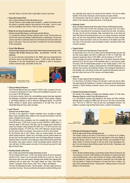
and Lake Titicaca. You must climb a large flight <strong>of</strong> steps to get there.Puma Uta Lookout Park3 km / 2 miles northwest <strong>of</strong> <strong>Puno</strong> (20 minutes by car)The park features a puma shaped stone monument – symbol <strong>of</strong> the lookout sincethis animal is a guardian related to the protection <strong>of</strong> the Andes – built on a fountainthat symbolizes Lake Titicaca. There are many recreational areas.Bahia de los Incas Ecotourism Seawall8 blocks from the Main Square, on the shores <strong>of</strong> Lake TiticacaIt is a pedestrian walkway <strong>of</strong>fering a beautiful view <strong>of</strong> Lake Titicaca where youfind the solar clocks and calendars called Sukankas or Intihuatanas. The pre-Incacultures used them to determine where the ceremonial and sacrificial rituals weregoing to take place. They also used them to establish the territorial boundaries<strong>of</strong> the communities.Yaravi Ship MuseumAvenida Sesquicentenario 610, Sector Huaje (Hotel Sonesta Posada del Inca Pier).Telephone: (051) 36-9329. Visiting hours: Mon. – Sun. 8:00 A.M. – 5:15 P.M. - FreeadmissionIt is an iron ship built in Great Britain in the 1860’s that was transported fromthe Pacific coast to the High Plateau in pieces – 2766 in total. Inside, differentaccessories <strong>of</strong> the ship compartments are exhibited as well as documents,archives, historical maps, and models <strong>of</strong> that time.Floating Islands <strong>of</strong> the UrosDomingo Giribaldi / PromPerúUro WomanMylene D'Auriol / PromPerúTiticaca National ReserveThis Protected Natural Area was created in 1978 in order to preserve the naturalresources characteristic <strong>of</strong> Lake Titicaca and the highland ecosystem. It coversan area <strong>of</strong> 36.180 hectares.In the reserve, dozens <strong>of</strong> birds, fish, and amphibious species have been registeredlike flamingos or parihuanas, Andean geese, seagulls, Titicaca grebes, chullumpis,and Andean lapwings as well as numerous endangered species. You will findtwelve varieties <strong>of</strong> aquatic plants representative <strong>of</strong> the lake flora, the mostremarkable being the totora reeds and algae.Lake Titicaca10 blocks from the Main SquareThis lake is very important in Andean mythology since, according to legend,Manco Capac and Mama Ocllo, children <strong>of</strong> the sun god and founders <strong>of</strong> the IncaEmpire, emerged from its waters.Peru and Bolivia share sovereignty over this navigable lake, the highest in theworld (3810 masl / 12.497 fasl). It covers an area <strong>of</strong> 8559 km 2 (3305 miles 2 ), amaximum depth <strong>of</strong> 283 meters (928 feet), and the average water temperaturevaries from October to May between 9ºC (48ºF) and 11ºC (52ºF) and from Juneto September between -7ºC (19ºF) and -10ºC (14ºF). Moreover, the lake tempersthe area since without its presence, there would not be life at that altitude.On the Peruvian side <strong>of</strong> Lake Titicaca, there are several islands; the naturalislands include Amantani, Taquile, Soto, and Anapia, and the artificial islands arethe ones that the Uros people have built, each one <strong>of</strong>fering different attractions.Along the shores <strong>of</strong> the lake, totora reeds grow where different birds and fish likethe carachis, ispis, bogas, umantos, suches (an endanger specie), silverfish, andtrout call home. All these species are native <strong>of</strong> the area and are prized for theirhigh nutritional value.Floating Islands <strong>of</strong> the Uros5 km / 3 miles west <strong>of</strong> the <strong>Puno</strong> harbor (20 minutes by boat)The Uros Islands (3810 masl / 12.497 fasl) number around 20 and are located inthe Bay <strong>of</strong> <strong>Puno</strong>. Three to ten Uro-Aymaras families live on each one. They ro<strong>of</strong>their houses with totora reed carpets, although some families have replaced theirtraditional ro<strong>of</strong>s by metal ones. The largest Islands are Tupiri, Santa María,Tribuna, Toranipata, Chumi, Paraiso, Kapi, Titino, Tinajero, and Negrone.The Uros call themselves Kotsuña, “the lake people”, and their origins go back toeras before the Incas. They hunt wild birds and maintain traditional fishing methods,especially those used for the carachi and the silverfish. The men are skillfulhandlers <strong>of</strong> the totora reed boats, and the women are expert knitters.The characteristic cold and dry weather <strong>of</strong> the region is tempered in this areathanks to the constantly evaporating water <strong>of</strong> the large lake.Amantani Island36 km / 22 miles northeast <strong>of</strong> the <strong>Puno</strong> harbor (3 hours and 30 minutes by boat)Located at 3187 masl (10.453 fasl), Amantani covers some 9 km 2 (3.5 miles 2 ).The flora is characterized by the presence <strong>of</strong> bushes like the muña, the kantuta,the sage, the tola and the patamuña. Eight communities live on the island andmake their living from growing potatoes, corn, oca, quinoa, lima beans, and greenpeas, and their most representative handcrafts are textiles and stone carvings.Among its natural attractions, there are two lookouts on the highest part <strong>of</strong>feringa view <strong>of</strong> the entire lake, some pre-Hispanic remains, ceremonial centers anda mummy cemetery.Taquile Island35 km / 22 miles east <strong>of</strong> the <strong>Puno</strong> port (3 hours by boat)Its approximate size is <strong>of</strong> 6 km 2 (2 miles 2 ) and the altitude between the port andthe town varies slightly from 3810 to 3950 masl (12.497 to 12.956 fasl). Themaximum temperature there is 23ºC (66ºF), and the minimum is 7ºC (37ºF).Pre-Inca vestiges are found in the highest part <strong>of</strong> the island. During the Colonialperiod and up to the first years <strong>of</strong> the twentieth century, it was used as a politicalprison, until the island became property <strong>of</strong> the Taquile people in 1970. Thetown <strong>of</strong> the same name, Taquile, is characterized by its friendly inhabitants, whomaintain their customs and traditional clothing. They distinguish themselves bytheir detailed, fine, and colorful textiles with symmetrical decorations and symbolsthat reflect their way <strong>of</strong> life, customs, and Andean beliefs.Chucuito18 km / 11 miles south <strong>of</strong> <strong>Puno</strong> (15 minutes by car)It is also known as the Royal Treasury City because it used to be the tax collectioncenter during the Colonial era. It features a main square and the Renaissancechurches <strong>of</strong> Santo Domingo (sixteenth century) and La Asuncion (seventeenthcentury).Cutimbo Archeological ComplexThe turn<strong>of</strong>f to the complex is located near kilometer marker 17 <strong>of</strong> the <strong>Puno</strong>-Moquegua Highway, south <strong>of</strong> <strong>Puno</strong> (20 minutes by car).It is a pre-Hispanic cemetery that belonged to the Lupaca and Colla Lordships.Although there is evidence <strong>of</strong> 8000 years old rock-art, the main structures datefrom 1100 A.D. to 1450 A.D. There are also Inca archeological remnants. Thechullpas or pucullos, large fortified burial towers, overlook the landscape.Amantani IslandDomingo Giribaldi / PromPerúChucuito Carlos Sala / PromPerúSillustani Archeological Complex34 km /21 miles north <strong>of</strong> <strong>Puno</strong> (35 minutes by car)This complex stands on the shore <strong>of</strong> Lake Umayo. It is famous for its chullpas,large circular fortified burial towers for the main leaders <strong>of</strong> the early villages <strong>of</strong>the Collao plateau. Some are 12 meters high (39 feet), and remarkable for theirshape, thinner at the base and wider at the top. Close to the archeological complexis the site museum where different pieces from the Colla, Tiahuanuaco, andInca cultures are preserved.Llachon74 km / 46 miles northeast <strong>of</strong> <strong>Puno</strong>, on the shores <strong>of</strong> Lake Titicaca (2 hours by car)This community <strong>of</strong> around 1300 inhabitants still maintains its customs and nativecultural manifestations, and its main activities are farming, cattle breeding, fishing,and handicraft. Llachon can be reached by motorboat from <strong>Puno</strong> harbor andfrom the Islands <strong>of</strong> Taquile and Amantani or by land from <strong>Puno</strong> or Juliaca. Theplace <strong>of</strong>fers experimental tourism, “living tourism”, allowing visitors to stay withfamilies <strong>of</strong> the community.