Forest cover and deforestation in Jamaica - the Forestry Department
Forest cover and deforestation in Jamaica - the Forestry Department
Forest cover and deforestation in Jamaica - the Forestry Department

Create successful ePaper yourself
Turn your PDF publications into a flip-book with our unique Google optimized e-Paper software.
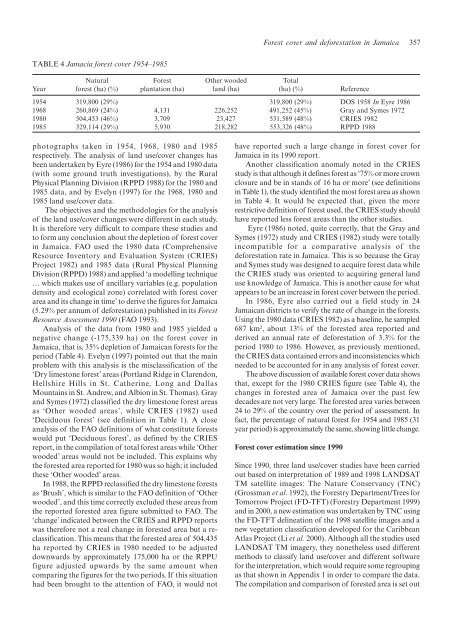
TABLE 4 Jamacia forest <strong>cover</strong> 1954–1985<br />
photographs taken <strong>in</strong> 1954, 1968, 1980 <strong>and</strong> 1985<br />
respectively. The analysis of l<strong>and</strong> use/<strong>cover</strong> changes has<br />
been undertaken by Eyre (1986) for <strong>the</strong> 1954 <strong>and</strong> 1980 data<br />
(with some ground truth <strong>in</strong>vestigations), by <strong>the</strong> Rural<br />
Physical Plann<strong>in</strong>g Division (RPPD 1988) for <strong>the</strong> 1980 <strong>and</strong><br />
1985 data, <strong>and</strong> by Evelyn (1997) for <strong>the</strong> 1968, 1980 <strong>and</strong><br />
1985 l<strong>and</strong> use/<strong>cover</strong> data.<br />
The objectives <strong>and</strong> <strong>the</strong> methodologies for <strong>the</strong> analysis<br />
of <strong>the</strong> l<strong>and</strong> use/<strong>cover</strong> changes were different <strong>in</strong> each study.<br />
It is <strong>the</strong>refore very difficult to compare <strong>the</strong>se studies <strong>and</strong><br />
to form any conclusion about <strong>the</strong> depletion of forest <strong>cover</strong><br />
<strong>in</strong> <strong>Jamaica</strong>. FAO used <strong>the</strong> 1980 data (Comprehensive<br />
Resource Inventory <strong>and</strong> Evaluation System (CRIES)<br />
Project 1982) <strong>and</strong> 1985 data (Rural Physical Plann<strong>in</strong>g<br />
Division (RPPD) 1988) <strong>and</strong> applied ‘a modell<strong>in</strong>g technique<br />
… which makes use of ancillary variables (e.g. population<br />
density <strong>and</strong> ecological zone) correlated with forest <strong>cover</strong><br />
area <strong>and</strong> its change <strong>in</strong> time’ to derive <strong>the</strong> figures for <strong>Jamaica</strong><br />
(5.29% per annum of <strong>deforestation</strong>) published <strong>in</strong> its <strong>Forest</strong><br />
Resource Assessment 1990 (FAO 1993).<br />
Analysis of <strong>the</strong> data from 1980 <strong>and</strong> 1985 yielded a<br />
negative change (-175,339 ha) on <strong>the</strong> forest <strong>cover</strong> <strong>in</strong><br />
<strong>Jamaica</strong>, that is, 35% depletion of <strong>Jamaica</strong>n forests for <strong>the</strong><br />
period (Table 4). Evelyn (1997) po<strong>in</strong>ted out that <strong>the</strong> ma<strong>in</strong><br />
problem with this analysis is <strong>the</strong> misclassification of <strong>the</strong><br />
‘Dry limestone forest’ areas (Portl<strong>and</strong> Ridge <strong>in</strong> Clarendon,<br />
Hellshire Hills <strong>in</strong> St. Ca<strong>the</strong>r<strong>in</strong>e, Long <strong>and</strong> Dallas<br />
Mounta<strong>in</strong>s <strong>in</strong> St. Andrew, <strong>and</strong> Albion <strong>in</strong> St. Thomas). Gray<br />
<strong>and</strong> Symes (1972) classified <strong>the</strong> dry limestone forest areas<br />
as ‘O<strong>the</strong>r wooded areas’, while CRIES (1982) used<br />
‘Deciduous forest’ (see def<strong>in</strong>ition <strong>in</strong> Table 1). A close<br />
analysis of <strong>the</strong> FAO def<strong>in</strong>itions of what constitute forests<br />
would put ‘Deciduous forest’, as def<strong>in</strong>ed by <strong>the</strong> CRIES<br />
report, <strong>in</strong> <strong>the</strong> compilation of total forest areas while ‘O<strong>the</strong>r<br />
wooded’ areas would not be <strong>in</strong>cluded. This expla<strong>in</strong>s why<br />
<strong>the</strong> forested area reported for 1980 was so high; it <strong>in</strong>cluded<br />
<strong>the</strong>se ‘O<strong>the</strong>r wooded’ areas.<br />
In 1988, <strong>the</strong> RPPD reclassified <strong>the</strong> dry limestone forests<br />
as ‘Brush’, which is similar to <strong>the</strong> FAO def<strong>in</strong>ition of ‘O<strong>the</strong>r<br />
wooded’, <strong>and</strong> this time correctly excluded <strong>the</strong>se areas from<br />
<strong>the</strong> reported forested area figure submitted to FAO. The<br />
‘change’ <strong>in</strong>dicated between <strong>the</strong> CRIES <strong>and</strong> RPPD reports<br />
was <strong>the</strong>refore not a real change <strong>in</strong> forested area but a reclassification.<br />
This means that <strong>the</strong> forested area of 504,435<br />
ha reported by CRIES <strong>in</strong> 1980 needed to be adjusted<br />
downwards by approximately 175,000 ha or <strong>the</strong> RPPU<br />
figure adjusted upwards by <strong>the</strong> same amount when<br />
compar<strong>in</strong>g <strong>the</strong> figures for <strong>the</strong> two periods. If this situation<br />
had been brought to <strong>the</strong> attention of FAO, it would not<br />
<strong>Forest</strong> <strong>cover</strong> <strong>and</strong> <strong>deforestation</strong> <strong>in</strong> <strong>Jamaica</strong> 357<br />
Natural <strong>Forest</strong> O<strong>the</strong>r wooded Total<br />
Year forest (ha) (%) plantation (ha) l<strong>and</strong> (ha) (ha) (%) Reference<br />
1954 319,800 (29%) 319,800 (29%) DOS 1958 In Eyre 1986<br />
1968 260,869 (24%) 4,131 226,252 491,252 (45%) Gray <strong>and</strong> Symes 1972<br />
1980 504,453 (46%) 3,709 23,427 531,589 (48%) CRIES 1982<br />
1985 329,114 (29%) 5,930 218,282 553,326 (48%) RPPD 1988<br />
have reported such a large change <strong>in</strong> forest <strong>cover</strong> for<br />
<strong>Jamaica</strong> <strong>in</strong> its 1990 report.<br />
Ano<strong>the</strong>r classification anomaly noted <strong>in</strong> <strong>the</strong> CRIES<br />
study is that although it def<strong>in</strong>es forest as ‘75% or more crown<br />
closure <strong>and</strong> be <strong>in</strong> st<strong>and</strong>s of 16 ha or more’ (see def<strong>in</strong>itions<br />
<strong>in</strong> Table 1), <strong>the</strong> study identified <strong>the</strong> most forest area as shown<br />
<strong>in</strong> Table 4. It would be expected that, given <strong>the</strong> more<br />
restrictive def<strong>in</strong>ition of forest used, <strong>the</strong> CRIES study should<br />
have reported less forest areas than <strong>the</strong> o<strong>the</strong>r studies.<br />
Eyre (1986) noted, quite correctly, that <strong>the</strong> Gray <strong>and</strong><br />
Symes (1972) study <strong>and</strong> CRIES (1982) study were totally<br />
<strong>in</strong>compatible for a comparative analysis of <strong>the</strong><br />
<strong>deforestation</strong> rate <strong>in</strong> <strong>Jamaica</strong>. This is so because <strong>the</strong> Gray<br />
<strong>and</strong> Symes study was designed to acquire forest data while<br />
<strong>the</strong> CRIES study was oriented to acquir<strong>in</strong>g general l<strong>and</strong><br />
use knowledge of <strong>Jamaica</strong>. This is ano<strong>the</strong>r cause for what<br />
appears to be an <strong>in</strong>crease <strong>in</strong> forest <strong>cover</strong> between <strong>the</strong> period.<br />
In 1986, Eyre also carried out a field study <strong>in</strong> 24<br />
<strong>Jamaica</strong>n districts to verify <strong>the</strong> rate of change <strong>in</strong> <strong>the</strong> forests.<br />
Us<strong>in</strong>g <strong>the</strong> 1980 data (CRIES 1982) as a basel<strong>in</strong>e, he sampled<br />
687 km², about 13% of <strong>the</strong> forested area reported <strong>and</strong><br />
derived an annual rate of <strong>deforestation</strong> of 3.3% for <strong>the</strong><br />
period 1980 to 1986. However, as previously mentioned,<br />
<strong>the</strong> CRIES data conta<strong>in</strong>ed errors <strong>and</strong> <strong>in</strong>consistencies which<br />
needed to be accounted for <strong>in</strong> any analysis of forest <strong>cover</strong>.<br />
The above discussion of available forest <strong>cover</strong> data shows<br />
that, except for <strong>the</strong> 1980 CRIES figure (see Table 4), <strong>the</strong><br />
changes <strong>in</strong> forested area of <strong>Jamaica</strong> over <strong>the</strong> past few<br />
decades are not very large. The forested area varies between<br />
24 to 29% of <strong>the</strong> country over <strong>the</strong> period of assessment. In<br />
fact, <strong>the</strong> percentage of natural forest for 1954 <strong>and</strong> 1985 (31<br />
year period) is approximately <strong>the</strong> same, show<strong>in</strong>g little change.<br />
<strong>Forest</strong> <strong>cover</strong> estimation s<strong>in</strong>ce 1990<br />
S<strong>in</strong>ce 1990, three l<strong>and</strong> use/<strong>cover</strong> studies have been carried<br />
out based on <strong>in</strong>terpretation of 1989 <strong>and</strong> 1998 LANDSAT<br />
TM satellite images: The Nature Conservancy (TNC)<br />
(Grossman et al. 1992), <strong>the</strong> <strong>Forest</strong>ry <strong>Department</strong>/Trees for<br />
Tomorrow Project (FD-TFT) (<strong>Forest</strong>ry <strong>Department</strong> 1999)<br />
<strong>and</strong> <strong>in</strong> 2000, a new estimation was undertaken by TNC us<strong>in</strong>g<br />
<strong>the</strong> FD-TFT del<strong>in</strong>eation of <strong>the</strong> 1998 satellite images <strong>and</strong> a<br />
new vegetation classification developed for <strong>the</strong> Caribbean<br />
Atlas Project (Li et al. 2000). Although all <strong>the</strong> studies used<br />
LANDSAT TM imagery, <strong>the</strong>y none<strong>the</strong>less used different<br />
methods to classify l<strong>and</strong> use/<strong>cover</strong> <strong>and</strong> different software<br />
for <strong>the</strong> <strong>in</strong>terpretation, which would require some regroup<strong>in</strong>g<br />
as that shown <strong>in</strong> Appendix 1 <strong>in</strong> order to compare <strong>the</strong> data.<br />
The compilation <strong>and</strong> comparison of forested area is set out