Forest cover and deforestation in Jamaica - the Forestry Department
Forest cover and deforestation in Jamaica - the Forestry Department
Forest cover and deforestation in Jamaica - the Forestry Department

Create successful ePaper yourself
Turn your PDF publications into a flip-book with our unique Google optimized e-Paper software.
360 O.B. Evelyn <strong>and</strong> R. Camir<strong>and</strong><br />
of satellite images us<strong>in</strong>g <strong>the</strong> classification system<br />
developed;<br />
• undertake <strong>in</strong>terpretation us<strong>in</strong>g satellite images every 5<br />
or 10 years with <strong>the</strong> same def<strong>in</strong>ition of vegetation types<br />
<strong>and</strong> <strong>the</strong> same methodology of <strong>in</strong>terpretation;<br />
• carry out periodic detailed analysis us<strong>in</strong>g aerial<br />
photography for management plann<strong>in</strong>g purposes <strong>and</strong><br />
<strong>the</strong> monitor<strong>in</strong>g of localised changes; <strong>and</strong><br />
• monitor any destructive changes that are tak<strong>in</strong>g place<br />
<strong>in</strong> <strong>the</strong> forests <strong>and</strong> develop mitigation measures to deal<br />
with <strong>the</strong>m.<br />
As a first step, an analysis of forest <strong>cover</strong> change over <strong>the</strong><br />
period 1989 to 1998 was carried out by <strong>the</strong> FD-TFT us<strong>in</strong>g<br />
<strong>the</strong> follow<strong>in</strong>g LANDSAT TM images:<br />
• full scene 012/047 (10 Dec 1989), full scene 011/047 (03<br />
Dec 1989) <strong>and</strong> quarter scene 011/047 (12 Nov 1990);<br />
• full scene 012/047 (07 April 1998), quarter scene 012/<br />
047 (02 Feb 1998) <strong>and</strong> full scene 011/047 (04 Oct 1996).<br />
The system developed for <strong>the</strong> LANDSAT TM <strong>in</strong>terpretation<br />
was limited to a mapp<strong>in</strong>g scale of 1:100,000. The smallest<br />
area or polygon to be resolved was 25.0 ha. A supervised<br />
classification system was used <strong>and</strong> over 100 locations isl<strong>and</strong>wide<br />
were visited for ‘ground truth<strong>in</strong>g’ purposes (<strong>and</strong><br />
photographed) <strong>and</strong> <strong>the</strong> coord<strong>in</strong>ates taken by GPS for<br />
verification purposes. Aerial photographs (1991–92 1:15,000<br />
<strong>and</strong> 1999 1:40,000) were also used to verify seven large<br />
blocks, which were very difficult to <strong>in</strong>terpret because of<br />
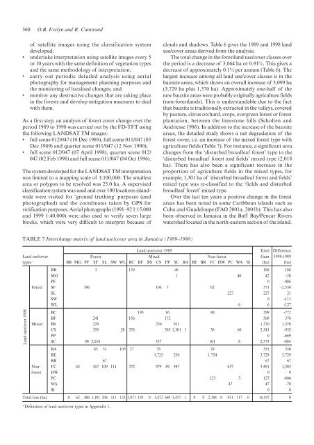
TABLE 7 Interchange matrix of l<strong>and</strong> use/<strong>cover</strong> area <strong>in</strong> <strong>Jamaica</strong> (1989–1998)<br />
clouds <strong>and</strong> shadows. Table 6 gives <strong>the</strong> 1989 <strong>and</strong> 1998 l<strong>and</strong><br />
use/<strong>cover</strong> areas derived from <strong>the</strong> analysis.<br />
The total change <strong>in</strong> <strong>the</strong> forestl<strong>and</strong> use/<strong>cover</strong> classes over<br />
<strong>the</strong> period is a decrease of 3,064 ha or 0.91%. This gives a<br />
decrease of approximately 0.1% per annum (Table 6). The<br />
largest <strong>in</strong>crease among all l<strong>and</strong> use/<strong>cover</strong> classes is <strong>in</strong> <strong>the</strong><br />
bauxite areas, which shows an overall <strong>in</strong>crease of 5,099 ha<br />
(3,729 ha plus 1,370 ha). Approximately one-half of <strong>the</strong><br />
new bauxite areas were probably orig<strong>in</strong>ally agriculture fields<br />
(non-forestl<strong>and</strong>s). This is underst<strong>and</strong>able due to <strong>the</strong> fact<br />
that bauxite is traditionally extracted <strong>in</strong> <strong>the</strong> valleys, <strong>cover</strong>ed<br />
by pasture, citrus orchard, crops, evergreen forest or forest<br />
plantation, between <strong>the</strong> limestone hills (Scholten <strong>and</strong><br />
Andriesse 1986). In addition to <strong>the</strong> <strong>in</strong>crease of <strong>the</strong> bauxite<br />
areas, <strong>the</strong> detailed study shows a net degradation of <strong>the</strong><br />
forest <strong>cover</strong>, i.e. an <strong>in</strong>crease of <strong>the</strong> mixed forest type with<br />
agriculture fields (Table 7). For <strong>in</strong>stance, a significant area<br />
changes from <strong>the</strong> ‘disturbed broadleaf forest’ type to <strong>the</strong><br />
‘disturbed broadleaf forest <strong>and</strong> fields’ mixed type (2,018<br />
ha). There has also been a significant <strong>in</strong>crease <strong>in</strong> <strong>the</strong><br />
proportion of agriculture fields <strong>in</strong> <strong>the</strong> mixed types, for<br />
example, 1,301 ha of ‘disturbed broadleaf forest <strong>and</strong> fields’<br />
mixed type was re-classified to <strong>the</strong> ‘fields <strong>and</strong> disturbed<br />
broadleaf forest’ mixed type.<br />
Over <strong>the</strong> last ten years a positive change <strong>in</strong> <strong>the</strong> forest<br />
areas has been noted <strong>in</strong> some Caribbean isl<strong>and</strong>s such as<br />
Cuba <strong>and</strong> Guadeloupe (FAO 2001a, 2001b). This has also<br />
been observed <strong>in</strong> <strong>Jamaica</strong> <strong>in</strong> <strong>the</strong> Buff Bay/Pencar Rivers<br />
watershed located <strong>in</strong> <strong>the</strong> north-eastern section of <strong>the</strong> isl<strong>and</strong>.<br />
L<strong>and</strong> use/<strong>cover</strong> 1989 Total Difference<br />
L<strong>and</strong> use/<strong>cover</strong> <strong>Forest</strong> Mixed Non-forest Ga<strong>in</strong> 1998-1989<br />
types 1 BB MG PF SF SL SW WL BC BF BS CS PP SC BA BE BR FC HW PC WA SI (ha) (ha)<br />
BB 3 139 46 188 188<br />
MG 1 40 42 -20<br />
PF 0 -486<br />
<strong>Forest</strong> SF 396 106 7 62 571 -2,530<br />
SL 227 227 21<br />
SW 0 -111<br />
WL 6 6 -127<br />
BC 193 16 90 299 -772<br />
BF 241 156 172 569 376<br />
Mixed BS 229 230 911 1,370 1,370<br />
CS 359 28 378 385 1,301 1 30 60 2,541 -932<br />
PP 0 -669<br />
SC 90 2,018 357 101 8 2,573 -884<br />
BA 85 31 105 27 76 29 351 350<br />
BE 1,725 250 1,754 3,729 3,729<br />
BR 67 67 67<br />
Non- FC 62 167 109 111 372 979 89 947 657 3,491 1,303<br />
forest HW 0 0<br />
PC 123 3 127 -804<br />
WA 47 47 -70<br />
SI 0 0<br />
L<strong>and</strong> use/<strong>cover</strong> 1998<br />
Total loss (ha) 0 62 486 3,101 206 111 133 1,071 193 0 3,472 669 3,457 1 0 0 2,188 0 931 117 0 16,197 0<br />
1 Def<strong>in</strong>ition of l<strong>and</strong> use/<strong>cover</strong> types <strong>in</strong> Appendix 1.