

Design First, Codify Second: Germany Offers Lessons for
Design First, Codify Second: Germany Offers Lessons for
Design First, Codify Second: Germany Offers Lessons for

Create successful ePaper yourself
Turn your PDF publications into a flip-book with our unique Google optimized e-Paper software.
u. 24<br />
<strong>Design</strong> <strong>First</strong>,<br />
<strong>Codify</strong> <strong>Second</strong><br />
n <strong>Germany</strong>, mban design happens<br />
first and then zoning codifies the<br />
design into law. Does this practice lead<br />
to better built environments? American<br />
plmmers may find that it does.<br />
German zoning was the original inspiration<br />
<strong>for</strong> American re<strong>for</strong>mers who<br />
implemented zoning in New York City in<br />
1916-the first such venture in the US. I<br />
was curious to see if <strong>Germany</strong> offered lessons<br />
almost a centulY later.<br />
"When I lived in Berlin as a Fulbright<br />
scholar <strong>for</strong> a year in 2007 and 2008, I was<br />
velY impressed by how convenient it was to<br />
walk to shops and take transit evelywhere<br />
I wanted to go. I tried to explain my excitement<br />
to German planners, noting that<br />
our fairly new concept of transit-oriented<br />
development-which didn't translate-is<br />
just regular development in <strong>Germany</strong>.<br />
<strong>Germany</strong> is considerably smaller and<br />
denser than the US., with a population of<br />
82 million living in about 138,000 square<br />
lniles-a land area just slightly smaller<br />
than Montana. In comparison, the U.S. has<br />
304 million people spread over 3.5 million<br />
square miles. German cities have excellent<br />
public transportation and are laid out with<br />
shops, housing, and workplaces within<br />
walking distance of one another.<br />
Given tile orderliness of German culture,<br />
how can the planning regulations<br />
manage such an incredible mix of uses?<br />
Despite similar initial zoning, German<br />
I Planning July 2009<br />
regulations incorporated mixed use concepts<br />
while tile US. diverged on a singleuse<br />
path. The German planning system<br />
offers inspiration to American counterparts<br />
seeking to solve administrative problems,<br />
mix uses more easily, and create better<br />
places by design.<br />
A highly coordinated system<br />
<strong>First</strong>, a word about the overall planning<br />
system in <strong>Germany</strong>. "It is velY important<br />
to understand the holistic system of spatial<br />
planning in <strong>Germany</strong>," says Harald Keglar,<br />
an urban planning professor at Bauhaus<br />
University in Weimar. Tllis system<br />
is characterized by the Gegenstro771prinz<br />
or "counter-current rprinciple," which requires<br />
objectives to pass from tile federal<br />
level down and feedback to filter from the<br />
local level up.<br />
At · the federal level, a single German<br />
agency, the Federal Mlllisuy of Transport,<br />
Building and Urban Affairs is responsible<br />
<strong>for</strong> the national spatial planning law, which<br />
outlines the framework principles, procedures,<br />
and goals. (This integrated system<br />
of transportation and land use stands in<br />
marked contrast to the U.S., where tile<br />
Department of Transportation and tile<br />
Housing and Urban Development Department<br />
agreed to work togetller on joint<br />
policy <strong>for</strong> tile first time just tllis March.)<br />
The minisuy also is responsible <strong>for</strong><br />
updating and publishing the German Na-<br />
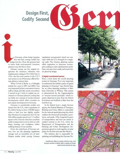
Frankfurter Allee is a major vehicle, train, and<br />
bicycle corridor in Berlin with a variety of shops<br />
and services along the way.
tional Building Law, the Baugesetzbucb or<br />
BauGB, every two years. The BauGB, a<br />
book about the size of a paperback novel,<br />
specifies the regulatOlY framework <strong>for</strong><br />
planning at each level of govermnent. It is<br />
used by German plalmers regularly just as<br />
American city planners frequently refer to<br />
tlleir local zoning ordinance.<br />
At the next level, each one of tlle 16<br />
German states is required to complete a<br />
state development plan mat draws a line<br />
between densely populated areas and open<br />
space. Spatial development goals identify<br />
corridors anticipated <strong>for</strong> developlnent and<br />
areas set aside <strong>for</strong> green space preservation.<br />
Regional planning, completed by a<br />
state-level deparunent or an association of<br />
municipalities, coordinates tlle development<br />
of u'ansportation and otller public<br />
infi:asu'ucture across sectors of government.<br />
An underlying principle is to concentrate<br />
new urban development arOlUld<br />
u'ansportation infi:asu·ucture.<br />
Municipal planning in <strong>Germany</strong> includes<br />
two main parts. The preparatory<br />
land-use plan, me Flaecbennutzzmgsplan<br />
or F-plan, can be tllought of as a cross between<br />
an American comprehensive plan<br />
and a zoning plan. The F -plan is usually<br />
completed evelY 10 to 15 years and is required<br />
to align wim state and regional<br />
planning objectives.<br />
Altllough a generalized indication of<br />
land use is sufficient, in practice tlle F-<br />
The Freiburg F-Plan designates the permitted land<br />
uses, but does not specify building <strong>for</strong>m. The mixed<br />
use areas (brown) typically follow transportation<br />
corridors and t ransition to res idential (pink) mid-block.<br />
offers lessons<br />
<strong>for</strong> u.s. planners<br />
By Faith Cable<br />
plan often specifies land use on a lot level.<br />
Adjusunents may be made by a municipality<br />
outside of tlle normal planning process<br />
but must be approved by the regional government.<br />
The BebflZumgsplan or B-Plmz, sometimes<br />
u'anslated as a "legally binding<br />
land-use plan," is a regulating plan <strong>for</strong> a<br />
small area. Derived from tlle F-plan, me<br />
B-plan defines zoning requirements at me<br />
lot level and includes a site plan and text.<br />
The B-Plan governs tlle consUlICtion or<br />
alteration of buildings on a site, outlines<br />
the provision of public infrasUl.lcture, and<br />
serves as a plat map.<br />
How the German B-Plan works<br />
The German B-plan, which is similar to<br />
me master plan of a PUD or tlle regulating<br />
plan of a <strong>for</strong>m-based code, includes<br />
requirements familiar to an American<br />
planner: floor-area ratio, height, setback,<br />
and land use. However, the process by<br />
which tllese standards are applied differs.<br />
An important distinction is tllat a B-plan<br />
lists "land use" as one of many regulating<br />
criteria applied to each parcel- in contrast<br />
to conventional American zoning, which<br />
organizes parcels into use-based disu'icts,<br />
each witll a list of regulating criteria.<br />
The first mree of me following four<br />
categories are required elements.<br />
Local transportation areas. Local u'ansportation<br />
areas typically specify vehicle<br />
Ameri ca n Planning Association 25
travel lanes, sidewalks, bicycle lanes, and<br />
the location of transit lines, as applicable.<br />
Type ofbztildinguse. The type of building<br />
use refers to the traditional definition of<br />
"use" in the U.S.: residential, commercial,<br />
or industrial. There are just lOuse districts<br />
in <strong>Germany</strong> defined by the BauGB, far<br />
fewer than in most American cities. The<br />
German use districts include small-scale<br />
residential, restricted residential, general<br />
residential, special residential, village area,<br />
mixed use area, town or city, commercial<br />
area, and industrial area.<br />
Although the use districts have a predominant<br />
use, a mix of these uses is allowed<br />
in most of them. For example, in the<br />
restricted residential (Reine Wolmgebiete)<br />
district, residential buildings are allowed<br />
by right and conditional uses include retail<br />
and restaurants that serve the daily needs<br />
of residents; workshops; small hotels; and<br />
religious, cultural, health, and sports facilities.<br />
The "daily needs" test is seen as a way<br />
to encourage shops and services, such as<br />
a bakelY or drug store, to locate within<br />
walking distance of customers; however,<br />
the size of such businesses is limited.<br />
The general residential (Allgemeine<br />
Wohngebiete) district allows all the permitted<br />
and conditional uses of the restricted<br />
residential disu·ict as well as conditional<br />
uses such as hotels, non-disturbing industry,<br />
gas stations, and office buildings. In<br />
contrast to the U.S., where very restrictive<br />
single-family districts predominate,<br />
in <strong>Germany</strong> the most conunon residential<br />
district is general residential.<br />
Degree of building Zlse. The degree of<br />
building use refers to height and bulk<br />
standards. It is regulated by floor-area<br />
ratio or maximum number of units per<br />
lot; the number of stories, expressed as a<br />
range or a maximum; construction type;<br />
and building setbacks. The consullction<br />
type is either "open," allowing a fi:eestanding<br />
building, or "closed," requiring a party<br />
wall. Setbacks are regulated by build-within<br />
lipes and build-to lines that are drawn<br />
on the B-plan. The amount of land to be<br />
built on is regulated by the lot coverage<br />
ratio, an important concern to plamlers<br />
uying to minimize impervious surface<br />
coverage.<br />
Text nquirements. The text requirements<br />
spell out other standards, which<br />
may include building height, parking location<br />
or quantity, required u·ees, green<br />
roofs, and window placement. The text<br />
t ---2-6-r-p-la- n-n-i-ng- J-U-IY- 2-0-0-9---<br />
may restrict inappropriate uses such as gas<br />
stations, and in general this section of the<br />
B-plan acts as a catch-all <strong>for</strong> any other special<br />
resu·ictions.<br />
B-plan process<br />
B-plans are prepared by the municipality,<br />
usually in anticipation of future development.<br />
However, the development conununity<br />
has initiated much of that pI arming in<br />
recent years.<br />
"There are mal1y requests by investors<br />
who propose developJIlent ideas to the<br />
municipality," says Nicole Baumueller, a<br />
plalmer <strong>for</strong> the city of Stuttgart. "There<strong>for</strong>e,<br />
the Vorbabenbezogener Bebauungsplan,<br />
which creates a B-plan <strong>for</strong> the special proposal<br />
of an investor, has gained in importance,"<br />
Baumueller adds.<br />
The B-plan approval process starts<br />
with a review by a subcommittee of the<br />
city council and includes one or more<br />
public comment periods. Final adoption is<br />
ultimately a city council decision, and the<br />
B-plan becomes legally binding when it<br />
is armounced in the local press. As in the<br />
U.S., the approval process <strong>for</strong> a development<br />
project is not always a smooth one<br />
and there are sometimes vocal opponents,<br />
Baunmeller says. "In areas of the city with<br />
highly educate1 people, if a protest occurs,<br />
it is usually well-organized."<br />
Since B-plans are created <strong>for</strong> future<br />
development, some areas of a city do not<br />
have one. In these areas, small-scale new<br />
development generally is allowed if it is<br />
similar to the current context according to<br />
a "matching" principle.<br />
B-plans are provided on the interactive<br />
GIS websites of larger German municipalities,<br />
offering a clickable link from<br />
a city map of all B-plans to a legible image<br />
of the particular plan being sought. A<br />
property owner can view the applicable<br />
zoning requirements quickly and see all<br />
pertinent in<strong>for</strong>mation in one document.<br />
American comparisons<br />
The two elements of American zoning<br />
that most resemble German zoningplamled<br />
unit developments and <strong>for</strong>mbased<br />
codes-were compared by Donald<br />
Elliott, FAICP, in his new book, A Better Way<br />
to Zone. "Unlike PUDs and per<strong>for</strong>mance<br />
zoning, which were created to make Euclidean<br />
zoning more flexible, <strong>for</strong>m-based<br />
zoning was aimed at a different failing:<br />
that earlier tools were not producing the<br />
types of neighborhoods people wanted,"<br />
he writes. Elliott argues <strong>for</strong> holistic zoning<br />
re<strong>for</strong>ms that would allow <strong>for</strong> more flexibility-deemphasizing<br />
use, reemphasizing<br />
scale, and improving administration. In<br />
the quest <strong>for</strong> solutions, the German system<br />
offers new ideas toward how we think<br />
about zoning.<br />
Although they are flexible, the unique<br />
nature of each PUD and the plans used<br />
The German B-plan must include text, the<br />
regulating plan, and a key. B-plan notation is<br />
standardized throughout the country.<br />
<strong>for</strong> regulation can result in more complicated<br />
and time-consuming zoning adminisu·ation.<br />
PUDs are regulated by a<br />
Master Development Plan, which is usually<br />
composed of a set of plans similar to<br />
a preliminary plat submittal. Although a<br />
plan showing location, height, and square<br />
footage is clearly relevant to zoning, the<br />
documents do not typically distinguish<br />
legally mandated elements from other in<strong>for</strong>mation,<br />
such as the location of shrubs<br />
and peremuals.<br />
Instead of a quick reference to the zoning<br />
code <strong>for</strong> standard districts, PUD zoning<br />
verification takes more time. Furthermore,<br />
the "unit" aspect of a PUD, often<br />
a result of property ownerslup bowldaries<br />
prior to development, does not always lend<br />
itself easily to a change <strong>for</strong> a single property.<br />
"FAR and setbacks are determined<br />
<strong>for</strong> the entire PUD, not <strong>for</strong> each parcel,<br />
which makes it more challenging to determine<br />
the allowable zoning <strong>for</strong> an individual<br />
property owner," says Jeff Thomson, a<br />
plalmer in Mllmetonka, Mllmesota.<br />
Incorporating the Gennan concept of<br />
a single regulating plan into PUD ordinances<br />
could improve zoning adnunistra-