County Geology Site Criteria for Cornwall and the Isles of Scilly
County Geology Site Criteria for Cornwall and the Isles of Scilly
County Geology Site Criteria for Cornwall and the Isles of Scilly

Create successful ePaper yourself
Turn your PDF publications into a flip-book with our unique Google optimized e-Paper software.
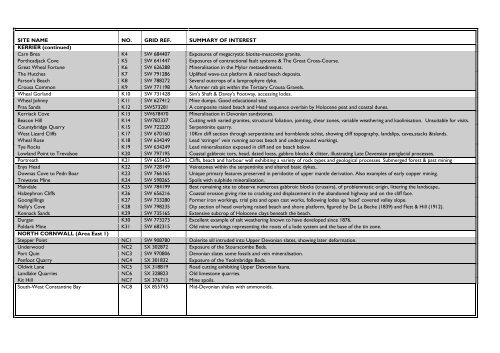
SITE NAME NO. GRID REF. SUMMARY OF INTERESTKERRIER (continued)Carn Brea K4 SW 684407 Exposures <strong>of</strong> megacrystic biotite-muscovite granite.Porthcadjack Cove K5 SW 641447 Exposures <strong>of</strong> contractional fault systems & The Great Cross-Course.Great Wheal Fortune K6 SW 626288 Mineralisation in <strong>the</strong> Mylor metasediments.The Hutches K7 SW 791286 Uplifted wave-cut plat<strong>for</strong>m & raised beach deposits.Parson's Beach K8 SW 788272 Several outcrops <strong>of</strong> a lamprophyre dyke.Crousa Common K9 SW 771198 A <strong>for</strong>mer rab pit within <strong>the</strong> Tertiary Crousa Gravels.Wheal Gorl<strong>and</strong> K10 SW 731428 Sim's Shaft & Davey's Footway, accessing lodes.Wheal Johnny K11 SW 627412 Mine dumps. Good educational site.Praa S<strong>and</strong>s K12 SW573281 A composite raised beach <strong>and</strong> Head sequence overlain by Holocene peat <strong>and</strong> coastal dunes.Kerriack Cove K13 SW678470 Mineralisation in Devonian s<strong>and</strong>stones.Beacon Hill K14 SW782337 Cutting with varied granites, structural foliation, jointing, shear zones, variable wea<strong>the</strong>ring <strong>and</strong> kaolinisation. Unsuitable <strong>for</strong> visits.<strong>County</strong>bridge Quarry K15 SW 722220 Serpentinite quarry.West Lizard Cliffs K17 SW 670160 10Km cliff section through serpentinite <strong>and</strong> hornblende schist, showing cliff topography, l<strong>and</strong>slips, caves,stacks &isl<strong>and</strong>s.Wheal Rose K18 SW 634249 Lead ‘stringer’ vein running across beach <strong>and</strong> underground workings.Tye Rocks K19 SW 634249 Lead mineralisation exposed in cliff <strong>and</strong> on beach below.Lowl<strong>and</strong> Point to Trevalsoe K20 SW 797195 Coastal gabbroic tors, head, dated loess, gabbro blocks & clitter, illustrating Late Devensian periglacial processes.Portreath K21 SW 655453 Cliffs, beach <strong>and</strong> harbour wall exhibiting a variety <strong>of</strong> rock types <strong>and</strong> geological processes. Submerged <strong>for</strong>est & past miningEnys Head K22 SW 728149 Veinstones within <strong>the</strong> serpentinite <strong>and</strong> altered basic dykes..Downas Cove to Pedn Boar K23 SW 766165 Unique primary features preserved in peridotite <strong>of</strong> upper mantle derivation. Also examples <strong>of</strong> early copper mining.Trewavas Mine K24 SW 598265 Spoils with sulphide mineralisation.Maindale K25 SW 784199 Best remaining site to observe numerous gabbroic blocks (crusairs), <strong>of</strong> problemmatic origin, littering <strong>the</strong> l<strong>and</strong>scape..Halzephron Cliffs K26 SW 656216 Coastal erosion giving rise to cracking <strong>and</strong> displacement in <strong>the</strong> ab<strong>and</strong>oned highway <strong>and</strong> on <strong>the</strong> cliff face.Goongillings K27 SW 733280 Former iron workings, trial pits <strong>and</strong> open cast works, following lodes up ‘head’ covered valley slope.Nelly’s Cove K28 SW 798235 Dip section <strong>of</strong> head overlying raised beach <strong>and</strong> shore plat<strong>for</strong>m, figured by De La Beche (1839) <strong>and</strong> Flett & Hill (1912).Kennack S<strong>and</strong>s K29 SW 735165 Extensive subcrop <strong>of</strong> Holocene clays beneath <strong>the</strong> beach.Durgan K30 SW 773273 Excellent example <strong>of</strong> salt wea<strong>the</strong>ring known to have developed since 1876.Poldark Mine K31 SW 682315 Old mine workings representing <strong>the</strong> roots <strong>of</strong> a lode system <strong>and</strong> <strong>the</strong> base <strong>of</strong> <strong>the</strong> tin zone.NORTH CORNWALL (Area East 1)Stepper Point NC1 SW 908780 Dolerite sill intruded into Upper Devonian slates, showing later de<strong>for</strong>mation.Underwood NC2 SX 302872 Exposure <strong>of</strong> <strong>the</strong> Stourscombe Beds.Port Quin NC3 SW 970806 Devonian slates some fossils <strong>and</strong> vein mineralisation.Penfoot Quarry NC4 SX 301832 Exposure <strong>of</strong> <strong>the</strong> Yeolmbridge Beds.Oldwit Lane NC5 SX 318819 Road cutting exhibiting Upper Devonian fauna.L<strong>and</strong>lake Quarries NC6 SX 328823 Old limestone quarries.Kit Hill NC7 SX 376713 Mine spoils.South-West Constantine Bay NC8 SX 855745 Mid-Devonian shales with ammonoids.