
You also want an ePaper? Increase the reach of your titles
YUMPU automatically turns print PDFs into web optimized ePapers that Google loves.
Prices Subject to Change Without Notice<br />
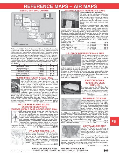
REFERENCE MAPS – AIR MAPS<br />
MEXICO VFR WAC CHARTS<br />
Published by INEGI - Mexico's National Institute of Statistics, Information<br />
& Geography. These World Aeronautical Charts (WAC) were released in<br />
2008 and contain topographical, airport and navaid information. Mexico<br />
is divided into 12 regions and 2 regions are printed on each chart for a<br />
total of 6 individual charts. Updated every 4 years. SCALE 1:1,000,000.<br />
Note that aircraft landing in Mexico that departed from Central America,<br />
South America or the Caribbean are subject to special AOE requirements<br />
and can only use the Cozumel and Tapachula airports as AOE's.<br />
Detailed airport information and fuel availablilty can be found in the Pilot's<br />
Guide.<br />
Description Part No. Price<br />
Monterey-N.Laredo 13-06079 $14.95<br />
Acapulco-Mexico 13-06080 $14.95<br />
Tuxtla Gutierz-Merida 13-06081 $14.95<br />
Chihuahua-Juarez 13-06082 $14.95<br />
Hermosillo-Mexicali 13-06083 $14.95<br />
Guadalajara-Culiacan 13-06084 $14.95<br />
PILOTS FREE FLIGHT ATLAS - USA<br />
Base cartography is the US Road-Atlas 1: 2.000.000<br />
which includes mountain ranges, lakes, rivers, etc. . As<br />
well, all other elements such as, cities, towns. Parks and<br />
points of interest or historic value and of course, the railways<br />
and motor-ways themselves.<br />
To this, they have added all airports in USA (over 5,500)<br />
and colour coded them by runway length /surface and<br />
category ,ie. International, Regional, Civil/Military, etc..<br />
VOR/DME , Reporting points, Waypoints), Volmet frequencies<br />
and special Use Airspace are also shown making our new<br />
"Pilots' Atlas" the first of it’s kind. Keymap for 106 pages cartography.<br />
Scale 1:2.000.000. Distance, Pilot Metro and Weather Radar Map<br />
Satellite Photo. Political Map. Cartography Captains Corner Airport<br />
Directory with over 5,500 airports. Captains Corner Conversion tables +<br />
crosswind component P/N 13-07299 .........................$31.95<br />
PILOTS FREE FLIGHT ATLAS -<br />
EASTERN HEMISPHERE<br />
(EUROPE, MIDDLE EAST, & SOUTHEAST, ASIA)<br />
JNC scale, topographical charts are used showing over<br />
4,500 airports Waypoints, VOR/DME, NDB´s and special<br />
use airspace are included, plus weather frequencies, points<br />
of interest, landmarks, airport-directory with ICAO-codes,<br />
railways, rivers, major highways, just to name a few. Airports<br />
are colour coded by runway length and surface. International/<br />
regional Aerodromes are coded by symbol shape.<br />
Pilots now have the ability to point out objects on the ground<br />
or know immediately where they are in relation to surrounding<br />
airports or points of interest: an all-in-one source of information for<br />
pre-flight or during flight. P/N 13-07300 .........................$38.75<br />
IFR AREA CHARTS - U.S.<br />
United States Government Flight Information<br />
Publication IFR Area Charts - U.S. Area consisting<br />
part of: * A-1 Minneapolis/St. Paul * Detroit<br />
* St. Louis * Atlanta * Jacksonville * Miami *<br />
Washington * A-2 San Francisco * Los Angeles<br />
* Phoenix * Denver * Kansas City * Dallas/Fort<br />
Worth * Chicago/Milwaukee<br />
P/N 13-00773...............................$4.45<br />
AVIATOR’S QUICK REFERENCE MAPS<br />
Flight Case Map - US 5th Edition<br />
This is the map that actually started it all and<br />
launched our business in 1988. The Aviators’<br />
Quick Reference Map has become standard<br />
equipment in the flight bags of thousands of<br />
professional pilots all over the world and is<br />
standard issue to the pilots of several major<br />
airlines.<br />
Colorful and accurate, these maps clearly<br />
depict state boundaries, time zones, major<br />
cities and towns, rivers, lakes, mountain<br />
ranges, national parks and points of interest. Also listed are major airports<br />
and VOR’s (with frequencies for easy identification). Hundreds of<br />
interesting state by state facts and figures are listed on the back side.<br />
Two finishes: laminated or tearproof. The laminated version has a writeon/wipe-off<br />
surface. Either is durable enough to with stand years of use.<br />
A great aid for making more interesting PA’s. When folded, laminated<br />
map measures 10.5” x 16” and tearproof is 8” x 10.75”. Both fit perfectly<br />
in a flight case. Scale 1”= 90 miles.<br />
Laminated U.S .....................................P/N 13-05677 ...................$28.95<br />
Tearproof U.S ......................................P/N 13-05678 ...................$28.95<br />
Tearproof Europe ................................P/N 13-05679 ...................$28.95<br />
Tearproof Latin America ......................P/N 13-05680 ...................$28.95<br />
Tearproof Alaska w/ Canada ...............P/N 13-05687 ...................$28.95<br />
U.S. QUICK REFERENCE WALL MAP<br />
Due to popular demand, we have come<br />
up with an extra large version of our<br />
popular Aviators’ Quick Reference Map<br />
and made it wall-size. Perfect for use at<br />
home, office, hangar, briefing room, etc.<br />
This map depicts state boundaries, time<br />
zones, major cities and towns, rivers,<br />
lakes, mountain ranges, national parks<br />
and other points of interest. Also listed are major airports and VOR’s<br />
(with frequencies for easy identification).<br />
It is ideal for flight planning or “pinning” your favorite destinations. Measures<br />
33” x 23” or 52” x 36” and is laminated so that you can write on it<br />
and just wipe it off. Makes for an attractive wall mount anywhere! Shipped<br />
to you rolled with no creases. Scale: 1”= 55 miles.<br />
Wall Map U.S. Expanded ....................P/N 13-05688 ...................$39.95<br />
AVIATOR’S QUICK<br />
REFERENCE DESK<br />
MAP - US<br />
The same map as the US Flight Case<br />
Map, without the folds and a 1 inch border<br />
added with lattitudes and longitudes.<br />
Heavy map paper and laminate. Full map<br />
size: 33 1/2” x 23”<br />
PN 13-05690 ....................$30.95<br />
FOLDED PILOT’S MAP<br />
This map measures 3 feet by 2 feet and is<br />
encapsulated on both sides by a rugged<br />
3 mil laminate for durability. The map is<br />
extremely detailed and includes hundreds<br />
of airports (civil and military), vor’s, ndb’s,<br />
terrain features, national parks, cities,<br />
time zones, etc. The back of the map has<br />
a very detailed AM radio frequency guide<br />
for all 50 states, the District of Columbia, Puerto Rico, and the U.S. Virgin<br />
Islands. Contains state information including capitals, square mileage,<br />
population, and nick names along with each state flag. Great for pilots<br />
and aviation enthusiasts. Flight plan information, ATC light gun signals,<br />
cruising altitudes, and a crosswind component chart included.<br />
Folded Pilot’s Map ...............................P/N 13-11247 ...................$18.75<br />
Pilot’s Laminated Wall Map .................P/N 13-11248 ...................$18.75<br />
AIR TRAVELERS MAP<br />
Intended for the airline or business jet<br />
passenger, this flight reference map is<br />
designed primarily for trip planning and<br />
referencing landmarks of the USA while in<br />
flight.<br />
Packed with useful information on cities,<br />
parks, highways, and other points of interest<br />
from California to Maine.<br />
The folded flight map is printed on durable tear-proof paper and fits perfectly<br />
in a seat pocket or briefcase, making it a great gift for the “Frequent<br />
Flyer”! Flight Map Measurements: 8 1/2” x 11”.<br />
P/N 14-02827 ...................$18.95<br />
AIRCRAFT SPRUCE WEST AIRCRAFT SPRUCE EAST<br />
CORONA, CA • (877) 4-SPRUCE PEACHTREE CITY, GA • (877) 477-7823 867<br />
CM<br />
WP<br />
ME<br />
HA<br />
AP<br />
LG<br />
EP<br />
CS<br />
IN<br />
EL<br />
AV<br />
TO<br />
PS<br />
BV