How to Read a Topographic Map and Delineate a Watershed
How to Read a Topographic Map and Delineate a Watershed
How to Read a Topographic Map and Delineate a Watershed

Create successful ePaper yourself
Turn your PDF publications into a flip-book with our unique Google optimized e-Paper software.
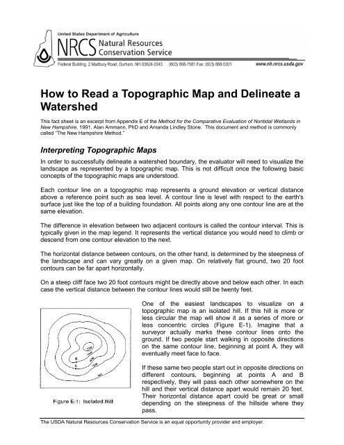
<strong>How</strong> <strong>to</strong> <strong>Read</strong> a <strong>Topographic</strong> <strong>Map</strong> <strong>and</strong> <strong>Delineate</strong> a<strong>Watershed</strong>This fact sheet is an excerpt from Appendix E of the Method for the Comparative Evaluation of Nontidal Wetl<strong>and</strong>s inNew Hampshire, 1991. Alan Ammann, PhD <strong>and</strong> Am<strong>and</strong>a Lindley S<strong>to</strong>ne. This document <strong>and</strong> method is commonlycalled “The New Hampshire Method.”Interpreting <strong>Topographic</strong> <strong>Map</strong>sIn order <strong>to</strong> successfully delineate a watershed boundary, the evalua<strong>to</strong>r will need <strong>to</strong> visualize thel<strong>and</strong>scape as represented by a <strong>to</strong>pographic map. This is not difficult once the following basicconcepts of the <strong>to</strong>pographic maps are unders<strong>to</strong>od.Each con<strong>to</strong>ur line on a <strong>to</strong>pographic map represents a ground elevation or vertical distanceabove a reference point such as sea level. A con<strong>to</strong>ur line is level with respect <strong>to</strong> the earth'ssurface just like the <strong>to</strong>p of a building foundation. All points along any one con<strong>to</strong>ur line are at thesame elevation.The difference in elevation between two adjacent con<strong>to</strong>urs is called the con<strong>to</strong>ur interval. This istypically given in the map legend. It represents the vertical distance you would need <strong>to</strong> climb ordescend from one con<strong>to</strong>ur elevation <strong>to</strong> the next.The horizontal distance between con<strong>to</strong>urs, on the other h<strong>and</strong>, is determined by the steepness ofthe l<strong>and</strong>scape <strong>and</strong> can vary greatly on a given map. On relatively flat ground, two 20 footcon<strong>to</strong>urs can be far apart horizontally.On a steep cliff face two 20 foot con<strong>to</strong>urs might be directly above <strong>and</strong> below each other. In eachcase the vertical distance between the con<strong>to</strong>ur lines would still be twenty feet.One of the easiest l<strong>and</strong>scapes <strong>to</strong> visualize on a<strong>to</strong>pographic map is an isolated hill. If this hill is more orless circular the map will show it as a series of more orless concentric circles (Figure E-1). Imagine that asurveyor actually marks these con<strong>to</strong>ur lines on<strong>to</strong> theground. If two people start walking in opposite directionson the same con<strong>to</strong>ur line, beginning at point A, they willeventually meet face <strong>to</strong> face.If these same two people start out in opposite directions ondifferent con<strong>to</strong>urs, beginning at points A <strong>and</strong> Brespectively, they will pass each other somewhere on thehill <strong>and</strong> their vertical distance apart would remain 20 feet.Their horizontal distance apart could be great or smalldepending on the steepness of the hillside where theypass.The USDA Natural Resources Conservation Service is an equal opportunity provider <strong>and</strong> employer.
A rather more complicated situation is one where two hills are connected by a saddle (Figure E-2). Here each hill is circled by con<strong>to</strong>urs but at some point <strong>to</strong>ward the base of the hills, con<strong>to</strong>ursbegin <strong>to</strong> circle both hills.<strong>How</strong> do con<strong>to</strong>urs relate <strong>to</strong> water flow? A general ruleof thumb is that water flow is perpendicular <strong>to</strong>con<strong>to</strong>ur lines. In the case of the isolated hill, waterflows down on all sides of the hill. Water flows fromthe <strong>to</strong>p of the saddle or ridge, down each side in thesame way water flows down each side of a gardenwall (See arrow on Figure E-2).As the water continues downhill it flows in<strong>to</strong>progressively larger watercourses <strong>and</strong> ultimately in<strong>to</strong>the ocean. Any point on a watercourse can be used<strong>to</strong> define a watershed. That is, the entire drainagearea of a major river like the Merrimack can beconsidered a watershed, but the drainage areas ofeach of its tributaries are also watersheds.Each tributary in turn has tributaries, <strong>and</strong> each one ofthese tributaries has a watershed. This process ofsubdivision can continue until very small, localwatersheds are defined which might only drain a fewacres, <strong>and</strong> might not contain a defined watercourse.Figure E-3 shows an idealized watershed of a smallstream. Water always flows downhill perpendicular<strong>to</strong> the con<strong>to</strong>ur lines. As one proceeds upstream,successively higher <strong>and</strong> higher con<strong>to</strong>ur lines firstparallel then cross the stream. This is because thefloor of a river valley rises as you go upstream. Likewisethe valley slopes upward on each side of thestream. A general rule of thumb is that <strong>to</strong>pographiclines always point upstream. With that in mind, it isnot difficult <strong>to</strong> make out drainage patterns <strong>and</strong> thedirection of flow on the l<strong>and</strong>scape even when thereis no stream depicted on the map. In Figure E-3, forexample, the direction of streamflow is from point A<strong>to</strong> point B.Ultimately, you must reach the highest pointupstream. This is the head of the watershed,beyond which the l<strong>and</strong> slopes away in<strong>to</strong> anotherwatershed. At each point on the stream the l<strong>and</strong>slopes up on each side <strong>to</strong> some high point thendown in<strong>to</strong> another watershed. If you were <strong>to</strong> join allof these high points around the stream you wouldhave the watershed boundary. (High points aregenerally hill <strong>to</strong>ps, ridge lines, or saddles).The USDA Natural Resources Conservation Service is an equal opportunity provider <strong>and</strong> employer.
Delineating a <strong>Watershed</strong>The following procedure <strong>and</strong> example will help you locate <strong>and</strong> connect all of the high pointsaround a watershed on a <strong>to</strong>pographic map shown in Figure F-4 below. Visualizing thel<strong>and</strong>scape represented by the <strong>to</strong>pographic map will make the process much easier than simplytrying <strong>to</strong> follow a method by rote.1. Draw a circle at the outlet or downstream point ofthe wetl<strong>and</strong> in question (the wetl<strong>and</strong> is the hatchedarea shown in Figure E-4 <strong>to</strong> the right)2. Put small "X's" at the high points along both sides ofthe watercourse, working your way upstream<strong>to</strong>wards the headwaters of the watershed.3. Starting at the circle that was made in step one,draw a line connecting the "X's" along one side ofthe watercourse (Figure E-5, below left). This lineshould always cross the con<strong>to</strong>urs at right angles (i.e.it should be perpendicular <strong>to</strong> each con<strong>to</strong>ur line itcrosses).4. Continue the line until it passes around the head ofthe watershed <strong>and</strong> down the opposite side of thewatercourse. Eventually it will connect with the circlefrom which you started.At this point you have delineated the watershed of thewetl<strong>and</strong> being evaluated.The delineation appears as a solid line aroundthe watercourse. Generally, surface waterrunoff from rain falling anywhere in this areaflows in<strong>to</strong> <strong>and</strong> out of the wetl<strong>and</strong> beingevaluated. This means that the wetl<strong>and</strong> hasthe potential <strong>to</strong> modify <strong>and</strong> attenuate sediment<strong>and</strong> nutrient loads from this watershed as wellas <strong>to</strong> s<strong>to</strong>re runoff which might otherwise resultin downstream flooding.Measuring <strong>Watershed</strong> AreasThere are two widely available methods formeasuring the area of a watershed: a) Dot GridMethod, <strong>and</strong> b) Planimeter. These methodscan also be used <strong>to</strong> measure the area of thewetl<strong>and</strong> itself as required by The NewHampshire Method.a) The dot grid method is a simple technique which does not require any expensiveequipment. In this method the user places a sheet of acetate or mylar, which has aseries of dots about the size of the period at the end of this sentence printed on it, overthe map area <strong>to</strong> be measured. The user counts the dots which fall within the area <strong>to</strong> beThe USDA Natural Resources Conservation Service is an equal opportunity provider <strong>and</strong> employer.
measured <strong>and</strong> multiplies by a fac<strong>to</strong>r <strong>to</strong> determine the area. A h<strong>and</strong> held, mechanicalcounting device is available <strong>to</strong> speed up this procedure.b) The second of these methods involves using a planimeter, which is a small devicehaving a hinged mechanical arm. One end of the arm is fixed <strong>to</strong> a weighted base whilethe other end has an attached magnifying lens with a cross hair or other pointer. Theuser spreads the map with the delineated area on a flat surface. After placing the baseof the planimeter in a convenient location the user traces around the area <strong>to</strong> bemeasured with the pointer. A dial or other readout registers the area being measured.Planimeters can be costly depending on the degree sophistication. For the purposes of TheNew Hampshire Method, a basic model would be sufficient. Dot counting grids are significantlymore affordable. Both planimeters <strong>and</strong> dot grids are available from engineering <strong>and</strong> forestrysupply companies. Users of either of these methods should refer <strong>to</strong> the instructions packagedwith the equipment they purchase.For more information on The New Hampshire Method, wetl<strong>and</strong>s res<strong>to</strong>ration programs,conservation planning, ecosystem res<strong>to</strong>ration, <strong>and</strong> other technical references, visitwww.nh.nrcs.usda.gov or call (603) 868-7581.The USDA Natural Resources Conservation Service is an equal opportunity provider <strong>and</strong> employer.