PICO - POGO
PICO - POGO
PICO - POGO

You also want an ePaper? Increase the reach of your titles
YUMPU automatically turns print PDFs into web optimized ePapers that Google loves.
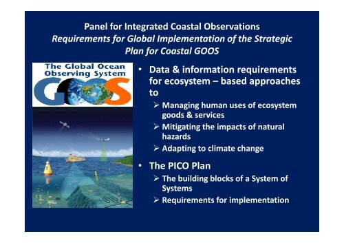
Panel for Integrated Coastal ObservationsRequirements for Global Implementation of the StrategicPlan for Coastal GOOS• Data & information requirementsfor ecosystem – based approachesto‣ Managing human uses of ecosystemgoods & services‣ Mitigating the impacts of naturalhazards‣ Adapting to climate change• The <strong>PICO</strong> Plan‣ The building blocks of a System ofSystems‣ Requirements for implementation
GSC‐III, 2000 (GOOS Report No. 87)• The broad area of concern [for COOP] extends from‣ semi‐enclosed systems in the coastal zone to‣ the continental shelf &‣ the deep ocean as appropriate• Changes in local ecosystems cannot be understood or anticipatedwithout‣ Observing & modeling large scale changes in the propagation of changeacross scales.‣ This calls for coordinated development of basin scale & coastal GOOSthrough a nested approach.2
Sustained Observations & ModelingCoastalGOOSHumanExpansionBasin ScaleGOOSIMPACTSMarine EcosystemGoods & ServicesIMPACTSClimate ChangeNatural HazardsMarine Operations3
Global Implementation of Coastal GOOSCoastal Ocean ObservationPanel (COOP)2005Panel for Integrated CoastalObservations (<strong>PICO</strong>)20112003Integrated DesignImplementationStrategyAction Plan forPhased Implementation4
Panel for Integrated Coastal Observations<strong>PICO</strong>• Paul DIGIACOMO (Co‐Chair), USANOAA‐NESDIS Center for Satellite Applications and Research• Jose MUELBERT (Co‐Chair), BrazilUniversidade Federal do Rio Grande, Instituto de Oceanografia• Tom MALONE, USAUMCES Horn Point Laboratory• John PARSLOW , AustraliaCSIRO Marine and Atmospheric Research• Neville SWEIJD, South AfricaNatural Resources & the Environment, Council for Scientific & IndustrialResearch• Helen YAP, PhilippinesUniversity of the Philippines , The Marine Science Institute5
The Plan• Identifies key indicators of pressures, states & impacts ofchanges in state for 7 priority Phenomena of Interest• Specifies end –to –end systems that are the building blocksfor a System of Systems• Identifies essential variables that should be monitored basedon these specifications• Describes the required infrastructure of the System of Systemsto monitor these variables & model changes in states• Recommends procedures for building the System of Systems6
Specify the Building Blocks of a System of Systems(1) Determine priority Phenomena of Interest (PoI)& Associated key indicators of ecosystem states(2) For each PoI‣ Identify user groups & determine their data &information requirements for products & applications‣ Identify key indicators of relevant pressures, states, &impacts of changes in states‣ Document observing system requirements• Observations (in situ & remote sensing)• Modeling & analysis• Reporting (real –time or delayed mode)• Data management & communications‣ Assess operational status & identify gaps7
ExampleEnd –to –End System for Indicators of Habitat Loss & Modification• Target coral reefs, seagrass beds,mangrove forests & salt marshes• Why?‣ Support high species diversity & livingmarine resources;‣ Prevent coastal erosion‣ Buffer coastal communities against stormsurges & flooding‣ Important carbon sinks (mangrove forestin particular)‣ Tourist attractions‣ Important indicators of the impacts of• ocean warming &• acidification (coral reefs in particular)88
Requirement Drivers – Products• Index of Vulnerability to Flooding‣ Digital, high resolution (≤ 1 km) maps of vulnerability toflooding updated at 1 –5 yr intervals depending on• Frequency & magnitude of flooding events &• Coastal geomorphology‣ Realistic scenarios for changes in vulnerability 5 –10 yr outbased on projections of• Sea level rise• Land –use practices• Coastal erosion• Loss & modification of biologically structured benthic habitats• Post –Event Water Quality Indicators‣ Digital maps & forecasts of water quality updated daily untilevent signature dissipates9
Data Requirements for ProductsIn Situ Measurements• Continuous‣ Sea level @ sentinel sites‣ Rain fall & river flows‣ Water temperature & salinity‣ Surface currents & wave fields• Post –event, daily‣ Distribution of water qualityparameters• Seasonally‣ Validate remote sensing of theextent of habitatsReporting• Near real time‣ Water quality parameters‣ Tides, river flows, rainfall,currents & waves• Delayed mode‣ Land – use/cover, flood zones‣ Habitat data‣ Bathymetry – topographyRemote Sensing• Continuous‣ Surface currents & wave fields‣ Sea surface temperature & salinity• Daily‣ Rain fall & river flows• Annually‣ Spatial distribution of habitatbuffers• Digital, high resolution maps @ 5 yrintervals‣ Land –use/cover‣ Flood zones‣ Near shore topography &bathymetry• During the event‣ Time –space extent of flooding• Post –event , daily‣ Temperature, salinity & chlorophyllfields‣ Validation 10
Model Requirements• High resolution digital elevation models of topography, shorelineposition & bathymetry• Algorithms to compute vulnerability as a function of‣ Current & predicted seasonal & annual mean sea level,‣ Near shore bathymetry – topography‣ Wave fields‣ Spatial distributions of ecological buffers‣ Spatial distribution of land use/cover• Coastal circulation –wave models• High resolution digital geospatial models (GIS) of levels ofvulnerability• Maps of water quality parameters‣ Temperature & salinity‣ Suspended sediments & Chlorophyll –a‣ Waterborne pathogens & chemical contaminants11
The Design Plan Calls forMulti –Scale Hierarchy of Observations & ModelsBasin ScaleModuleCoastalModuleGlobal CoastalNetwork (GCN)RegionalCoastal OceanObservingSystems12
Implementation Status of Coastal GOOS• RCOOSs are slowly being implemented by developed countries‣ Examples include• Integrated Marine Observing System – Australia• EuroGOOS & the Global Monitoring for Environmental Security –Europe• Integrated Ocean Observing System –USA‣ Global implementation of RCOOSs has been slow & uneven, especially inthe developing world;‣ The GCN exists in concept only;‣ Most operational systems are not part of an integrated systemof system, e.g.,• Global Coral Reef Monitoring Network• Continuous Plankton Recorder surveys• Fish stock assessments• Global Tracking Network• Problems‣ Insufficient sustained funding by developed countries for capacitybuilding in developing countries & emerging economies;‣ No international policies & procedures for establishing common standards& protocols;‣ Lack of international coordination mechanism for global implementation13
Accelerating the Delivery of Coastal GOOS• Establish a commission, or empower the GOOS Regional Council,to‣ Coordinate phased implementation on a global scale• Support national & international programs that‣ Target priority infrastructure for observations & predictions as setforth in the <strong>PICO</strong> plan• Establish data management & communications systems for‣ Interoperability & integration among monitoring systems & dataintegration within regions• Support sustained capacity building to‣ Fill priority spatial & temporal gaps in the Global Coastal Network indeveloping countries & emerging economies• Fund a regional demonstration projects at priority super sites14
The Next StepFormulate a ProposalCoralTriangle• International demonstrationproject‣ The super site:‣ Why?• Indonesian Archipelago‐South ChinaSea Region• Greatest number of pressures• Global epicenter of habitat & speciesdiversity• Sentinel sites for human pressures &state changes for all phenomena ofinterest• Regional networks are in place tofacilitate implementation15
Indonesian Archipelago‐South China Sea Regional Networks• Ocean Data and Information Network for the Western Pacific• The Southeast Regional GOOS (SEAGOOS)• Projects funded by The Global Environmental Facility‣ Reversing Environmental Degradation Trends in the South China Sea & Gulf ofThailand (UNEP)‣ West Pacific East Asia Oceanic Fisheries Management Project‣ Arafura & Timor Seas Ecosystem Action Program‣ Sulu‐Celebes Seas Sustainable Fisheries Management Project‣ Large Marine Ecosystem programs in the Gulf of Thailand, South China Sea & theIndonesian Sea• The East and Southeast Asia Biodiversity Information Initiative• The Coral Triangle Initiative on Coral Reefs, Fisheries & Food SecurityProject of Conservation International• Pacific Institutes of Marine Science (member of the World Association ofMarine Laboratories)16
Global Networks for Facilitating Expansion of GOOS to Include“Operational Ecology”• Institutional Networks‣ Partnership for Observation of the Global Oceans (<strong>POGO</strong>)‣ GOOS Regional Alliances (GRAs)‣ The World Association of Marine Stations (WAMS)‣ IOC‐IODE Ocean Data and Information Networks• Programmatic Networks‣ International network of Coral Reef Ecosystem Observing Systems (I‐CREOS)‣ Seagrass Net‣ Chlorophyll Globally Integrated Network (ChloroGIN)‣ Everyone’s Gliding Observatories (EGO)‣ GEO Biodiversity Observation Network (GEOBON)‣ Global Alliance of CPR Surveys (GACS)‣ Global Tracking Network (GTN) & Global Tagging of Pelagic Predators (GTOPP)‣ Regional Marine Instrument Centers (RMICs)‣ Global Terrestrial Network for River Discharge (GTN‐R)17
Conclusion (Knap)• A lot of effort has been put in to develop a plan• Developing a Global Coastal Network is a long wayoff but needs to start regionally• Its like “eating an elephant” The elephant willalways be there until you start eating it –it maytake 30 years but......• <strong>POGO</strong> labs will be important in developing thetechnologies, collecting and interpreting the dataand making the societal links in developing theGlobal Network.• Capacity building that <strong>POGO</strong> provides will beessential for this to be successful.18