classification of pleistocene deposits, new york city and vicinity
classification of pleistocene deposits, new york city and vicinity
classification of pleistocene deposits, new york city and vicinity

You also want an ePaper? Increase the reach of your titles
YUMPU automatically turns print PDFs into web optimized ePapers that Google loves.
Table 2. Proposed <strong>classification</strong> <strong>of</strong> Pleistocene <strong>deposits</strong> in southeastern New York <strong>and</strong> <strong>vicinity</strong>according to our interpretation that these <strong>deposits</strong> have resulted from 5 glacial invasions,assigned roman numerals counted down from the top.Because we lack evidence for assigning absolute ages to the products <strong>of</strong> these variousglacial episodes, the best we can do is count them down from the top. Accordingly, wedesignate each <strong>of</strong> the tills (<strong>and</strong> its formative glacier) by a roman numeral, starting with I, theyoungest, at the top, <strong>and</strong> ending with V, the oldest, at the bottom.In this paper we present some highlights <strong>of</strong> the bedrock underlying areas north <strong>and</strong> west<strong>of</strong> Long Isl<strong>and</strong> that have provided distinctive indicator stones to the Pleistocene <strong>deposits</strong> <strong>and</strong>outline the components <strong>of</strong> our proposed <strong>classification</strong>.HIGHLIGHTS OF BEDROCK UNDERLYING AREAS NORTHWEST AND NORTH OFLONG ISLANDThe bedrock underlying the regions to the northwest <strong>and</strong> north <strong>of</strong> Long Isl<strong>and</strong> containsvastly different assemblages including Proterozoic- to Paleozoic metamorphic rocks from thecentral parts <strong>of</strong> the Appalachians <strong>and</strong> Mesozoic sedimentary redbeds <strong>and</strong> intercalated maficigneous rocks that are remnants <strong>of</strong> the fillings <strong>of</strong> the Newark <strong>and</strong> Hartford basins, respectively.134
In addition, during the Cretaceous, coastal-plain strata, whose modern-day outcrop edge extendsacross NE New Jersey <strong>and</strong> is buried beneath the Pleistocene sediments <strong>of</strong> Long Isl<strong>and</strong>, extendedinl<strong>and</strong> for an unknown distance in southern New Engl<strong>and</strong>. Although NW <strong>and</strong> N <strong>of</strong> the outcropedge, most <strong>of</strong> the onlapping coastal-plain strata have been eroded, remnants are present locally atthe surface <strong>and</strong> are well known in the subsurface <strong>of</strong> New York City <strong>and</strong> <strong>vicinity</strong>.Together, the crystalline metamorphic rocks underlying the region <strong>of</strong> interest consist <strong>of</strong>sillimanite- <strong>and</strong> kyanite-grade Proterozoic- to Lower Paleozoic rocks, including gneiss, quartzite,marble, schist, <strong>and</strong> amphibolite (Baskerville, 1992, 1994; Rodgers, 1985; Drake <strong>and</strong> others,1996). Distinctive igneous rocks <strong>of</strong> Late Ordovician age are present, notably in the Cortl<strong>and</strong>tComplex near Peekskill, Westchester Co., NY (Ratcliffe, 1981; Ratcliffe, Bender, <strong>and</strong> Tracy,1983).Two bodies <strong>of</strong> Mesozoic-age strata nonconformably overlie these deformed crystallinebasementrocks (Fig. 3). The Mesozoic rocks (<strong>of</strong> Late Triassic-Early Jurassic ages, Olsen, 1978;Froelich <strong>and</strong> Olsen, 1985; Lyttle <strong>and</strong> Epstein, 1987) consist predominantly red-coloredsedimentary strata but include intercalated sheets <strong>of</strong> both intrusive-<strong>and</strong> extrusive dark bluishgraymafic igneous rocks whose fresh color is masked by a thin limonitic coating from theoxidation <strong>of</strong> thin film <strong>of</strong> joint-facing pyrite <strong>and</strong> whose textures range from that <strong>of</strong> basalt to that<strong>of</strong> pegmatitic gabbro.West <strong>of</strong> the Hudson River, from Stony Point, Rockl<strong>and</strong> Co., NY, south to Staten Isl<strong>and</strong><strong>and</strong> beyond, is the type area <strong>of</strong> the Newark Supergroup (Froelich <strong>and</strong> Olsen, 1985). Here, thestrata dip predominantly to the NW, usually at angles <strong>of</strong> about 15° or less (Lyttle <strong>and</strong> Epstein,1987). The tilted <strong>and</strong> eroded edge <strong>of</strong> the sheet <strong>of</strong> resistant intrusive rock near the base <strong>of</strong> thesedimentary strata forms the Palisades ridge. Comparable tilted, eroded edges <strong>of</strong> sheets <strong>of</strong>resistant volcanic rocks that are intercalated high up in the stratigraphic succession form theWatchung ridges <strong>of</strong> north-central New Jersey.The Mesozoic sedimentary <strong>and</strong> igneous rocks filling the Hartford Basin underlie a northsouth-trendinglowl<strong>and</strong> in the central part <strong>of</strong> Connecticut that continues northward intoMassachusetts. The strata composing the filling the Hartford basin show many similarities withthose filling the Newark basin in New Jersey <strong>and</strong> adjacent Pennsylvania (S<strong>and</strong>ers, 1963). Bothconsist predominantly <strong>of</strong> red-colored sedimentary rocks <strong>and</strong> intercalated sheets <strong>of</strong> mafic igneousrocks both intrusive <strong>and</strong> extrusive. In contrast with the Newark basin, the regional dip <strong>of</strong> thepreserved remnants <strong>of</strong> the Hartford basin-filling strata is to the E. The tilted edge <strong>of</strong> the resistantintrusive sheet near the base <strong>of</strong> the Mesozoic rocks in the central Connecticut belt forms WestRock. The Connecticut equivalents <strong>of</strong> the Watchung extrusives are the volcanic rocks <strong>of</strong> theTalcott, Holyoke, <strong>and</strong> Hampden basalts. These underlie curvilinear ridges that are near the top<strong>of</strong> the preserved sedimentary strata in southern CT, but are present near the middle <strong>of</strong> thesuccession in central CT.135
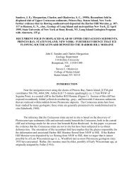
Figure 3. Regional sketch map <strong>of</strong> part <strong>of</strong> NE USA showing locations <strong>of</strong> preserved remnants <strong>of</strong>strata that filled Mesozoic nonmarine basins (Newark basin in NY, NJ, <strong>and</strong> PA; Hartford basinin CT <strong>and</strong> MA; light gray tone). Parallel line segments show how glacial ice flowing regionallyfrom each <strong>of</strong> the observed dominant directions would distribute diagnostic erratics to LongIsl<strong>and</strong>. P = Peekskill, NY, near unique Cortl<strong>and</strong>t Complex <strong>of</strong> coarse ultramafic igneous rocks.(Base map from J. E. S<strong>and</strong>ers, 1963, fig. 7, p. 513.)A. Flow from NNW to SSE <strong>deposits</strong> reddish-brown till <strong>and</strong> erratics <strong>of</strong> Mesozoic rocks inextreme W <strong>and</strong> extreme E Long Isl<strong>and</strong>, but throughout a substantial stretch along the N shore <strong>of</strong>Long Isl<strong>and</strong>, downflow from the "crystalline corridor" between the two belts <strong>of</strong> Mesozoic rocks,did not deposit any reddish-brown till. The distribution <strong>of</strong> erratics in the Harbor Hill Moraine<strong>and</strong> in the Ronkonkoma Moraine proves these moraines were deposited by ice flow from NNWto SSE, as shown in Fig. 2.B. Flow from NNE to SSW, as in the "Woodfordian" glacier, distributes erratics fromthe Hartford basin to the SSW. The absence <strong>of</strong> reddish-brown till <strong>and</strong> associated Mesozoicerratics in the Pleistocene <strong>deposits</strong> exposed along the N shore <strong>of</strong> Long Isl<strong>and</strong> WSW <strong>of</strong> the S end<strong>of</strong> the Hartford basin proves that the "Woodfordian" ice could not have deposited the mainbodies <strong>of</strong> Long Isl<strong>and</strong>'s two famous terminal-moraine ridges.The distinctive colors <strong>and</strong> compositions <strong>of</strong> the Mesozoic rocks make them ideal indicatorstones <strong>and</strong> pigments for distinctive reddish-brown tills. However, by themselves, erratics fromthe Newark basin cannot be distinguished from those from the Hartford basin. At least locally,however, the associated non-Mesozoic rocks provide useful diagnostic clues. For example, lowgradephyllites, -schist, <strong>and</strong> -metavolcanic rocks containing chlorite <strong>and</strong> epidote are present inthe western Connecticut terrane W <strong>of</strong> the S end <strong>of</strong> the Hartford basin (Fritts, 1962; Burger,1967). No such low-grade rocks <strong>of</strong> volcaniclastic parentage are present in the <strong>vicinity</strong> <strong>of</strong> theNewark Basin <strong>of</strong> New Jersey. Therefore, erratics <strong>of</strong> such low-grade volcaniclastic rocksassociated with distinctive Mesozoic rocks would uniquely identify a Connecticut source.COMPONENTS OF OUR PROPOSED CLASSIFICATION136
OF PLEISTOCENE DEPOSITSAs mentioned, from our previous work (summarized in S<strong>and</strong>ers <strong>and</strong> Merguerian, 1997)we know that in New York City, glacial sediments deposited by ice flowing from NNW to SSE(across the Hudson Valley) are characterized by their distinctive reddish-brown-color, the result<strong>of</strong> a glacier's grinding over hematite-rich sedimentary rocks from the Newark Basin. Bycontrast, sediments deposited by glaciers that flowed from the NNE to the SSW (down theHudson Valley) are associated with yellow-brown- to brownish-gray tills, the result <strong>of</strong> glacialscour <strong>of</strong> non-hematite-bearing rocks underlying the "crystalline corridor" <strong>of</strong> metamorphic rocksexposed between the Newark- <strong>and</strong> Hartford basins. Each <strong>of</strong> the flow directions resulted in asystem <strong>of</strong> crosscutting glacial features <strong>and</strong> diagnostic indicator stones, easily identifiable in thefield.According to us, Glacier I flowed from NNE to SSW <strong>and</strong> did not reach most <strong>of</strong> LongIsl<strong>and</strong>; it deposited the fields <strong>of</strong> drumlins in Rockl<strong>and</strong> County, NY <strong>and</strong> the yellowish-brown tillforming a single drumlin at Enoch's Nose, Croton Point Park, Westchester County, NY; theHamden Till in south-central Connecticut (Flint, 1961); <strong>and</strong> a terminal moraine along the S coast<strong>of</strong> Connecticut [SW <strong>of</strong> the Norwalk Isl<strong>and</strong>s (Ellis, 1962), it crossed what is now Long Isl<strong>and</strong>Sound <strong>and</strong> covered Queens (Woodworth, 1901; Brooklyn (Lyell, 1852), <strong>and</strong> at least some <strong>of</strong>Staten Isl<strong>and</strong>]. Based on evidence from the Catskills (Rich, 1935), we can infer that the"Woodfordian" glacier was thinner than most, if not all, <strong>of</strong> its predecessors (top at alt. 3900 ft vs.ice thick enough to cover all <strong>of</strong> the Catskills <strong>and</strong> all other high parts <strong>of</strong> New Engl<strong>and</strong>). Apossible Glacier I/II interglacial deposit is the paleosol capping the reddish-brown till in thecoastal bluffs <strong>of</strong> SW Staten Isl<strong>and</strong>.Glacier II, flowing from NNW to SSE, reached all <strong>of</strong> Long Isl<strong>and</strong> <strong>and</strong> deposited theHarbor Hill Moraine <strong>and</strong> reddish-brown till at Croton Point Park <strong>and</strong> other localities on the Eside <strong>of</strong> the Hudson River in Westchester County <strong>and</strong> New York City; <strong>and</strong> possibly also the LakeChamberlain Till <strong>of</strong> south-central Connecticut (Flint, 1961). Glacier II/III interglacial marginalmarinesediments include the Wantagh Formation <strong>of</strong> the Jones Beach subsurface [Rampino(1978 ms.); Rampino <strong>and</strong> S<strong>and</strong>ers (1981)].Glacier III, the most-extensive <strong>of</strong> them all, also flowed from NNW to SSE <strong>and</strong> featuredthree fluctuations; its earliest advance deposited a now-vanished <strong>and</strong> -submerged terminalmoraine; the ice front then retreated <strong>and</strong> a regionally extensive proglacial Lake Long Isl<strong>and</strong>formed in which the lacustrine sediments forming the lower member <strong>of</strong> Fuller's ManhassetFormation were deposited; a subsequent readvance deposited the Montauk Till; <strong>and</strong> after anotherretreat <strong>and</strong> deposition <strong>of</strong> outwash sediments, a final readvance deposited the RonkonkomaMoraine. Glacier III/IV interglacial <strong>deposits</strong> include the Gardiners Clay.Glacier II <strong>and</strong>/or Glacier III (we do not know which; it could have been both) broughtanthracite erratics from NE Pennsylvania into the New York City region. Such ice flow explainsthe results that Zen <strong>and</strong> Mamay (1968), who accepted the consensus view <strong>of</strong> only a singledirection <strong>of</strong> Pleistocene ice flow from the NNE to the SSW, found so puzzling.137
Glacier IV flowed from the NNE to the SSW, deposited a gray-brown till exposed atwater's edge, Teller's Point, Croton Point Park <strong>and</strong> in the lower part <strong>of</strong> the coastal bluff at TargetRock National Wildlife Refuge, Long Isl<strong>and</strong>; <strong>and</strong> sculpted many rock exposures in the HudsonHighl<strong>and</strong>s, in northern Manhattan, <strong>and</strong> in the New York Botanical Garden <strong>and</strong> sculpted the rochemoutonnée structure at the N end <strong>of</strong> Pelham Bay Park, both in The Bronx. We have not foundany Glacier IV/V interglacial <strong>deposits</strong>.Glacier V flowed from NNW to SSE <strong>and</strong> deposited the much-decomposed reddishbrowntills resting on the Upper Cretaceous coastal-plain strata at the AKR ExcavatingCompany, SW Staten Isl<strong>and</strong>, <strong>and</strong> at Garvies Point, Long Isl<strong>and</strong>.CONCLUSIONSThe main bodies <strong>of</strong> Long Isl<strong>and</strong>'s two famous terminal moraines contain unmistakableprovenance evidence that they were deposited by ice that flowed regionally from NNW to SSE.Because the "Woodfordian" glacier, our No. I, is the glacier most geologists accept as beingresponsible for these two moraines, flowed from NNE to SSW <strong>and</strong> stopped along the S coast <strong>of</strong>CT; it reached only westernmost Long Isl<strong>and</strong> (Queens <strong>and</strong> Brooklyn) <strong>and</strong> adjacent parts <strong>of</strong>Staten Isl<strong>and</strong>. Accordingly, the main body <strong>of</strong> the Harbor Hill Moraine could not have beendeposited by the "Woodfordian" glacier but rather must have been deposited by ice flowingfrom NNW to SSE. We think the glacier responsible for depositing the main body <strong>of</strong> the HarborHill Moraine was our No. II (<strong>of</strong> probable Early Wisconsinan age, as Fuller believed). Thesubsurface Wantagh Formation, a marginal-marine deposit, may be <strong>of</strong> Sangamonian age. Themost-extensive local Pleistocene unit is Fuller's Manhasset Formation, which is probably <strong>of</strong>Illinoian age. It consists <strong>of</strong> two <strong>deposits</strong> <strong>of</strong> large proglacial lakes separated by the Montauk Till(our units IIIA, IIIB, <strong>and</strong> IIIC). We conclude that a terminal moraine <strong>of</strong> pre-Ronkonkoma age(deposited by our Glacier IIIC), which we correlate with the Martha's Vineyard-Nantucketmoraines <strong>and</strong> bouldery shoals in between, served as the dam to impound Proglacial Lake LongIsl<strong>and</strong> in which the lacustrine parts <strong>of</strong> the Manhasset Formation were deposited. We acceptWehmiller's finding that the Gardiners Clay is <strong>of</strong> Yarmouthian age (as assigned by Fuller) <strong>and</strong>not <strong>of</strong> Sangamonian age as supposed by MacClintock <strong>and</strong> Richards (1936) <strong>and</strong> their host <strong>of</strong>followers. The ages <strong>of</strong> two pre-"Illinoian" tills (our Nos. IV <strong>and</strong> V) that contain much-decayedstones are not well constrained. We guesstimate their assignments as "Kansan"(?) <strong>and</strong>"Nebraskan"(?), respectively.ACKNOWLEDGEMENTSOur continued studies <strong>of</strong> the glacial geology <strong>of</strong> the New York City area have beensupported by the Geology Department <strong>of</strong> H<strong>of</strong>stra University. We are indebted to our colleaguePr<strong>of</strong>. J Bret Bennington for his interest <strong>and</strong> observations made on several joint field trips.138
REFERENCES CITEDBaskerville, C. A., 1992, Bedrock (sic) <strong>and</strong> engineering geologic (sic) maps <strong>of</strong> Bronx County <strong>and</strong> parts <strong>of</strong> New York <strong>and</strong> Queens counties, NewYork: U. S. Geological Survey Miscellaneous Investigations Series Map I-2003 (scale 1:24,000).Baskerville, C. A., 1994, Bedrock (sic) <strong>and</strong> engineering geology maps <strong>of</strong> New York County <strong>and</strong> parts <strong>of</strong> Kings <strong>and</strong> Queens counties, New York<strong>and</strong> parts <strong>of</strong> Bergen <strong>and</strong> Hudson counties, New Jersey: U. S. Geological Survey Miscellaneous Investigations Series Map I-2306 (2 sheets;colored maps on scale <strong>of</strong> 1/24,000).Burger, H. R., III, 1967, Stratigraphy <strong>and</strong> structure <strong>of</strong> the western part <strong>of</strong> the New Haven quadrangle, Connecticut: Connecticut Geological <strong>and</strong>Natural History Survey Report <strong>of</strong> Investigations 4, 15 p. (geologic map on scale <strong>of</strong> 1/57,600).Cadwell, D. H., ed., 1986, The Wisconsinan Stage <strong>of</strong> the First Geological District, eastern New York: New York State Museum, Bulletin 455,191 p.Cadwell, D. H., 1989, Surficial geology map <strong>of</strong> New York, Lower Hudson sheet: New York State Museum Map <strong>and</strong> Chart Series 40, scale1:250,000.Chamberlin, T. C., 1883, Preliminary paper on the terminal moraine <strong>of</strong> the second glacial epoch, p. 291-402 in United States Geological SurveyAnnual Report, 3rd (1881-1882), 564 p. (1843-1928)Chamberlin, T. C., 1888, The rock scorings <strong>of</strong> the great Ice Age: U. S. Geological Survey Annual Report, 7th (1885-1886), p. 147-248.Chamberlin, T. C., 1895a, The <strong>classification</strong> <strong>of</strong> American glacial <strong>deposits</strong>: Journal <strong>of</strong> Geology, v. 3, p. 270-277.Chamberlin, T. C., 1895b, Glacial phenomena <strong>of</strong> North America, p. 724-775 in Geikie, James, The great ice age: New York, D. Appleton <strong>and</strong>Company, 000 p.Clapp, F. G., 1908, Complexity <strong>of</strong> the glacial period in northeastern New Engl<strong>and</strong>: Geological Society <strong>of</strong> America Bulletin, v. 18, p. 505-556.Crosby, W. O., 1890, Geological history <strong>of</strong> the Boston basin [Mass.]: Boston Society <strong>of</strong> Natural History Proceedings, v. 25, p. 10-17.Crosby, W. O., 1891, Composition <strong>of</strong> the till or boulder clay: Boston Society <strong>of</strong> Natural History Proceedings, v. 25, p. 115-140.Drake, A. A., Volkert, R. A., Monteverde, D. H., Herman, G. C., Houghton, H. F., Parker, R. A., <strong>and</strong> Dalton, R. F., 1996, Bedrock geologic map<strong>of</strong> northern New Jersey: U. S. Geological Survey Miscellaneous Map Investigations I-2540-A (colored geologic map in 2 sheets, scale1/100,000).Ellis, C. W., 1962, Marine sedimentary environments in the <strong>vicinity</strong> <strong>of</strong> the Norwalk Isl<strong>and</strong>s, Connecticut: Connecticut Geological <strong>and</strong> NaturalHistory Survey Bulletin 94, 89 p.Fleming, W. L. S., 1935, Glacial geology <strong>of</strong> central Long Isl<strong>and</strong>: American Journal <strong>of</strong> Science, 5th series, v. 30, p. 216-238.Flint, R. F., 1935, How many glacial stages are recorded in New Engl<strong>and</strong>?: Journal <strong>of</strong> Geology, v. 43, p. 771-777.Flint, R. F., 1945, Glacial map <strong>of</strong> North America: Geological Society <strong>of</strong> America Special Papers No. 60, 37 p.Flint, R. F., 1961, Two tills in southern Connecticut: Geological Society <strong>of</strong> America Bulletin, v. 72, no. 11, p. 1687-1691.Flint, R. F., <strong>and</strong> Gebert, J. A., 1976, Latest Laurentide ice sheet: <strong>new</strong> evidence from southern New Engl<strong>and</strong>: Geological Society <strong>of</strong> AmericaBulletin, v. 87, no. 2, p. 182-188.Fritts, C. E., 1962, Age (sic) <strong>and</strong> sequence <strong>of</strong> metasedimentary (sic) <strong>and</strong> metavolcanic formations northwest <strong>of</strong> New Haven Connecticut: U. S.Geological Survey Pr<strong>of</strong>essional Paper 450-D, p. D32-D36.Froelich, A. J., <strong>and</strong> Olsen, P. E., 1985, 1. Newark Supergroup, a revision <strong>of</strong> the Newark Group in eastern North America, p. 1-3 in Robinson, G.R., <strong>and</strong> Froelich, A. J., eds., U. S. Geological Survey workshop on the Early Mesozoic basins <strong>of</strong> the eastern United States, Second, Proceedings:U. S. Geological Survey Circular 946, 147 p.Fuller, M. L., 1901, Probable representatives <strong>of</strong> pre-Wisconsin till in southeastern Massachusetts: Journal <strong>of</strong> Geology, v. 9, p. 311-329.Fuller, M. L., 1903, Probable pre-Kansan <strong>and</strong> Iowan <strong>deposits</strong> <strong>of</strong> Long Isl<strong>and</strong>: American Geologist, v. 32, p. 308-312.Fuller, M. L., 1905, Geology <strong>of</strong> Fishers Isl<strong>and</strong>, New York: Geological Society <strong>of</strong> America Bulletin, v. 16, p. 367-390. [Gardiner (sic; no s tomake Gardiners) clay on 375-378]139
Fuller, M. L., 1906, Glacial stages in southeastern New Engl<strong>and</strong> <strong>and</strong> <strong>vicinity</strong>: Science, <strong>new</strong> series, v. 24, p. 467-469. considers that the till atBrockton is pre-Kansan; that the Boston drumlins are composed <strong>of</strong> Illinoian till, <strong>and</strong> the thin surficial till is the Wisconsin (total: 3).Fuller, M. L., 1914, The geology <strong>of</strong> Long Isl<strong>and</strong>, New York: U. S. Geological Survey Pr<strong>of</strong>essional Paper 82, 223 p.Fuller, M. L., 1937, Comment on: "Correlation <strong>of</strong> Late (sic) Pleistocene marine (sic) <strong>and</strong> glacial <strong>deposits</strong> <strong>of</strong> New Jersey <strong>and</strong> New York:"Geological Society <strong>of</strong> America Bulletin, v. 47 Supplement, p. 1982-1994.Gilbert, G. K., 1885, The topographic features <strong>of</strong> lake shores, p. 69-123 in U. S. Geological Survey, Annual Report, 5th (1883-1884), 469 p.Gilbert, G. K., 1890, Lake Bonneville: U. S. Geological Survey, Monograph 1, 438 p.Goldsmith, Richard, 1960, A post Harbor Hill-Charlestown moraine in southeastern Connecticut: American Journal <strong>of</strong> Science, v. 258, p. 740-743.Isachsen, Y. W.; L<strong>and</strong>ing, Ed; Lauber, J. M.; Rickard, L. V.; <strong>and</strong> Rogers, W. B., eds., 1991, Geology <strong>of</strong> New York. A simplified account: NewYork State Museum <strong>and</strong> Science Service Educational Leaflet 20, 284 p.Kaye, C. A., 1964a, Boulder train <strong>of</strong> silicified Paleozoic wood, southeastern Massachusetts: Geological Society <strong>of</strong> America Bulletin, v. 75, no. 3,p. 233-236.Kaye, C. A., 1964b, Outline <strong>of</strong> Pleistocene geology <strong>of</strong> Martha's Vineyard, Massachusetts: United States Geological Survey Pr<strong>of</strong>essional Paper501-C, p. C134-C139.Kaye, C. A., 1964c, Illinoian <strong>and</strong> early Wisconsin moraines <strong>of</strong> Martha's Vineyard, Massachusetts: United States Geological Survey Pr<strong>of</strong>essionalPaper 501-C, p. C140-C143.Kaye, C. A., 1964d, The Pleistocene geology <strong>of</strong> Martha's Vineyard, Massachusetts: Itinerary for the Friends <strong>of</strong> the Pleistocene Annual Reunion,27th: U. S. Geological Survey Open-File Report.Kaye, C. A., 1976, The geology (sic) <strong>and</strong> early history <strong>of</strong> the Boston, Massachusetts area--a bicentennial approach: United States GeologicalSurvey Bulletin 1476, 78 p.Kaye, C. A., 1982, Bedrock (sic) <strong>and</strong> Quaternary geology <strong>of</strong> the Boston area, Massachusetts, p. 25-40 in Legget, R. F., ed., Geology under cities:Boulder, Colorado, The Geological Society <strong>of</strong> America, Reviews in Engineering Geology, v. 5, 131 p.Koteff, Carl; Oldale, R. N.; <strong>and</strong> Hartshorn, J. H., 1967, Geologic map <strong>of</strong> the North Truro quadrangle, Barnstable County, Massachusetts: U. S.Geological Survey Geologic Quadrangle Map GQ-599, scale 1/24,000.Lyell, Sir Charles, 1852, Travels in North America, in the years 1841-2; with geological observations on the United States, Canada, <strong>and</strong> NovaScotia: New York, NY, John Wiley, 2 volumes. (v. 1, 251 p,; v, 2, 197 p.)(according to Muller, 1965, p. 48, the date is 1845 <strong>and</strong> 221 p in v. 2)Lyttle, P. T., <strong>and</strong> Epstein, J. B., 1987, Geologic map <strong>of</strong> the Newark 1° by 2° quadrangle, New Jersey, Pennsylvania, <strong>and</strong> New York: UnitedStates Geological Survey Miscellaneous Investigations Series Maps, Map I-1715 (2 sheets; scale 1:250,000).MacClintock, Paul; <strong>and</strong> Richards, H. G., 1936, Correlation <strong>of</strong> the late (sic) Pleistocene marine (sic) <strong>and</strong> glacial <strong>deposits</strong> <strong>of</strong> New Jersey <strong>and</strong> NewYork: Geological Society <strong>of</strong> America Bulletin, v. 47, no. 3, p. 289-338.MacClintock, Paul; <strong>and</strong> Richards, H. G., 1937, Correlation <strong>of</strong> the late (sic) Pleistocene marine (sic) <strong>and</strong> glacial <strong>deposits</strong> <strong>of</strong> New Jersey <strong>and</strong> NewYork (reply to Discussion by M. L. Fuller): Geological Society <strong>of</strong> America Bulletin, v. 47 Supplement, p. 1982-1994.Muller, E. H., 1964, Quaternary geology <strong>of</strong> New York, p. 99-112 in Wright, H. E., <strong>and</strong> Frey, D. G., eds., The Quaternary <strong>of</strong> the United States:Princeton, NJ, Princeton University Press, 922 p.Muller, E. H., <strong>and</strong> Calkin, P. E., 1993, Timing <strong>of</strong> Pleistocene glacial events in New York State: Canadian Journal <strong>of</strong> Earth Sciences, v. 30, p.1829-1845.Muller, E. H.; Sirkin, Les; <strong>and</strong> Craft, J. L., 1993, Stratigraphic evidence <strong>of</strong> a pre-Wisconsinan interglaciation in the Adirondack Mountains, NewYork: Quaternary Research, v. 40, p. 163-138.Newman, W. A., <strong>and</strong> Mickelson, D. M., 1994, Genesis <strong>of</strong> Boston Harbor drumlins, Massachusetts, p. 333-343 in Dardis, G. F., <strong>and</strong> McCabe, A.M., eds., Subglacial processes, sediments (sic) <strong>and</strong> l<strong>and</strong>forms (sic): Symposium, University <strong>of</strong> Ulster, July 1992: Sedimentary Geology, v. 91,nos. 1-4 (special volume), 382 p.Oldale, R. N., 1982, Pleistocene stratigraphy <strong>of</strong> Nantucket, Martha's Vineyard, The Elizabeth Isl<strong>and</strong>s, <strong>and</strong> Cape Cod, Massachusetts, p. 1-34 inLarson, G. J., <strong>and</strong> Stone, B. D., eds., Late Wisconsinan glaciation <strong>of</strong> New Engl<strong>and</strong>. Proceedings <strong>of</strong> a symposium held at Northeastern section <strong>of</strong>Geological Society <strong>of</strong> America, 13 March 1980, Philadelphia, PA. Dubuque, Iowa, Kendall/Hunt Publishing Company, 242 p.140
Oldale, R. N., <strong>and</strong> Colman, S. M., 1992, On the age <strong>of</strong> the penultimate full glaciation <strong>of</strong> New Engl<strong>and</strong>, p. 163-170 in Clark, P. U., <strong>and</strong> Lea, P. D.,eds., The last Interglacial-Glacial transition in North America: Boulder, CO, Geological Society <strong>of</strong> America Special Paper 270, 317 p.Oldale, R. N., <strong>and</strong> Eskenasy, D. M., 1983, Regional significance <strong>of</strong> pre-Wisconsin till from Nantucket Isl<strong>and</strong>, Massachusetts: QuaternaryResearch, v. 19, p. 302-311.Oldale, R. N., Valentine, P. C., Cronin, T. M., Spiker, E. C., Blackwelder, B. W., Belknap, D. F., Wehmiller, J. F., <strong>and</strong> Szabo, B. J., 1982,Stratigraphy (sic), structure (sic), absolute age (sic), <strong>and</strong> paleontology <strong>of</strong> the upper Pleistocene <strong>deposits</strong> at Sankaty Head, Nantucket Isl<strong>and</strong>,Massachusetts: Geology, v. 10, no. 5, p. 246-252.Olsen, P. E., 1978, On the use <strong>of</strong> the term Newark for Triassic <strong>and</strong> Early (sic) Jurassic rocks <strong>of</strong> eastern North America: Newsletters Stratigraphy,v. 7, no. 2, p. 90-95.Pessl, Fred, Jr., 1966, A two-till locality in northeastern Connecticut: U. S. Geological Survey Pr<strong>of</strong>essional Paper 550-D, P. D89-D93.Pessl, Fred, Jr.; <strong>and</strong> Schafer, J. P., 1968, Two-till problem in Naugatuck-Torrington area, western Connecticut, Trip B-1. p. B1-B25 in Orville, P.M., ed., Guidebook for field trips in Connecticut: New Engl<strong>and</strong> Intercollegiate Geological Conference Annual Meeting, 62nd, New Haven,Connecticut: Hartford, CT, Connecticut Geological <strong>and</strong> Natural History Survey Guidebook No. 2, not consecutively paginated.Rampino, M. R., 1978 ms., Quaternary history <strong>of</strong> south-central Long Isl<strong>and</strong>, New York: New York, New York, Columbia University,Department <strong>of</strong> Geological Sciences, Ph. D. Dissertation, 742 p.Rampino, M. R., <strong>and</strong> S<strong>and</strong>ers, J. E., 1981, Upper Quaternary stratigraphy <strong>of</strong> southern Long Isl<strong>and</strong>, New York: Northeastern Geology, v. 3, no. 2,p. 116-128.Ratcliffe, N. M., 1981, Cortl<strong>and</strong>t-Beemerville magmatic belt: a probable late Taconian alkalic cross trend in the central Appalachians: Geology,v. 9, no. 7, p. 329-335.Ratcliffe, N. M., Bender, J. F., <strong>and</strong> Tracy, R. J., 1983, Tectonic setting (sic), chemical petrology (sic) <strong>and</strong> petrogenesis <strong>of</strong> the Cortl<strong>and</strong>t Complex<strong>and</strong> related igneous rocks <strong>of</strong> southeastern New York State: Geological Society <strong>of</strong> America Northeastern Section Meeting, 23-26 March 1983,Concord Hotel, Kiamesha Lake, NY, Guidebook for Field Trip 1, 101 p.Rich, J. L., 1935, Glacial geology <strong>of</strong> the Catskills: New York State Museum Bulletin No. 299, 180 p.Ricketts, H. C., 1986, Examination in boreholes <strong>of</strong> the subsurface Gardiners Clay (Pleistocene), in the context <strong>of</strong> the Cretaceous-Quaternarysection <strong>of</strong> Great Neck, Long Isl<strong>and</strong>, New York: Northeastern Geology, v. 8, nos. 1/2, p. 13-22.Rodgers, John, 1985, Bedrock geological map <strong>of</strong> Connecticut: Hartford, CT, Connecticut Geological <strong>and</strong> Natural History Survey, ConnecticutNatural Resources Atlas Series, scale 1:250,000.Salisbury, R. D., assisted by H. B. Kümmel, C. E. Peet, <strong>and</strong> G. N. Knapp, 1902, The glacial geology <strong>of</strong> New Jersey: Geological Survey <strong>of</strong> NewJersey, Final Report <strong>of</strong> the State Geologist, v. 5: Trenton, New Jersey, MacCrellish <strong>and</strong> Quigley, Book <strong>and</strong> Job Printers, 802 p.Salisbury, R. D., <strong>and</strong> Peet, C. E., 1894, Section V. Drift phenomena <strong>of</strong> the Palisade ridge, p. 157-224 in New Jersey State Geologist AnnualReport for 1893: Trenton, NJ, The John L. Murphy Publishing Company Printers, 457 p.S<strong>and</strong>ers, J. E., 1963, Late Triassic tectonic history <strong>of</strong> northeastern United States: American Journal <strong>of</strong> Science, v. 261, p. 501-524.S<strong>and</strong>ers, J. E., 1974, Geomorphology <strong>of</strong> the Hudson Estuary, p. 5-38 in Roels, Oswald, ed., Hudson River Colloquium: New York Academy <strong>of</strong>Sciences Annals, v. 250, 185 p.S<strong>and</strong>ers, J. E.; <strong>and</strong> Merguerian, Charles, 1991, Pleistocene geology <strong>of</strong> Long Isl<strong>and</strong>'s north shore: S<strong>and</strong>s Point <strong>and</strong> Garvies Point to Target Rock:Long Isl<strong>and</strong> Geologists' Association Field Trip 29 June 1991 Guidebook: Hempstead, NY, H<strong>of</strong>stra University Department <strong>of</strong> Geology, 40 p.S<strong>and</strong>ers, J. E.; <strong>and</strong> Merguerian, Charles, 1994a, Fitting <strong>new</strong>ly discovered north-shore Gilbert-type lacustrine deltas into a revised Pleistocenechronology <strong>of</strong> Long Isl<strong>and</strong> (extended abstract), p. 103-113 in Hanson, G. N., chm., Geology <strong>of</strong> Long Isl<strong>and</strong> <strong>and</strong> metropolitan New York, 23 April1994, Stony Brook, NY: Stony Brook, NY, Long Isl<strong>and</strong> Geologists Program with Abstracts, 165 p.S<strong>and</strong>ers, J. E.; <strong>and</strong> Merguerian, Charles, 1994b, Glacial geology <strong>of</strong> the New York City region, p. 93-200 in Benim<strong>of</strong>f, A. I., ed., The geology <strong>of</strong>Staten Isl<strong>and</strong>, New York: Geological Association <strong>of</strong> New Jersey Annual Meeting, 11th, Somerset, NJ, 14-15 October 1994, Field guide <strong>and</strong>proceedings, 296 p.S<strong>and</strong>ers, J. E.; <strong>and</strong> Merguerian, Charles, 1995, Evidence for pre-Woodfordian ages <strong>of</strong> Long Isl<strong>and</strong>'s terminal moraines, p. 91-106 in Hanson, G.N., chm., Geology <strong>of</strong> Long Isl<strong>and</strong> <strong>and</strong> metropolitan New York, 22 April 1995, Stony Brook, NY: Stony Brook, NY, Long Isl<strong>and</strong> GeologistsProgram with Abstracts, 135 p.S<strong>and</strong>ers, J. E.; <strong>and</strong> Merguerian, Charles, 1996, Trip 39: Glacial geology <strong>of</strong> Long Isl<strong>and</strong>, 01-02 June 1996 (revision <strong>of</strong> Trip 15, 17-18 November1990): New York Academy <strong>of</strong> Sciences Section <strong>of</strong> Geological Sciences Trips on the Rocks Guidebook, 129 p.141
S<strong>and</strong>ers, J. E.; <strong>and</strong> Merguerian, Charles, 1997, Geologic setting <strong>of</strong> a cruise from the mouth <strong>of</strong> the East River to the George Washington bridge,New York Harbor: New York, NY, American Rock Mechanics Association, NYRocks 97, hosted by Columbia University Field-Trip Guidebook,147 p.S<strong>and</strong>ers, J. E.; Merguerian, Charles; <strong>and</strong> Mills, H. C., 1993, "Port Washington deltas" <strong>of</strong> Woodworth (1901) revisited: pre-Woodfordian Gilberttypedeltas revealed in storm-eroded coastal bluff, S<strong>and</strong>s Point, New York (abstract): Geological Society <strong>of</strong> America Abstracts with Programs, v.25, no. 6, p. A-308.S<strong>and</strong>ers, J. E.; Merguerian, Charles; <strong>and</strong> Okulewicz, S. C., 1995, Recumbent fold in displaced slab <strong>of</strong> Upper Cretaceous sediments, Princes Bay,Staten Isl<strong>and</strong>, New York: Further evidence that ice flowing southeastward deposited the Harbor Hill Moraine (extended abstract), p. 107-117 inHanson, G. N., chm., Geology <strong>of</strong> Long Isl<strong>and</strong> <strong>and</strong> metropolitan New York, 22 April 1995, Stony Brook, NY: Stony Brook, NY, Long Isl<strong>and</strong>Geologists Program with Abstracts, 135 p.Seyfert, C. K., <strong>and</strong> Leveson, D. J., 1968, Structure (sic) <strong>and</strong> petrology <strong>of</strong> Pelham Bay Park, p. 175-195 in Finks, R. M., ed., New York StateGeological Association Annual Meeting, 40th, Queens College, Flushing, New York, Guidebook to Field Excursions: Flushing, NY, QueensCollege <strong>of</strong> the City University <strong>of</strong> New York Department <strong>of</strong> Geology, 253 p.Schafer, J. P., <strong>and</strong> Hartshorn, J. H., 1965, The Quaternary <strong>of</strong> New Engl<strong>and</strong>, p. 113-128 in Wright, H. E., Jr.; <strong>and</strong> Frey, D. C., eds., The Quaternary<strong>of</strong> the United States: Princeton, NJ, Princeton University Press, 922 p.Schuberth, C. J., 1968, The geology <strong>of</strong> New York City <strong>and</strong> environs: Garden City, NY, Natural History Press, 304 p.Shaler, N. S., 1866, Notes on the position <strong>and</strong> character (sic) <strong>of</strong> some glacial beds containing fossils at Gloucester, Massachusetts: BostonSociety <strong>of</strong> Natural History Proceedings, v. 11, p. 27-30. (till overlying fossiliferous sediments at Gloucester, MA.)Shaler, N. S., 1889b, The geology <strong>of</strong> Nantucket: U. S. Geological Survey Bulletin 53, 55 p.Shaler, N. S., Woodworth, J. B., <strong>and</strong> Marbut, C. F., 1896, The glacial brick clays <strong>of</strong> Rhode Isl<strong>and</strong> <strong>and</strong> southeastern Massachusetts, p. 951-1004 inU. S. Geological Survey Annual Report, 17th, part 1.Sirkin, L. A., 1968, Geology (sic), geomorphology (sic) <strong>and</strong> late glacial (sic) environments <strong>of</strong> western Long Isl<strong>and</strong>, New York, p. 233-253 inFinks, R. M., ed., New York State Geological Association Annual Meeting, 40th, Queens College, Guidebook to field trips: Flushing, NY,Queens College <strong>of</strong> City University <strong>of</strong> New York Department <strong>of</strong> Geology, 253 p.Sirkin, L. A., 1982, Wisconsinan glaciation <strong>of</strong> Long Isl<strong>and</strong>, New York to Block Isl<strong>and</strong>, Rhode Isl<strong>and</strong>, p. 35-59 in Larson, G. J., <strong>and</strong> Stone, B. D.,eds., Late Wisconsinan glaciation <strong>of</strong> New Engl<strong>and</strong>. Proceedings <strong>of</strong> a symposium held at Northeastern section <strong>of</strong> Geological Society <strong>of</strong> America,13 March 1980, Philadelphia, PA. Dubuque, Iowa, Kendall/Hunt Publishing Company, 242 p.Sirkin, L. A., 1986, Pleistocene stratigraphy <strong>of</strong> Long Isl<strong>and</strong>, New York, p. 6-21 in Cadwell, D. H., ed., The Wisconsinan Stage <strong>of</strong> the FirstGeological District, eastern New York: New York State Museum Bulletin 455, 191 p.Sirkin, L. A., 1991, Stratigraphy <strong>of</strong> the Long Isl<strong>and</strong> platform, p. 217-227 in Gayes, P., Lewis, R. S., <strong>and</strong> Bokuniewicz, H. J., eds., Quaternarygeology <strong>of</strong> Long Isl<strong>and</strong> Sound: Journal <strong>of</strong> Coastal Research, Walter Newman Memorial volume, Special Issue No. 11, 215 p.Sirkin, L. A., 1994, Geology <strong>of</strong> the Long Isl<strong>and</strong> platform (extended abstract), p. 137-139 in Hanson, G. N., chm., Geology <strong>of</strong> Long Isl<strong>and</strong> <strong>and</strong>metropolitan New York, 23 April 1994, Stony Brook, NY: Stony Brook, NY, Long Isl<strong>and</strong> Geologists Program with Abstracts, 165 p.Sirkin, L. A., 1995a, Deglaciation <strong>of</strong> eastern Long Isl<strong>and</strong>: The terminal moraine, recessional moraines, outwash plains, proglacial lakes <strong>and</strong>meltwater channels (extended abstract), p. 127-134 in Hanson, G. N., chm., Geology <strong>of</strong> Long Isl<strong>and</strong> <strong>and</strong> metropolitan New York, 22 April 1995:Stony Brook, NY: Stony Brook, NY, Long Isl<strong>and</strong> Geologists Program with Abstracts, 135 p.Sirkin, L. A., 1995b, Eastern Long Isl<strong>and</strong> geology with field trips: Watch Hill, RI, Book <strong>and</strong> Tackle Shop, 220 p.Sirkin, L. A., <strong>and</strong> Mills, H. C., 1975, Wisconsinan glacial stratigraphy <strong>and</strong> structure <strong>of</strong> northwestern Long Isl<strong>and</strong>, Trip B5, p. 299-327 in Wolff,M. P., ed., Guidebook to Field Excursions: New York State Geological Association, Annual Meeting, 47th, H<strong>of</strong>stra University, Hempstead,New York: Hempstead, N.Y., H<strong>of</strong>stra University, Department <strong>of</strong> Geology, 327 p.Sirkin, L. A.; <strong>and</strong> Stuckenrath, R., 1980, The Portwashingtonian warm interval in the northern Atlantic coastal plain: Geological Society <strong>of</strong>America Bulletin, v. 91, p. 332-336.Stevens, R. P., 1872, On glacial phenomena in the <strong>vicinity</strong> <strong>of</strong> New York City: American Journal <strong>of</strong> Science, 3rd series, v. 4, p. 88-90.Upham, Warren, 1879a, Terminal moraines <strong>of</strong> the North American ice sheet: American Journal <strong>of</strong> Science, 3rd series, v. 18, p. 81-92.Upham, Warren, 1879b, Glacial drift in Boston <strong>and</strong> its <strong>vicinity</strong> [Mass.]: Boston Society <strong>of</strong> Natural History Proceedings, v. 20, p. 220-234.Upham, Warren, 1880, The succession <strong>of</strong> glacial <strong>deposits</strong> in New Engl<strong>and</strong>: American Association Proceedings, v. 28, p. 299-310.142
Upham, Warren, 1889a, Glaciation <strong>of</strong> mountains in New Engl<strong>and</strong> <strong>and</strong> New York: Appalachia, v. 5, p. 291-312. (Also, American Geologist, v. 4,p. 165-174.)Upham, Warren, 1889b, Marine shells <strong>and</strong> the fragments <strong>of</strong> shells in the till near Boston: Boston Society <strong>of</strong> Natural History Proceedings, v. 24,p. 127-141.Upham, Warren, 1889c, The structure <strong>of</strong> drumlins: Boston Society <strong>of</strong> Natural History Proceedings, v. 24, p. 228-242.Widmer, Kemble, 1964, The geology (sic) <strong>and</strong> geography <strong>of</strong> New Jersey: The New Jersey Historical Series, v. 19: Princeton-New York-Toronto-London, D. Van Nostr<strong>and</strong> Company, Inc., 193 p.Wilson, J. H., 1906, The glacial history <strong>of</strong> Nantucket <strong>and</strong> Cape Cod with an argument for a fourth center <strong>of</strong> glacial dispersion in North America:New York, NY, Columbia University Press, 90 p.Woodworth, J. B., 1901, Pleistocene geology <strong>of</strong> portions <strong>of</strong> Nassau County <strong>and</strong> Borough <strong>of</strong> Queens (N.Y.): New York State Museum Bulletin48, p. 618-670. (Includes colored geologic map on scale <strong>of</strong> 1:62,500.)Woodworth, J. B.; <strong>and</strong> Wigglesworth, Edward, eds., 1934, Geography (sic) <strong>and</strong> geology <strong>of</strong> the region including Cape Cod, the Elizabeth Isl<strong>and</strong>s,Nantucket, Martha's Vineyard, No Man's L<strong>and</strong>, <strong>and</strong> Block Isl<strong>and</strong>: Cambridge, MA, Harvard College Museum <strong>of</strong> Comparative Zoology Memoir,v. 52, 338 p.Zen, E-An; <strong>and</strong> Mamay, S. H., 1968, Middle Pennsylvanian plant fossils: problematic occurrence in the Bronx: Science, v. 161, p. 157-158.This Reference:S<strong>and</strong>ers, John E., <strong>and</strong> Merguerian, Charles, 1998, Classification <strong>of</strong> Pleistocene <strong>deposits</strong>,New York City <strong>and</strong> <strong>vicinity</strong> – Fuller (1914) revived <strong>and</strong> revised: p. 130-143 in Hanson, G.N., chm., Geology <strong>of</strong> Long Isl<strong>and</strong> <strong>and</strong> Metropolitan New York, 18 April 1998, StateUniversity <strong>of</strong> New York at Stony Brook, NY, Long Isl<strong>and</strong> Geologists Program withAbstracts, 161 p.Filename: JESCM98.pdf143