Download a PDF of our 2010 Annual Report - Ancient Egypt ...
Download a PDF of our 2010 Annual Report - Ancient Egypt ...
Download a PDF of our 2010 Annual Report - Ancient Egypt ...

You also want an ePaper? Increase the reach of your titles
YUMPU automatically turns print PDFs into web optimized ePapers that Google loves.
G<br />
eophysical surveys have been a regular part <strong>of</strong> AERA’s<br />
activities for more than ten years. Glen and Joan Dash <strong>of</strong><br />
the Glen Dash Charitable Foundation have deployed a variety<br />
<strong>of</strong> technologies in <strong>our</strong> efforts to “see beneath the surface,”<br />
including magnetometry, electromagnetic induction (EM), and<br />
ground-penetrating radar.<br />
In <strong>2010</strong>, they revisited some <strong>of</strong> the areas they mapped with<br />
ground-penetrating radar during <strong>our</strong> 2001 season. Groundpenetrating<br />
radar has improved quite a bit in the last ten years,<br />
particularly in its processing methods. New s<strong>of</strong>tware allows<br />
them to render the subsurface to much finer detail.<br />
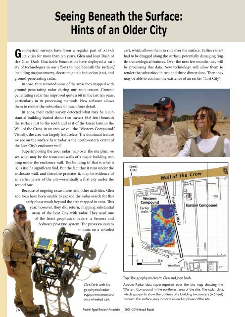
In 2001, their radar survey detected what may be a substantial<br />
building buried about two meters (6.6 feet) beneath<br />
the surface just to the south and east <strong>of</strong> the Great Gate in the<br />
Wall <strong>of</strong> the Crow, in an area we call the “Western Compound.”<br />
Visually, the area was largely featureless. The dominant feature<br />
we see on the surface here today is the northwestern extent <strong>of</strong><br />
the Lost City’s enclosure wall.<br />
Superimposing the 2001 radar map over the site plan, we<br />
see what may be the truncated walls <strong>of</strong> a major building running<br />
under the enclosure wall. The building (if that is what it<br />
is) is itself a significant find. But the fact that it runs under the<br />
enclosure wall, and therefore predates it, may be evidence <strong>of</strong><br />
an earlier phase <strong>of</strong> the city—essentially a first city under the<br />
second one.<br />
Because <strong>of</strong> ongoing excavations and other activities, Glen<br />
and Joan have been unable to expand the radar search for this<br />
early phase much beyond the area mapped in 2001. This<br />
year, however, they did return, mapping substantial<br />
areas <strong>of</strong> the Lost City with radar. They used one<br />
<strong>of</strong> the latest geophysical radars, a Sensors and<br />
S<strong>of</strong>tware proEKKO system. The proEKKO system<br />
mounts on a wheeled<br />
26<br />
Seeing Beneath the Surface:<br />
Hints <strong>of</strong> an Older City<br />
Glen Dash with his<br />
geophysical radar<br />
equipment mounted<br />
on a wheeled cart.<br />
<strong>Ancient</strong> <strong>Egypt</strong> Research Associates 2009–<strong>2010</strong> <strong>Annual</strong> <strong>Report</strong><br />
cart, which allows them to ride over the surface. Earlier radars<br />
had to be dragged along the surface, potentially damaging fragile<br />
archaeological features. Over the next few months they will<br />
be processing this data. New technology will allow them to<br />
render the subsurface in two and three dimensions. Then they<br />
may be able to confirm the existence <strong>of</strong> an earlier “Lost City.”<br />
Great<br />
Gate<br />
Earlier<br />
walls<br />
Top: The geophysical team: Glen and Joan Dash.<br />
Above: Radar data superimposed over the site map showing the<br />
Western Compound in the northwest area <strong>of</strong> the site. The radar data,<br />
which appear to show the outlines <strong>of</strong> a building two meters (6.6 feet)<br />
beneath the surface, may indicate an earlier phase <strong>of</strong> the site.