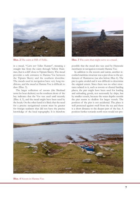
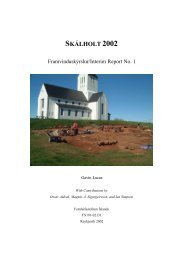
Illus. 1 Hamna Voe looking south-west to the farm (centre middle distance) and towards the mouth of voe.Tiptans Skerry is just visible in the middle of the voe near the mouth.It has already been noted that the rock off PointLodge near the entrance of the voe is known asHerrit’s Baa (Peters<strong>on</strong> 1993, 40).ArchaeologyMaritime background: Hamna VoeBlaeu’s map of Shetland dated to 1654 gives theplace-names, “Hana Vo” [Hamna Voe], “Midgairth”,“Goird” and “Housa”. The same names are repeatedby Johannes van Keulen in his map published in Amsterdamin 1730. The map by Herman Moll of 1745simply repeats the first and third of these names.The anchorages at <strong>Papa</strong> <strong>Stour</strong> were not marked <strong>on</strong>nautical maps before the later 18th century. ThomasPrest<strong>on</strong>’s New Hydrographic Survey of the Island ofShetland published in 1781 shows Hamna Voe as the<strong>on</strong>ly anchorage and noted “8 feetwater going in”. It recordedthat “Olis Voe”, Ollie’s Voe or West Voe wasfor small vessels. The map of the Depot General de laMarine of 1803, evidently based <strong>on</strong> Prest<strong>on</strong>’s survey,also marks Hamna Voe by an anchor, indicating asafe anchorage.Another map from 1807, the Admiralty Chart ofShetland similarly marks Hamna Voe as an anchorage.The North Sea Pilot from 1827 gives the following descripti<strong>on</strong>of <strong>Papa</strong> <strong>Stour</strong>: off the former lies <strong>Papa</strong> <strong>Stour</strong>, alarge rocky island, steep-to in every part; several small Voesof 7 and 8 feet water are <strong>on</strong> its eastern side, and <strong>on</strong>e calledHamna Voe <strong>on</strong> its western side; there is anchorage within thelatter in 8 feet water. The North Sea Pilot from 1847 addsthat In Housa Voe, <strong>Papa</strong> <strong>Stour</strong>, ships of moderate burdenmay find occasi<strong>on</strong>al anchorage, or wait for the tide to the southward.According to a later North Sea Pilot the entranceto Hamna Voe was difficult and the anchorage wasmainly used by small sloops and boats.The place-name Hamna Voe derives from theOld Norse “Höfn” denoting a harbour and “Vágr”denoting a bay. An interesting aspect of bays named“Hamna Voe” in Shetland, is that they seem to havesimilar topographical features. The North Sea Pilot(1847, 33) states that the place-name is often foundin basin-formed bays with a narrow entrance. HamnaVoe <strong>on</strong> <strong>Papa</strong> <strong>Stour</strong> has these characteristics. Theinlet is obstructed by Tiptans Skerry, a shallow bankthat divides the inlet into two possible entrances.There are several cairns surrounding the bay.On the highest point of the Hill of Feilie facingthe ocean towards west and south, there is a burialmound with a newer cairn in the middle (Illus. 2).In the eastern end of the bay there are two burialmounds with newer cairns in the middle and severalother st<strong>on</strong>e structures nearby. The protected baysurrounded by burial mounds intended to be seenfrom the waterways, indicates that the anchoragewas frequented in prehistoric periods. The c<strong>on</strong>necti<strong>on</strong>between burial mounds and the sea routes isexemplified in the following quote from Beowulf:The Geats built a mound then, in ten days, high and broad<strong>on</strong> the hill, a beac<strong>on</strong> for the warrior widely seen by sailors.Many meads are recorded in Shetland. A mead isa term derived from Old Norse, “mið”, that is a navigati<strong>on</strong>aldevice made by a straight sightline throughtwo fixed points. The meads were used to find anexact positi<strong>on</strong> <strong>on</strong> fishing grounds or a safe line intoanchorages or through fairways free from sunkenrocks or skerries (Melchers 2005).It is interesting that the cairns surrounding HamnaVoe seem to have been used in a similar navigati<strong>on</strong>alsystem. The cairn at the top of Hill of Feiliemight have been used as a landmark, signifying thelocati<strong>on</strong> of the harbour from a certain distance atsea. One of the cairns <strong>on</strong> the eastern ridge was used6
Illus. 2 The cairn at Hill of Feilie.in a mead, “Cairn over Yellow Hammer”, meaning astraight line from the cairn through Yellow Hammer,that is a cliff close to Tiptans Skerry. The meadprovides a safe entrance to Hamna Voe betweenthe Tiptans Skerry and the southern shoreline.The meads used in navigati<strong>on</strong> have very l<strong>on</strong>g traditi<strong>on</strong>s,and the mead at Hamna Voe is difficult todate (Illus. 3).The larger collecti<strong>on</strong> of noosts (the Shetlandterm for boat shelters) <strong>on</strong> the southern shore of thebay indicates that the Voe was used until recently(Illus. 4, 5), and the mead might have been used bythe locals. On the other hand it is likely that the needfor a precise navigati<strong>on</strong>al system must be greaterfor foreign seafarers that did not have the preciseknowledge of the local topography. It is thereforeIllus. 3 The cairn that might serve as a mead.possible that the mead also was used by Hanseaticmerchants in navigati<strong>on</strong> towards Hamna Voe.In additi<strong>on</strong> to the noosts and cairns, another recordedmaritime structure was a pier close to the settlementof Hamnavoe (see also below; Illus. 6). Thepier is quite eroded and it was difficult to determinethe original extent. Since there was no other structuresrelated to it, such as noosts or cleared landingplaces, the pier might have been used for loadingand unloading goods, not necessarily by ships, butby smaller vessels, because the water depths outsidethe pier seems to shallow for larger vessels. Thepositi<strong>on</strong> of the pier is not accidental. The place iswell protected against swell from the sea and thereis a short distance to the deeper part of the bay. Apositi<strong>on</strong> further towards north-west would not pro-Illus. 4 Noosts in Hamna Voe.7