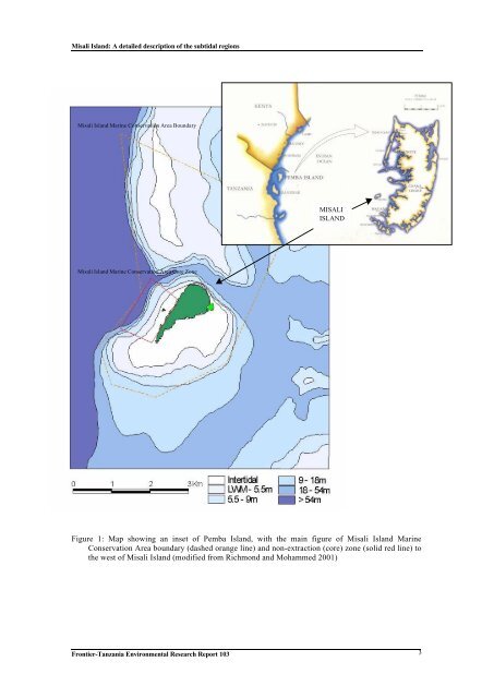
<strong>Misali</strong> <strong>Island</strong>: A detailed description of the subtidal regions1.2 ZANZIBAR ARCHIPELAGO & MISALI ISLANDPemba <strong>Island</strong> is the northern landmass which, along with Unguja, contributes to theZanzibar archipelago (see Figure 1). Pemba is world renowned for its spectacularmarine resources and in addition to Unguja, a number of sites of regional andinternational importance for marine biodiversity have been identified (UNEP 1989).However, this archipelago is increasingly threatened through resource use (Horrill et.al. 1994) and there is a paucity of biophysical information for this region. Therefore,further research is necessary on which to base future management initiatives for thePemba region.The importance of the present research area, <strong>Misali</strong> <strong>Island</strong>, was highlighted bypreliminary site visits, which revealed that surrounding marine areas suffered badlyfrom the 1998 global coral bleaching event (Mohammed et.al. 2000, Richmond &Mohammed 2001, pers. obs. 2002). The degraded reef areas could also be due topreviously-practiced destructive fishing techniques such as the use of dynamite (Arnold1997). Moreover, it has been considered likely that <strong>Misali</strong> <strong>Island</strong> is influenced by, andcan influence, other regional reefs and coastal habitats - in terms of larval supply,resource use and anthropogenic impacts (Horrill 1992).<strong>Misali</strong> <strong>Island</strong> is socio-economically important in terms of local resources such asfishing and tourism. It also supports ecologically important ecosystems such as coralreefs, extensive seagrass beds and mangrove stands. These habitats and resources, andthose on mainland Pemba that interact with them, all need to be examined andsubsequently considered in the ultimate recommendations for development of thecurrent management plan.1.3 CURRENT MANAGEMENT STATUS OF MISALI ISLANDAt present, management for <strong>Misali</strong> <strong>Island</strong> is limited, although in comparison to the restof Pemba, it has an improved system in that it is within the only conservation area. The<strong>Misali</strong> <strong>Island</strong> Marine Conservation Area (MIMCA) was legally established by theformer Ministry of Agriculture, Livestock and Natural Resources, Zanzibar, through 1)Fisheries Act, No.8 of 1988 and 2) Forest Resources Management and ConservationAct, No.10 of 1996. The main implementations are a core zone or non-extraction zone(1.4km 2 ) within a designated conservation area (21.6km 2 in total), which wereestablished May 1998 (see Figure for relative positions of the conservation area andnon-extraction zone). Recreational activities, passage and scientific research arepermitted within the non-extraction zone, but any type of activity that depletes thearea's natural resources is not. The <strong>Misali</strong> <strong>Island</strong> Conservation Association (MICA)manages these areas, which includes co-ordination of a team of Rangers (between threeand five each day) who reside on the island on a rotation basis.<strong>Frontier</strong>-<strong>Tanzania</strong> <strong>Environmental</strong> <strong>Research</strong> Report <strong>103</strong> 2
<strong>Misali</strong> <strong>Island</strong>: A detailed description of the subtidal regions<strong>Misali</strong> <strong>Island</strong> Marine Conservation Area BoundaryMISALIISLAND<strong>Misali</strong> <strong>Island</strong> Marine Conservation Area Core ZoneFigure 1: Map showing an inset of Pemba <strong>Island</strong>, with the main figure of <strong>Misali</strong> <strong>Island</strong> MarineConservation Area boundary (dashed orange line) and non-extraction (core) zone (solid red line) tothe west of <strong>Misali</strong> <strong>Island</strong> (modified from Richmond and Mohammed 2001)<strong>Frontier</strong>-<strong>Tanzania</strong> <strong>Environmental</strong> <strong>Research</strong> Report <strong>103</strong> 3