Frontier-Tanzania Environmental Research REPORT 103 Misali Island
Frontier-Tanzania Environmental Research REPORT 103 Misali Island
Frontier-Tanzania Environmental Research REPORT 103 Misali Island

Create successful ePaper yourself
Turn your PDF publications into a flip-book with our unique Google optimized e-Paper software.
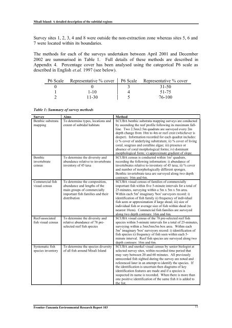
<strong>Misali</strong> <strong>Island</strong>: A detailed description of the subtidal regionsSurvey sites 1, 2, 3, 4 and 8 were outside the non-extraction zone whereas sites 5, 6 and7 were located within its boundaries.The methods for each of the surveys undertaken between April 2001 and December2002 are summarised in Table 1. Full details of these methods are described inAppendix 4. Percentage cover has been analysed using the categorical P6 scale asdescribed in English et.al. 1997 (see below).P6 Scale Representative % cover P6 Scale Representative % cover0 0 3 31-501 1-10 4 51-752 11-30 5 76-100Table 1: Summary of survey methodsSurvey Aims MethodBenthic substratamappingTo determine types, locations andextent of subtidal habitatsSCUBA benthic substrata mapping surveys are conductedby ascending the reef profile following its maximum fallline.Two 2.5mx2.5m quadrats are surveyed every 2mdepth change from 18m to 4m or reef crest (whichever isdeeper). Information recorded for each quadrat includes:i) % cover of underlying substratum; ii) % cover of livingcoral, seagrass and coralline algae; iii) presence orabsence of coral morphological forms; iv) dominantmorphological form; v) approximate gradient of slope.BenthicinvertebratecensusCommercial fishvisual censusReef-associatedfish visual censusSystematic fishspecies inventoryTo determine the diversity andabundance relative to invertebrateinventory of 45 taxaTo determine the composition,abundance and lengths of themain groups of commerciallyimportant fish families and theirdistributionTo determine the diversity andrelative abundance of 78 preselectedreef fish speciesTo determine the species diversityof all fish around <strong>Misali</strong> <strong>Island</strong>SCUBA census is conducted within 1m 2 quadrats,recording the following information: i) abundance ofinvertebrates relative to inventory of 45 taxa; ii) % coverand number of morphologically different sponges.Benthic invertebrate taxa are surveyed along two depthcontours: 16m and 6m.SCUBA visual census of families of commerciallyimportant fish within five 5-minute intervals for a total of25-minutes, surveying within a 5m x 5m x 5m area.Within each 5m 3 imaginary 'box' surveyors record: i)identification of fish family ii) frequency of individualfish seen or approximation if large shoal; iii) size ofindividual fish or average size of fish within shoal (tonearest 10cm). Commercial fish families are surveyedalong two depth contours: 16m and 6m.SCUBA visual census of the 78 pre-selected reef fishspecies within 5-minute intervals for a total of 25-minutes,surveying within a 5mx5mx5m box area. Within each5m 3 imaginary 'box' surveyors record: i) identification offish species ii) frequency of fish seen within each 5-minute interval. Reef fish species are surveyed along twodepth contours: 16m and 6m.SCUBA and snorkel visual census by senior biologist atselected survey sites, within recorded time period thatmay vary between 20 and 60 minutes. All previouslyunrecorded fish sighted during the survey are noted andreferenced later in an attempt to identify the species. Ifthe identification is uncertain then diagrams of keyidentification features are made and if a species issuspected its name is recorded. When there is more thanone positive identification of the same fish it is added tothe list.<strong>Frontier</strong>-<strong>Tanzania</strong> <strong>Environmental</strong> <strong>Research</strong> Report <strong>103</strong> 11