<strong>Katonga</strong> <strong>Wildlife</strong> <strong>Reserve</strong> 11.0 INTRODUCTIONUganda has an extremely rich and diverse biota (NEIC, 1994), which represents theintersection of no less than six biogeographic zones: the Guineo-Congolian, Sudanian, andSomalia-Masai regional centres of endemism, the Afromontane archipelago-like centre ofendemism, the Guinea-Congolia-Sudania regional transition zone, and the Lake Victoriaregional mosaic (White, 1983). Its moist tropical climate allows for high levels of primaryproductivity which promotes overall alpha diversity by allowing for greater nichedifferentiation, and its varied topography allows for high beta diversity (Whittaker, 1972).This diversity directly supports the 90% of the population (NEAP, 1993) who depend onnatural resources for their day to day livelihoods.During the political turmoil of the 1970s and 80s there was next to no <strong>co</strong>ntrol on theharvesting of plants and animals, and many of the nation’s protected areas were encroachedupon, eroding the rich natural resource base. In 1996 the Uganda <strong>Wildlife</strong> Authority (UWA)was formed from the former Game Department and Uganda National Parks. It is responsiblefor the <strong>co</strong>nservation of the nation’s wild animals and plants, and the management of <strong>Wildlife</strong>Protected Areas, including the production of management plans. The aims of the <strong>Frontier</strong>-Uganda <strong>Wildlife</strong> Protected Areas Project Baseline Surveys Programme are to assess thebiological and socio-e<strong>co</strong>nomic status of the nation’s <strong>Wildlife</strong> Protected Areas to assist UWAwith the development of management strategies: the specific aims of this survey are outlinedin section 1.1 below.1.1 AimsThe survey of the <strong>Katonga</strong> <strong>Wildlife</strong> <strong>Reserve</strong> aims to:• <strong>co</strong>llect baseline biological information about the vegetation, large mammals, and smallfauna of the reserve;• <strong>co</strong>llect baseline socio-e<strong>co</strong>nomic information about the <strong>co</strong>mmunities living in and aroundthe reserve, including information on their attitudes towards and their impacts on thereserve;• evaluate the opportunities for and threats to <strong>co</strong>nservation in and around the reserve;• <strong>co</strong>ntribute to existing knowledge at a national and international level; and• train self funding volunteer research assistants in biological and socio-e<strong>co</strong>nomic surveytechniques.1.2 Site descriptionThe reserve <strong>co</strong>vers an area of 207km 2 , and is located in western Uganda between 30°34’ and30°55’E, and 0°12’ and 0°18N (Fig. 1) in Kabarole District, although it is <strong>co</strong>ntiguous withMbarara District to the south. It is <strong>co</strong>vered by the Lands and Surveys Department map sheets67/1, 67/2, 67/3, and 67/4 (Series Y732) at 1:50,000.<strong>Frontier</strong>-Uganda <strong>Wildlife</strong> Protected Areas Project September 1997Baseline Surveys Programme Report No. 9
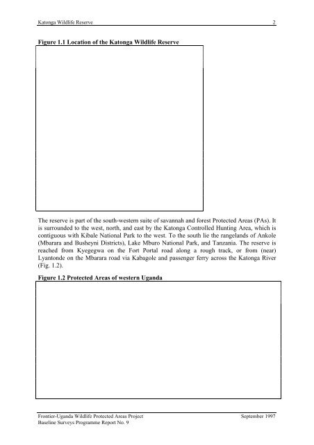
<strong>Katonga</strong> <strong>Wildlife</strong> <strong>Reserve</strong> 2Figure 1.1 Location of the <strong>Katonga</strong> <strong>Wildlife</strong> <strong>Reserve</strong>The reserve is part of the south-western suite of savannah and forest Protected Areas (PAs). Itis surrounded to the west, north, and east by the <strong>Katonga</strong> Controlled Hunting Area, which is<strong>co</strong>ntiguous with Kibale National Park to the west. To the south lie the rangelands of Ankole(Mbarara and Busheyni Districts), Lake Mburo National Park, and Tanzania. The reserve isreached from Kyegegwa on the Fort Portal road along a rough track, or from (near)Lyantonde on the Mbarara road via Kabagole and passenger ferry across the <strong>Katonga</strong> River(Fig. 1.2).Figure 1.2 Protected Areas of western Uganda<strong>Frontier</strong>-Uganda <strong>Wildlife</strong> Protected Areas Project September 1997Baseline Surveys Programme Report No. 9