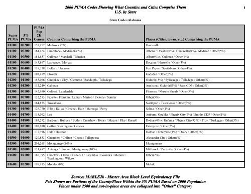
2000 PUMA Codes Showing What Counties and Cities
2000 PUMA Codes Showing What Counties and Cities
2000 PUMA Codes Showing What Counties and Cities

You also want an ePaper? Increase the reach of your titles
YUMPU automatically turns print PDFs into web optimized ePapers that Google loves.
Super<br />
<strong>PUMA</strong><br />
5%<br />
<strong>PUMA</strong><br />
<strong>2000</strong> <strong>PUMA</strong> <strong>Codes</strong> <strong>Showing</strong> <strong>What</strong> <strong>Counties</strong> <strong>and</strong> <strong>Cities</strong> Comprise Them 1<br />
U.S. by State<br />
State Code=Alabama<br />
<strong>PUMA</strong><br />
Pop<br />
2K<br />
Census <strong>Counties</strong> Comprising the <strong>PUMA</strong> Places (<strong>Cities</strong>, towns, etc.) Comprising the <strong>PUMA</strong><br />
01100 00200 157,952 Madison(57%) Huntsville<br />
01100 00300 184,424 Limestone / Madison(43%) Athens / Decatur(0%) / Huntsville(0%) / Madison / Other(5%)<br />
01100 00500 184,557 Cullman / Marshall / Winston Albertville / Cullman / Other(6%)<br />
01100 00600 145,867 Lawrence / Morgan Decatur / Hartselle / Other(3%)<br />
01200 00400 118,378 DeKalb / Jackson Fort Payne / Scottsboro / Other(4%)<br />
01200 01000 103,459 Etowah Gadsden / Other(3%)<br />
01200 01100 155,066 Cherokee / Clay / Cleburne / R<strong>and</strong>olph / Talladega Oxford(15%) / Sylacauga / Talladega / Other(5%)<br />
01200 01200 112,249 Calhoun Anniston / Oxford(85%) / Saks CDP / Other(3%)<br />
01300 00100 142,950 Colbert / Lauderdale Florence / Muscle Shoals / Other(4%)<br />
01300 00700 132,583 Fayette / Franklin / Lamar / Marion / Pickens / Sumter Other(5%)<br />
01300 01400 164,875 Tuscaloosa Northport / Tuscaloosa / Other(3%)<br />
01300 01500 128,750 Bibb / Dallas / Greene / Hale / Marengo / Perry Selma / Other(4%)<br />
01400 01700 115,092 Lee Auburn / Opelika / Phenix City(7%) / Smiths CDP / Other(1%)<br />
01400 01800 195,592 Barbour / Bullock / Butler / Crenshaw / Henry / Macon / Pike / Russell Dothan(0%) / Eufaula / Phenix City(93%) / Troy / Tuskegee / Other(5%)<br />
01400 02500 107,010 Coffee / Covington / Geneva Enterprise / Other(3%)<br />
01400 02600 137,916 Dale / Houston Dothan / Enterprise(1%) / Ozark / Other(3%)<br />
01500 01600 129,853 Chambers / Chilton / Coosa / Tallapoosa Alex<strong>and</strong>er City / Other(5%)<br />
01500 01900 201,568 Montgomery(90%) Montgomery<br />
01500 0<strong>2000</strong> 131,487 Autauga / Elmore / Montgomery(10%) Millbrook / Prattville / Other(4%)<br />
01600 02100 165,395 Choctaw / Clarke / Conecuh / Escambia / Lowndes / Monroe /<br />
Washington / Wilcox<br />
Other(7%)<br />
01600 02200 198,915 Mobile(50%) Mobile<br />
Source: MABLE2k - Master Area Block Level Equivalency File<br />
Pcts Shown are Portions of the County/Place Within the 5% <strong>PUMA</strong> Based on <strong>2000</strong> Population<br />
Places under 2500 <strong>and</strong> not-in-place areas are collapsed into "Other" Category
Super<br />
<strong>PUMA</strong><br />
5%<br />
<strong>PUMA</strong><br />
<strong>2000</strong> <strong>PUMA</strong> <strong>Codes</strong> <strong>Showing</strong> <strong>What</strong> <strong>Counties</strong> <strong>and</strong> <strong>Cities</strong> Comprise Them 2<br />
U.S. by State<br />
State Code=Alabama<br />
<strong>PUMA</strong><br />
Pop<br />
2K<br />
Census <strong>Counties</strong> Comprising the <strong>PUMA</strong> Places (<strong>Cities</strong>, towns, etc.) Comprising the <strong>PUMA</strong><br />
01600 02300 200,928 Mobile(50%) Prichard / Saral<strong>and</strong> / Tillmans Corner CDP / Other(6%)<br />
01600 02400 140,415 Baldwin Daphne / Fairhope / Other(4%)<br />
01701 00800 186,479 Blount / St. Clair / Walker Jasper / Leeds(13%) / Trussville(0%) / Other(7%)<br />
01701 00905 103,892 Jefferson(16%) Bessemer(97%) / Birmingham(1%) / Fairfield(0%) / Helena(0%) / Hoover<br />
(9%) / Hueytown / Other(2%)<br />
01701 01300 143,293 Shelby Alabaster / Birmingham(0%) / Helena / Hoover(25%) / Leeds(1%) /<br />
Pelham / Vestavia Hills(0%) / Other(3%)<br />
01702 00901 103,629 Jefferson(16%) Birmingham(40%) / Mountain Brook(0%) / Other(0%)<br />
01702 00902 123,233 Jefferson(19%) Bessemer(3%) / Birmingham(42%) / Fairfield / Forestdale<br />
CDP(0%) / Homewood(1%) / Other(0%)<br />
01702 00903 154,204 Jefferson(23%) Bessemer(0%) / Birmingham(3%) / Homewood(99%) / Hoover(66%) /<br />
Leeds(86%) / Mountain Brook / Vestavia Hills / Other(1%)<br />
01702 00904 177,089 Jefferson(27%) Birmingham(14%) / Center Point CDP / Forestdale<br />
CDP / Gardendale / Leeds(0%) / Trussville / Other(3%)<br />
Super<br />
<strong>PUMA</strong><br />
5%<br />
<strong>PUMA</strong><br />
<strong>PUMA</strong><br />
Pop 2K<br />
Census <strong>Counties</strong> Comprising the <strong>PUMA</strong><br />
State Code=Alaska<br />
Source: MABLE2k - Master Area Block Level Equivalency File<br />
Pcts Shown are Portions of the County/Place Within the 5% <strong>PUMA</strong> Based on <strong>2000</strong> Population<br />
Places under 2500 <strong>and</strong> not-in-place areas are collapsed into "Other" Category<br />
Places<br />
(<strong>Cities</strong>, towns, etc.)<br />
Comprising the <strong>PUMA</strong><br />
02100 00101 118,678 Anchorage Borough(46%) Anchorage(46%)<br />
02100 00102 141,605 Anchorage Borough(54%) Anchorage(54%)<br />
02100 00200 109,013 Kenai Peninsula Borough / Matanuska-Susitna Borough Other(37%)
Super<br />
<strong>PUMA</strong><br />
5%<br />
<strong>PUMA</strong><br />
<strong>2000</strong> <strong>PUMA</strong> <strong>Codes</strong> <strong>Showing</strong> <strong>What</strong> <strong>Counties</strong> <strong>and</strong> <strong>Cities</strong> Comprise Them 3<br />
U.S. by State<br />
<strong>PUMA</strong><br />
Pop 2K<br />
Census <strong>Counties</strong> Comprising the <strong>PUMA</strong><br />
State Code=Alaska<br />
02100 00300 157,110 Denali Borough / Fairbanks North Star Borough / Haines Borough / Juneau Borough / Ketchikan Gateway<br />
Borough / Sitka Borough / Southeast Fairbanks Census Area / Valdez-Cordova Census Area<br />
02100 00400 100,526 Aleutians East Borough / Aleutians West Census Area / Bethel Census Area / Bristol Bay Borough / Dillingham<br />
Census Area / Kodiak Isl<strong>and</strong> Borough / Lake <strong>and</strong> Peninsula Borough / Nome Census Area / North Slope<br />
Borough / Northwest Arctic Borough / Prince of Wales-Outer Ketchikan Census A / Skagway-Hoonah-Angoon Census<br />
Area / Wade Hampton Census Area / Wrangell-Petersburg Census Area / Yakutat Borough / Yukon-Koyukuk Census<br />
Area<br />
Super<br />
<strong>PUMA</strong><br />
5%<br />
<strong>PUMA</strong><br />
State Code=Arizona<br />
<strong>PUMA</strong><br />
Pop 2K<br />
Census <strong>Counties</strong> Comprising the <strong>PUMA</strong> Places (<strong>Cities</strong>, towns, etc.) Comprising the <strong>PUMA</strong><br />
04100 00300 166,893 Apache / Navajo Other(17%)<br />
04100 00400 116,320 Coconino Flagstaff / Sedona(29%) / Other(6%)<br />
Source: MABLE2k - Master Area Block Level Equivalency File<br />
Pcts Shown are Portions of the County/Place Within the 5% <strong>PUMA</strong> Based on <strong>2000</strong> Population<br />
Places under 2500 <strong>and</strong> not-in-place areas are collapsed into "Other" Category<br />
Places<br />
(<strong>Cities</strong>, towns, etc.)<br />
Comprising the <strong>PUMA</strong><br />
College<br />
CDP / Fairbanks / Juneau<br />
city <strong>and</strong> / Other(29%)<br />
Other(34%)<br />
04100 00500 167,517 Yavapai Cottonwood-Verde Village CDP / Peoria(0%) / Prescott / Prescott Valley / Sedona(71%) / Other(10%)<br />
04100 00600 174,747 La Paz / Mohave Bullhead City / Kingman / Lake Havasu City / Mohave Valley CDP / New Kingman-Butler<br />
CDP / Other(5%)<br />
04100 00700 160,026 Yuma Fortuna Foothills CDP / San Luis / Yuma / Other(5%)<br />
04200 00800 231,062 Gila / Pinal Apache Junction / Casa Gr<strong>and</strong>e / Eloy / Florence / Payson / Other(14%)<br />
04200 00900 198,172 Cochise / Graham / Greenlee / Santa<br />
Cruz<br />
Douglas / Nogales / Sierra Vista / Sierra Vista Southeast CDP / Other(11%)<br />
04301 00101 102,745 Maricopa(3%) Peoria(4%) / Sun City CDP(97%) / Sun City West CDP / Surprise(60%) / Other(2%)<br />
04301 00102 109,336 Maricopa(4%) Glendale(0%) / Peoria(96%) / Phoenix(0%) / Sun City CDP(3%) / Other(0%)<br />
04301 00108 116,247 Maricopa(4%) Glendale(53%) / Peoria(0%) / Phoenix(0%) / Other(0%)<br />
04301 00109 120,787 Maricopa(4%) Glendale(45%) / Goodyear(0%) / Peoria(0%) / Phoenix(0%) / Other(2%)
Super<br />
<strong>PUMA</strong><br />
5%<br />
<strong>PUMA</strong><br />
<strong>2000</strong> <strong>PUMA</strong> <strong>Codes</strong> <strong>Showing</strong> <strong>What</strong> <strong>Counties</strong> <strong>and</strong> <strong>Cities</strong> Comprise Them 4<br />
U.S. by State<br />
State Code=Arizona<br />
<strong>PUMA</strong><br />
Pop 2K<br />
Census <strong>Counties</strong> Comprising the <strong>PUMA</strong> Places (<strong>Cities</strong>, towns, etc.) Comprising the <strong>PUMA</strong><br />
04301 00110 103,499 Maricopa(3%) Avondale / Goodyear / Phoenix(0%) / Surprise(40%) / Other(4%)<br />
04302 00103 174,453 Maricopa(6%) Glendale(2%) / New River CDP(64%) / Peoria(0%) / Phoenix(12%) / Other(0%)<br />
04302 00104 188,935 Maricopa(6%) Phoenix(14%) / Scottsdale(2%) / Other(1%)<br />
04302 00107 146,150 Maricopa(5%) Paradise Valley(1%) / Phoenix(11%) / Scottsdale(0%) / Other(0%)<br />
04303 00105 152,743 Maricopa(5%) Fountain Hills / New River CDP(36%) / Paradise Valley(99%) / Phoenix(0%) / Scottsdale(54%) / Other(1%)<br />
04303 00106 100,324 Maricopa(3%) Mesa(0%) / Paradise Valley(1%) / Phoenix(0%) / Scottsdale(44%) / Tempe(0%) / Other(1%)<br />
04303 00114 183,523 Maricopa(6%) Apache Junction(1%) / Mesa(40%) / Other(3%)<br />
04303 00115 152,860 Maricopa(5%) Mesa(39%) / Tempe(0%) / Other(0%)<br />
04304 00112 170,752 Maricopa(6%) Phoenix(13%) / Other(0%)<br />
04304 00113 103,984 Maricopa(3%) Paradise Valley(0%) / Phoenix(8%) / Scottsdale(0%)<br />
04304 00117 143,876 Maricopa(5%) Phoenix(11%) / Tempe(0%)<br />
04305 00111 169,069 Maricopa(6%) Avondale(0%) / Glendale(0%) / Phoenix(12%) / Other(1%)<br />
04305 00118 148,303 Maricopa(5%) Phoenix(11%) / Other(0%)<br />
04305 00119 104,352 Maricopa(3%) Ch<strong>and</strong>ler(0%) / Phoenix(8%) / Tempe(0%) / Other(0%)<br />
04306 00116 163,902 Maricopa(5%) Ch<strong>and</strong>ler(0%) / Mesa(0%) / Phoenix(0%) / Scottsdale(0%) / Tempe / Other(1%)<br />
04306 00120 189,676 Maricopa(6%) Ch<strong>and</strong>ler(99%) / Gilbert(0%) / Phoenix(0%) / Sun Lakes CDP / Tempe(0%) / Other(0%)<br />
04306 00121 126,516 Maricopa(4%) Ch<strong>and</strong>ler(1%) / Gilbert / Mesa(0%) / Other(2%)<br />
04306 00122 100,117 Maricopa(3%) Gilbert(0%) / Mesa(22%) / Other(2%)<br />
04401 00202 107,604 Pima(13%) Tucson(22%) / Other(0%)<br />
04401 00203 101,880 Pima(12%) Casas Adobes CDP(27%) / Catalina Foothills CDP(96%) / Oro Valley(3%) / Tanque Verde<br />
CDP / Tucson(4%) / Other(0%)<br />
04401 00205 100,961 Pima(12%) Casas Adobes CDP(73%) / Catalina Foothills CDP(0%) / Marana(24%) / Oro<br />
Valley(97%) / Tucson(0%) / Other(3%)<br />
Source: MABLE2k - Master Area Block Level Equivalency File<br />
Pcts Shown are Portions of the County/Place Within the 5% <strong>PUMA</strong> Based on <strong>2000</strong> Population<br />
Places under 2500 <strong>and</strong> not-in-place areas are collapsed into "Other" Category
Super<br />
<strong>PUMA</strong><br />
5%<br />
<strong>PUMA</strong><br />
<strong>2000</strong> <strong>PUMA</strong> <strong>Codes</strong> <strong>Showing</strong> <strong>What</strong> <strong>Counties</strong> <strong>and</strong> <strong>Cities</strong> Comprise Them 5<br />
U.S. by State<br />
State Code=Arizona<br />
<strong>PUMA</strong><br />
Pop 2K<br />
Census <strong>Counties</strong> Comprising the <strong>PUMA</strong> Places (<strong>Cities</strong>, towns, etc.) Comprising the <strong>PUMA</strong><br />
04401 00206 107,307 Pima(13%) Catalina Foothills CDP(3%) / Green Valley CDP(3%) / Tucson(17%) / Other(2%)<br />
04402 00201 130,097 Pima(15%) Tucson(24%) / Other(2%)<br />
04402 00204 136,739 Pima(16%) Catalina Foothills CDP(1%) / Flowing Wells CDP / Tucson(25%) / Other(0%)<br />
04402 00207 159,158 Pima(19%) Drexel Heights CDP / Green Valley CDP(97%) / Marana(76%) / Tucson(8%) / Other(7%)<br />
Super<br />
<strong>PUMA</strong><br />
5%<br />
<strong>PUMA</strong><br />
State Code=Arkansas<br />
<strong>PUMA</strong><br />
Pop 2K<br />
Census <strong>Counties</strong> Comprising the <strong>PUMA</strong> Places (<strong>Cities</strong>, towns, etc.) Comprising the <strong>PUMA</strong><br />
05100 00100 153,406 Benton Bella Vista CDP / Bentonville / Rogers / Siloam<br />
Springs / Springdale(4%) / Other(4%)<br />
05100 00200 157,715 Washington Fayetteville / Springdale(96%) / Other(3%)<br />
05100 00300 144,943 Baxter / Boone / Carroll / Madison / Marion / Newton / Searcy Harrison / Mountain Home / Other(8%)<br />
05200 00400 127,980 Cleburne / Fulton / Independence / Izard / Sharp / Stone / Van<br />
Buren<br />
Other(8%)<br />
05200 00500 173,057 Clay / Craighead / Greene / Lawrence / R<strong>and</strong>olph Jonesboro / Paragould / Other(6%)<br />
05200 00600 102,845 Crittenden / Mississippi Blytheville / West Memphis / Other(4%)<br />
05200 00700 113,494 Cross / Lee / Phillips / Poinsett / St. Francis Forrest City / Other(6%)<br />
05200 00800 114,117 Jackson / Monroe / Prairie / White / Woodruff Searcy / Other(6%)<br />
05300 00900 183,133 Pulaski(51%) Little Rock<br />
05300 01000 178,341 Pulaski(49%) Jacksonville / Maumelle / North Little Rock / Sherwood / Other(3%)<br />
05300 01100 222,371 Faulkner / Lonoke / Saline Benton / Cabot / Conway / Other(9%)<br />
05400 01200 128,934 Conway / Johnson / Perry / Pope / Yell Russellville / Other(7%)<br />
Source: MABLE2k - Master Area Block Level Equivalency File<br />
Pcts Shown are Portions of the County/Place Within the 5% <strong>PUMA</strong> Based on <strong>2000</strong> Population<br />
Places under 2500 <strong>and</strong> not-in-place areas are collapsed into "Other" Category
Super<br />
<strong>PUMA</strong><br />
5%<br />
<strong>PUMA</strong><br />
<strong>2000</strong> <strong>PUMA</strong> <strong>Codes</strong> <strong>Showing</strong> <strong>What</strong> <strong>Counties</strong> <strong>and</strong> <strong>Cities</strong> Comprise Them 6<br />
U.S. by State<br />
State Code=Arkansas<br />
<strong>PUMA</strong><br />
Pop 2K<br />
Census <strong>Counties</strong> Comprising the <strong>PUMA</strong> Places (<strong>Cities</strong>, towns, etc.) Comprising the <strong>PUMA</strong><br />
05400 01300 168,318 Crawford / Sebastian Fort Smith / Van Buren / Other(4%)<br />
05400 01400 101,539 Franklin / Howard / Logan / Polk / Scott / Sevier Other(6%)<br />
05400 01500 151,212 Clark / Garl<strong>and</strong> / Hot Spring / Montgomery Arkadelphia / Hot Springs / Other(6%)<br />
05500 01600 121,491 Arkansas / Grant / Jefferson Pine Bluff / Other(4%)<br />
05500 01700 108,053 Ashley / Bradley / Chicot / Clevel<strong>and</strong> / Desha / Drew / Lincoln Other(7%)<br />
05500 01800 114,976 Calhoun / Columbia / Dallas / Ouachita / Union Camden / El Dorado / Magnolia / Other(4%)<br />
05500 01900 107,475 Hempstead / Lafayette / Little River / Miller / Nevada / Pike Hope / Texarkana / Other(4%)<br />
Source: MABLE2k - Master Area Block Level Equivalency File<br />
Pcts Shown are Portions of the County/Place Within the 5% <strong>PUMA</strong> Based on <strong>2000</strong> Population<br />
Places under 2500 <strong>and</strong> not-in-place areas are collapsed into "Other" Category
Super<br />
<strong>PUMA</strong><br />
5%<br />
<strong>PUMA</strong><br />
<strong>2000</strong> <strong>PUMA</strong> <strong>Codes</strong> <strong>Showing</strong> <strong>What</strong> <strong>Counties</strong> <strong>and</strong> <strong>Cities</strong> Comprise Them 7<br />
U.S. by State<br />
State Code=California<br />
<strong>PUMA</strong><br />
Pop 2K<br />
Census <strong>Counties</strong> Comprising the <strong>PUMA</strong> Places (<strong>Cities</strong>, towns, etc.) Comprising the <strong>PUMA</strong><br />
06010 00100 115,085 Del Norte / Lassen / Modoc / Siskiyou Susanville / Other(2%)<br />
06010 00200 126,518 Humboldt Arcata / Eureka / Fortuna / McKinleyville CDP / Other(1%)<br />
06010 00300 163,256 Shasta Redding / Other(2%)<br />
06020 00400 144,574 Lake / Mendocino Clearlake / Ukiah / Other(2%)<br />
06020 00500 114,318 Colusa / Glenn / Tehama / Trinity Red Bluff / Other(2%)<br />
06020 00600 203,171 Butte Chico / Magalia CDP / Oroville / Paradise / Other(2%)<br />
06030 00700 116,412 Nevada / Plumas / Sierra Grass Valley / Truckee / Other(2%)<br />
06030 00800 139,149 Sutter / Yuba Linda CDP / Marysville / Olivehurst CDP / South Yuba City CDP / Yuba<br />
City / Other(1%)<br />
06030 00900 168,660 Yolo Davis / West Sacramento / Woodl<strong>and</strong> / Other(1%)<br />
06040 01101 177,541 Sonoma(39%) Healdsburg / Santa Rosa(7%) / Windsor / Other(3%)<br />
06040 01102 115,251 Sonoma(25%) Petaluma / Rohnert Park / Other(0%)<br />
06040 01103 165,822 Sonoma(36%) Rohnert Park(0%) / Santa Rosa(93%) / Other(1%)<br />
06040 01201 100,916 Marin(41%) Novato / San Rafael(31%) / Other(1%)<br />
06040 01202 146,373 Marin(59%) Larkspur / Mill Valley / San Anselmo / San Rafael(69%) / Tamalpais-Homestead<br />
Valley CDP / Other(1%)<br />
06050 01000 124,279 Napa Napa / Other(1%)<br />
06050 01301 146,849 Solano(37%) Benicia / Vallejo / Other(0%)<br />
06050 01302 126,603 Solano(32%) Fairfield / Suisun City / Vacaville(0%) / Vallejo(0%) / Other(0%)<br />
06050 01303 121,090 Solano(31%) Dixon / Vacaville / Other(0%)<br />
06060 01401 127,590 Sacramento(10%) Sacramento(31%)<br />
06060 01402 108,826 Sacramento(9%) Sacramento(27%)<br />
06060 01403 170,602 Sacramento(14%) Sacramento(42%)<br />
Source: MABLE2k - Master Area Block Level Equivalency File<br />
Pcts Shown are Portions of the County/Place Within the 5% <strong>PUMA</strong> Based on <strong>2000</strong> Population<br />
Places under 2500 <strong>and</strong> not-in-place areas are collapsed into "Other" Category
Super<br />
<strong>PUMA</strong><br />
5%<br />
<strong>PUMA</strong><br />
<strong>2000</strong> <strong>PUMA</strong> <strong>Codes</strong> <strong>Showing</strong> <strong>What</strong> <strong>Counties</strong> <strong>and</strong> <strong>Cities</strong> Comprise Them 8<br />
U.S. by State<br />
State Code=California<br />
<strong>PUMA</strong><br />
Pop 2K<br />
Census <strong>Counties</strong> Comprising the <strong>PUMA</strong> Places (<strong>Cities</strong>, towns, etc.) Comprising the <strong>PUMA</strong><br />
06071 01501 133,925 Sacramento(11%) Citrus Heights(0%) / Foothill Farms CDP / North Highl<strong>and</strong>s CDP / Rio Linda<br />
CDP / Other(1%)<br />
06071 01502 106,738 Sacramento(9%) Citrus Heights / Other(0%)<br />
06071 01504 169,571 Sacramento(14%) Arden-Arcade CDP / Carmichael CDP(43%) / La Riviera CDP / North Highl<strong>and</strong>s<br />
CDP(0%) / Rancho Cordova CDP(57%) / Rosemont CDP(46%)<br />
06072 01503 142,880 Sacramento(12%) Carmichael CDP(57%) / Fair Oaks CDP / Folsom / Orangevale CDP / Rancho<br />
Cordova CDP(0%) / Other(0%)<br />
06072 01505 162,285 Sacramento(13%) Elk Grove CDP / Florin CDP / Laguna CDP(98%) / Parkway-South Sacramento<br />
CDP / Other(0%)<br />
06072 01506 101,082 Sacramento(8%) Galt / Laguna CDP(2%) / Rancho Cordova CDP(43%) / Rosemont<br />
CDP(54%) / Vineyard CDP / Other(1%)<br />
06080 01601 135,702 Placer(55%) Auburn / Granite Bay CDP / Lincoln / North Auburn<br />
CDP / Rocklin(14%) / Roseville(3%) / Other(2%)<br />
06080 01602 112,697 Placer(45%) Granite Bay CDP(0%) / Lincoln(0%) / Rocklin(86%) / Roseville(97%) / Other(0%)<br />
06080 01700 156,299 El Dorado Cameron Park CDP / El Dorado Hills CDP / South Lake Tahoe / Other(2%)<br />
06090 01800 179,291 Alpine / Amador / Calaveras / Inyo / Mariposa / Mono / Tuolumne Other(4%)<br />
06090 03100 210,554 Merced Atwater / Livingston / Los Banos / Merced / Other(2%)<br />
06090 03200 123,109 Madera Chowchilla / Madera / Other(1%)<br />
06100 01901 110,315 San Joaquin(20%) Stockton(45%)<br />
06100 01902 133,456 San Joaquin(24%) Stockton(55%)<br />
06100 02001 149,825 San Joaquin(27%) Lathrop / Manteca / Ripon / Tracy / Other(0%)<br />
06100 02002 170,002 San Joaquin(30%) Lodi / Other(2%)<br />
06110 02500 188,856 Stanislaus(42%) Modesto<br />
06110 02601 138,237 Stanislaus(31%) Ceres / Turlock / Other(1%)<br />
06110 02602 119,904 Stanislaus(27%) Oakdale / Patterson / Riverbank / Salida CDP / Other(1%)<br />
Source: MABLE2k - Master Area Block Level Equivalency File<br />
Pcts Shown are Portions of the County/Place Within the 5% <strong>PUMA</strong> Based on <strong>2000</strong> Population<br />
Places under 2500 <strong>and</strong> not-in-place areas are collapsed into "Other" Category
Super<br />
<strong>PUMA</strong><br />
5%<br />
<strong>PUMA</strong><br />
<strong>PUMA</strong><br />
Pop 2K<br />
Census<br />
<strong>2000</strong> <strong>PUMA</strong> <strong>Codes</strong> <strong>Showing</strong> <strong>What</strong> <strong>Counties</strong> <strong>and</strong> <strong>Cities</strong> Comprise Them 9<br />
U.S. by State<br />
State Code=California<br />
<strong>Counties</strong> Comprising the<br />
<strong>PUMA</strong> Places (<strong>Cities</strong>, towns, etc.) Comprising the <strong>PUMA</strong><br />
06121 02101 126,004 Contra Costa(13%) El Cerrito(8%) / El Sobrante CDP(1%) / Richmond(88%) / San Pablo / Other(0%)<br />
06121 02102 116,435 Contra Costa(12%) El Cerrito(92%) / El Sobrante<br />
CDP(99%) / Hercules / Martinez(0%) / Orinda(0%) / Pinole / Richmond(12%) / Other(1%)<br />
06121 02103 106,258 Contra Costa(11%) Bay Point CDP(13%) / Concord(19%) / Martinez(99%) / Pleasant Hill(95%) / Walnut Creek(0%) / Other(0%)<br />
06121 02104 149,173 Contra Costa(16%) Alamo CDP(21%) / Concord(4%) / Lafayette / Martinez(1%) / Moraga / Orinda / Pleasant Hill(5%) / Walnut<br />
Creek / Other(0%)<br />
06122 02105 111,307 Contra Costa(12%) Alamo CDP(79%) / Blackhawk-Camino Tassajara CDP / Danville / San Ramon / Other(0%)<br />
06122 02106 119,237 Contra Costa(13%) Antioch(11%) / Bay Point CDP(0%) / Clayton / Concord(77%) / Pittsburg(6%) / Walnut Creek(0%) / Other(0%)<br />
06122 02107 108,255 Contra Costa(11%) Antioch(39%) / Bay Point CDP(87%) / Concord(0%) / Pittsburg(94%) / Other(0%)<br />
06122 02108 112,147 Contra Costa(12%) Antioch(50%) / Brentwood / Oakley / Other(0%)<br />
06130 02201 136,975 San Francisco(18%) San Francisco(18%)<br />
06130 02202 107,285 San Francisco(14%) San Francisco(14%)<br />
06130 02203 107,054 San Francisco(14%) San Francisco(14%)<br />
06130 02204 109,355 San Francisco(14%) San Francisco(14%)<br />
06130 02205 105,532 San Francisco(14%) San Francisco(14%)<br />
06130 02206 105,194 San Francisco(14%) San Francisco(14%)<br />
06130 02207 105,338 San Francisco(14%) San Francisco(14%)<br />
06140 02301 140,752 San Mateo(20%) Daly City(93%) / Pacifica / San Bruno(0%) / Other(0%)<br />
06140 02302 112,191 San Mateo(16%) Daly City(7%) / Foster City(0%) / Millbrae(0%) / San Bruno / South San Francisco / Other(0%)<br />
06140 02303 100,602 San Mateo(14%) Burlingame / Hillsborough / Millbrae / San Bruno(0%) / San Mateo(43%) / Other(0%)<br />
06140 02304 114,773 San Mateo(16%) Foster City / Half Moon Bay / Millbrae(0%) / San Bruno(0%) / San Mateo(57%) / Other(0%)<br />
06140 02305 124,010 San Mateo(18%) Belmont / Foster City(0%) / North Fair Oaks CDP(0%) / Redwood City(90%) / San Carlos / Other(0%)<br />
06140 02306 114,833 San Mateo(16%) East Palo Alto / Menlo Park / North Fair Oaks CDP / Redwood City(10%) / Other(1%)<br />
Source: MABLE2k - Master Area Block Level Equivalency File<br />
Pcts Shown are Portions of the County/Place Within the 5% <strong>PUMA</strong> Based on <strong>2000</strong> Population<br />
Places under 2500 <strong>and</strong> not-in-place areas are collapsed into "Other" Category
Super<br />
<strong>PUMA</strong><br />
5%<br />
<strong>PUMA</strong><br />
<strong>PUMA</strong><br />
Pop 2K<br />
Census<br />
<strong>2000</strong> <strong>PUMA</strong> <strong>Codes</strong> <strong>Showing</strong> <strong>What</strong> <strong>Counties</strong> <strong>and</strong> <strong>Cities</strong> Comprise Them 10<br />
U.S. by State<br />
State Code=California<br />
<strong>Counties</strong> Comprising the<br />
<strong>PUMA</strong> Places (<strong>Cities</strong>, towns, etc.) Comprising the <strong>PUMA</strong><br />
06151 02401 119,187 Alameda(8%) Albany / Berkeley / Other(0%)<br />
06151 02402 157,015 Alameda(11%) Oakl<strong>and</strong>(38%) / Other(0%)<br />
06151 02403 125,518 Alameda(9%) Oakl<strong>and</strong>(29%) / Piedmont / Other(0%)<br />
06151 02404 131,451 Alameda(9%) Oakl<strong>and</strong>(33%)<br />
06152 02405 156,293 Alameda(11%) Alameda / Ashl<strong>and</strong> CDP(0%) / Castro Valley CDP(2%) / Oakl<strong>and</strong>(1%) / San Le<strong>and</strong>ro<br />
06152 02406 130,433 Alameda(9%) Ashl<strong>and</strong> CDP / Castro Valley CDP(98%) / Cherryl<strong>and</strong> CDP(90%) / Hayward(7%) / Oakl<strong>and</strong>(0%) / San<br />
Le<strong>and</strong>ro(0%) / San Lorenzo CDP / Other(0%)<br />
06152 02407 140,428 Alameda(10%) Cherryl<strong>and</strong> CDP(10%) / Hayward(93%) / Union City(2%) / Other(0%)<br />
06153 02408 130,230 Alameda(9%) Fremont(11%) / Hayward(0%) / Newark / Union City(98%) / Other(0%)<br />
06153 02409 181,534 Alameda(13%) Fremont(89%)<br />
06153 02410 171,652 Alameda(12%) Dublin / Hayward(0%) / Livermore / Pleasanton / Other(0%)<br />
06161 02701 184,797 Santa Clara(11%) Cupertino(1%) / Los Altos(98%) / Mountain View / Palo Alto / Saratoga(0%) / Stanford<br />
CDP / Sunnyvale(0%) / Other(0%)<br />
06161 02702 135,615 Santa Clara(8%) Cupertino(0%) / Mountain View(0%) / Santa Clara(5%) / Sunnyvale(99%) / Other(0%)<br />
06161 02703 108,439 Santa Clara(6%) Milpitas(0%) / San Jose(1%) / Santa Clara(93%) / Sunnyvale(0%) / Other(0%)<br />
06162 02704 123,403 Santa Clara(7%) Milpitas / San Jose(7%) / Other(0%)<br />
06162 02705 104,767 Santa Clara(6%) Alum Rock CDP / San Jose(9%) / Other(0%)<br />
06162 02713 105,055 Santa Clara(6%) San Jose(12%) / Other(0%)<br />
06162 02714 100,470 Santa Clara(6%) San Jose(11%) / Other(0%)<br />
06163 02706 102,115 Santa Clara(6%) Gilroy / Morgan Hill / San Jose(1%) / Other(0%)<br />
06163 02707 126,866 Santa Clara(8%) Campbell(1%) / Cupertino(98%) / Los Altos(2%) / Los Gatos(85%) / San Jose(0%) / Santa<br />
Clara(2%) / Saratoga(99%) / Sunnyvale(1%) / Other(0%)<br />
06163 02708 126,838 Santa Clara(8%) Campbell(75%) / Los Gatos(6%) / San Jose(11%) / Santa Clara(0%) / Saratoga(1%) / Other(0%)<br />
Source: MABLE2k - Master Area Block Level Equivalency File<br />
Pcts Shown are Portions of the County/Place Within the 5% <strong>PUMA</strong> Based on <strong>2000</strong> Population<br />
Places under 2500 <strong>and</strong> not-in-place areas are collapsed into "Other" Category
Super<br />
<strong>PUMA</strong><br />
5%<br />
<strong>PUMA</strong><br />
<strong>PUMA</strong><br />
Pop 2K<br />
Census<br />
<strong>2000</strong> <strong>PUMA</strong> <strong>Codes</strong> <strong>Showing</strong> <strong>What</strong> <strong>Counties</strong> <strong>and</strong> <strong>Cities</strong> Comprise Them 11<br />
U.S. by State<br />
State Code=California<br />
<strong>Counties</strong> Comprising the<br />
<strong>PUMA</strong> Places (<strong>Cities</strong>, towns, etc.) Comprising the <strong>PUMA</strong><br />
06163 02709 116,043 Santa Clara(7%) Campbell(2%) / San Jose(12%) / Santa Clara(0%) / Other(0%)<br />
06163 02710 143,990 Santa Clara(9%) Campbell(17%) / San Jose(15%) / Other(0%)<br />
06163 02711 100,883 Santa Clara(6%) Campbell(5%) / Los Gatos(9%) / San Jose(10%) / Other(0%)<br />
06163 02712 103,304 Santa Clara(6%) San Jose(11%) / Other(0%)<br />
06170 02801 122,562 Santa Cruz(48%) Capitola / Live Oak CDP / Santa Cruz(97%) / Other(1%)<br />
06170 02802 133,040 Santa Cruz(52%) Santa Cruz(3%) / Scotts Valley / Watsonville / Other(2%)<br />
06170 02900 151,060 Monterey(38%) Salinas<br />
06170 03001 130,206 Monterey(32%) Marina / Monterey / Pacific Grove / Prunedale CDP(6%) / Seaside / Other(1%)<br />
06170 03002 173,730 Monterey(30%) / San Benito Greenfield / Hollister / King City / Marina(0%) / Prunedale CDP(94%) / Soledad / Other(2%)<br />
06180 03301 296,056 Fresno(37%) Fresno(69%)<br />
06180 03302 131,596 Fresno(16%) Fresno(31%)<br />
06180 03401 139,883 Fresno(17%) Coalinga / Selma / Other(2%)<br />
06180 03402 231,872 Fresno(29%) Clovis / Parlier / Reedley / Sanger / Other(2%)<br />
06190 03501 105,125 Tulare(29%) Visalia / Other(0%)<br />
06190 03502 119,014 Tulare(32%) Porterville(99%) / Tulare / Other(1%)<br />
06190 03503 143,882 Tulare(39%) Dinuba / Lindsay / Porterville(1%) / Visalia(0%) / Other(2%)<br />
06190 03600 129,461 Kings Avenal / Corcoran / Hanford / Lemoore / Other(1%)<br />
06201 04000 158,007 San Bernardino(9%) Ontario<br />
06201 04100 127,743 San Bernardino(7%) Rancho Cucamonga<br />
06201 04200 128,929 San Bernardino(8%) Fontana<br />
06201 04401 145,990 San Bernardino(9%) Chino / Chino Hills / Montclair(4%) / Other(0%)<br />
06201 04402 108,047 San Bernardino(6%) Montclair(96%) / Upl<strong>and</strong> / Other(0%)<br />
Source: MABLE2k - Master Area Block Level Equivalency File<br />
Pcts Shown are Portions of the County/Place Within the 5% <strong>PUMA</strong> Based on <strong>2000</strong> Population<br />
Places under 2500 <strong>and</strong> not-in-place areas are collapsed into "Other" Category
Super<br />
<strong>PUMA</strong><br />
5%<br />
<strong>PUMA</strong><br />
<strong>PUMA</strong><br />
Pop 2K<br />
Census<br />
<strong>2000</strong> <strong>PUMA</strong> <strong>Codes</strong> <strong>Showing</strong> <strong>What</strong> <strong>Counties</strong> <strong>and</strong> <strong>Cities</strong> Comprise Them 12<br />
U.S. by State<br />
State Code=California<br />
<strong>Counties</strong> Comprising the<br />
<strong>PUMA</strong> Places (<strong>Cities</strong>, towns, etc.) Comprising the <strong>PUMA</strong><br />
06202 04300 185,401 San Bernardino(11%) San Bernardino<br />
06202 04403 204,331 San Bernardino(12%) Bloomington CDP / Colton(98%) / Gr<strong>and</strong> Terrace / Rialto(92%) / Other(1%)<br />
06202 04404 188,687 San Bernardino(11%) Colton(2%) / Highl<strong>and</strong> / Loma Linda / Redl<strong>and</strong>s / Yucaipa / Other(0%)<br />
06203 04405 166,142 San Bernardino(10%) Adelanto(0%) / Apple Valley(6%) / Barstow / Twentynine Palms / Victorville(1%) / Yucca Valley / Other(2%)<br />
06203 04406 185,721 San Bernardino(11%) Apple Valley(47%) / Crestline CDP / Hesperia / Rialto(8%) / Victorville(12%) / Other(2%)<br />
06203 04407 110,436 San Bernardino(6%) Adelanto / Apple Valley(46%) / Victorville(87%) / Other(0%)<br />
06210 03800 247,057 Kern(37%) Bakersfield<br />
06210 03901 125,980 Kern(19%) Delano / Shafter / Wasco / Other(1%)<br />
06210 03902 146,717 Kern(22%) Arvin / Lamont CDP / Ridgecrest / Rosamond CDP / Tehachapi / Other(2%)<br />
06210 03903 141,891 Kern(21%) Oildale CDP / Other(2%)<br />
06220 03701 117,927 San Luis Obispo(48%) Atascadero / Baywood-Los Osos CDP / El Paso de Robles (Paso Robles) / Morro Bay / Other(1%)<br />
06220 03702 128,754 San Luis Obispo(52%) Arroyo Gr<strong>and</strong>e / Grover Beach / Nipomo CDP / San Luis Obispo / Other(1%)<br />
06220 06701 198,345 Santa Barbara(50%) Lompoc / Orcutt CDP / Santa Maria / Other(1%)<br />
06220 06702 201,002 Santa Barbara(50%) Carpinteria / Goleta CDP / Isla Vista CDP / Montecito CDP / Santa Barbara / Other(0%)<br />
06230 06200 170,358 Ventura(23%) Oxnard<br />
06230 06300 100,916 Ventura(13%) San Buenaventura (Ventura)<br />
06230 06400 111,351 Ventura(15%) Simi Valley<br />
06230 06500 117,005 Ventura(16%) Thous<strong>and</strong> Oaks<br />
06230 06601 126,049 Ventura(17%) Fillmore / Port Hueneme / Santa Paula / Other(1%)<br />
06230 06602 127,518 Ventura(17%) Camarillo / Moorpark / Other(1%)<br />
06301 05401 162,235 Los Angeles(2%) Los Angeles(4%)<br />
06301 05402 126,845 Los Angeles(1%) Los Angeles(3%)<br />
Source: MABLE2k - Master Area Block Level Equivalency File<br />
Pcts Shown are Portions of the County/Place Within the 5% <strong>PUMA</strong> Based on <strong>2000</strong> Population<br />
Places under 2500 <strong>and</strong> not-in-place areas are collapsed into "Other" Category
Super<br />
<strong>PUMA</strong><br />
5%<br />
<strong>PUMA</strong><br />
<strong>PUMA</strong><br />
Pop 2K<br />
Census<br />
<strong>2000</strong> <strong>PUMA</strong> <strong>Codes</strong> <strong>Showing</strong> <strong>What</strong> <strong>Counties</strong> <strong>and</strong> <strong>Cities</strong> Comprise Them 13<br />
U.S. by State<br />
State Code=California<br />
<strong>Counties</strong><br />
Comprising the<br />
<strong>PUMA</strong> Places (<strong>Cities</strong>, towns, etc.) Comprising the <strong>PUMA</strong><br />
06301 05403 120,285 Los Angeles(1%) Los Angeles(3%)<br />
06301 05405 128,277 Los Angeles(1%) Los Angeles(3%)<br />
06302 05404 131,131 Los Angeles(1%) Los Angeles(4%)<br />
06302 05406 133,680 Los Angeles(1%) Los Angeles(4%)<br />
06302 05407 159,064 Los Angeles(2%) Los Angeles(4%)<br />
06303 05408 160,836 Los Angeles(2%) Los Angeles(4%)<br />
06303 05409 150,282 Los Angeles(2%) Los Angeles(4%)<br />
06303 05410 156,616 Los Angeles(2%) Los Angeles(4%)<br />
06304 05411 194,388 Los Angeles(2%) Beverly Hills(0%) / Los Angeles(5%) / Other(0%)<br />
06304 05412 164,698 Los Angeles(2%) Los Angeles(4%)<br />
06304 05413 233,983 Los Angeles(2%) Los Angeles(6%) / Other(0%)<br />
06305 05415 193,704 Los Angeles(2%) Los Angeles(5%)<br />
06305 05416 228,910 Los Angeles(2%) Los Angeles(6%) / Other(0%)<br />
06305 05417 153,663 Los Angeles(2%) Los Angeles(4%)<br />
06306 05414 123,129 Los Angeles(1%) Los Angeles(3%)<br />
06306 05418 107,542 Los Angeles(1%) Los Angeles(3%)<br />
06306 05419 156,039 Los Angeles(2%) Los Angeles(4%)<br />
06306 05420 114,788 Los Angeles(1%) Los Angeles(3%)<br />
06307 05421 161,383 Los Angeles(2%) Los Angeles(4%)<br />
06307 05422 119,937 Los Angeles(1%) Los Angeles(3%)<br />
06307 05423 129,796 Los Angeles(1%) Los Angeles(4%)<br />
06307 05424 184,246 Los Angeles(2%) Los Angeles(5%)<br />
Source: MABLE2k - Master Area Block Level Equivalency File<br />
Pcts Shown are Portions of the County/Place Within the 5% <strong>PUMA</strong> Based on <strong>2000</strong> Population<br />
Places under 2500 <strong>and</strong> not-in-place areas are collapsed into "Other" Category
Super<br />
<strong>PUMA</strong><br />
5%<br />
<strong>PUMA</strong><br />
<strong>PUMA</strong><br />
Pop 2K<br />
Census<br />
<strong>2000</strong> <strong>PUMA</strong> <strong>Codes</strong> <strong>Showing</strong> <strong>What</strong> <strong>Counties</strong> <strong>and</strong> <strong>Cities</strong> Comprise Them 14<br />
U.S. by State<br />
State Code=California<br />
<strong>Counties</strong><br />
Comprising the<br />
<strong>PUMA</strong> Places (<strong>Cities</strong>, towns, etc.) Comprising the <strong>PUMA</strong><br />
06401 04500 118,718 Los Angeles(1%) Lancaster<br />
06401 04600 116,670 Los Angeles(1%) Palmdale<br />
06401 04700 151,088 Los Angeles(2%) Santa Clarita<br />
06401 06101 122,141 Los Angeles(1%) Duarte(0%) / Glendora(0%) / Lake Los Angeles CDP / La Verne(1%) / Monrovia(0%) / San Dimas(0%) / Other(2%)<br />
06402 05200 149,473 Los Angeles(2%) Pomona<br />
06402 06105 159,524 Los Angeles(2%) Azusa / Baldwin Park(99%) / Citrus CDP(97%) / Duarte / Glendora(2%) / Monrovia(0%) / Vincent CDP(20%) / Other(0%)<br />
06402 06106 163,104 Los Angeles(2%) Citrus CDP(3%) / Claremont / Covina(7%) / Glendora(98%) / La Verne / Los Angeles(0%) / San Dimas(96%) / Other(0%)<br />
06403 05100 115,965 Los Angeles(1%) El Monte<br />
06403 05800 105,080 Los Angeles(1%) West Covina<br />
06403 06107 114,547 Los Angeles(1%) Citrus CDP(0%) / Covina(93%) / San Dimas(4%) / South San Jose Hills CDP / Vincent CDP(80%) / Walnut / Other(0%)<br />
06403 06108 110,972 Los Angeles(1%) Diamond Bar / Hacienda Heights CDP(0%) / Rowl<strong>and</strong> Heights CDP / South San Jose Hills CDP(1%) / Other(0%)<br />
06403 06109 126,720 Los Angeles(1%) Avocado Heights CDP / Baldwin Park(1%) / Hacienda Heights CDP(0%) / La Puente / Pico<br />
Rivera(0%) / Rosemead(0%) / South El Monte / Valinda CDP / West Puente Valley CDP / Whittier(0%) / Other(0%)<br />
06404 06102 142,241 Los Angeles(1%) Altadena CDP / Arcadia(1%) / Duarte(0%) / La Canada Flintridge / La Crescenta-Montrose CDP / Monrovia / Sierra<br />
Madre / Other(0%)<br />
06404 06103 110,116 Los Angeles(1%) Alhambra / Los Angeles(0%) / San Marino(0%) / South Pasadena<br />
06404 06104 172,377 Los Angeles(2%) Arcadia / East San Gabriel CDP / Rosemead(0%) / San Gabriel / San Marino / Temple City / Other(0%)<br />
06405 04800 100,316 Los Angeles(1%) Burbank / Los Angeles(0%)<br />
06405 04900 194,973 Los Angeles(2%) Glendale / Los Angeles(0%) / Other(0%)<br />
06405 05000 133,936 Los Angeles(1%) Los Angeles(0%) / Pasadena<br />
06406 05300 124,283 Los Angeles(1%) East Los Angeles CDP<br />
06406 06110 166,971 Los Angeles(2%) Hacienda Heights CDP / Pico Rivera(0%) / Santa Fe Springs(6%) / South Whittier CDP(0%) / West Whittier-Los Nietos<br />
CDP / Whittier(97%) / Other(0%)<br />
Source: MABLE2k - Master Area Block Level Equivalency File<br />
Pcts Shown are Portions of the County/Place Within the 5% <strong>PUMA</strong> Based on <strong>2000</strong> Population<br />
Places under 2500 <strong>and</strong> not-in-place areas are collapsed into "Other" Category
Super<br />
<strong>PUMA</strong><br />
5%<br />
<strong>PUMA</strong><br />
<strong>PUMA</strong><br />
Pop 2K<br />
Census<br />
<strong>2000</strong> <strong>PUMA</strong> <strong>Codes</strong> <strong>Showing</strong> <strong>What</strong> <strong>Counties</strong> <strong>and</strong> <strong>Cities</strong> Comprise Them 15<br />
U.S. by State<br />
State Code=California<br />
<strong>Counties</strong> Comprising<br />
the <strong>PUMA</strong> Places (<strong>Cities</strong>, towns, etc.) Comprising the <strong>PUMA</strong><br />
06406 06111 128,245 Los Angeles(1%) Commerce(0%) / Montebello / Pico Rivera / Rosemead(1%) / Other(0%)<br />
06406 06112 122,051 Los Angeles(1%) Montebello(0%) / Monterey Park / Rosemead / Other(0%)<br />
06407 05900 107,323 Los Angeles(1%) Downey<br />
06407 06000 103,298 Los Angeles(1%) Norwalk<br />
06407 06116 128,144 Los Angeles(1%) Bellflower / Paramount / Other(0%)<br />
06407 06117 130,374 Los Angeles(1%) Cerritos(0%) / La Mirada / Pico Rivera(0%) / Santa Fe Springs(94%) / South Whittier CDP / Whittier(3%) / Other(0%)<br />
06407 06118 163,666 Los Angeles(2%) Artesia / Cerritos / Hawaiian Gardens / Lakewood / Other(0%)<br />
06408 06113 145,553 Los Angeles(2%) Bell / Bell Gardens / Commerce / Cudahy / Maywood / Montebello(0%) / Other(0%)<br />
06408 06114 137,816 Los Angeles(1%) Commerce(0%) / Cudahy(0%) / Florence-Graham CDP / Huntington Park / Walnut Park CDP / Other(0%)<br />
06408 06115 168,966 Los Angeles(2%) Compton(1%) / Lynwood / Paramount(0%) / South Gate / Other(0%)<br />
06408 06119 149,972 Los Angeles(2%) Carson(1%) / Compton / Lynwood(0%) / Paramount(0%) / Willowbrook CDP / Other(0%)<br />
06409 05701 138,799 Los Angeles(1%) Long Beach(30%)<br />
06409 05702 196,892 Los Angeles(2%) Long Beach(43%)<br />
06409 05703 125,831 Los Angeles(1%) Long Beach(27%)<br />
06410 05600 137,946 Los Angeles(1%) Torrance<br />
06410 06120 110,297 Los Angeles(1%) Carson / Compton(0%) / West Carson CDP / Other(0%)<br />
06410 06121 100,797 Los Angeles(1%) Lomita / Palos Verdes Estates / Rancho Palos Verdes / Other(1%)<br />
06410 06122 131,712 Los Angeles(1%) El Segundo / Hermosa Beach / Manhattan Beach / Redondo Beach / Other(0%)<br />
06411 05500 112,580 Los Angeles(1%) Inglewood<br />
06411 06123 140,665 Los Angeles(1%) Gardena / Hawthorne(3%) / Lawndale / Westmont CDP / Other(0%)<br />
06411 06124 116,546 Los Angeles(1%) Hawthorne(97%) / Lennox CDP / Other(0%)<br />
06411 06125 218,389 Los Angeles(2%) Beverly Hills / Culver City / Santa Monica / View Park-Windsor Hills CDP / West Hollywood / Other(0%)<br />
Source: MABLE2k - Master Area Block Level Equivalency File<br />
Pcts Shown are Portions of the County/Place Within the 5% <strong>PUMA</strong> Based on <strong>2000</strong> Population<br />
Places under 2500 <strong>and</strong> not-in-place areas are collapsed into "Other" Category
Super<br />
<strong>PUMA</strong><br />
5%<br />
<strong>PUMA</strong><br />
<strong>PUMA</strong><br />
Pop 2K<br />
Census<br />
<strong>2000</strong> <strong>PUMA</strong> <strong>Codes</strong> <strong>Showing</strong> <strong>What</strong> <strong>Counties</strong> <strong>and</strong> <strong>Cities</strong> Comprise Them 16<br />
U.S. by State<br />
State Code=California<br />
<strong>Counties</strong> Comprising<br />
the <strong>PUMA</strong> Places (<strong>Cities</strong>, towns, etc.) Comprising the <strong>PUMA</strong><br />
06411 06126 108,804 Los Angeles(1%) Agoura Hills / Calabasas / Malibu / San Fern<strong>and</strong>o / Other(1%)<br />
06501 07000 126,003 Orange(4%) Brea(0%) / Fullerton<br />
06501 07604 205,563 Orange(7%) Brea / La Habra / Placentia / Yorba Linda / Other(0%)<br />
06501 07605 188,133 Orange(7%) Buena Park / Cypress / La Palma / Los Alamitos / Rossmoor CDP / Seal<br />
Beach / Stanton(1%) / Westminster(0%) / Other(0%)<br />
06502 06801 191,282 Orange(7%) Anaheim(58%) / Other(0%)<br />
06502 06802 137,014 Orange(5%) Anaheim(42%) / Placentia(0%) / Yorba Linda(0%) / Other(0%)<br />
06502 07400 128,919 Orange(5%) Orange / Other(0%)<br />
06503 07100 165,198 Orange(6%) Garden Grove / Westminster(0%) / Other(0%)<br />
06503 07300 143,072 Orange(5%) Irvine<br />
06503 07501 156,600 Orange(6%) Santa Ana(46%) / Other(0%)<br />
06503 07502 181,377 Orange(6%) Santa Ana(54%) / Tustin(0%)<br />
06504 06900 108,724 Orange(4%) Costa Mesa / Newport Beach(0%) / Other(0%)<br />
06504 07200 189,594 Orange(7%) Huntington Beach / Westminster(0%) / Other(0%)<br />
06504 07606 200,540 Orange(7%) Fountain Valley / Stanton(99%) / Westminster / Other(0%)<br />
06505 07601 172,917 Orange(6%) Aliso Viejo CDP(0%) / Dana Point(99%) / Laguna Beach(0%) / Laguna Hills(0%) / Laguna Niguel / Mission<br />
Viejo(0%) / San Clemente / San Juan Capistrano(76%) / Other(0%)<br />
06505 07602 168,193 Orange(6%) Coto de Caza CDP / Lake Forest(2%) / Mission Viejo(97%) / Rancho Santa Margarita / San Clemente(0%) / San Juan<br />
Capistrano(24%) / Other(0%)<br />
06505 07603 187,462 Orange(7%) Foothill Ranch CDP / Lake Forest(98%) / Mission Viejo(3%) / Tustin / Tustin Foothills CDP / Yorba<br />
Linda(0%) / Other(1%)<br />
06505 07607 195,698 Orange(7%) Aliso Viejo CDP / Dana Point(1%) / Laguna Beach / Laguna Hills / Laguna Niguel(0%) / Laguna Woods / Mission<br />
Viejo(0%) / Newport Beach / Other(0%)<br />
06601 07700 124,966 Riverside(8%) Corona<br />
Source: MABLE2k - Master Area Block Level Equivalency File<br />
Pcts Shown are Portions of the County/Place Within the 5% <strong>PUMA</strong> Based on <strong>2000</strong> Population<br />
Places under 2500 <strong>and</strong> not-in-place areas are collapsed into "Other" Category
Super<br />
<strong>PUMA</strong><br />
5%<br />
<strong>PUMA</strong><br />
<strong>PUMA</strong><br />
Pop 2K<br />
Census<br />
<strong>2000</strong> <strong>PUMA</strong> <strong>Codes</strong> <strong>Showing</strong> <strong>What</strong> <strong>Counties</strong> <strong>and</strong> <strong>Cities</strong> Comprise Them 17<br />
U.S. by State<br />
State Code=California<br />
<strong>Counties</strong> Comprising<br />
the <strong>PUMA</strong> Places (<strong>Cities</strong>, towns, etc.) Comprising the <strong>PUMA</strong><br />
06601 08001 288,783 Riverside(19%) Glen Avon CDP / Lake Elsinore / Mira Loma CDP / Norco / Pedley CDP / Perris(99%) / Rubidoux CDP / Wildomar<br />
CDP(18%) / Other(3%)<br />
06602 07801 111,647 Riverside(7%) Riverside(44%)<br />
06602 07802 143,519 Riverside(9%) Riverside(56%)<br />
06602 07900 142,381 Riverside(9%) Moreno Valley<br />
06602 08003 182,040 Riverside(12%) Banning / Beaumont / East Hemet CDP / Hemet / Perris(1%) / San Jacinto / Valle Vista CDP / Other(1%)<br />
06603 08002 196,134 Riverside(13%) Hemet(0%) / Lake Elsinore(0%) / Murrieta / Perris(0%) / Sun City CDP / Temecula / Wildomar CDP(82%) / Other(1%)<br />
06603 08004 196,172 Riverside(13%) Cathedral City / Desert Hot Springs / La Quinta(4%) / Palm Desert / Palm Springs / Rancho Mirage / Other(1%)<br />
06603 08005 159,745 Riverside(10%) Blythe / Coachella / Indio / La Quinta(96%) / Palm Desert(0%) / Other(1%)<br />
06603 08200 142,361 Imperial Brawley / Calexico / El Centro / Other(1%)<br />
06701 08101 241,025 San Diego(9%) Coronado / San Diego(18%) / Other(0%)<br />
06701 08107 168,125 San Diego(6%) Lemon Grove(0%) / San Diego(14%)<br />
06702 08102 124,020 San Diego(4%) Chula Vista(0%) / Coronado(0%) / Imperial Beach / San Diego(7%) / Other(0%)<br />
06702 08104 183,293 San Diego(7%) Bonita CDP(61%) / Chula Vista / La Presa CDP(2%) / National City(3%) / San Diego(0%) / Other(0%)<br />
06702 08105 210,139 San Diego(7%) Bonita CDP(39%) / Chula Vista(0%) / La Presa CDP(23%) / Lemon Grove(1%) / National City(97%) / San<br />
Diego(12%) / Other(0%)<br />
06703 08103 149,147 San Diego(5%) Alpine CDP / Bostonia CDP(11%) / Chula Vista(0%) / El Cajon(1%) / Lakeside CDP / Poway(0%) / Ramona CDP / Rancho<br />
San Diego CDP(0%) / San Diego(0%) / Santee(7%) / Winter Gardens CDP / Other(2%)<br />
06703 08106 107,380 San Diego(4%) Casa de Oro-Mount Helix CDP(64%) / La Mesa(1%) / La Presa CDP(76%) / Lemon Grove(99%) / Rancho San Diego<br />
CDP(75%) / San Diego(0%) / Spring Valley CDP<br />
06703 08108 227,240 San Diego(8%) Bostonia CDP(89%) / Casa de Oro-Mount Helix CDP(36%) / El Cajon(99%) / La Mesa / Lemon Grove(0%) / Rancho San<br />
Diego CDP(25%) / San Diego(0%) / Santee(93%) / Spring Valley CDP(0%) / Other(0%)<br />
06704 08109 230,212 San Diego(8%) San Diego(19%) / Santee(0%) / Other(0%)<br />
06704 08110 125,132 San Diego(4%) San Diego(10%) / Other(0%)<br />
Source: MABLE2k - Master Area Block Level Equivalency File<br />
Pcts Shown are Portions of the County/Place Within the 5% <strong>PUMA</strong> Based on <strong>2000</strong> Population<br />
Places under 2500 <strong>and</strong> not-in-place areas are collapsed into "Other" Category
Super<br />
<strong>PUMA</strong><br />
5%<br />
<strong>PUMA</strong><br />
<strong>PUMA</strong><br />
Pop 2K<br />
Census<br />
<strong>2000</strong> <strong>PUMA</strong> <strong>Codes</strong> <strong>Showing</strong> <strong>What</strong> <strong>Counties</strong> <strong>and</strong> <strong>Cities</strong> Comprise Them 18<br />
U.S. by State<br />
State Code=California<br />
<strong>Counties</strong> Comprising<br />
the <strong>PUMA</strong> Places (<strong>Cities</strong>, towns, etc.) Comprising the <strong>PUMA</strong><br />
06704 08111 139,299 San Diego(5%) San Diego(11%) / Other(0%)<br />
06704 08112 164,234 San Diego(6%) Poway / San Diego(9%) / Other(0%)<br />
06705 08113 176,440 San Diego(6%) Carlsbad / Encinitas / Oceanside(8%) / San Diego(0%) / San Marcos(0%) / Solana Beach / Vista(7%) / Other(0%)<br />
06705 08114 172,344 San Diego(6%) Escondido(94%) / San Diego(0%) / San Marcos(6%) / Other(1%)<br />
06705 08115 208,114 San Diego(7%) Carlsbad(0%) / Escondido(6%) / Fallbrook CDP / Oceanside(1%) / San Marcos(93%) / Vista(89%) / Other(1%)<br />
06705 08116 187,689 San Diego(7%) Carlsbad(0%) / Oceanside(90%) / Vista(4%) / Other(1%)<br />
Super<br />
<strong>PUMA</strong><br />
5%<br />
<strong>PUMA</strong><br />
State Code=Colorado<br />
<strong>PUMA</strong><br />
Pop<br />
2K<br />
Census <strong>Counties</strong> Comprising the <strong>PUMA</strong> Places (<strong>Cities</strong>, towns, etc.) Comprising the <strong>PUMA</strong><br />
08101 00101 100,089 Garfield / Jackson / Larimer(5%) / Mesa(3%) / Moffat / Rio Blanco / Routt Other(7%)<br />
08101 00102 120,093 Larimer(48%) Lovel<strong>and</strong> / Other(5%)<br />
08101 00200 118,652 Larimer(47%) Fort Collins<br />
08101 00300 180,936 Broomfield(0%) / Weld Brighton(1%) / Broomfield(0%) / Greeley / Longmont(0%) / Northglenn<br />
(0%) / Thornton(0%) / Other(8%)<br />
08102 00103 113,143 Mesa(97%) Clifton CDP / Gr<strong>and</strong> Junction / Other(4%)<br />
08102 00400 133,491 Bent / Cheyenne / Crowley / Elbert / Kiowa / Kit<br />
Carson / Lincoln / Logan / Morgan / Phillips / Prowers / Sedgwick /<br />
Washington / Yuma<br />
08102 00501 100,755 Alamosa / Baca / Conejos / Costilla / Huerfano / Las<br />
Animas / Otero / Pueblo(5%) / Rio Gr<strong>and</strong>e / Saguache<br />
08102 00600 147,931 Archuleta / Delta / Dolores / La Plata / Montezuma / Montrose / San<br />
Juan / San Miguel<br />
Fort Morgan / Sterling / Other(8%)<br />
Other(7%)<br />
Durango / Montrose / Other(9%)<br />
Source: MABLE2k - Master Area Block Level Equivalency File<br />
Pcts Shown are Portions of the County/Place Within the 5% <strong>PUMA</strong> Based on <strong>2000</strong> Population<br />
Places under 2500 <strong>and</strong> not-in-place areas are collapsed into "Other" Category
Super<br />
<strong>PUMA</strong><br />
5%<br />
<strong>PUMA</strong><br />
<strong>2000</strong> <strong>PUMA</strong> <strong>Codes</strong> <strong>Showing</strong> <strong>What</strong> <strong>Counties</strong> <strong>and</strong> <strong>Cities</strong> Comprise Them 19<br />
U.S. by State<br />
State Code=Colorado<br />
<strong>PUMA</strong><br />
Pop<br />
2K<br />
Census <strong>Counties</strong> Comprising the <strong>PUMA</strong> Places (<strong>Cities</strong>, towns, etc.) Comprising the <strong>PUMA</strong><br />
08103 00502 133,973 Pueblo(95%) Pueblo / Pueblo West CDP / Other(1%)<br />
08103 00700 119,652 Eagle / Gr<strong>and</strong> / Gunnison / Hinsdale / Lake / Mineral / Ouray / Pitkin /<br />
Summit<br />
Other(9%)<br />
08103 00901 102,268 El Paso(20%) Black Forest CDP / Colorado Springs(2%) / Fort Carson<br />
CDP / Fountain(57%) / Security-Widefield CDP(13%) / Other(4%)<br />
08103 01000 100,968 Chaffee / Custer / Fremont / Park / Teller Canon City / Other(6%)<br />
08104 00902 101,808 El Paso(20%) Colorado Springs(25%) / Other(1%)<br />
08104 00903 101,046 El Paso(20%) Colorado Springs(28%) / Other(0%)<br />
08104 00904 109,251 El Paso(21%) Cimarron Hills CDP / Colorado Springs(26%) / Other(0%)<br />
08104 00905 102,556 El Paso(20%) Cimarron Hills CDP(1%) / Colorado<br />
Springs(18%) / Fountain(43%) / Security-Widefield<br />
CDP(87%) / Other(0%)<br />
08201 00801 107,466 Boulder(6%) / Clear Creek / Gilpin / Jefferson(15%) Arvada(0%) / Boulder(0%) / Golden(95%) / Lakewood(0%) / Wheat<br />
Ridge(0%) / Other(7%)<br />
08201 00802 113,092 Boulder(42%) / Broomfield(0%) Boulder(0%) / Broomfield(0%) / Lafayette(98%) / Longmont / Louisville<br />
(1%) / Other(1%)<br />
08201 00803 107,227 Boulder(40%) Boulder(99%) / Lafayette(1%) / Other(1%)<br />
08201 00804 101,798 Adams(1%) / Boulder(12%) / Broomfield(90%) / Jefferson(6%) Arvada(6%) / Boulder(1%) / Broomfield(90%) / Lafayette(1%) /<br />
Louisville / Thornton(0%) / Westminster(23%) / Other(1%)<br />
08202 00812 117,406 Denver(21%) Denver(21%)<br />
08202 00813 100,089 Denver(18%) Denver(18%)<br />
08202 00814 100,910 Denver(18%) Denver(18%)<br />
08202 00815 142,364 Arapahoe(4%) / Denver(22%) Aurora(0%) / Denver(22%) / Other(2%)<br />
08202 00816 114,985 Denver(21%) Denver(21%)<br />
Source: MABLE2k - Master Area Block Level Equivalency File<br />
Pcts Shown are Portions of the County/Place Within the 5% <strong>PUMA</strong> Based on <strong>2000</strong> Population<br />
Places under 2500 <strong>and</strong> not-in-place areas are collapsed into "Other" Category
Super<br />
<strong>PUMA</strong><br />
5%<br />
<strong>PUMA</strong><br />
<strong>2000</strong> <strong>PUMA</strong> <strong>Codes</strong> <strong>Showing</strong> <strong>What</strong> <strong>Counties</strong> <strong>and</strong> <strong>Cities</strong> Comprise Them 20<br />
U.S. by State<br />
State Code=Colorado<br />
<strong>PUMA</strong><br />
Pop<br />
2K<br />
Census <strong>Counties</strong> Comprising the <strong>PUMA</strong> Places (<strong>Cities</strong>, towns, etc.) Comprising the <strong>PUMA</strong><br />
08203 00805 105,982 Adams(24%) / Broomfield(10%) / Jefferson(3%) Berkley<br />
CDP(12%) / Broomfield(10%) / Northglenn(87%) / Thornton(1%) /<br />
Westminster(66%) / Other(0%)<br />
08203 00806 110,684 Adams(32%) Brighton(0%) / Commerce City(0%) / Federal<br />
Heights / Northglenn(13%) / Sherrelwood<br />
CDP(18%) / Thornton(98%) / Welby<br />
CDP(30%) / Westminster(1%) / Other(0%)<br />
08203 00807 101,408 Adams(29%) Arvada(0%) / Berkley CDP(88%) / Brighton / Commerce<br />
City / Sherrelwood CDP(82%) / Thornton(1%) / Welby<br />
CDP(70%) / Westminster(6%) / Other(1%)<br />
08203 00817 109,722 Adams(1%) / Jefferson(20%) Arvada(94%) / Berkley CDP(0%) / Westminster(4%) / Wheat<br />
Ridge(7%) / Other(1%)<br />
08204 00808 112,814 Adams(4%) / Arapahoe(20%) Aurora(21%) / Other(4%)<br />
08204 00809 103,816 Adams(1%) / Arapahoe(20%) Aurora(38%)<br />
08204 00810 113,602 Adams(8%) / Arapahoe(18%) Aurora(41%)<br />
08204 00811 102,959 Arapahoe(21%) Aurora(0%) / Castlewood CDP / Englewood(2%) / Greenwood<br />
Village / Littleton(5%) / Southglenn CDP / Other(1%)<br />
08205 00818 100,888 Jefferson(19%) Arvada(0%) / Golden(0%) / Lakewood(40%) / Wheat<br />
Ridge(93%) / Other(1%)<br />
08205 00819 135,315 Jefferson(26%) Golden(5%) / Ken Caryl CDP(21%) / Lakewood(59%) / Other(3%)<br />
08205 00820 104,775 Arapahoe(16%) / Jefferson(5%) Columbine<br />
CDP / Englewood(98%) / Lakewood(1%) / Littleton(95%) / Other(1%)<br />
08205 00821 106,540 Douglas(43%) / Jefferson(6%) Columbine CDP(0%) / Highl<strong>and</strong>s Ranch CDP(86%) / Ken Caryl<br />
CDP(79%) / Littleton(0%) / Other(2%)<br />
08205 00822 100,807 Douglas(57%) Aurora(0%) / Castle Rock / Highl<strong>and</strong>s Ranch<br />
CDP(14%) / Parker / Other(3%)<br />
Source: MABLE2k - Master Area Block Level Equivalency File<br />
Pcts Shown are Portions of the County/Place Within the 5% <strong>PUMA</strong> Based on <strong>2000</strong> Population<br />
Places under 2500 <strong>and</strong> not-in-place areas are collapsed into "Other" Category
Super<br />
<strong>PUMA</strong><br />
5%<br />
<strong>PUMA</strong><br />
<strong>2000</strong> <strong>PUMA</strong> <strong>Codes</strong> <strong>Showing</strong> <strong>What</strong> <strong>Counties</strong> <strong>and</strong> <strong>Cities</strong> Comprise Them 21<br />
U.S. by State<br />
<strong>PUMA</strong> Pop<br />
2K Census<br />
State Code=Connecticut<br />
<strong>Counties</strong><br />
Comprising the<br />
<strong>PUMA</strong> Places (<strong>Cities</strong>, towns, etc.) Comprising the <strong>PUMA</strong><br />
09100 00100 182,193 Litchfield Torrington / Other(9%)<br />
09100 01400 123,539 New Haven(15%) Naugatuck / Other(6%)<br />
09100 01900 107,271 New Haven(13%) Waterbury<br />
09100 02100 183,303 Fairfield(21%) Danbury / Other(7%)<br />
09200 00200 150,378 Hartford(18%) Windsor Locks CDP / Other(8%)<br />
09200 00400 154,723 Hartford(18%) West Hartford CDP / Other(6%)<br />
09200 00500 107,980 Hartford(13%) Bristol / Other(3%)<br />
09300 00300 104,315 Hartford(12%) Central Manchester CDP / East Hartford CDP / Other(1%)<br />
09300 00600 107,081 Hartford(12%) New Britain / Other(2%)<br />
09300 00700 111,128 Hartford(13%) Newington CDP / Wethersfield CDP / Other(3%)<br />
09300 00800 121,578 Hartford(14%) Hartford<br />
09400 00900 136,364 Toll<strong>and</strong> Storrs CDP / Other(8%)<br />
09400 01000 109,091 Windham Willimantic CDP / Other(6%)<br />
09400 01100 128,912 New London(50%) Norwich / Other(6%)<br />
09400 01200 130,176 New London(50%) Conning Towers-Nautilus Park CDP / Groton / New London / Other(5%)<br />
09500 01300 155,071 Middlesex Middletown / Other(7%)<br />
09500 01500 124,305 New Haven(15%) Meriden / North Haven CDP / Wallingford Center CDP / Other(2%)<br />
09500 01600 117,335 New Haven(14%) Ansonia / Derby / North Haven CDP(0%) / Other(5%)<br />
09500 01700 117,898 New Haven(14%) Milford city / Orange CDP / West Haven / Other(0%)<br />
09500 01800 110,034 New Haven(13%) East Haven CDP / Other(5%)<br />
09500 0<strong>2000</strong> 123,626 New Haven(15%) New Haven<br />
09600 02200 206,179 Fairfield(23%) Shelton / Stratford CDP / Trumbull CDP / Other(5%)<br />
Source: MABLE2k - Master Area Block Level Equivalency File<br />
Pcts Shown are Portions of the County/Place Within the 5% <strong>PUMA</strong> Based on <strong>2000</strong> Population<br />
Places under 2500 <strong>and</strong> not-in-place areas are collapsed into "Other" Category
Super<br />
<strong>PUMA</strong><br />
Super<br />
<strong>PUMA</strong><br />
5%<br />
<strong>PUMA</strong><br />
<strong>2000</strong> <strong>PUMA</strong> <strong>Codes</strong> <strong>Showing</strong> <strong>What</strong> <strong>Counties</strong> <strong>and</strong> <strong>Cities</strong> Comprise Them 22<br />
U.S. by State<br />
<strong>PUMA</strong> Pop<br />
2K Census<br />
State Code=Connecticut<br />
<strong>Counties</strong><br />
Comprising the<br />
<strong>PUMA</strong> Places (<strong>Cities</strong>, towns, etc.) Comprising the <strong>PUMA</strong><br />
09600 02300 236,473 Fairfield(27%) Darien CDP / Norwalk / Westport CDP / Other(7%)<br />
09600 02400 139,529 Fairfield(16%) Bridgeport<br />
09600 02500 117,083 Fairfield(13%) Stamford<br />
5%<br />
<strong>PUMA</strong><br />
<strong>PUMA</strong> Pop<br />
2K Census<br />
State Code=Delaware<br />
<strong>Counties</strong><br />
Comprising<br />
the <strong>PUMA</strong> Places (<strong>Cities</strong>, towns, etc.) Comprising the <strong>PUMA</strong><br />
10100 00101 150,716 New Castle(30%) Wilmington / Other(14%)<br />
10100 00102 125,253 New Castle(25%) Hockessin CDP / Newark(55%) / Pike Creek CDP / Other(13%)<br />
10100 00103 122,063 New Castle(24%) Bear CDP(39%) / Brookside CDP / Newark(45%) / Wilmington(0%) / Other(15%)<br />
10100 00104 102,233 New Castle(20%) Bear CDP(61%) / Glasgow CDP / Newark(0%) / Other(14%)<br />
10100 00200 126,697 Kent Dover / Other(17%)<br />
10100 00300 156,638 Sussex Other(27%)<br />
Source: MABLE2k - Master Area Block Level Equivalency File<br />
Pcts Shown are Portions of the County/Place Within the 5% <strong>PUMA</strong> Based on <strong>2000</strong> Population<br />
Places under 2500 <strong>and</strong> not-in-place areas are collapsed into "Other" Category
<strong>2000</strong> <strong>PUMA</strong> <strong>Codes</strong> <strong>Showing</strong> <strong>What</strong> <strong>Counties</strong> <strong>and</strong> <strong>Cities</strong> Comprise Them 23<br />
U.S. by State<br />
Super<br />
<strong>PUMA</strong><br />
5%<br />
<strong>PUMA</strong><br />
State Code=District of Columbia<br />
<strong>PUMA</strong> Pop<br />
2K Census<br />
<strong>Counties</strong> Comprising the<br />
<strong>PUMA</strong><br />
Places<br />
(<strong>Cities</strong>, towns,<br />
etc.)<br />
Comprising the<br />
<strong>PUMA</strong><br />
11100 00101 101,578 District of Columbia(18%) Washington(18%)<br />
11100 00102 106,159 District of Columbia(19%) Washington(19%)<br />
11100 00103 117,201 District of Columbia(20%) Washington(20%)<br />
11100 00104 139,614 District of Columbia(24%) Washington(24%)<br />
11100 00105 107,507 District of Columbia(19%) Washington(19%)<br />
Source: MABLE2k - Master Area Block Level Equivalency File<br />
Pcts Shown are Portions of the County/Place Within the 5% <strong>PUMA</strong> Based on <strong>2000</strong> Population<br />
Places under 2500 <strong>and</strong> not-in-place areas are collapsed into "Other" Category
Super<br />
<strong>PUMA</strong><br />
5%<br />
<strong>PUMA</strong><br />
<strong>2000</strong> <strong>PUMA</strong> <strong>Codes</strong> <strong>Showing</strong> <strong>What</strong> <strong>Counties</strong> <strong>and</strong> <strong>Cities</strong> Comprise Them 24<br />
U.S. by State<br />
State Code=Florida<br />
<strong>PUMA</strong><br />
Pop 2K<br />
Census <strong>Counties</strong> Comprising the <strong>PUMA</strong> Places (<strong>Cities</strong>, towns, etc.) Comprising the <strong>PUMA</strong><br />
12010 00101 193,053 Escambia(66%) Bellview CDP(85%) / Brent CDP / Ferry Pass CDP(14%) / Myrtle Grove<br />
CDP / Pensacola(93%) / Warrington CDP / West Pensacola<br />
CDP / Other(1%)<br />
12010 00102 101,357 Escambia(34%) Bellview CDP(15%) / Ensley CDP / Ferry Pass CDP(86%) / Gonzalez<br />
CDP / Pensacola(7%) / Other(1%)<br />
12010 00200 117,743 Santa Rosa Other(2%)<br />
12020 00300 170,498 Okaloosa Crestview / Destin / Fort Walton Beach / Niceville / Wright<br />
CDP / Other(2%)<br />
12020 00400 126,893 Holmes / Jackson / Walton / Washington Other(2%)<br />
12020 00500 148,217 Bay Callaway / Lynn Haven / Panama City / Upper Gr<strong>and</strong> Lagoon<br />
CDP / Other(1%)<br />
12030 00600 118,181 Calhoun / Franklin / Gulf / Jefferson / Liberty / Madison / Taylor / Wakulla Other(2%)<br />
12030 00701 171,782 Leon(72%) Tallahassee(95%) / Other(0%)<br />
12030 00702 112,757 Gadsden / Leon(28%) Tallahassee(5%) / Other(2%)<br />
12040 00800 117,907 Dixie / Gilchrist / Hamilton / Lafayette / Levy / Suwannee Other(2%)<br />
12040 00900 118,302 Baker / Bradford / Columbia / Union Other(2%)<br />
12040 01001 107,751 Alachua(49%) Gainesville(98%) / Other(0%)<br />
12040 01002 110,204 Alachua(51%) Gainesville(2%) / Other(2%)<br />
12051 01101 106,695 Duval(6%) / Nassau Fern<strong>and</strong>ina Beach / Jacksonville(6%) / Other(1%)<br />
12051 01102 136,875 Duval(18%) Jacksonville(19%)<br />
12051 01103 105,872 Duval(14%) Jacksonville(14%)<br />
12051 01104 124,697 Duval(16%) Atlantic Beach / Jacksonville(11%) / Jacksonville Beach / Other(0%)<br />
12051 01105 104,611 Duval(13%) Jacksonville(14%)<br />
12052 01106 101,008 Duval(13%) Jacksonville(14%)<br />
Source: MABLE2k - Master Area Block Level Equivalency File<br />
Pcts Shown are Portions of the County/Place Within the 5% <strong>PUMA</strong> Based on <strong>2000</strong> Population<br />
Places under 2500 <strong>and</strong> not-in-place areas are collapsed into "Other" Category
Super<br />
<strong>PUMA</strong><br />
5%<br />
<strong>PUMA</strong><br />
<strong>PUMA</strong><br />
Pop 2K<br />
Census<br />
<strong>2000</strong> <strong>PUMA</strong> <strong>Codes</strong> <strong>Showing</strong> <strong>What</strong> <strong>Counties</strong> <strong>and</strong> <strong>Cities</strong> Comprise Them 25<br />
U.S. by State<br />
State Code=Florida<br />
<strong>Counties</strong> Comprising<br />
the <strong>PUMA</strong> Places (<strong>Cities</strong>, towns, etc.) Comprising the <strong>PUMA</strong><br />
12052 01107 156,784 Duval(20%) Jacksonville(21%)<br />
12052 01200 123,135 St. Johns Fruit Cove CDP / Palm Valley CDP / St. Augustine / Other(1%)<br />
12052 01300 140,814 Clay Bellair-Meadowbrook Terrace CDP / Lakeside CDP / Middleburg CDP / Other(1%)<br />
12060 01400 120,255 Flagler / Putnam Palatka / Palm Coast / Other(1%)<br />
12060 01901 192,698 Volusia(43%) Daytona Beach(0%) / De Bary / De L<strong>and</strong> / Deltona / Edgewater(0%) / New Smyrna Beach(0%) / Ormond<br />
Beach(10%) / Port Orange(10%) / Other(1%)<br />
12060 01902 120,738 Volusia(27%) Daytona Beach(85%) / Holly Hill / Ormond Beach(90%) / Other(0%)<br />
12060 01903 129,907 Volusia(29%) Daytona Beach(15%) / Edgewater / New Smyrna Beach / Port Orange(90%) / South Daytona / Other(0%)<br />
12070 01501 104,671 Marion(40%) Ocala / Other(1%)<br />
12070 01502 154,245 Marion(60%) Other(3%)<br />
12070 01600 171,430 Citrus / Sumter Homosassa Springs CDP / Other(3%)<br />
12081 01700 130,802 Hern<strong>and</strong>o Spring Hill CDP / Other(1%)<br />
12081 02501 117,591 Pasco(34%) L<strong>and</strong> O' Lakes CDP(91%) / Zephyrhills / Other(1%)<br />
12081 02502 119,444 Pasco(35%) Bayonet Point CDP / Hudson CDP / Jasmine Estates CDP(46%) / L<strong>and</strong> O' Lakes CDP(9%) / Other(1%)<br />
12081 02503 107,730 Pasco(31%) Elfers CDP / Holiday CDP / Jasmine Estates CDP(54%) / New Port Richey / Other(1%)<br />
12082 02601 119,663 Pinellas(13%) Dunedin(10%) / East Lake CDP / Oldsmar(32%) / Palm Harbor CDP / Tarpon Springs / Other(0%)<br />
12082 02602 103,249 Pinellas(11%) Clearwater(21%) / Dunedin(90%) / Oldsmar(68%) / Safety Harbor / Other(0%)<br />
12082 02603 113,201 Pinellas(12%) Clearwater(79%) / Dunedin(0%) / Largo(2%) / Other(0%)<br />
12082 02604 105,885 Pinellas(11%) Clearwater(0%) / Largo(92%) / Pinellas Park(0%) / St. Petersburg(1%) / Other(1%)<br />
12083 02605 117,145 Pinellas(13%) Largo(6%) / Pinellas Park(10%) / St. Petersburg(0%) / Seminole / Other(2%)<br />
12083 02606 109,279 Pinellas(12%) Largo(0%) / Pinellas Park(90%) / St. Petersburg(15%) / West <strong>and</strong> East Lealman CDP / Other(0%)<br />
12083 02607 125,883 Pinellas(14%) St. Petersburg(51%)<br />
12083 02608 127,177 Pinellas(14%) Gulfport / St. Petersburg(33%) / Other(1%)<br />
Source: MABLE2k - Master Area Block Level Equivalency File<br />
Pcts Shown are Portions of the County/Place Within the 5% <strong>PUMA</strong> Based on <strong>2000</strong> Population<br />
Places under 2500 <strong>and</strong> not-in-place areas are collapsed into "Other" Category
Super<br />
<strong>PUMA</strong><br />
5%<br />
<strong>PUMA</strong><br />
<strong>2000</strong> <strong>PUMA</strong> <strong>Codes</strong> <strong>Showing</strong> <strong>What</strong> <strong>Counties</strong> <strong>and</strong> <strong>Cities</strong> Comprise Them 26<br />
U.S. by State<br />
State Code=Florida<br />
<strong>PUMA</strong><br />
Pop 2K<br />
Census <strong>Counties</strong> Comprising the <strong>PUMA</strong> Places (<strong>Cities</strong>, towns, etc.) Comprising the <strong>PUMA</strong><br />
12084 02701 138,437 Hillsborough(14%) Tampa(43%) / Other(0%)<br />
12084 02702 149,564 Hillsborough(15%) Palm River-Clair Mel CDP(15%) / Tampa(48%) / Town 'n' Country CDP(3%) / Other(0%)<br />
12084 02703 116,729 Hillsborough(12%) Citrus Park CDP(89%) / Greater Northdale CDP(11%) / Keystone CDP / Tampa(0%) / Town 'n'<br />
Country CDP(97%) / Westchase CDP / Other(0%)<br />
12084 02704 147,502 Hillsborough(15%) Citrus Park CDP(11%) / Egypt Lake-Leto CDP / Greater Carrollwood CDP / Greater Northdale<br />
CDP(89%) / Lake Magdalene CDP / Lutz CDP / Tampa(1%) / Other(0%)<br />
12085 02705 105,500 Hillsborough(11%) Tampa(7%) / Temple Terrace / University CDP / Other(1%)<br />
12085 02706 101,490 Hillsborough(10%) Br<strong>and</strong>on CDP(2%) / Plant City / Other(1%)<br />
12085 02707 133,534 Hillsborough(13%) Br<strong>and</strong>on CDP(98%) / Palm River-Clair Mel CDP(85%) / Riverview CDP / Tampa(0%) / Other(0%)<br />
12085 02708 106,192 Hillsborough(11%) Bloomingdale CDP / Greater Sun Center CDP / Riverview CDP(0%) / Other(1%)<br />
12091 01801 105,439 Lake(50%) Citrus Ridge CDP(38%) / Lady Lake(0%) / Leesburg / Other(1%)<br />
12091 01802 105,089 Lake(50%) Eustis / Lady Lake / Leesburg(0%) / Other(1%)<br />
12091 02001 154,102 Seminole(42%) Altamonte Springs / Casselberry(0%) / Forest City CDP / Lake<br />
Mary(66%) / Longwood(55%) / Sanford(19%) / Wekiwa Springs CDP / Other(1%)<br />
12091 02002 104,758 Seminole(29%) Lake Mary(34%) / Longwood(32%) / Oviedo(85%) / Sanford(81%) / Winter Springs(0%) / Other(1%)<br />
12091 02003 106,336 Seminole(29%) Altamonte Springs(0%) / Casselberry / Goldenrod<br />
CDP(48%) / Longwood(12%) / Oviedo(15%) / Winter Springs / Other(1%)<br />
12092 02201 101,682 Orange(11%) Apopka / Lockhart CDP(15%) / Ocoee(0%) / Pine Hills CDP(42%) / Other(1%)<br />
12092 02204 136,998 Orange(15%) Orl<strong>and</strong>o(54%) / Pine Hills CDP(52%) / Other(0%)<br />
12092 02205 102,607 Orange(11%) Fairview Shores CDP / Lockhart CDP(85%) / Maitl<strong>and</strong> / Orl<strong>and</strong>o(8%) / Pine Hills CDP(6%) / Winter<br />
Park / Other(0%)<br />
12092 02206 141,404 Orange(16%) Azalea Park CDP / Goldenrod CDP(52%) / Orl<strong>and</strong>o(26%) / Union Park CDP(34%) / Other(1%)<br />
12092 02207 104,160 Orange(12%) Orl<strong>and</strong>o(0%) / Union Park CDP(66%) / Other(2%)<br />
12093 02202 179,736 Orange(20%) Citrus Ridge CDP(12%) / Ocoee / Orl<strong>and</strong>o(4%) / Winter Garden / Other(2%)<br />
Source: MABLE2k - Master Area Block Level Equivalency File<br />
Pcts Shown are Portions of the County/Place Within the 5% <strong>PUMA</strong> Based on <strong>2000</strong> Population<br />
Places under 2500 <strong>and</strong> not-in-place areas are collapsed into "Other" Category
Super<br />
<strong>PUMA</strong><br />
5%<br />
<strong>PUMA</strong><br />
<strong>2000</strong> <strong>PUMA</strong> <strong>Codes</strong> <strong>Showing</strong> <strong>What</strong> <strong>Counties</strong> <strong>and</strong> <strong>Cities</strong> Comprise Them 27<br />
U.S. by State<br />
State Code=Florida<br />
<strong>PUMA</strong><br />
Pop 2K<br />
Census <strong>Counties</strong> Comprising the <strong>PUMA</strong> Places (<strong>Cities</strong>, towns, etc.) Comprising the <strong>PUMA</strong><br />
12093 02203 129,757 Orange(14%) Conway CDP / Meadow Woods CDP / Oak Ridge CDP / Orl<strong>and</strong>o(7%) / Other(1%)<br />
12093 02300 172,493 Osceola Citrus Ridge CDP(17%) / Kissimmee / Poinciana CDP / St. Cloud / Yeehaw Junction<br />
CDP / Other(1%)<br />
12100 02101 155,942 Brevard(33%) Cocoa / Port St. John CDP / Rockledge / Titusville / Other(1%)<br />
12100 02102 118,603 Brevard(25%) Cocoa Beach / Melbourne(4%) / Merritt Isl<strong>and</strong> CDP / Titusville(0%) / Other(1%)<br />
12100 02103 100,779 Brevard(21%) Melbourne(87%) / Palm Bay(0%) / Other(1%)<br />
12100 02104 100,906 Brevard(21%) Melbourne(9%) / Palm Bay / Other(0%)<br />
12110 02401 150,697 Polk(31%) Lakel<strong>and</strong>(96%) / Lakel<strong>and</strong> Highl<strong>and</strong>s CDP(0%) / Other(1%)<br />
12110 02402 125,708 Polk(26%) Auburndale / Citrus Ridge CDP(33%) / Haines City(97%) / Lakel<strong>and</strong>(0%) / Winter<br />
Haven(98%) / Other(1%)<br />
12110 02403 102,295 Polk(21%) Bartow(98%) / Haines City(3%) / Lake Wales / Winter Haven(0%) / Other(1%)<br />
12110 02404 105,224 Polk(22%) Auburndale(0%) / Bartow(2%) / Lakel<strong>and</strong>(4%) / Lakel<strong>and</strong> Highl<strong>and</strong>s CDP / Winter<br />
Haven(2%) / Other(1%)<br />
12120 03200 148,857 Indian River / Okeechobee Florida Ridge CDP / Sebastian / Vero Beach / Vero Beach South CDP / Other(1%)<br />
12120 03300 192,695 St. Lucie Fort Pierce / Lakewood Park CDP / Port St. Lucie / Other(1%)<br />
12120 03400 126,731 Martin Hobe Sound CDP / Jensen Beach CDP / Palm City CDP / Port Salerno CDP / Stuart / Other(1%)<br />
12130 03100 193,299 DeSoto / Glades / Hardee / Hendry / Highl<strong>and</strong>s Other(3%)<br />
12130 03701 123,148 Collier(49%) Golden Gate CDP(0%) / Marco Isl<strong>and</strong>(0%) / Naples / Other(2%)<br />
12130 03702 128,229 Collier(51%) Golden Gate CDP / Immokalee CDP / Marco Isl<strong>and</strong> / Other(1%)<br />
12140 02801 134,394 Manatee(51%) Bradenton / South Bradenton CDP / Other(1%)<br />
12140 02802 129,608 Manatee(49%) Bayshore Gardens CDP / Palmetto / Other(2%)<br />
12140 02901 175,152 Sarasota(54%) Fruitville CDP / Gulf Gate Estates CDP(26%) / Sarasota / Sarasota Springs CDP / Other(2%)<br />
12140 02902 150,805 Sarasota(46%) Englewood CDP(66%) / Gulf Gate Estates CDP(74%) / North Port / South Venice<br />
CDP / Venice / Other(1%)<br />
Source: MABLE2k - Master Area Block Level Equivalency File<br />
Pcts Shown are Portions of the County/Place Within the 5% <strong>PUMA</strong> Based on <strong>2000</strong> Population<br />
Places under 2500 <strong>and</strong> not-in-place areas are collapsed into "Other" Category
Super<br />
<strong>PUMA</strong><br />
5%<br />
<strong>PUMA</strong><br />
<strong>PUMA</strong><br />
Pop 2K<br />
Census<br />
<strong>2000</strong> <strong>PUMA</strong> <strong>Codes</strong> <strong>Showing</strong> <strong>What</strong> <strong>Counties</strong> <strong>and</strong> <strong>Cities</strong> Comprise Them 28<br />
U.S. by State<br />
State Code=Florida<br />
<strong>Counties</strong> Comprising the<br />
<strong>PUMA</strong> Places (<strong>Cities</strong>, towns, etc.) Comprising the <strong>PUMA</strong><br />
12150 03000 141,627 Charlotte Englewood CDP(34%) / Port Charlotte CDP / Punta Gorda / Other(1%)<br />
12150 03800 102,286 Lee(23%) Cape Coral<br />
12150 03901 117,247 Lee(27%) Bonita Springs / Iona CDP / San Carlos Park CDP / Other(1%)<br />
12150 03902 105,694 Lee(24%) Fort Myers(0%) / Lehigh Acres CDP / North Fort Myers CDP / Other(1%)<br />
12150 03903 115,661 Lee(26%) Cypress Lake CDP / Fort Myers / North Fort Myers CDP(0%) / Villas CDP / Other(1%)<br />
12161 03501 183,935 Palm Beach(16%) Jupiter / North Palm Beach / Palm Beach Gardens / Riviera Beach / West Palm Beach(2%) / Other(1%)<br />
12161 03502 129,888 Palm Beach(11%) Lake Worth(0%) / Palm Beach(80%) / West Palm Beach(93%) / Other(1%)<br />
12161 03503 110,005 Palm Beach(10%) Greenacres / Lake Worth(1%) / Lake Worth Corridor CDP(14%) / Palm Springs(94%) / Other(1%)<br />
12161 03504 107,544 Palm Beach(10%) Boynton Beach(0%) / Greenacres(0%) / Lake Worth / Lake Worth Corridor CDP(86%) / Palm Beach(20%) / Palm<br />
Springs(6%) / Other(1%)<br />
12162 03505 129,324 Palm Beach(11%) Boynton Beach(95%) / Delray Beach(0%) / Other(1%)<br />
12162 03506 107,735 Palm Beach(10%) Boca Raton(0%) / Boynton Beach(5%) / Delray Beach / Kings Point CDP / Other(1%)<br />
12162 03507 105,032 Palm Beach(9%) Boca Del Mar CDP(48%) / Boca Raton / Other(0%)<br />
12162 03508 102,811 Palm Beach(9%) Boca Del Mar CDP(52%) / Boca Raton(0%) / Hamptons at Boca Raton CDP / S<strong>and</strong>alfoot Cove CDP / Other(1%)<br />
12162 03509 154,910 Palm Beach(14%) Belle Glade / Palm Beach Gardens(0%) / Royal Palm Beach / Wellington / West Palm Beach(4%) / Other(1%)<br />
12171 03601 132,951 Broward(8%) Coconut Creek(0%) / Coral Springs / Parkl<strong>and</strong> / Other(0%)<br />
12171 03602 105,683 Broward(7%) Coconut Creek / Coral Springs(0%) / Deerfield Beach(0%) / Margate / North Lauderdale(24%) / Other(0%)<br />
12171 03603 104,503 Broward(6%) Deerfield Beach / Lighthouse Point / Pompano Beach(4%) / Other(0%)<br />
12171 03604 109,935 Broward(7%) Fort Lauderdale(10%) / North Lauderdale(1%) / Oakl<strong>and</strong> Park(0%) / Pompano Beach(96%) / Other(0%)<br />
12172 03605 141,829 Broward(9%) Davie(0%) / Fort Lauderdale(89%) / Oakl<strong>and</strong> Park(0%) / Other(0%)<br />
12172 03606 174,040 Broward(11%) Fort Lauderdale(1%) / Lauderdale Lakes(98%) / Lauderhill(0%) / North Lauderdale(75%) / Oakl<strong>and</strong><br />
Park / Tamarac / Wilton Manors / Other(0%)<br />
12172 03607 106,010 Broward(7%) Fort Lauderdale(0%) / Lauderdale Lakes(2%) / Lauderhill / Plantation(0%) / Sunrise(31%) / Other(0%)<br />
Source: MABLE2k - Master Area Block Level Equivalency File<br />
Pcts Shown are Portions of the County/Place Within the 5% <strong>PUMA</strong> Based on <strong>2000</strong> Population<br />
Places under 2500 <strong>and</strong> not-in-place areas are collapsed into "Other" Category
Super<br />
<strong>PUMA</strong><br />
5%<br />
<strong>PUMA</strong><br />
<strong>PUMA</strong><br />
Pop 2K<br />
Census<br />
<strong>2000</strong> <strong>PUMA</strong> <strong>Codes</strong> <strong>Showing</strong> <strong>What</strong> <strong>Counties</strong> <strong>and</strong> <strong>Cities</strong> Comprise Them 29<br />
U.S. by State<br />
State Code=Florida<br />
<strong>Counties</strong> Comprising the<br />
<strong>PUMA</strong> Places (<strong>Cities</strong>, towns, etc.) Comprising the <strong>PUMA</strong><br />
12172 03608 144,356 Broward(9%) Davie(0%) / Lauderhill(0%) / Plantation / Sunrise(64%) / Other(0%)<br />
12173 03609 112,455 Broward(7%) Cooper City(0%) / Dania Beach / Davie(47%) / Fort<br />
Lauderdale(0%) / Hall<strong>and</strong>ale(0%) / Hollywood(34%) / Pembroke Pines(0%) / Other(0%)<br />
12173 03610 135,089 Broward(8%) Cooper City / Coral Springs(0%) / Davie(52%) / Parkl<strong>and</strong>(0%) / Pembroke<br />
Pines(0%) / Sunrise(6%) / Weston / Other(0%)<br />
12173 03611 130,089 Broward(8%) Davie(1%) / Pembroke Pines(94%) / Other(0%)<br />
12173 03612 102,383 Broward(6%) Hall<strong>and</strong>ale(7%) / Miramar / Pembroke Pines(6%) / Other(0%)<br />
12173 03613 123,695 Broward(8%) Hall<strong>and</strong>ale(93%) / Hollywood(66%) / Other(0%)<br />
12181 04001 102,123 Miami-Dade(5%) Aventura / Ives Estates CDP / Norl<strong>and</strong> CDP(29%) / North Miami(1%) / North Miami Beach(48%) / Ojus<br />
CDP / Sunny Isles Beach(79%) / Other(0%)<br />
12181 04002 104,643 Miami-Dade(5%) Carol City CDP / Norl<strong>and</strong> CDP(71%) / Scott Lake CDP / Other(0%)<br />
12181 04003 105,305 Miami-Dade(5%) Country Club CDP / Hialeah(2%) / Hialeah Gardens / Miami Lakes CDP / Other(0%)<br />
12181 04004 118,445 Miami-Dade(5%) Hialeah(52%) / Hialeah Gardens(0%) / Other(0%)<br />
12182 04005 137,551 Miami-Dade(6%) Brownsville CDP / Gladeview CDP / Hialeah(44%) / Miami(1%) / Other(0%)<br />
12182 04006 101,338 Miami-Dade(4%) Golden Glades CDP(24%) / Hialeah(2%) / Miami(0%) / North Miami(13%) / North Miami<br />
Beach(0%) / Opa-locka / Pinewood CDP / West Little River CDP(93%) / Other(0%)<br />
12182 04007 128,514 Miami-Dade(6%) Golden Glades CDP(76%) / Miami Shores(0%) / Norl<strong>and</strong> CDP(0%) / North Miami(86%) / North Miami<br />
Beach(52%) / Ojus CDP(0%) / Sunny Isles Beach(21%) / Other(0%)<br />
12182 04008 125,727 Miami-Dade(6%) Miami(0%) / Miami Beach / Miami Shores / North Miami(0%) / West Little River CDP(7%) / Other(0%)<br />
12183 04009 101,190 Miami-Dade(4%) Miami(28%) / Other(0%)<br />
12183 04010 110,054 Miami-Dade(5%) Key Biscayne / Miami(27%) / Miami Beach(0%) / Other(0%)<br />
12183 04011 158,650 Miami-Dade(7%) Coral Gables(3%) / Miami(43%) / Other(0%)<br />
12183 04012 138,722 Miami-Dade(6%) Doral CDP / Fountainbleau CDP / Miami(0%) / Miami Springs / Olympia Heights CDP(0%) / Sweetwater / Tamiami<br />
CDP(32%) / Westchester CDP(0%) / Other(0%)<br />
Source: MABLE2k - Master Area Block Level Equivalency File<br />
Pcts Shown are Portions of the County/Place Within the 5% <strong>PUMA</strong> Based on <strong>2000</strong> Population<br />
Places under 2500 <strong>and</strong> not-in-place areas are collapsed into "Other" Category
Super<br />
<strong>PUMA</strong><br />
5%<br />
<strong>PUMA</strong><br />
<strong>PUMA</strong><br />
Pop 2K<br />
Census<br />
<strong>2000</strong> <strong>PUMA</strong> <strong>Codes</strong> <strong>Showing</strong> <strong>What</strong> <strong>Counties</strong> <strong>and</strong> <strong>Cities</strong> Comprise Them 30<br />
U.S. by State<br />
State Code=Florida<br />
<strong>Counties</strong> Comprising the<br />
<strong>PUMA</strong> Places (<strong>Cities</strong>, towns, etc.) Comprising the <strong>PUMA</strong><br />
12184 04013 108,940 Miami-Dade(5%) Kendall West CDP(0%) / Olympia Heights CDP(0%) / Tamiami CDP(68%) / University Park CDP / Westchester<br />
CDP / Other(0%)<br />
12184 04014 111,491 Miami-Dade(5%) Coral Gables(96%) / Coral Terrace CDP / Glenvar Heights CDP / Kendall CDP(0%) / Olympia Heights<br />
CDP(19%) / Pinecrest(6%) / South Miami / Westchester CDP(0%) / Other(0%)<br />
12184 04015 128,513 Miami-Dade(6%) Coral Gables(1%) / Kendall CDP(93%) / Olympia Heights CDP(81%) / Pinecrest(91%) / Sunset CDP / Westwood<br />
Lakes CDP / Other(0%)<br />
12184 04016 104,501 Miami-Dade(5%) Kendale Lakes CDP / Kendall West CDP / Other(0%)<br />
12185 04017 117,082 Miami-Dade(5%) Country Walk CDP / Richmond West CDP / The Crossings CDP / The Hammocks CDP / Other(0%)<br />
12185 04018 102,653 Miami-Dade(5%) Coral Gables(1%) / Cutler CDP / Cutler Ridge CDP(99%) / Kendall CDP(7%) / Palmetto Estates<br />
CDP / Pinecrest(3%) / South Miami Heights CDP(17%) / Other(1%)<br />
12185 04019 120,654 Miami-Dade(5%) Cutler Ridge CDP(1%) / Homestead(73%) / Leisure City CDP / Princeton CDP / South Miami Heights<br />
CDP(83%) / Other(1%)<br />
12185 04020 106,855 Miami-Dade(1%) / Monroe Coral Gables(0%) / Homestead(27%) / Key Largo CDP / Key West / Marathon / Miami(0%) / Miami<br />
Beach(0%) / Other(1%)<br />
Source: MABLE2k - Master Area Block Level Equivalency File<br />
Pcts Shown are Portions of the County/Place Within the 5% <strong>PUMA</strong> Based on <strong>2000</strong> Population<br />
Places under 2500 <strong>and</strong> not-in-place areas are collapsed into "Other" Category
Super<br />
<strong>PUMA</strong><br />
5%<br />
<strong>PUMA</strong><br />
<strong>2000</strong> <strong>PUMA</strong> <strong>Codes</strong> <strong>Showing</strong> <strong>What</strong> <strong>Counties</strong> <strong>and</strong> <strong>Cities</strong> Comprise Them 31<br />
U.S. by State<br />
State Code=Georgia<br />
<strong>PUMA</strong><br />
Pop 2K<br />
Census <strong>Counties</strong> Comprising the <strong>PUMA</strong> Places (<strong>Cities</strong>, towns, etc.) Comprising the <strong>PUMA</strong><br />
13010 00100 129,489 Catoosa / Dade / Walker Other(2%)<br />
13010 00200 164,135 Gordon / Murray / Whitfield Calhoun / Dalton / Other(2%)<br />
13010 02100 179,852 Chattooga / Floyd / Haralson / Polk Rome / Other(3%)<br />
13020 00300 161,774 Fannin / Gilmer / Habersham / Lumpkin / Rabun / Towns / Union / White Other(3%)<br />
13020 00400 124,728 Banks / Franklin / Hart / Jackson / Stephens Other(2%)<br />
13020 00500 153,444 Clarke / Madison / Oconee Athens-Clarke County / Other(1%)<br />
13030 00600 139,277 Hall Buford(1%) / Gainesville / Other(2%)<br />
13030 00800 137,389 Dawson / Forsyth / Pickens Other(3%)<br />
13030 01900 141,903 Cherokee Woodstock / Other(2%)<br />
13040 00700 157,697 Bartow / Paulding Cartersville / Other(3%)<br />
13040 01800 179,442 Carroll / Douglas Carrollton / Douglasville / Other(3%)<br />
13040 0<strong>2000</strong> 238,895 Coweta / Fayette / Spalding Fayetteville / Griffin / Newnan / Peachtree City / Other(3%)<br />
13050 01301 112,650 Cobb(19%) Marietta(90%) / Smyrna(0%) / Other(1%)<br />
13050 01302 115,072 Cobb(19%) Other(2%)<br />
13050 01303 105,222 Cobb(17%) Mableton CDP(0%) / Marietta(6%) / Smyrna(80%) / Other(1%)<br />
13050 01304 106,916 Cobb(18%) Mableton CDP / Marietta(2%) / Powder<br />
Springs(0%) / Smyrna(20%) / Other(1%)<br />
13050 01305 167,891 Cobb(28%) Acworth / Kennesaw / Marietta(2%) / Powder Springs / Other(2%)<br />
13060 01501 111,742 Gwinnett(19%) Lawrenceville(65%) / Other(2%)<br />
13060 01502 131,284 Gwinnett(22%) Buford / Lawrenceville(29%) / Sugar Hill / Other(2%)<br />
13060 01503 103,717 Gwinnett(18%) Lawrenceville(5%) / Snellville / Other(2%)<br />
13060 01504 121,758 Gwinnett(21%) Lilburn / Mountain Park CDP / Other(2%)<br />
13060 01505 119,947 Gwinnett(20%) Duluth / Other(2%)<br />
Source: MABLE2k - Master Area Block Level Equivalency File<br />
Pcts Shown are Portions of the County/Place Within the 5% <strong>PUMA</strong> Based on <strong>2000</strong> Population<br />
Places under 2500 <strong>and</strong> not-in-place areas are collapsed into "Other" Category
Super<br />
<strong>PUMA</strong><br />
5%<br />
<strong>PUMA</strong><br />
<strong>2000</strong> <strong>PUMA</strong> <strong>Codes</strong> <strong>Showing</strong> <strong>What</strong> <strong>Counties</strong> <strong>and</strong> <strong>Cities</strong> Comprise Them 32<br />
U.S. by State<br />
State Code=Georgia<br />
<strong>PUMA</strong><br />
Pop 2K<br />
Census <strong>Counties</strong> Comprising the <strong>PUMA</strong> Places (<strong>Cities</strong>, towns, etc.) Comprising the <strong>PUMA</strong><br />
13070 01201 112,100 DeKalb(17%) Atlanta(7%) / Decatur / Druid Hills CDP / North Decatur<br />
CDP(96%) / North Druid Hills CDP / Other(0%)<br />
13070 01202 129,097 DeKalb(19%) Dunwoody CDP / North Atlanta CDP / Other(1%)<br />
13070 01203 104,195 DeKalb(16%) North Decatur CDP(4%) / Tucker CDP / Other(1%)<br />
13070 01204 108,004 DeKalb(16%) Belvedere Park CDP / C<strong>and</strong>ler-McAfee CDP / Panthersville<br />
CDP(75%) / Other(1%)<br />
13070 01205 102,456 DeKalb(15%) Panthersville CDP(25%) / Redan CDP(22%) / Other(2%)<br />
13070 01206 110,013 DeKalb(17%) Redan CDP(78%) / Other(2%)<br />
13080 01101 112,940 Fulton(14%) Alpharetta(94%) / Roswell(14%) / Other(1%)<br />
13080 01102 178,889 Fulton(22%) Alpharetta(6%) / Atlanta(0%) / Roswell(86%) / S<strong>and</strong>y Springs<br />
CDP(99%) / Other(0%)<br />
13080 01103 107,185 Fulton(13%) Atlanta(25%) / S<strong>and</strong>y Springs CDP(1%) / Other(0%)<br />
13080 01104 104,024 Fulton(13%) Atlanta(25%)<br />
13080 01105 106,368 Fulton(13%) Atlanta(10%) / College Park(82%) / East Point / Other(0%)<br />
13080 01106 103,547 Fulton(13%) Atlanta(25%) / East Point(0%) / Other(0%)<br />
13080 01107 103,053 Fulton(13%) Atlanta(8%) / College Park(10%) / East Point(0%) / Union<br />
City / Other(1%)<br />
13090 00900 106,831 Barrow / Walton Monroe / Winder / Other(2%)<br />
13090 01401 123,603 Clayton(52%) College Park(8%) / Forest Park / Riverdale(33%) / Other(2%)<br />
13090 01402 112,914 Clayton(48%) Riverdale(67%) / Other(2%)<br />
13090 01600 132,112 Newton / Rockdale Conyers / Covington / Other(2%)<br />
13090 01700 119,341 Henry Other(2%)<br />
13100 02200 100,533 Elbert / Greene / Hancock / Lincoln / Morgan / Oglethorpe / Taliaferro / Warren /<br />
Wilkes<br />
Other(2%)<br />
Source: MABLE2k - Master Area Block Level Equivalency File<br />
Pcts Shown are Portions of the County/Place Within the 5% <strong>PUMA</strong> Based on <strong>2000</strong> Population<br />
Places under 2500 <strong>and</strong> not-in-place areas are collapsed into "Other" Category
Super<br />
<strong>PUMA</strong><br />
5%<br />
<strong>PUMA</strong><br />
<strong>2000</strong> <strong>PUMA</strong> <strong>Codes</strong> <strong>Showing</strong> <strong>What</strong> <strong>Counties</strong> <strong>and</strong> <strong>Cities</strong> Comprise Them 33<br />
U.S. by State<br />
State Code=Georgia<br />
<strong>PUMA</strong><br />
Pop 2K<br />
Census <strong>Counties</strong> Comprising the <strong>PUMA</strong> Places (<strong>Cities</strong>, towns, etc.) Comprising the <strong>PUMA</strong><br />
13100 02300 199,775 Richmond Augusta-Richmond County / Other(0%)<br />
13100 02400 110,519 Columbia / McDuffie Evans CDP / Martinez CDP / Other(1%)<br />
13110 02600 138,592 Baldwin / Jasper / Johnson / Laurens / Putnam / Wilkinson Dublin / Milledgeville / Other(2%)<br />
13110 02700 153,887 Bibb Macon / Other(1%)<br />
13110 02800 168,662 Houston / Jones / Peach / Twiggs Macon(0%) / Warner Robins / Other(2%)<br />
13120 02500 109,027 Burke / Emanuel / Glascock / Jefferson / Jenkins / Screven / Washington Other(2%)<br />
13120 03200 108,166 Bleckley / Dodge / Montgomery / Pulaski / Telfair / Toombs / Treutlen /<br />
Wheeler / Wilcox<br />
Vidalia / Other(2%)<br />
13120 03300 155,028 Appling / Bulloch / C<strong>and</strong>ler / Evans / Jeff Davis / Tattnall / Wayne Statesboro / Other(2%)<br />
13120 03800 138,033 Atkinson / Bacon / Brantley / Charlton / Clinch / Coffee / Pierce / Ware Douglas / Waycross / Other(2%)<br />
13130 03400 131,510 Chatham(57%) Savannah<br />
13130 03500 100,538 Chatham(43%) Garden City / Georgetown CDP / Wilmington Isl<strong>and</strong><br />
CDP / Other(1%)<br />
13130 03600 143,713 Bryan / Effingham / Liberty / Long / McIntosh Fort Stewart CDP / Hinesville / Other(2%)<br />
13130 03700 111,232 Camden / Glynn Brunswick / Kingsl<strong>and</strong> / St. Marys / St. Simons CDP / Other(1%)<br />
13140 01000 110,971 Butts / Crawford / Lamar / Monroe / Pike / Upson Other(2%)<br />
13140 02900 122,518 Harris / Heard / Meriwether / Talbot / Troup LaGrange / Other(2%)<br />
13140 03000 186,291 Muscogee Columbus city / Other(0%)<br />
13140 03100 117,792 Chattahoochee / Crisp / Dooly / Macon / Marion / Schley / Sumter / Taylor /<br />
Webster<br />
13150 03900 114,573 Ben Hill / Berrien / Cook / Irwin / Lanier / Tift / Turner Tifton / Other(2%)<br />
13150 04000 120,822 Dougherty / Lee Albany / Other(1%)<br />
13150 04100 140,668 Baker / Calhoun / Clay / Colquitt / Early / Mitchell / Quitman / R<strong>and</strong>olph /<br />
Stewart / Terrell / Worth<br />
Americus / Cordele / Fort Benning South CDP / Other(1%)<br />
Moultrie / Other(2%)<br />
Source: MABLE2k - Master Area Block Level Equivalency File<br />
Pcts Shown are Portions of the County/Place Within the 5% <strong>PUMA</strong> Based on <strong>2000</strong> Population<br />
Places under 2500 <strong>and</strong> not-in-place areas are collapsed into "Other" Category
Super<br />
<strong>PUMA</strong><br />
5%<br />
<strong>PUMA</strong><br />
<strong>2000</strong> <strong>PUMA</strong> <strong>Codes</strong> <strong>Showing</strong> <strong>What</strong> <strong>Counties</strong> <strong>and</strong> <strong>Cities</strong> Comprise Them 34<br />
U.S. by State<br />
State Code=Georgia<br />
<strong>PUMA</strong><br />
Pop 2K<br />
Census <strong>Counties</strong> Comprising the <strong>PUMA</strong> Places (<strong>Cities</strong>, towns, etc.) Comprising the <strong>PUMA</strong><br />
13150 04200 110,388 Decatur / Grady / Miller / Seminole / Thomas Bainbridge / Thomasville / Other(2%)<br />
13150 04300 112,319 Brooks / Echols / Lowndes Valdosta / Other(1%)<br />
Super<br />
<strong>PUMA</strong><br />
5%<br />
<strong>PUMA</strong><br />
<strong>PUMA</strong> Pop<br />
2K Census<br />
State Code=Hawaii<br />
<strong>Counties</strong> Comprising<br />
the <strong>PUMA</strong> Places (<strong>Cities</strong>, towns, etc.) Comprising the <strong>PUMA</strong><br />
15101 00100 186,704 Kalawao / Kauai / Maui Kahului CDP / Kihei CDP / Wailuku CDP / Other(31%)<br />
15101 00200 148,677 Hawaii Hilo CDP / Other(25%)<br />
15101 00301 113,560 Honolulu(13%) Nanakuli CDP / Schofield Barracks CDP / Wahiawa CDP / Waianae CDP / Other(14%)<br />
15101 00307 178,534 Honolulu(20%) Ewa Beach CDP / Makakilo City CDP / Mililani Town CDP / Waipahu CDP / Waipio CDP / Other(18%)<br />
15102 00302 117,994 Honolulu(13%) Kailua CDP / Kaneohe CDP / Kaneohe Station CDP / Other(8%)<br />
15102 00303 102,724 Honolulu(12%) Honolulu CDP(28%) / Other(0%)<br />
15102 00304 109,509 Honolulu(12%) Honolulu CDP(29%) / Other(0%)<br />
15102 00305 109,354 Honolulu(12%) Honolulu CDP(29%) / Other(0%)<br />
15102 00306 144,481 Honolulu(16%) Halawa CDP / Honolulu CDP(13%) / Pearl City CDP / Waimalu CDP / Other(5%)<br />
Source: MABLE2k - Master Area Block Level Equivalency File<br />
Pcts Shown are Portions of the County/Place Within the 5% <strong>PUMA</strong> Based on <strong>2000</strong> Population<br />
Places under 2500 <strong>and</strong> not-in-place areas are collapsed into "Other" Category
Super<br />
<strong>PUMA</strong><br />
5%<br />
<strong>PUMA</strong><br />
<strong>2000</strong> <strong>PUMA</strong> <strong>Codes</strong> <strong>Showing</strong> <strong>What</strong> <strong>Counties</strong> <strong>and</strong> <strong>Cities</strong> Comprise Them 35<br />
U.S. by State<br />
<strong>PUMA</strong> Pop<br />
2K Census <strong>Counties</strong> Comprising the <strong>PUMA</strong><br />
State Code=Idaho<br />
Places<br />
(<strong>Cities</strong>, towns, etc.)<br />
Comprising the <strong>PUMA</strong><br />
16100 00100 178,333 Benewah / Bonner / Boundary / Kootenai / Shoshone Coeur d'Alene / Post Falls / Other(18%)<br />
16100 00200 100,533 Clearwater / Idaho / Latah / Lewis / Nez Perce Lewiston / Moscow / Other(7%)<br />
16100 00300 163,031 Bonneville / Butte / Clark / Custer / Fremont / Jefferson / Lemhi / Madison / Teton Idaho Falls / Rexburg / Other(14%)<br />
16200 00400 103,307 Adams / Boise / Elmore / Gem / Owyhee / Payette / Valley / Washington Mountain Home / Other(13%)<br />
16200 00800 162,397 Blaine / Camas / Cassia / Gooding / Jerome / Lincoln / Minidoka / Twin Falls Twin Falls / Other(18%)<br />
16200 00900 154,007 Bannock / Bear Lake / Bingham / Caribou / Franklin / Oneida / Power Blackfoot / Pocatello / Other(13%)<br />
16300 00500 131,441 Canyon Caldwell / Nampa / Other(8%)<br />
16300 00600 185,787 Ada(62%) Boise City<br />
16300 00700 115,117 Ada(38%) Eagle / Garden City / Meridian / Other(8%)<br />
Source: MABLE2k - Master Area Block Level Equivalency File<br />
Pcts Shown are Portions of the County/Place Within the 5% <strong>PUMA</strong> Based on <strong>2000</strong> Population<br />
Places under 2500 <strong>and</strong> not-in-place areas are collapsed into "Other" Category
Super<br />
<strong>PUMA</strong><br />
5%<br />
<strong>PUMA</strong><br />
<strong>2000</strong> <strong>PUMA</strong> <strong>Codes</strong> <strong>Showing</strong> <strong>What</strong> <strong>Counties</strong> <strong>and</strong> <strong>Cities</strong> Comprise Them 36<br />
U.S. by State<br />
State Code=Illinois<br />
<strong>PUMA</strong><br />
Pop<br />
2K<br />
Census <strong>Counties</strong> Comprising the <strong>PUMA</strong> Places (<strong>Cities</strong>, towns, etc.) Comprising the <strong>PUMA</strong><br />
17010 00101 106,898 Carroll / Jo Daviess / Rock Isl<strong>and</strong>(5%) / Whiteside Sterling / Other(3%)<br />
17010 00102 101,661 Henry / Mercer / Rock Isl<strong>and</strong>(23%) East Moline(11%) / Kewanee / Moline(0%) / Rock Isl<strong>and</strong>(2%) / Other(2%)<br />
17010 00103 108,408 Rock Isl<strong>and</strong>(73%) East Moline(89%) / Moline / Rock Isl<strong>and</strong>(98%) / Other(0%)<br />
17010 00200 118,232 Fulton / Hancock / Henderson / McDonough / Warren Canton / Macomb / Other(2%)<br />
17020 00300 115,838 Adams / Brown / Mason / Pike / Schuyler Quincy / Other(2%)<br />
17020 00400 124,712 Calhoun / Cass / Greene / Macoupin / Morgan / Scott Jacksonville / Other(3%)<br />
17020 00500 104,351 Bond / Effingham / Fayette / Montgomery Effingham / Other(3%)<br />
17020 00600 104,075 Coles / Cumberl<strong>and</strong> / Douglas / Edgar Charleston / Mattoon / Other(2%)<br />
17020 00700 110,889 Clark / Clay / Crawford / Jasper / Lawrence / Richl<strong>and</strong> / Wayne Other(3%)<br />
17030 00800 149,561 Alex<strong>and</strong>er / Edwards / Gallatin / Hamilton / Hardin / Johnson / Massac /<br />
Pope / Pulaski / Saline / Union / Wabash / White<br />
Other(4%)<br />
17030 00900 183,020 Franklin / Jackson / Perry / Williamson Carbondale / Herrin / Marion / Murphysboro / Other(3%)<br />
17030 01000 130,777 Jefferson / Marion / R<strong>and</strong>olph / Washington Centralia(81%) / Mount Vernon / Other(3%)<br />
17040 01101 181,480 St. Clair(71%) Belleville(99%) / Cahokia / Collinsville(12%) / East St. Louis / Fairview<br />
Heights / O'Fallon(14%) / Swansea / Other(2%)<br />
17040 01102 137,756 Clinton / Monroe / St. Clair(29%) Belleville(1%) / Cahokia(0%) / Centralia(19%) / O'Fallon(86%) / Other<br />
(3%)<br />
17040 01201 122,336 Madison(47%) Alton(97%) / Collinsville(0%) / Edwardsville(0%) / Godfrey(1%) / Granite<br />
City / Wood River / Other(1%)<br />
17040 01202 158,273 Jersey / Madison(53%) Alton(3%) / Collinsville(88%) / Edwardsville / Glen<br />
Carbon / Godfrey / Wood River(0%) / Other(2%)<br />
17050 01300 111,454 Sangamon(59%) Springfield<br />
17050 01400 121,166 Logan / Menard / Sangamon(41%) Lincoln / Other(3%)<br />
Source: MABLE2k - Master Area Block Level Equivalency File<br />
Pcts Shown are Portions of the County/Place Within the 5% <strong>PUMA</strong> Based on <strong>2000</strong> Population<br />
Places under 2500 <strong>and</strong> not-in-place areas are collapsed into "Other" Category
Super<br />
<strong>PUMA</strong><br />
5%<br />
<strong>PUMA</strong><br />
<strong>2000</strong> <strong>PUMA</strong> <strong>Codes</strong> <strong>Showing</strong> <strong>What</strong> <strong>Counties</strong> <strong>and</strong> <strong>Cities</strong> Comprise Them 37<br />
U.S. by State<br />
State Code=Illinois<br />
<strong>PUMA</strong><br />
Pop 2K<br />
Census <strong>Counties</strong> Comprising the <strong>PUMA</strong> Places (<strong>Cities</strong>, towns, etc.) Comprising the <strong>PUMA</strong><br />
17050 01500 114,706 Macon Decatur / Other(1%)<br />
17050 01600 105,715 Christian / De<br />
Witt / Moultrie / Piatt / Shelby<br />
17060 01700 112,936 Peoria(62%) Peoria<br />
Taylorville / Other(3%)<br />
17060 01800 105,966 Peoria(38%) / Woodford Pekin(0%) / Other(3%)<br />
17060 01900 128,485 Tazewell East Peoria / Morton / Pekin / Washington / Other(1%)<br />
17060 0<strong>2000</strong> 150,433 McLean Bloomington / Normal / Other(1%)<br />
17070 02100 179,669 Champaign Champaign / Rantoul / Urbana / Other(2%)<br />
17070 02200 169,172 Ford / Iroquois / Livingston / Vermilion Danville / Pontiac / Streator(2%) / Other(3%)<br />
17070 02300 103,833 Kankakee Bourbonnais / Bradley / Kankakee / Other(1%)<br />
17070 02400 111,509 La Salle Ottawa / Streator(98%) / Other(2%)<br />
17070 02500 116,937 Bureau / Knox / Marshall / Putnam / Stark Galesburg / Other(2%)<br />
17080 02600 125,031 DeKalb / Lee DeKalb / Dixon / Sycamore / Other(2%)<br />
17080 02700 100,011 Ogle / Stephenson Freeport / Other(2%)<br />
17080 02800 150,115 Winnebago(54%) Rockford<br />
17080 02900 170,089 Boone / Winnebago(46%) Belvidere / Loves Park / Machesney Park / Other(3%)<br />
17090 03001 105,693 McHenry(41%) Crystal Lake(19%) / McHenry / Woodstock(98%) / Other(2%)<br />
17090 03002 113,751 McHenry(44%) Algonquin(78%) / Cary / Crystal Lake(81%) / Lake in the Hills / Other(1%)<br />
17090 03003 143,591 Kane(36%) Algonquin(22%) / Bartlett(0%) / Carpentersville / Elgin(78%) / Hoffman Estates(0%) / South<br />
Elgin(80%) / Other(1%)<br />
17090 03004 109,171 Kane(27%) Aurora(1%) / Bartlett(0%) / Batavia / Geneva / North Aurora(48%) / St. Charles / South<br />
Elgin(20%) / Other(1%)<br />
17090 03005 115,553 Kane(29%) Aurora(67%) / North Aurora(52%) / Other(0%)<br />
Source: MABLE2k - Master Area Block Level Equivalency File<br />
Pcts Shown are Portions of the County/Place Within the 5% <strong>PUMA</strong> Based on <strong>2000</strong> Population<br />
Places under 2500 <strong>and</strong> not-in-place areas are collapsed into "Other" Category
Super<br />
<strong>PUMA</strong><br />
5%<br />
<strong>PUMA</strong><br />
<strong>PUMA</strong><br />
Pop 2K<br />
Census<br />
<strong>2000</strong> <strong>PUMA</strong> <strong>Codes</strong> <strong>Showing</strong> <strong>What</strong> <strong>Counties</strong> <strong>and</strong> <strong>Cities</strong> Comprise Them 38<br />
U.S. by State<br />
State Code=Illinois<br />
<strong>Counties</strong> Comprising the<br />
<strong>PUMA</strong> Places (<strong>Cities</strong>, towns, etc.) Comprising the <strong>PUMA</strong><br />
17090 03006 130,981 Kane(9%) / Kendall / McHenry(16%) Aurora(2%) / Joliet(1%) / North Aurora(0%) / Oswego / Woodstock(2%) / Other(3%)<br />
17100 03101 121,487 Grundy / Will(17%) Joliet(0%) / Morris / Park Forest(14%) / Sauk Village(0%) / Other(3%)<br />
17100 03102 114,467 Will(23%) Crest Hill(11%) / Joliet(80%) / New Lenox(0%) / Other(1%)<br />
17100 03103 142,062 Will(28%) Crest Hill(81%) / Frankfort / Goodings Grove CDP / Joliet(1%) / Lockport / Matteson(0%) / Mokena / New<br />
Lenox / Orl<strong>and</strong> Park(0%) / Romeoville(39%) / Tinley Park(5%) / Other(1%)<br />
17100 03104 161,785 Will(32%) Aurora(2%) / Bolingbrook(97%) / Crest<br />
Hill(8%) / Joliet(18%) / Lemont(0%) / Naperville(29%) / Plainfield / Romeoville(61%) / Woodridge(0%) /<br />
Other(1%)<br />
17201 03201 194,667 DuPage(22%) Aurora(27%) / Bartlett(67%) / Batavia(0%) / Carol Stream(40%) / Hanover Park(28%) / Naperville(34%) / St.<br />
Charles(1%) / Warrenville / West Chicago / Wheaton(0%) / Other(1%)<br />
17201 03202 118,616 DuPage(13%) Carol Stream(16%) / Downers Grove(0%) / Glendale Heights(7%) / Glen<br />
Ellyn(98%) / Lisle(1%) / Lombard(5%) / Naperville(0%) / Wheaton / Other(1%)<br />
17201 03203 117,604 DuPage(13%) Bolingbrook(3%) / Downers Grove(13%) / Lisle / Naperville(37%) / Woodridge(83%) / Other(0%)<br />
17202 03204 148,110 DuPage(16%) Bolingbrook(0%) / Burr Ridge(65%) / Darien / Downers<br />
Grove(80%) / Hinsdale(84%) / Lemont(0%) / Westmont(88%) / Woodridge(17%) / Other(1%)<br />
17202 03205 124,553 DuPage(14%) Downers Grove(7%) / Elmhurst(75%) / Glen Ellyn(2%) / Hinsdale(3%) / Lombard(95%) / Villa<br />
Park(98%) / Westmont(12%) / Other(1%)<br />
17202 03206 200,611 DuPage(22%) Addison / Bensenville / Bloomingdale / Carol Stream(44%) / Chicago(0%) / Elk Grove<br />
Village(0%) / Elmhurst(25%) / Glendale Heights(93%) / Hanover<br />
Park(17%) / Lombard(0%) / Roselle(85%) / Schaumburg(0%) / Villa Park(2%) / Wood Dale / Other(1%)<br />
17300 03301 109,714 Lake(17%) Deerfield(98%) / Highl<strong>and</strong> Park / Lake Forest(94%) / North Chicago(72%) / Waukegan(0%) / Other(0%)<br />
17300 03302 133,084 Lake(21%) Beach Park / Gurnee(0%) / North Chicago(25%) / Waukegan(91%) / Zion / Other(0%)<br />
17300 03303 191,558 Lake(30%) Gages Lake CDP / Grayslake / Gurnee / Lindenhurst / Round Lake<br />
Beach / Waukegan(8%) / Zion(0%) / Other(2%)<br />
17300 03304 104,957 Lake(16%) Barrington(29%) / Grayslake(1%) / Lake Forest(1%) / Libertyville / Mundelein(92%) / North<br />
Chicago(3%) / Vernon Hills(28%) / Waukegan(1%) / Other(1%)<br />
Source: MABLE2k - Master Area Block Level Equivalency File<br />
Pcts Shown are Portions of the County/Place Within the 5% <strong>PUMA</strong> Based on <strong>2000</strong> Population<br />
Places under 2500 <strong>and</strong> not-in-place areas are collapsed into "Other" Category
Super<br />
<strong>PUMA</strong><br />
5%<br />
<strong>PUMA</strong><br />
<strong>PUMA</strong><br />
Pop 2K<br />
Census<br />
<strong>2000</strong> <strong>PUMA</strong> <strong>Codes</strong> <strong>Showing</strong> <strong>What</strong> <strong>Counties</strong> <strong>and</strong> <strong>Cities</strong> Comprise Them 39<br />
U.S. by State<br />
State Code=Illinois<br />
<strong>Counties</strong> Comprising the<br />
<strong>PUMA</strong> Places (<strong>Cities</strong>, towns, etc.) Comprising the <strong>PUMA</strong><br />
17300 03305 105,043 Lake(16%) Arlington Heights(0%) / Barrington(15%) / Buffalo Grove(66%) / Lake Forest(6%) / Lake<br />
Zurich / Mundelein(8%) / Vernon Hills(72%) / Wheeling(0%) / Other(1%)<br />
17401 03401 124,847 Cook(2%) Arlington Heights(1%) / Barrington(56%) / Hoffman Estates(28%) / Palatine(98%) / Rolling<br />
Meadows(63%) / Schaumburg(5%) / Other(1%)<br />
17401 03402 217,585 Cook(4%) Bartlett(33%) / Elgin(22%) / Elk Grove Village(34%) / Hanover Park(54%) / Hoffman Estates(72%) / Rolling<br />
Meadows(5%) / Roselle(15%) / Schaumburg(95%) / Streamwood / Other(0%)<br />
17401 03403 252,722 Cook(5%) Arlington Heights / Buffalo Grove(34%) / Des Plaines(26%) / Elk Grove Village(66%) / Glenview(0%) / Mount<br />
Prospect / Northbrook(1%) / Palatine(2%) / Prospect Heights / Rolling<br />
Meadows(32%) / Schaumburg(0%) / Schiller Park(0%) / Wheeling / Other(0%)<br />
17402 03404 220,200 Cook(4%) Deerfield(2%) / Des Plaines(74%) / Glenview(89%) / Morton Grove(28%) / Mount<br />
Prospect(0%) / Niles(71%) / Northbrook(99%) / Park Ridge(89%) / Prospect<br />
Heights(0%) / Wilmette(0%) / Other(1%)<br />
17402 03405 233,593 Cook(4%) Evanston / Glenview(11%) / Lincolnwood / Morton<br />
Grove(72%) / Niles(29%) / Northbrook(0%) / Skokie / Wilmette / Winnetka / Other(0%)<br />
17403 03406 119,164 Cook(2%) Bensenville(0%) / Elmwood Park / Franklin Park / Melrose Park(12%) / Norridge / Northlake(73%) / Park<br />
Ridge(11%) / River Grove / Schiller Park / Other(1%)<br />
17403 03407 183,170 Cook(3%) Bellwood / Brookfield(57%) / Elmhurst(0%) / Forest Park / La Grange Park / Lyons(2%) / Maywood / Melrose<br />
Park(88%) / Northlake(27%) / River Forest / Westchester / Western Springs(4%) / Other(1%)<br />
17403 03408 192,156 Cook(4%) Berwyn / Cicero / Oak Park<br />
17404 03409 147,937 Cook(3%) Bridgeview(67%) / Brookfield(43%) / Burbank / Burr Ridge(35%) / Hickory<br />
Hills(13%) / Hinsdale(12%) / Justice / La Grange / Lyons(98%) / Summit / Western Springs(96%) / Other(1%)<br />
17404 03410 162,526 Cook(3%) Bridgeview(21%) / Hickory Hills(87%) / Lemont / Orl<strong>and</strong> Park(93%) / Palos Heights(54%) / Palos<br />
Hills / Tinley Park(67%) / Woodridge(0%) / Worth(25%) / Other(1%)<br />
17404 03411 174,613 Cook(3%) Alsip / Blue Isl<strong>and</strong>(91%) / Bridgeview(13%) / Chicago Ridge / Crestwood(42%) / Evergreen Park / Oak<br />
Lawn / Palos Heights(46%) / Riverdale(18%) / Worth(75%) / Other(1%)<br />
17405 03412 109,887 Cook(2%) Blue Isl<strong>and</strong>(4%) / Country Club Hills(60%) / Crestwood(58%) / Harvey(7%) / Hazel<br />
Crest(69%) / Homewood(11%) / Markham(67%) / Midlothian / Oak Forest / Orl<strong>and</strong> Park(7%) / Tinley<br />
Park(25%) / Other(0%)<br />
Source: MABLE2k - Master Area Block Level Equivalency File<br />
Pcts Shown are Portions of the County/Place Within the 5% <strong>PUMA</strong> Based on <strong>2000</strong> Population<br />
Places under 2500 <strong>and</strong> not-in-place areas are collapsed into "Other" Category
Super<br />
<strong>PUMA</strong><br />
5%<br />
<strong>PUMA</strong><br />
<strong>PUMA</strong><br />
Pop 2K<br />
Census<br />
<strong>2000</strong> <strong>PUMA</strong> <strong>Codes</strong> <strong>Showing</strong> <strong>What</strong> <strong>Counties</strong> <strong>and</strong> <strong>Cities</strong> Comprise Them 40<br />
U.S. by State<br />
State Code=Illinois<br />
<strong>Counties</strong> Comprising the<br />
<strong>PUMA</strong> Places (<strong>Cities</strong>, towns, etc.) Comprising the <strong>PUMA</strong><br />
17405 03413 180,802 Cook(3%) Blue Isl<strong>and</strong>(5%) / Calumet City / Dolton / Harvey(93%) / Hazel<br />
Crest(21%) / Homewood(30%) / Lansing(80%) / Markham(33%) / Riverdale(82%) / South Holl<strong>and</strong> / Other(0%)<br />
17405 03414 161,525 Cook(3%) Chicago Heights / Country Club Hills(40%) / Frankfort(0%) / Hazel<br />
Crest(10%) / Homewood(59%) / Lansing(20%) / Matteson / Park Forest(86%) / Richton Park / Sauk<br />
Village / Tinley Park(2%) / Other(1%)<br />
17501 03501 189,233 Cook(4%) Chicago(7%)<br />
17501 03502 159,137 Cook(3%) Chicago(5%)<br />
17501 03503 149,668 Cook(3%) Chicago(5%)<br />
17502 03504 152,977 Cook(3%) Chicago(5%)<br />
17502 03505 128,905 Cook(2%) Chicago(4%)<br />
17502 03506 156,130 Cook(3%) Chicago(5%)<br />
17502 03507 117,527 Cook(2%) Chicago(4%)<br />
17503 03508 151,504 Cook(3%) Chicago(5%)<br />
17503 03509 240,141 Cook(4%) Chicago(8%)<br />
17503 03510 145,127 Cook(3%) Chicago(5%)<br />
17503 03511 135,102 Cook(3%) Chicago(5%)<br />
17504 03512 170,965 Cook(3%) Chicago(6%)<br />
17504 03513 204,193 Cook(4%) Chicago(7%)<br />
17504 03514 126,435 Cook(2%) Chicago(4%)<br />
17504 03515 175,683 Cook(3%) Chicago(6%)<br />
17505 03516 171,275 Cook(3%) Chicago(6%)<br />
17505 03517 105,622 Cook(2%) Chicago(4%)<br />
Source: MABLE2k - Master Area Block Level Equivalency File<br />
Pcts Shown are Portions of the County/Place Within the 5% <strong>PUMA</strong> Based on <strong>2000</strong> Population<br />
Places under 2500 <strong>and</strong> not-in-place areas are collapsed into "Other" Category
Super<br />
<strong>PUMA</strong><br />
5%<br />
<strong>PUMA</strong><br />
<strong>PUMA</strong><br />
Pop 2K<br />
Census<br />
<strong>2000</strong> <strong>PUMA</strong> <strong>Codes</strong> <strong>Showing</strong> <strong>What</strong> <strong>Counties</strong> <strong>and</strong> <strong>Cities</strong> Comprise Them 41<br />
U.S. by State<br />
State Code=Illinois<br />
<strong>Counties</strong> Comprising the<br />
<strong>PUMA</strong> Places (<strong>Cities</strong>, towns, etc.) Comprising the <strong>PUMA</strong><br />
17505 03518 108,102 Cook(2%) Chicago(4%)<br />
17505 03519 108,288 Cook(2%) Chicago(4%)<br />
Super<br />
<strong>PUMA</strong><br />
5%<br />
<strong>PUMA</strong><br />
State Code=Indiana<br />
<strong>PUMA</strong><br />
Pop 2K<br />
Census <strong>Counties</strong> Comprising the <strong>PUMA</strong> Places (<strong>Cities</strong>, towns, etc.) Comprising the <strong>PUMA</strong><br />
18010 00100 102,746 Lake(21%) Gary / Other(0%)<br />
18010 00201 120,599 Lake(25%) East Chicago / Hammond / Highl<strong>and</strong>(0%) / Other(0%)<br />
18010 00202 159,881 Lake(33%) Dyer(55%) / Griffith / Hammond(0%) / Highl<strong>and</strong> / Hobart / Lake<br />
Station / Merrillville(90%) / Munster / Schererville(46%) / Other(0%)<br />
18010 00203 101,338 Lake(21%) Crown Point / Dyer(45%) / Merrillville(10%) / Schererville(54%) / Other(2%)<br />
18020 00300 146,798 Porter Chesterton / Portage / Valparaiso / Other(3%)<br />
18020 00400 110,106 La Porte La Porte / Michigan City / Other(2%)<br />
18020 00500 107,789 St. Joseph(41%) South Bend<br />
18020 00600 157,770 St. Joseph(59%) Granger CDP / Mishawaka / Other(3%)<br />
18030 00700 182,791 Elkhart Elkhart / Goshen / Other(3%)<br />
18030 00800 154,683 De Kalb / Lagrange / Noble / Steuben Auburn / Other(5%)<br />
18030 01200 119,185 Kosciusko / Marshall Warsaw / Other(4%)<br />
18040 00900 205,727 Allen(62%) Fort Wayne<br />
18040 01000 126,122 Allen(38%) New Haven / Other(4%)<br />
18040 01100 130,007 Adams / Huntington / Wells / Whitley Huntington / Other(4%)<br />
18050 01300 102,431 Fulton / Jasper / Newton / Pulaski / Starke Other(3%)<br />
Source: MABLE2k - Master Area Block Level Equivalency File<br />
Pcts Shown are Portions of the County/Place Within the 5% <strong>PUMA</strong> Based on <strong>2000</strong> Population<br />
Places under 2500 <strong>and</strong> not-in-place areas are collapsed into "Other" Category
Super<br />
<strong>PUMA</strong><br />
5%<br />
<strong>PUMA</strong><br />
<strong>2000</strong> <strong>PUMA</strong> <strong>Codes</strong> <strong>Showing</strong> <strong>What</strong> <strong>Counties</strong> <strong>and</strong> <strong>Cities</strong> Comprise Them 42<br />
U.S. by State<br />
State Code=Indiana<br />
<strong>PUMA</strong><br />
Pop 2K<br />
Census <strong>Counties</strong> Comprising the <strong>PUMA</strong> Places (<strong>Cities</strong>, towns, etc.) Comprising the <strong>PUMA</strong><br />
18050 01400 118,855 Benton / Carroll / Fountain / Montgomery / Warren / White Crawfordsville / Other(3%)<br />
18050 01500 111,972 Cass / Miami / Wabash Logansport / Peru / Wabash / Other(2%)<br />
18050 01800 182,821 Clinton / Tippecanoe Frankfort / Lafayette / West Lafayette / Other(3%)<br />
18060 01600 109,257 Blackford / Grant / Jay Marion / Other(3%)<br />
18060 01700 101,541 Howard / Tipton Kokomo / Other(2%)<br />
18060 02100 118,769 Delaware Muncie / Other(2%)<br />
18060 02200 147,006 Henry / R<strong>and</strong>olph / Wayne New Castle / Richmond / Other(3%)<br />
18070 01901 118,791 Boone / Hamilton(40%) Carmel(0%) / Lebanon / Noblesville / Other(3%)<br />
18070 01902 110,056 Hamilton(60%) Carmel / Fishers / Noblesville(0%) / Other(1%)<br />
18070 02001 129,797 Madison(97%) Anderson / Other(2%)<br />
18070 02002 102,397 Hancock / Madison(3%) / Shelby Greenfield / Shelbyville / Other(2%)<br />
18080 02400 115,209 Johnson Franklin / Greenwood / Other(2%)<br />
18080 02500 170,782 Hendricks / Morgan Brownsburg / Martinsville / Plainfield / Other(4%)<br />
18080 02900 120,563 Monroe Bloomington / Other(2%)<br />
18091 02301 111,961 Marion(13%) Indianapolis city(9%) / Lawrence<br />
18091 02302 102,324 Marion(12%) Indianapolis city(13%) / Other(0%)<br />
18091 02306 126,021 Marion(15%) Beech Grove(9%) / Indianapolis city(15%) / Other(0%)<br />
18091 02307 117,564 Marion(14%) Beech Grove(66%) / Indianapolis city(13%) / Other(0%)<br />
18092 02303 102,068 Marion(12%) Indianapolis city(13%) / Other(0%)<br />
18092 02304 133,461 Marion(16%) Indianapolis city(15%) / Speedway / Other(0%)<br />
18092 02305 167,055 Marion(19%) Beech Grove(24%) / Indianapolis city(21%)<br />
18100 02600 108,203 Greene / Owen / Parke / Putnam Other(4%)<br />
Source: MABLE2k - Master Area Block Level Equivalency File<br />
Pcts Shown are Portions of the County/Place Within the 5% <strong>PUMA</strong> Based on <strong>2000</strong> Population<br />
Places under 2500 <strong>and</strong> not-in-place areas are collapsed into "Other" Category
Super<br />
<strong>PUMA</strong><br />
5%<br />
<strong>PUMA</strong><br />
<strong>2000</strong> <strong>PUMA</strong> <strong>Codes</strong> <strong>Showing</strong> <strong>What</strong> <strong>Counties</strong> <strong>and</strong> <strong>Cities</strong> Comprise Them 43<br />
U.S. by State<br />
State Code=Indiana<br />
<strong>PUMA</strong><br />
Pop 2K<br />
Census <strong>Counties</strong> Comprising the <strong>PUMA</strong> Places (<strong>Cities</strong>, towns, etc.) Comprising the <strong>PUMA</strong><br />
18100 02700 149,192 Clay / Vermillion / Vigo Terre Haute / Other(3%)<br />
18100 02800 101,196 Daviess / Knox / Martin / Sullivan Vincennes / Washington / Other(2%)<br />
18100 03600 124,301 Dubois / Gibson / Perry / Pike / Spencer Jasper / Other(4%)<br />
18100 03700 121,582 V<strong>and</strong>erburgh(71%) Evansville<br />
18100 03800 129,784 Posey / V<strong>and</strong>erburgh(29%) / Warrick Other(4%)<br />
18110 03000 127,727 Bartholomew / Brown / Jackson Columbus / Seymour / Other(2%)<br />
18110 03100 125,458 Decatur / Fayette / Franklin / Jennings / Rush / Union Connersville / Greensburg / Other(3%)<br />
18110 03200 119,025 Dearborn / Jefferson / Ohio / Ripley / Switzerl<strong>and</strong> Madison / Other(4%)<br />
18110 03300 119,432 Clark / Scott Clarksville / Jeffersonville / Other(2%)<br />
18110 03400 105,148 Floyd / Harrison New Albany / Other(2%)<br />
18110 03500 103,194 Crawford / Lawrence / Orange / Washington Bedford / Other(3%)<br />
Super<br />
<strong>PUMA</strong><br />
5%<br />
<strong>PUMA</strong><br />
State Code=Iowa<br />
<strong>PUMA</strong><br />
Pop 2K<br />
Census <strong>Counties</strong> Comprising the <strong>PUMA</strong> Places (<strong>Cities</strong>, towns, etc.) Comprising the <strong>PUMA</strong><br />
19100 00100 140,838 Buena Vista / Clay / Dickinson / Emmet / Lyon / OBrien / Osceola / Palo Alto / Sioux Spencer / Storm Lake / Other(7%)<br />
19100 00200 133,820 Cerro Gordo / Floyd / Franklin / Hancock / Kossuth / Mitchell / Winnebago / Worth Mason City / Other(7%)<br />
19100 00300 171,790 Allamakee / Bremer / Buchanan / Butler / Chickasaw / Clayton / Fayette / Grundy /<br />
Howard / Winneshiek<br />
Other(11%)<br />
19100 00400 128,012 Black Hawk Cedar Falls / Waterloo / Other(1%)<br />
19200 00500 196,179 Cedar / Clinton / Delaware / Dubuque / Jackson Clinton / Dubuque / Other(7%)<br />
19200 00600 176,911 Benton / Hardin / Iowa / Jones / Marshall / Poweshiek / Tama / Washington Marshalltown / Other(9%)<br />
Source: MABLE2k - Master Area Block Level Equivalency File<br />
Pcts Shown are Portions of the County/Place Within the 5% <strong>PUMA</strong> Based on <strong>2000</strong> Population<br />
Places under 2500 <strong>and</strong> not-in-place areas are collapsed into "Other" Category
Super<br />
<strong>PUMA</strong><br />
5%<br />
<strong>PUMA</strong><br />
<strong>2000</strong> <strong>PUMA</strong> <strong>Codes</strong> <strong>Showing</strong> <strong>What</strong> <strong>Counties</strong> <strong>and</strong> <strong>Cities</strong> Comprise Them 44<br />
U.S. by State<br />
State Code=Iowa<br />
<strong>PUMA</strong><br />
Pop 2K<br />
Census <strong>Counties</strong> Comprising the <strong>PUMA</strong> Places (<strong>Cities</strong>, towns, etc.) Comprising the <strong>PUMA</strong><br />
19200 00700 111,006 Johnson Coralville / Iowa City / Other(2%)<br />
19200 00800 191,701 Linn Cedar Rapids / Marion / Other(3%)<br />
19300 00900 101,165 Calhoun / Hamilton / Humboldt / Pocahontas / Webster / Wright Fort Dodge / Other(5%)<br />
19300 01000 134,182 Audubon / Carroll / Cherokee / Crawford / Greene / Guthrie / Ida / Monona / Plymouth /<br />
Sac<br />
Carroll / Sioux City(0%) / Other(8%)<br />
19300 01100 103,877 Woodbury Sioux City / Other(1%)<br />
19300 01200 182,531 Cass / Fremont / Harrison / Mills / Montgomery / Page / Pottawattamie / Shelby Council Bluffs / Other(8%)<br />
19400 01300 195,489 Adair / Adams / Appanoose / Clarke / Davis / Decatur / Jefferson / Keokuk / Lucas /<br />
Mahaska / Monroe / Ringgold / Taylor / Union / Van Buren / Wapello / Wayne<br />
Oskaloosa / Ottumwa / Other(10%)<br />
19400 01800 154,644 Des Moines / Henry / Lee / Louisa / Muscatine Burlington / Fort Madison / Keokuk / Muscatine / Other(5%)<br />
19400 01900 158,668 Scott Bettendorf / Davenport / Other(2%)<br />
19500 01400 198,682 Polk(53%) Des Moines<br />
19500 01500 175,919 Polk(47%) Altoona / Ankeny / Clive(82%) / Urb<strong>and</strong>ale(99%) / West Des<br />
Moines(92%) / Other(4%)<br />
19500 01600 146,955 Boone / Dallas / Story Ames / Boone / Clive(18%) / Urb<strong>and</strong>ale(1%) / West Des<br />
Moines(8%) / Other(5%)<br />
19500 01700 123,955 Jasper / Madison / Marion / Warren Indianola / Newton / Other(6%)<br />
Source: MABLE2k - Master Area Block Level Equivalency File<br />
Pcts Shown are Portions of the County/Place Within the 5% <strong>PUMA</strong> Based on <strong>2000</strong> Population<br />
Places under 2500 <strong>and</strong> not-in-place areas are collapsed into "Other" Category
Super<br />
<strong>PUMA</strong><br />
5%<br />
<strong>PUMA</strong><br />
<strong>2000</strong> <strong>PUMA</strong> <strong>Codes</strong> <strong>Showing</strong> <strong>What</strong> <strong>Counties</strong> <strong>and</strong> <strong>Cities</strong> Comprise Them 45<br />
U.S. by State<br />
State Code=Kansas<br />
<strong>PUMA</strong><br />
Pop 2K<br />
Census <strong>Counties</strong> Comprising the <strong>PUMA</strong> Places (<strong>Cities</strong>, towns, etc.) Comprising the <strong>PUMA</strong><br />
20100 00100 102,988 Cheyenne / Decatur / Ellis / Gove / Graham / Logan / Norton / Osborne / Phillips /<br />
Rawlins / Rooks / Russell / Sheridan / Sherman / Smith / Thomas / Trego / Wallace<br />
Hays / Other(7%)<br />
20100 00200 103,172 Cloud / Ellsworth / Jewell / Lincoln / Mitchell / Ottawa / Republic / Saline / Washington Salina / Other(5%)<br />
20100 01000 105,105 McPherson / Reno / Rice Hutchinson / McPherson / Other(4%)<br />
20100 01100 108,581 Barber / Barton / Comanche / Edwards / Harper / Kingman / Kiowa / Pawnee / Pratt /<br />
Rush / Stafford / Sumner<br />
20100 01200 156,077 Clark / Finney / Ford / Grant / Gray / Greeley / Hamilton / Haskell / Hodgeman / Kearny /<br />
Lane / Meade / Morton / Ness / Scott / Seward / Stanton / Stevens / Wichita<br />
Great Bend / Other(8%)<br />
Dodge City / Garden City / Liberal / Other(7%)<br />
20200 00300 154,234 Clay / Dickinson / Geary / Marshall / Morris / Pottawatomie / Riley Junction City / Manhattan / Other(8%)<br />
20200 00900 117,245 Chase / Coffey / Franklin / Greenwood / Lyon / Marion / Osage / Wabaunsee Emporia / Ottawa / Other(7%)<br />
20200 01500 105,475 Allen / Anderson / Bourbon / Chautauqua / Cowley / Elk / Linn / Wilson / Woodson Arkansas City / Winfield / Other(7%)<br />
20200 01600 136,931 Cherokee / Crawford / Labette / Montgomery / Neosho Coffeyville / Parsons / Pittsburg / Other(8%)<br />
20300 00400 146,238 Atchison / Brown / Doniphan / Jackson / Jefferson / Leavenworth / Nemaha Atchison / Leavenworth / Other(9%)<br />
20300 00500 157,882 Wy<strong>and</strong>otte Kansas City / Other(1%)<br />
20300 00700 128,313 Douglas / Miami Lawrence / Other(4%)<br />
20300 00800 169,871 Shawnee Topeka / Other(4%)<br />
20400 00601 133,721 Johnson(30%) Lenexa(96%) / Merriam(82%) / Olathe(0%) / Overl<strong>and</strong><br />
Park(21%) / Shawnee / Other(1%)<br />
20400 00602 105,310 Johnson(23%) Leawood(31%) / Merriam(18%) / Overl<strong>and</strong><br />
Park(31%) / Prairie Village / Other(2%)<br />
20400 00603 109,615 Johnson(24%) Lenexa(4%) / Olathe(95%) / Other(2%)<br />
20400 00604 102,440 Johnson(23%) Leawood(69%) / Olathe(5%) / Overl<strong>and</strong><br />
Park(48%) / Other(1%)<br />
20500 01300 200,110 Butler / Harvey / Sedgwick(24%) Derby / El Dorado / Newton / Other(13%)<br />
20500 01401 109,857 Sedgwick(24%) Wichita(32%) / Other(0%)<br />
Source: MABLE2k - Master Area Block Level Equivalency File<br />
Pcts Shown are Portions of the County/Place Within the 5% <strong>PUMA</strong> Based on <strong>2000</strong> Population<br />
Places under 2500 <strong>and</strong> not-in-place areas are collapsed into "Other" Category
Super<br />
<strong>PUMA</strong><br />
5%<br />
<strong>PUMA</strong><br />
<strong>2000</strong> <strong>PUMA</strong> <strong>Codes</strong> <strong>Showing</strong> <strong>What</strong> <strong>Counties</strong> <strong>and</strong> <strong>Cities</strong> Comprise Them 46<br />
U.S. by State<br />
State Code=Kansas<br />
<strong>PUMA</strong><br />
Pop 2K<br />
Census <strong>Counties</strong> Comprising the <strong>PUMA</strong> Places (<strong>Cities</strong>, towns, etc.) Comprising the <strong>PUMA</strong><br />
20500 01402 110,569 Sedgwick(24%) Wichita(32%)<br />
20500 01403 124,684 Sedgwick(28%) Wichita(36%)<br />
Super<br />
<strong>PUMA</strong><br />
5%<br />
<strong>PUMA</strong><br />
State Code=Kentucky<br />
<strong>PUMA</strong><br />
Pop 2K<br />
Census <strong>Counties</strong> Comprising the <strong>PUMA</strong> Places (<strong>Cities</strong>, towns, etc.) Comprising the <strong>PUMA</strong><br />
21100 00100 193,495 Ballard / Calloway / Carlisle / Fulton / Graves / Hickman / McCracken / Marshall Mayfield / Murray / Paducah / Other(5%)<br />
21100 00200 110,606 Caldwell / Crittenden / Hopkins / Livingston / Muhlenberg Madisonville / Other(3%)<br />
21100 01500 105,894 Hancock / Henderson / Ohio / Union / Webster Henderson / Other(3%)<br />
21100 01600 101,483 Daviess / McLean Owensboro / Other(2%)<br />
21200 00300 104,913 Christian / Lyon / Todd / Trigg Fort Campbell North CDP / Hopkinsville / Other(2%)<br />
21200 00400 148,510 Butler / Logan / Simpson / Warren Bowling Green / Other(4%)<br />
21200 00500 106,715 Allen / Barren / Edmonson / Hart / Metcalfe / Monroe Glasgow / Other(3%)<br />
21200 00600 193,452 Adair / Casey / Clinton / Cumberl<strong>and</strong> / Green / McCreary / Pulaski / Russell /<br />
Taylor / Wayne<br />
21300 00700 107,348 Clay / Jackson / Laurel / Rockcastle Other(4%)<br />
Campbellsville / Somerset / Other(6%)<br />
21300 00800 130,922 Bell / Harlan / Knox / Whitley Middlesborough / Other(4%)<br />
21300 00900 120,656 Breathitt / Knott / Lee / Leslie / Letcher / Owsley / Perry / Wolfe Other(4%)<br />
21300 01000 160,532 Floyd / Johnson / Magoffin / Martin / Pike Other(6%)<br />
21300 02200 135,849 Boyd / Carter / Elliott / Greenup / Lawrence Ashl<strong>and</strong> / Other(4%)<br />
21400 02100 131,466 Bath / Bracken / Fleming / Lewis / Mason / Menifee / Montgomery / Morgan /<br />
Robertson / Rowan<br />
Other(5%)<br />
Source: MABLE2k - Master Area Block Level Equivalency File<br />
Pcts Shown are Portions of the County/Place Within the 5% <strong>PUMA</strong> Based on <strong>2000</strong> Population<br />
Places under 2500 <strong>and</strong> not-in-place areas are collapsed into "Other" Category
Super<br />
<strong>PUMA</strong><br />
5%<br />
<strong>PUMA</strong><br />
<strong>2000</strong> <strong>PUMA</strong> <strong>Codes</strong> <strong>Showing</strong> <strong>What</strong> <strong>Counties</strong> <strong>and</strong> <strong>Cities</strong> Comprise Them 47<br />
U.S. by State<br />
State Code=Kentucky<br />
<strong>PUMA</strong><br />
Pop 2K<br />
Census <strong>Counties</strong> Comprising the <strong>PUMA</strong> Places (<strong>Cities</strong>, towns, etc.) Comprising the <strong>PUMA</strong><br />
21400 02300 103,006 Campbell / Pendleton Fort Thomas / Newport / Other(3%)<br />
21400 02400 151,464 Kenton Covington / Erlanger / Independence / Other(3%)<br />
21400 02500 136,947 Boone / Carroll / Gallatin / Grant / Owen Burlington CDP / Florence / Other(4%)<br />
21500 01100 170,713 Clark / Estill / Garrard / Lincoln / Madison / Powell Richmond / Winchester / Other(5%)<br />
21500 01200 129,874 Anderson / Boyle / Jessamine / Mercer / Woodford Danville / Nicholasville / Other(4%)<br />
21500 01901 111,828 Fayette(43%) (43%)<br />
21500 01902 148,684 Fayette(57%) (57%)<br />
21500 0<strong>2000</strong> 124,904 Bourbon / Franklin / Harrison / Nicholas / Scott Frankfort / Georgetown / Other(3%)<br />
21600 01300 122,679 Breckinridge / Grayson / Larue / Marion / Nelson / Washington Bardstown / Other(4%)<br />
21600 01400 120,523 Hardin / Meade Elizabethtown / Fort Knox CDP / Radcliff / Other(2%)<br />
21600 01800 175,702 Bullitt / Henry / Oldham / Shelby / Spencer / Trimble Shelbyville / Other(6%)<br />
21700 01701 145,037 Jefferson(21%) Louisville(48%) / Shively(80%) / Other(0%)<br />
21700 01702 102,954 Jefferson(15%) Louisville(28%) / St. Matthews(76%) / Other(1%)<br />
21700 01703 198,417 Jefferson(29%) Fern Creek CDP(42%) / Jeffersontown / Louisville(7%) / St.<br />
Matthews(24%) / Other(5%)<br />
21700 01704 104,961 Jefferson(15%) Fern Creek CDP(58%) / Highview<br />
CDP / Louisville(3%) / Newburg CDP / Okolona CDP / Other(1%)<br />
21700 01705 142,235 Jefferson(21%) Louisville(13%) / Pleasure Ridge Park<br />
CDP / Shively(20%) / Valley Station CDP / Other(2%)<br />
Source: MABLE2k - Master Area Block Level Equivalency File<br />
Pcts Shown are Portions of the County/Place Within the 5% <strong>PUMA</strong> Based on <strong>2000</strong> Population<br />
Places under 2500 <strong>and</strong> not-in-place areas are collapsed into "Other" Category
Super<br />
<strong>PUMA</strong><br />
5%<br />
<strong>PUMA</strong><br />
<strong>2000</strong> <strong>PUMA</strong> <strong>Codes</strong> <strong>Showing</strong> <strong>What</strong> <strong>Counties</strong> <strong>and</strong> <strong>Cities</strong> Comprise Them 48<br />
U.S. by State<br />
State Code=Louisiana<br />
<strong>PUMA</strong><br />
Pop 2K<br />
Census <strong>Counties</strong> Comprising the <strong>PUMA</strong> Places (<strong>Cities</strong>, towns, etc.) Comprising the <strong>PUMA</strong><br />
22100 00101 137,078 Caddo Parish(54%) Shreveport(53%) / Other(1%)<br />
22100 00102 115,083 Caddo Parish(46%) Shreveport(47%) / Other(1%)<br />
22100 00200 140,141 Bossier Parish / Webster Parish Bossier City / Minden / Shreveport(0%) / Other(3%)<br />
22100 00300 172,767 Bienville Parish / Claiborne Parish / De Soto Parish / Lincoln Parish / Natchitoches<br />
Parish / Red River Parish / Sabine Parish<br />
Natchitoches / Ruston / Other(6%)<br />
22200 00400 147,250 Ouachita Parish Monroe / West Monroe / Other(4%)<br />
22200 00500 164,106 Caldwell Parish / East Carroll Parish / Franklin Parish / Jackson Parish / Madison<br />
Parish / Morehouse Parish / Richl<strong>and</strong> Parish / Tensas Parish / Union Parish / West<br />
Carroll Parish<br />
22200 00600 122,522 Avoyelles Parish / Catahoula Parish / Concordia Parish / Grant Parish / La Salle<br />
Parish / Winn Parish<br />
Bastrop / Other(7%)<br />
Other(5%)<br />
22300 00700 126,337 Rapides Parish Alex<strong>and</strong>ria / Pineville / Other(3%)<br />
22300 00800 152,383 Allen Parish / Beauregard Parish / Cameron Parish / Jefferson Davis<br />
Parish / Vernon Parish<br />
Fort Polk South CDP / Jennings / Other(6%)<br />
22300 00900 183,577 Calcasieu Parish Lake Charles / Moss Bluff CDP / Sulphur / Other(4%)<br />
22400 01000 110,257 Lafayette Parish(58%) Lafayette<br />
22400 01100 139,107 Acadia Parish / Lafayette Parish(42%) Crowley / Eunice(3%) / Other(5%)<br />
22400 01200 123,134 Evangeline Parish / St. L<strong>and</strong>ry Parish Eunice(97%) / Opelousas / Other(4%)<br />
22400 02300 102,083 St. Martin Parish / St. Mary Parish Morgan City / Other(4%)<br />
22500 01300 103,079 East Feliciana Parish / Iberville Parish / Pointe Coupee Parish / St. Helena<br />
Parish / West Feliciana Parish<br />
Other(5%)<br />
22500 02100 113,362 Assumption Parish / Lafourche Parish Racel<strong>and</strong> CDP / Thibodaux / Other(4%)<br />
22500 02200 104,503 Terrebonne Parish Bayou Cane CDP / Houma / Other(2%)<br />
22500 02500 127,073 Iberia Parish / Vermilion Parish Abbeville / New Iberia / Other(4%)<br />
22600 01401 102,496 East Baton Rouge Parish(25%) Baker / Merrydale CDP / Zachary / Other(3%)<br />
Source: MABLE2k - Master Area Block Level Equivalency File<br />
Pcts Shown are Portions of the County/Place Within the 5% <strong>PUMA</strong> Based on <strong>2000</strong> Population<br />
Places under 2500 <strong>and</strong> not-in-place areas are collapsed into "Other" Category
Super<br />
<strong>PUMA</strong><br />
5%<br />
<strong>PUMA</strong><br />
<strong>2000</strong> <strong>PUMA</strong> <strong>Codes</strong> <strong>Showing</strong> <strong>What</strong> <strong>Counties</strong> <strong>and</strong> <strong>Cities</strong> Comprise Them 49<br />
U.S. by State<br />
State Code=Louisiana<br />
<strong>PUMA</strong><br />
Pop 2K<br />
Census <strong>Counties</strong> Comprising the <strong>PUMA</strong> Places (<strong>Cities</strong>, towns, etc.) Comprising the <strong>PUMA</strong><br />
22600 01402 104,139 East Baton Rouge Parish(20%) / West Baton Rouge Parish Shen<strong>and</strong>oah CDP / Other(4%)<br />
22600 01501 105,183 East Baton Rouge Parish(25%) Baton Rouge(46%)<br />
22600 01502 122,635 East Baton Rouge Parish(30%) Baton Rouge(54%)<br />
22600 01600 168,441 Ascension Parish / Livingston Parish Other(7%)<br />
22701 01700 100,588 Tangipahoa Parish Hammond / Other(4%)<br />
22701 01905 100,573 Jefferson Parish(1%) / Plaquemines Parish / St. Bernard Parish Chalmette CDP / Meraux CDP / Other(3%)<br />
22701 02001 133,374 St. Tammany Parish(47%) / Washington Parish Bogalusa / M<strong>and</strong>eville / Other(5%)<br />
22701 02002 101,820 St. Tammany Parish(53%) Slidell / Other(3%)<br />
22701 02400 112,332 St. Charles Parish / St. James Parish / St. John the Baptist Parish Destrehan CDP / Laplace CDP / Luling CDP / Other(3%)<br />
22702 01901 141,746 Jefferson Parish(31%) Metairie CDP(97%) / Other(0%)<br />
22702 01902 102,612 Jefferson Parish(23%) Jefferson CDP(0%) / Kenner / Metairie CDP(3%) / River Ridge<br />
CDP / Other(1%)<br />
22702 01903 101,690 Jefferson Parish(22%) Gretna / Harvey CDP / Marrero CDP(43%) / Terrytown<br />
CDP / Timberlane CDP / Other(0%)<br />
22702 01904 102,831 Jefferson Parish(23%) Estelle CDP / Harvey CDP(0%) / Jefferson CDP / Marrero<br />
CDP(57%) / Metairie CDP(0%) / Westwego / Woodmere<br />
CDP / Other(1%)<br />
22800 01801 115,878 Orleans Parish(24%) New Orleans(24%)<br />
22800 01802 107,802 Orleans Parish(22%) New Orleans(22%)<br />
22800 01803 138,125 Orleans Parish(28%) New Orleans(28%)<br />
22800 01804 122,869 Orleans Parish(25%) New Orleans(25%)<br />
Source: MABLE2k - Master Area Block Level Equivalency File<br />
Pcts Shown are Portions of the County/Place Within the 5% <strong>PUMA</strong> Based on <strong>2000</strong> Population<br />
Places under 2500 <strong>and</strong> not-in-place areas are collapsed into "Other" Category
Super<br />
<strong>PUMA</strong><br />
5%<br />
<strong>PUMA</strong><br />
Super<br />
<strong>PUMA</strong><br />
5%<br />
<strong>PUMA</strong><br />
<strong>2000</strong> <strong>PUMA</strong> <strong>Codes</strong> <strong>Showing</strong> <strong>What</strong> <strong>Counties</strong> <strong>and</strong> <strong>Cities</strong> Comprise Them 50<br />
U.S. by State<br />
State Code=Maine<br />
<strong>PUMA</strong> Pop<br />
2K Census <strong>Counties</strong> Comprising the <strong>PUMA</strong> Places (<strong>Cities</strong>, towns, etc.) Comprising the <strong>PUMA</strong><br />
23100 00100 179,581 Cumberl<strong>and</strong>(6%) / York(87%) Biddeford / Saco / Sanford CDP / Other(13%)<br />
23100 00200 103,715 Cumberl<strong>and</strong>(39%) Portl<strong>and</strong> / South Portl<strong>and</strong> / Westbrook / Other(0%)<br />
23100 00300 136,353 Cumberl<strong>and</strong>(42%) / York(13%) Other(14%)<br />
23100 00400 101,535 Cumberl<strong>and</strong>(12%) / Lincoln / Sagadahoc Brunswick CDP / Other(9%)<br />
23100 00600 117,114 Kennebec Augusta / Waterville / Other(8%)<br />
23100 00700 103,793 Androscoggin Auburn / Lewiston / Other(5%)<br />
23200 00500 124,087 Hancock / Knox / Waldo(90%) Other(13%)<br />
23200 00800 135,110 Franklin / Oxford / Somerset Other(14%)<br />
23200 00900 165,756 Penobscot / Piscataquis / Waldo(10%) Bangor / Other(14%)<br />
23200 01000 107,879 Aroostook / Washington Other(11%)<br />
<strong>PUMA</strong><br />
Pop 2K<br />
Census<br />
State Code=Maryl<strong>and</strong><br />
<strong>Counties</strong> Comprising the<br />
<strong>PUMA</strong> Places (<strong>Cities</strong>, towns, etc.) Comprising the <strong>PUMA</strong><br />
24100 00100 104,776 Allegany / Garrett Cumberl<strong>and</strong> / Other(5%)<br />
24100 00200 131,923 Washington Hagerstown / Halfway CDP / Other(5%)<br />
24100 00300 195,277 Frederick Ballenger Creek CDP / Frederick / Green Valley CDP / Linganore-Bartonsville CDP / Other(6%)<br />
24201 00400 150,897 Carroll Eldersburg CDP / Westminster / Other(6%)<br />
24201 00501 109,970 Baltimore(15%) Carney CDP(0%) / Essex CDP(2%) / Middle River CDP(7%) / Pikesville CDP(16%) / R<strong>and</strong>allstown<br />
CDP(27%) / Reisterstown CDP(0%) / Other(5%)<br />
24201 00601 118,227 Harford(54%) Aberdeen(0%) / Bel Air / Bel Air North CDP / Bel Air South CDP(54%) / Other(3%)<br />
24201 00602 100,363 Harford(46%) Aberdeen / Bel Air South CDP(46%) / Edgewood CDP / Havre de Grace / Joppatowne CDP / Other(1%)<br />
Source: MABLE2k - Master Area Block Level Equivalency File<br />
Pcts Shown are Portions of the County/Place Within the 5% <strong>PUMA</strong> Based on <strong>2000</strong> Population<br />
Places under 2500 <strong>and</strong> not-in-place areas are collapsed into "Other" Category
Super<br />
<strong>PUMA</strong><br />
5%<br />
<strong>PUMA</strong><br />
<strong>PUMA</strong><br />
Pop 2K<br />
Census<br />
<strong>2000</strong> <strong>PUMA</strong> <strong>Codes</strong> <strong>Showing</strong> <strong>What</strong> <strong>Counties</strong> <strong>and</strong> <strong>Cities</strong> Comprise Them 51<br />
U.S. by State<br />
State Code=Maryl<strong>and</strong><br />
<strong>Counties</strong> Comprising the<br />
<strong>PUMA</strong> Places (<strong>Cities</strong>, towns, etc.) Comprising the <strong>PUMA</strong><br />
24202 00502 106,098 Baltimore(14%) Milford Mill CDP / Owings Mills CDP / Pikesville CDP(1%) / R<strong>and</strong>allstown CDP(73%) / Reisterstown<br />
CDP / Other(1%)<br />
24202 00503 108,804 Baltimore(14%) Cockeysville CDP / Lochearn CDP / Lutherville-Timonium CDP / Mays Chapel CDP / Pikesville<br />
CDP(83%) / Towson CDP(15%) / Woodlawn CDP(11%) / Other(0%)<br />
24202 00504 109,029 Baltimore(14%) Carney CDP(88%) / Overlea CDP(38%) / Parkville CDP / Perry Hall CDP(1%) / Towson<br />
CDP(85%) / Other(0%)<br />
24202 00505 101,132 Baltimore(13%) Carney CDP(12%) / Essex CDP(0%) / Middle River CDP(74%) / Overlea CDP(62%) / Perry Hall<br />
CDP / Rosedale CDP / Rossville CDP / Other(1%)<br />
24202 00506 111,596 Baltimore(15%) Dundalk CDP / Essex CDP(98%) / Middle River CDP(19%) / Other(0%)<br />
24202 00507 107,663 Baltimore(14%) Arbutus CDP / Catonsville CDP / Lansdowne-Baltimore Highl<strong>and</strong>s CDP / Woodlawn CDP(89%)<br />
24300 00801 101,737 Baltimore city(16%) Baltimore(16%)<br />
24300 00802 103,215 Baltimore city(16%) Baltimore(16%)<br />
24300 00803 109,058 Baltimore city(17%) Baltimore(17%)<br />
24300 00804 136,085 Baltimore city(21%) Baltimore(21%)<br />
24300 00805 100,631 Baltimore city(15%) Baltimore(15%)<br />
24300 00806 100,428 Baltimore city(15%) Baltimore(15%)<br />
24401 00700 105,148 Cecil / Kent Elkton / Other(5%)<br />
24401 01203 128,396 Anne Arundel(26%) Arnold CDP / Green Haven CDP(26%) / Lake Shore CDP / Pasadena CDP / Severna Park CDP / South Gate<br />
CDP(74%) / Other(1%)<br />
24401 01300 134,821 Caroline / Dorchester / Queen<br />
Annes / Talbot<br />
Cambridge / Easton / Other(6%)<br />
24401 01400 155,934 Somerset / Wicomico / Worcester Ocean Pines CDP / Salisbury / Other(7%)<br />
24402 00901 110,187 Howard(44%) Columbia CDP(49%) / Ellicott City CDP(56%) / North Laurel CDP(0%) / Other(2%)<br />
24402 00902 137,655 Howard(56%) Columbia CDP(51%) / Elkridge CDP / Ellicott City CDP(44%) / North Laurel CDP / Savage-Guilford<br />
CDP / Other(1%)<br />
Source: MABLE2k - Master Area Block Level Equivalency File<br />
Pcts Shown are Portions of the County/Place Within the 5% <strong>PUMA</strong> Based on <strong>2000</strong> Population<br />
Places under 2500 <strong>and</strong> not-in-place areas are collapsed into "Other" Category
Super<br />
<strong>PUMA</strong><br />
5%<br />
<strong>PUMA</strong><br />
<strong>PUMA</strong><br />
Pop 2K<br />
Census<br />
<strong>2000</strong> <strong>PUMA</strong> <strong>Codes</strong> <strong>Showing</strong> <strong>What</strong> <strong>Counties</strong> <strong>and</strong> <strong>Cities</strong> Comprise Them 52<br />
U.S. by State<br />
State Code=Maryl<strong>and</strong><br />
<strong>Counties</strong> Comprising the<br />
<strong>PUMA</strong> Places (<strong>Cities</strong>, towns, etc.) Comprising the <strong>PUMA</strong><br />
24402 01201 128,129 Anne Arundel(26%) Crofton CDP / Glen Burnie CDP(0%) / Odenton CDP / Severn CDP / South Gate CDP(24%) / Other(3%)<br />
24402 01202 107,469 Anne Arundel(22%) Brooklyn Park CDP / Ferndale CDP / Glen Burnie CDP / Green Haven CDP(74%) / Riviera Beach<br />
CDP / Severn CDP(0%) / South Gate CDP(2%) / Other(1%)<br />
24403 01106 133,467 Prince Georges(17%) Camp Springs CDP(35%) / Clinton CDP / Fort Washington CDP / Friendly CDP / Greater Upper Marlboro<br />
CDP(7%) / Oxon Hill-Glassmanor CDP(39%) / Rosaryville CDP / Other(2%)<br />
24403 01204 125,662 Anne Arundel(26%) Annapolis / Parole CDP / Other(4%)<br />
24403 01500 160,774 Calvert / St. Marys Chesapeake Ranch Estates-Drum Point CDP / Lexington Park CDP / Other(8%)<br />
24403 01600 120,546 Charles St. Charles CDP / Waldorf CDP / Other(4%)<br />
24404 01101 103,811 Prince Georges(13%) Adelphi CDP / Beltsville CDP(0%) / Chillum CDP(89%) / College<br />
Park(91%) / Greenbelt(30%) / Hyattsville(40%) / Langley Park CDP / Other(0%)<br />
24404 01102 117,042 Prince Georges(15%) Beltsville CDP / Bowie(6%) / Calverton CDP(36%) / College Park(4%) / Glenn Dale<br />
CDP(45%) / Greenbelt(69%) / Lanham-Seabrook CDP(54%) / Laurel / New Carrollton(2%) / South Laurel<br />
CDP / Other(1%)<br />
24404 01103 101,990 Prince Georges(13%) Chillum CDP(11%) / College Park(5%) / East Riverdale CDP / Greater L<strong>and</strong>over<br />
CDP(22%) / Greenbelt(1%) / Hyattsville(60%) / Lanham-Seabrook CDP(0%) / New<br />
Carrollton(98%) / Other(3%)<br />
24404 01104 100,992 Prince Georges(13%) Coral Hills CDP(85%) / Forestville CDP(75%) / Greater L<strong>and</strong>over CDP(78%) / Walker Mill CDP / Other(3%)<br />
24404 01105 138,755 Prince Georges(17%) Bowie(94%) / Glenn Dale CDP(55%) / Greater Upper Marlboro CDP(93%) / Kettering<br />
CDP / Lanham-Seabrook CDP(46%) / Other(3%)<br />
24404 01107 105,458 Prince Georges(13%) Camp Springs CDP(65%) / Coral Hills CDP(15%) / Forestville CDP(25%) / Hillcrest Heights CDP / Oxon<br />
Hill-Glassmanor CDP(61%) / Suitl<strong>and</strong>-Silver Hill CDP / Other(1%)<br />
24501 01001 103,090 Montgomery(12%) Damascus CDP / Germantown CDP(6%) / Olney CDP / Redl<strong>and</strong> CDP(19%) / Other(3%)<br />
24501 01005 123,676 Montgomery(14%) Aspen Hill CDP(80%) / Rockville(0%) / Wheaton-Glenmont CDP(97%) / Other(2%)<br />
24501 01006 107,049 Montgomery(12%) Aspen Hill CDP(20%) / Calverton CDP(64%) / Colesville CDP / Fairl<strong>and</strong> CDP / Silver Spring<br />
CDP(3%) / White Oak CDP / Other(1%)<br />
24501 01007 104,088 Montgomery(12%) Silver Spring CDP(97%) / Takoma Park / Wheaton-Glenmont CDP(3%) / Other(1%)<br />
Source: MABLE2k - Master Area Block Level Equivalency File<br />
Pcts Shown are Portions of the County/Place Within the 5% <strong>PUMA</strong> Based on <strong>2000</strong> Population<br />
Places under 2500 <strong>and</strong> not-in-place areas are collapsed into "Other" Category
Super<br />
<strong>PUMA</strong><br />
5%<br />
<strong>PUMA</strong><br />
<strong>PUMA</strong><br />
Pop 2K<br />
Census<br />
<strong>2000</strong> <strong>PUMA</strong> <strong>Codes</strong> <strong>Showing</strong> <strong>What</strong> <strong>Counties</strong> <strong>and</strong> <strong>Cities</strong> Comprise Them 53<br />
U.S. by State<br />
State Code=Maryl<strong>and</strong><br />
<strong>Counties</strong> Comprising the<br />
<strong>PUMA</strong> Places (<strong>Cities</strong>, towns, etc.) Comprising the <strong>PUMA</strong><br />
24502 01002 114,454 Montgomery(13%) Gaithersburg(7%) / Germantown CDP(94%) / Montgomery Village CDP / Redl<strong>and</strong> CDP(4%) / Other(1%)<br />
24502 01003 153,276 Montgomery(18%) Aspen Hill CDP(0%) / Gaithersburg(93%) / North Bethesda CDP(2%) / North Potomac CDP / Potomac<br />
CDP(8%) / Redl<strong>and</strong> CDP(77%) / Rockville / Other(1%)<br />
24502 01004 167,708 Montgomery(19%) Bethesda CDP / North Bethesda CDP(98%) / Potomac CDP(92%) / Rockville(1%) / Other(2%)<br />
Super<br />
<strong>PUMA</strong><br />
5%<br />
<strong>PUMA</strong><br />
State Code=Massachusetts<br />
<strong>PUMA</strong><br />
Pop 2K<br />
Census <strong>Counties</strong> Comprising the <strong>PUMA</strong> Places (<strong>Cities</strong>, towns, etc.) Comprising the <strong>PUMA</strong><br />
25010 00100 119,401 Berkshire(88%) North Adams / Pittsfield / Other(3%)<br />
25010 00200 118,963 Berkshire(12%) / Franklin(95%) / Hampden(1%) / Hampshire(5%) / Worcester<br />
(3%)<br />
Greenfield CDP / Other(5%)<br />
25010 00300 142,284 Middlesex(0%) / Worcester(19%) Fitchburg / Gardner / Leominster / Other(2%)<br />
25010 01600 101,426 Franklin(5%) / Hampshire(64%) Amherst Center CDP / Northampton / Other(2%)<br />
25020 00400 103,017 Middlesex(6%) / Worcester(3%) Hudson CDP / Marlborough / Other(2%)<br />
25020 01400 108,062 Middlesex(7%) Maynard CDP / Other(4%)<br />
25020 02400 103,393 Middlesex(3%) / Norfolk(3%) / Worcester(5%) Milford CDP / Other(3%)<br />
25020 02500 103,280 Middlesex(7%) Framingham CDP / Other(2%)<br />
25020 03600 102,078 Norfolk(12%) / Worcester(3%) Franklin / Other(3%)<br />
25030 00500 185,605 Middlesex(13%) Other(8%)<br />
25030 00600 105,167 Middlesex(7%) Lowell<br />
25030 00700 147,079 Essex(20%) Lawrence / Methuen / Other(1%)<br />
25030 00800 117,794 Essex(16%) Haverhill / Other(3%)<br />
Source: MABLE2k - Master Area Block Level Equivalency File<br />
Pcts Shown are Portions of the County/Place Within the 5% <strong>PUMA</strong> Based on <strong>2000</strong> Population<br />
Places under 2500 <strong>and</strong> not-in-place areas are collapsed into "Other" Category
Super<br />
<strong>PUMA</strong><br />
5%<br />
<strong>PUMA</strong><br />
<strong>2000</strong> <strong>PUMA</strong> <strong>Codes</strong> <strong>Showing</strong> <strong>What</strong> <strong>Counties</strong> <strong>and</strong> <strong>Cities</strong> Comprise Them 54<br />
U.S. by State<br />
State Code=Massachusetts<br />
<strong>PUMA</strong><br />
Pop 2K<br />
Census <strong>Counties</strong> Comprising the <strong>PUMA</strong> Places (<strong>Cities</strong>, towns, etc.) Comprising the <strong>PUMA</strong><br />
25040 00900 107,977 Essex(15%) Amesbury CDP / Gloucester / Newburyport / Other(2%)<br />
25040 01000 111,523 Essex(15%) Danvers CDP / Lynnfield CDP / Peabody / Other(1%)<br />
25040 01100 120,286 Essex(17%) Beverly / Marblehead CDP / Salem / Swampscott CDP / Other(0%)<br />
25040 01200 118,760 Essex(16%) Lynn / Saugus CDP / Other(0%)<br />
25050 01300 106,588 Middlesex(7%) Burlington CDP / Reading CDP / Wakefield CDP / Wilmington<br />
CDP / Other(1%)<br />
25050 02700 189,150 Middlesex(13%) Arlington CDP / Belmont CDP / Lexington<br />
CDP / Waltham / Watertown<br />
25050 02800 107,421 Middlesex(7%) Melrose / Stoneham CDP / Winchester CDP / Woburn / Other(0%)<br />
25060 01500 106,643 Hampden(1%) / Worcester(14%) Other(5%)<br />
25060 02100 119,894 Hampden(1%) / Worcester(15%) Southbridge CDP / Webster CDP / Other(4%)<br />
25060 02200 113,178 Worcester(15%) Other(5%)<br />
25060 02300 172,648 Worcester(23%) Worcester<br />
25070 01700 110,485 Hampden(21%) / Hampshire(11%) Chicopee / Easthampton / Holyoke<br />
25070 01800 114,822 Hampden(24%) / Hampshire(5%) Agawam / Westfield / West Springfield CDP / Other(1%)<br />
25070 01900 152,082 Hampden(33%) Springfield<br />
25070 0<strong>2000</strong> 113,117 Hampden(20%) / Hampshire(15%) Longmeadow CDP / Other(4%)<br />
25080 02900 100,666 Suffolk(15%) Chelsea / Revere / Winthrop CDP<br />
25080 03000 112,105 Middlesex(8%) Malden / Medford<br />
25080 03100 115,515 Middlesex(8%) Everett / Somerville<br />
25080 03200 101,355 Middlesex(7%) Cambridge<br />
25090 03301 105,352 Suffolk(15%) Boston(18%)<br />
25090 03302 129,578 Suffolk(19%) Boston(22%)<br />
Source: MABLE2k - Master Area Block Level Equivalency File<br />
Pcts Shown are Portions of the County/Place Within the 5% <strong>PUMA</strong> Based on <strong>2000</strong> Population<br />
Places under 2500 <strong>and</strong> not-in-place areas are collapsed into "Other" Category
Super<br />
<strong>PUMA</strong><br />
5%<br />
<strong>PUMA</strong><br />
<strong>2000</strong> <strong>PUMA</strong> <strong>Codes</strong> <strong>Showing</strong> <strong>What</strong> <strong>Counties</strong> <strong>and</strong> <strong>Cities</strong> Comprise Them 55<br />
U.S. by State<br />
State Code=Massachusetts<br />
<strong>PUMA</strong><br />
Pop 2K<br />
Census <strong>Counties</strong> Comprising the <strong>PUMA</strong> Places (<strong>Cities</strong>, towns, etc.) Comprising the <strong>PUMA</strong><br />
25090 03303 121,523 Suffolk(18%) Boston(21%)<br />
25090 03304 110,606 Suffolk(16%) Boston(19%) / Other(0%)<br />
25090 03305 122,082 Suffolk(18%) Boston(21%)<br />
25100 02600 104,071 Middlesex(1%) / Norfolk(13%) Dedham CDP / Needham CDP / Wellesley CDP / Other(1%)<br />
25100 03400 140,936 Middlesex(6%) / Norfolk(9%) Brookline CDP / Newton<br />
25100 03500 105,669 Norfolk(16%) Norwood CDP / Other(3%)<br />
25100 03800 114,087 Norfolk(18%) Milton CDP / Quincy<br />
25110 03700 123,500 Norfolk(19%) Braintree CDP / Holbrook CDP / R<strong>and</strong>olph CDP / Other(2%)<br />
25110 04000 113,352 Norfolk(1%) / Plymouth(23%) Abington CDP / Brockton / Other(0%)<br />
25110 04100 142,107 Bristol(6%) / Plymouth(23%) Other(6%)<br />
25110 04200 108,350 Bristol(20%) Taunton / Other(2%)<br />
25120 03900 150,643 Norfolk(9%) / Plymouth(19%) Hull CDP / Weymouth CDP / Other(4%)<br />
25120 04600 150,478 Plymouth(32%) Other(6%)<br />
25120 04700 102,574 Barnstable(35%) / Dukes / Nantucket Other(4%)<br />
25120 04800 144,163 Barnstable(65%) Barnstable Town / South Yarmouth CDP / Other(4%)<br />
25130 04300 108,709 Bristol(20%) Attleboro / North Attleborough Center CDP / Other(2%)<br />
25130 04400 124,355 Bristol(23%) Fall River / Somerset CDP / Other(1%)<br />
25130 04500 175,198 Bristol(30%) / Plymouth(3%) New Bedford / Other(4%)<br />
Source: MABLE2k - Master Area Block Level Equivalency File<br />
Pcts Shown are Portions of the County/Place Within the 5% <strong>PUMA</strong> Based on <strong>2000</strong> Population<br />
Places under 2500 <strong>and</strong> not-in-place areas are collapsed into "Other" Category
Super<br />
<strong>PUMA</strong><br />
5%<br />
<strong>PUMA</strong><br />
<strong>2000</strong> <strong>PUMA</strong> <strong>Codes</strong> <strong>Showing</strong> <strong>What</strong> <strong>Counties</strong> <strong>and</strong> <strong>Cities</strong> Comprise Them 56<br />
U.S. by State<br />
State Code=Michigan<br />
<strong>PUMA</strong><br />
Pop 2K<br />
Census <strong>Counties</strong> Comprising the <strong>PUMA</strong> Places (<strong>Cities</strong>, towns, etc.) Comprising the <strong>PUMA</strong><br />
26010 00100 104,115 Dickinson / Gogebic / Houghton / Iron / Keweenaw / Ontonagon Other(2%)<br />
26010 00200 108,568 Alger / Baraga / Marquette / Menominee Marquette / Other(2%)<br />
26010 00300 104,933 Chippewa / Delta / Luce / Mackinac / Schoolcraft Escanaba / Sault Ste. Marie / Other(2%)<br />
26010 00400 142,170 Antrim / Charlevoix / Emmet / Kalkaska / Missaukee / Wexford Cadillac / Other(3%)<br />
26020 00500 141,199 Alcona / Alpena / Cheboygan / Crawford / Montmorency / Oscoda / Otsego /<br />
Presque Isle<br />
Alpena / Other(3%)<br />
26020 00600 117,745 Arenac / Gladwin / Iosco / Ogemaw / Roscommon Other(2%)<br />
26020 00800 193,031 Bay / Midl<strong>and</strong> Bay City / Midl<strong>and</strong> / Other(2%)<br />
26030 01000 136,888 Clare / Gratiot / Isabella Mount Pleasant / Other(2%)<br />
26030 01100 178,104 Lake / Mason / Mecosta / Newaygo / Oceana / Osceola Big Rapids / Other(4%)<br />
26030 01600 139,298 Benzie / Gr<strong>and</strong> Traverse / Leelanau / Manistee Traverse City / Other(3%)<br />
26040 00700 138,892 Huron / Sanilac / Tuscola Other(3%)<br />
26040 00900 210,039 Saginaw Saginaw / Saginaw Township North CDP / Saginaw Township South<br />
CDP / Other(2%)<br />
26040 03500 252,139 Lapeer / St. Clair Port Huron / Other(5%)<br />
26051 01200 170,200 Muskegon Muskegon / Muskegon Heights / Norton Shores / Other(2%)<br />
26051 01403 132,258 Kent(23%) Cutlerville CDP / Gr<strong>and</strong>ville / Walker / Wyoming / Other(0%)<br />
26051 01500 238,314 Ottawa Allendale CDP / Gr<strong>and</strong> Haven / Holl<strong>and</strong>(79%) / Jenison<br />
CDP / Other(4%)<br />
26052 01300 197,800 Kent(34%) Gr<strong>and</strong> Rapids<br />
26052 01401 137,858 Kent(24%) East Gr<strong>and</strong> Rapids / Forest Hills CDP / Kentwood / Northview<br />
CDP(38%) / Other(1%)<br />
26052 01402 106,419 Kent(19%) Comstock Park CDP / Northview CDP(62%) / Other(2%)<br />
26060 01700 162,420 Allegan / Barry Holl<strong>and</strong>(21%) / Other(3%)<br />
Source: MABLE2k - Master Area Block Level Equivalency File<br />
Pcts Shown are Portions of the County/Place Within the 5% <strong>PUMA</strong> Based on <strong>2000</strong> Population<br />
Places under 2500 <strong>and</strong> not-in-place areas are collapsed into "Other" Category
Super<br />
<strong>PUMA</strong><br />
5%<br />
<strong>PUMA</strong><br />
<strong>PUMA</strong><br />
Pop 2K<br />
Census<br />
<strong>2000</strong> <strong>PUMA</strong> <strong>Codes</strong> <strong>Showing</strong> <strong>What</strong> <strong>Counties</strong> <strong>and</strong> <strong>Cities</strong> Comprise Them 57<br />
U.S. by State<br />
State Code=Michigan<br />
<strong>Counties</strong> Comprising the<br />
<strong>PUMA</strong> Places (<strong>Cities</strong>, towns, etc.) Comprising the <strong>PUMA</strong><br />
26060 0<strong>2000</strong> 166,909 Clinton / Eaton(99%) East Lansing(0%) / Lansing(3%) / Waverly CDP / Other(3%)<br />
26060 02100 122,784 Ionia / Montcalm Ionia / Other(2%)<br />
26070 02200 124,954 Genesee(29%) Flint / Other(0%)<br />
26070 02301 115,033 Genesee(26%) Beecher CDP / Burton / Other(2%)<br />
26070 02302 267,841 Genesee(45%) / Shiawassee Fenton / Owosso / Other(5%)<br />
26080 02400 162,453 Berrien Benton Harbor / Niles / Other(3%)<br />
26080 02601 126,509 Kalamazoo(53%) Kalamazoo / Portage / Other(0%)<br />
26080 02602 188,357 Kalamazoo(47%) / Van Buren Kalamazoo(0%) / Other(4%)<br />
26090 02700 159,313 Branch / Cass / St. Joseph Coldwater / Niles(0%) / Sturgis / Other(3%)<br />
26090 02800 137,985 Calhoun Battle Creek / Other(2%)<br />
26090 02900 158,422 Jackson Jackson / Other(3%)<br />
26100 01800 115,820 Eaton(1%) / Ingham(41%) Lansing(97%)<br />
26100 01900 164,999 Ingham(59%) East Lansing / Haslett CDP / Holt CDP / Okemos CDP / Other(2%)<br />
26100 03400 156,951 Livingston Other(3%)<br />
26110 03000 145,417 Hillsdale / Lenawee Adrian / Other(3%)<br />
26110 03200 114,024 Washtenaw(35%) Ann Arbor<br />
26110 03300 208,871 Washtenaw(65%) Ypsilanti / Other(4%)<br />
26121 03100 145,945 Monroe Monroe / Other(3%)<br />
26121 03804 114,440 Wayne(6%) Romulus / Taylor / Other(1%)<br />
26121 03805 125,599 Wayne(6%) Detroit(0%) / Grosse Ile CDP / Riverview / Southgate / Trenton / Woodhaven / Other(1%)<br />
26121 03807 129,271 Wayne(6%) Allen Park / Ecorse / Lincoln Park / Melvindale / Wy<strong>and</strong>otte / Other(0%)<br />
26122 03600 100,545 Wayne(5%) Livonia<br />
Source: MABLE2k - Master Area Block Level Equivalency File<br />
Pcts Shown are Portions of the County/Place Within the 5% <strong>PUMA</strong> Based on <strong>2000</strong> Population<br />
Places under 2500 <strong>and</strong> not-in-place areas are collapsed into "Other" Category
Super<br />
<strong>PUMA</strong><br />
5%<br />
<strong>PUMA</strong><br />
<strong>PUMA</strong><br />
Pop 2K<br />
Census<br />
<strong>2000</strong> <strong>PUMA</strong> <strong>Codes</strong> <strong>Showing</strong> <strong>What</strong> <strong>Counties</strong> <strong>and</strong> <strong>Cities</strong> Comprise Them 58<br />
U.S. by State<br />
State Code=Michigan<br />
<strong>Counties</strong> Comprising the<br />
<strong>PUMA</strong> Places (<strong>Cities</strong>, towns, etc.) Comprising the <strong>PUMA</strong><br />
26122 03803 164,885 Wayne(8%) Canton CDP / Plymouth Township CDP / Other(1%)<br />
26122 03806 165,815 Wayne(8%) Garden City / Inkster / Wayne / Westl<strong>and</strong><br />
26123 03705 114,180 Wayne(6%) Detroit(12%)<br />
26123 03708 137,435 Wayne(7%) Detroit(14%)<br />
26123 03802 207,661 Wayne(10%) Dearborn / Dearborn Heights / Redford CDP<br />
26124 03701 135,164 Wayne(7%) Detroit(14%)<br />
26124 03702 109,229 Wayne(5%) Detroit(11%)<br />
26124 03703 110,661 Wayne(5%) Detroit(12%)<br />
26124 03704 123,014 Wayne(6%) Detroit(13%)<br />
26124 03706 117,061 Wayne(6%) Detroit(12%)<br />
26124 03707 104,526 Wayne(5%) Detroit(11%)<br />
26124 03801 101,676 Wayne(5%) Ecorse(0%) / Grosse Ile CDP(0%) / Grosse Pointe Park / Grosse Pointe Woods / Hamtramck / Harper<br />
Woods / Highl<strong>and</strong> Park / Wy<strong>and</strong>otte(0%) / Other(0%)<br />
26131 02501 153,041 Oakl<strong>and</strong>(13%) Other(3%)<br />
26131 02502 189,407 Oakl<strong>and</strong>(16%) Novi / South Lyon / Wixom / Other(3%)<br />
26131 02503 163,075 Oakl<strong>and</strong>(14%) Auburn Hills / Pontiac / Rochester Hills(1%) / Waterford CDP / Other(0%)<br />
26132 03900 124,471 Macomb(16%) Sterling Heights<br />
26132 04102 152,716 Macomb(19%) Clinton CDP / Fraser / Harrison CDP / Mount Clemens / Other(0%)<br />
26132 04103 105,960 Macomb(13%) Shelby CDP / Other(1%)<br />
26132 04104 112,842 Macomb(14%) Harrison CDP(0%) / Other(2%)<br />
26133 02507 100,583 Oakl<strong>and</strong>(8%) Berkley / Ferndale / Hazel Park / Oak Park / Other(0%)<br />
26133 02508 103,895 Oakl<strong>and</strong>(9%) Clawson / Madison Heights / Royal Oak<br />
26133 04000 138,247 Macomb(18%) Warren<br />
Source: MABLE2k - Master Area Block Level Equivalency File<br />
Pcts Shown are Portions of the County/Place Within the 5% <strong>PUMA</strong> Based on <strong>2000</strong> Population<br />
Places under 2500 <strong>and</strong> not-in-place areas are collapsed into "Other" Category
Super<br />
<strong>PUMA</strong><br />
5%<br />
<strong>PUMA</strong><br />
<strong>PUMA</strong><br />
Pop 2K<br />
Census<br />
<strong>2000</strong> <strong>PUMA</strong> <strong>Codes</strong> <strong>Showing</strong> <strong>What</strong> <strong>Counties</strong> <strong>and</strong> <strong>Cities</strong> Comprise Them 59<br />
U.S. by State<br />
State Code=Michigan<br />
<strong>Counties</strong> Comprising the<br />
<strong>PUMA</strong> Places (<strong>Cities</strong>, towns, etc.) Comprising the <strong>PUMA</strong><br />
26133 04101 153,913 Macomb(20%) Eastpointe / Roseville / St. Clair Shores / Other(0%)<br />
26134 02504 159,595 Oakl<strong>and</strong>(13%) Rochester / Rochester Hills / Troy<br />
26134 02505 149,494 Oakl<strong>and</strong>(13%) Beverly Hills / Birmingham / Bloomfield Township CDP / West Bloomfield Township CDP / Other(0%)<br />
26134 02506 175,066 Oakl<strong>and</strong>(15%) Farmington / Farmington Hills / Southfield / Other(0%)<br />
Super<br />
<strong>PUMA</strong><br />
5%<br />
<strong>PUMA</strong><br />
State Code=Minnesota<br />
<strong>PUMA</strong><br />
Pop<br />
2K<br />
Census <strong>Counties</strong> Comprising the <strong>PUMA</strong> Places (<strong>Cities</strong>, towns, etc.) Comprising the <strong>PUMA</strong><br />
27100 00100 139,701 Clay / Kittson / Marshall / Norman / Pennington / Polk / Red Lake / Roseau Moorhead / Other(5%)<br />
27100 00700 113,785 Big Stone / Grant / Otter Tail / Pope / Stevens / Swift / Traverse / Wilkin Fergus Falls / Other(5%)<br />
27100 01900 107,815 Brown / Chippewa / Lac qui Parle / Lincoln / Lyon / Redwood / Yellow<br />
Medicine<br />
27100 02500 122,907 Cottonwood / Faribault / Jackson / Martin / Murray / Nobles / Pipestone /<br />
Rock / Watonwan<br />
Marshall / New Ulm / Other(4%)<br />
Fairmont / Worthington / Other(5%)<br />
27200 00200 106,161 Becker / Beltrami / Clearwater / Hubbard / Lake of the Woods / Mahnomen Bemidji / Other(5%)<br />
27200 00300 101,723 Cass / Cook / Itasca / Koochiching / Lake Other(5%)<br />
27200 00400 200,528 St. Louis Duluth / Hibbing / Other(5%)<br />
27300 00500 165,927 Aitkin / Carlton / Crow Wing / Kanabec / Mille Lacs / Pine Brainerd / Cloquet / Other(7%)<br />
27300 00600 102,672 Douglas / Morrison / Todd / Wadena Other(5%)<br />
27300 00800 167,392 Benton / Stearns St. Cloud(90%) / Sauk Rapids / Other(5%)<br />
27400 00900 226,791 Chisago / Isanti / Sherburne / Wright Buffalo / Elk River / St. Cloud(10%) / Other(10%)<br />
27400 01800 131,255 K<strong>and</strong>iyohi / McLeod / Meeker / Renville / Sibley Hutchinson / Willmar / Other(5%)<br />
Source: MABLE2k - Master Area Block Level Equivalency File<br />
Pcts Shown are Portions of the County/Place Within the 5% <strong>PUMA</strong> Based on <strong>2000</strong> Population<br />
Places under 2500 <strong>and</strong> not-in-place areas are collapsed into "Other" Category
Super<br />
<strong>PUMA</strong><br />
5%<br />
<strong>PUMA</strong><br />
<strong>2000</strong> <strong>PUMA</strong> <strong>Codes</strong> <strong>Showing</strong> <strong>What</strong> <strong>Counties</strong> <strong>and</strong> <strong>Cities</strong> Comprise Them 60<br />
U.S. by State<br />
State Code=Minnesota<br />
<strong>PUMA</strong><br />
Pop<br />
2K<br />
Census <strong>Counties</strong> Comprising the <strong>PUMA</strong> Places (<strong>Cities</strong>, towns, etc.) Comprising the <strong>PUMA</strong><br />
27400 02100 126,218 Goodhue / Le Sueur / Rice Faribault / Mankato(0%) / Northfield(97%) / Red Wing / Other(4%)<br />
27500 01001 164,999 Anoka(55%) Andover / Blaine / East Bethel / Ham Lake / Lino<br />
Lakes / Ramsey / Other(2%)<br />
27500 01002 133,085 Anoka(45%) Andover(0%) / Anoka / Columbia Heights / Coon<br />
Rapids / Fridley / Ramsey(0%) / Other(0%)<br />
27500 01700 201,130 Washington Cottage Grove / Hastings(0%) / Oakdale / Stillwater / White Bear<br />
Lake(1%) / Woodbury / Other(4%)<br />
27600 01100 159,703 Carver / Scott Chanhassen / Chaska / Prior Lake / Savage / Shakopee / Other(3%)<br />
27600 01201 145,567 Dakota(41%) Eagan / Inver Grove Heights / Mendota Heights / South St. Paul / West St.<br />
Paul / Other(0%)<br />
27600 01202 105,747 Dakota(30%) Apple Valley / Burnsville<br />
27600 01203 104,590 Dakota(29%) Farmington / Hastings / Lakeville / Northfield(3%) / Rosemount / Other<br />
(1%)<br />
27710 01401 105,079 Hennepin(9%) Champlin / Chanhassen(0%) / Maple<br />
Grove(0%) / Minnetonka(0%) / Other(4%)<br />
27710 01402 186,407 Hennepin(17%) Brooklyn Center(0%) / Brooklyn Park / Maple<br />
Grove / Plymouth / Other(0%)<br />
27710 01403 107,147 Hennepin(10%) Brooklyn Center / Crystal / Golden Valley / New Hope / Robbinsdale<br />
27710 01404 106,200 Hennepin(10%) Chanhassen(0%) / Eden Prairie / Minnetonka<br />
27710 01405 108,696 Hennepin(10%) Edina / Hopkins / Minnetonka(0%) / St. Louis Park<br />
27720 01301 133,155 Hennepin(12%) Minneapolis(35%)<br />
27720 01302 124,081 Hennepin(11%) Minneapolis(32%)<br />
27720 01303 125,382 Hennepin(11%) Minneapolis(33%)<br />
27720 01406 120,053 Hennepin(11%) Bloomington / Edina(0%) / Richfield / Other(0%)<br />
Source: MABLE2k - Master Area Block Level Equivalency File<br />
Pcts Shown are Portions of the County/Place Within the 5% <strong>PUMA</strong> Based on <strong>2000</strong> Population<br />
Places under 2500 <strong>and</strong> not-in-place areas are collapsed into "Other" Category
Super<br />
<strong>PUMA</strong><br />
5%<br />
<strong>PUMA</strong><br />
<strong>2000</strong> <strong>PUMA</strong> <strong>Codes</strong> <strong>Showing</strong> <strong>What</strong> <strong>Counties</strong> <strong>and</strong> <strong>Cities</strong> Comprise Them 61<br />
U.S. by State<br />
State Code=Minnesota<br />
<strong>PUMA</strong><br />
Pop<br />
2K<br />
Census <strong>Counties</strong> Comprising the <strong>PUMA</strong> Places (<strong>Cities</strong>, towns, etc.) Comprising the <strong>PUMA</strong><br />
27800 01501 165,028 Ramsey(32%) St. Paul(57%)<br />
27800 01502 122,123 Ramsey(24%) St. Paul(43%)<br />
27800 01601 101,057 Ramsey(20%) Blaine(0%) / Mounds View / Shoreview / Vadnais Heights / White Bear<br />
Lake(99%) / Other(1%)<br />
27800 01602 122,827 Ramsey(24%) Maplewood / New Brighton / North St. Paul / Roseville / White Bear<br />
Lake(0%) / Other(1%)<br />
27900 0<strong>2000</strong> 105,238 Blue Earth / Nicollet / Waseca Mankato / North Mankato / Other(3%)<br />
27900 02200 112,435 Fillmore / Houston / Wabasha / Winona Winona / Other(4%)<br />
27900 02300 124,277 Olmsted Rochester / Other(2%)<br />
27900 02400 122,598 Dodge / Freeborn / Mower / Steele Albert Lea / Austin / Owatonna / Other(3%)<br />
Super<br />
<strong>PUMA</strong><br />
5%<br />
<strong>PUMA</strong><br />
State Code=Mississippi<br />
<strong>PUMA</strong><br />
Pop 2K<br />
Census <strong>Counties</strong> Comprising the <strong>PUMA</strong> Places (<strong>Cities</strong>, towns, etc.) Comprising the <strong>PUMA</strong><br />
28100 00100 107,199 DeSoto Horn Lake / Olive Branch / Southaven / Other(2%)<br />
28100 00200 102,589 Benton / Lafayette / Marshall / Tippah Oxford / Other(5%)<br />
28100 00300 102,047 Alcorn / Itawamba / Prentiss / Tishomingo Corinth / Other(5%)<br />
28100 00400 127,843 Lee / Pontotoc / Union Tupelo / Other(5%)<br />
28200 00500 109,610 Coahoma / Panola / Quitman / Tate / Tunica Clarksdale / Other(5%)<br />
28200 00600 103,610 Bolivar / Washington Clevel<strong>and</strong> / Greenville / Other(3%)<br />
28200 00700 109,194 Carroll / Humphreys / Leflore / Sunflower / Tallahatchie Greenwood / Indianola / Other(4%)<br />
28200 01600 108,256 Holmes / Issaquena / Sharkey / Warren / Yazoo Vicksburg / Yazoo City / Other(4%)<br />
Source: MABLE2k - Master Area Block Level Equivalency File<br />
Pcts Shown are Portions of the County/Place Within the 5% <strong>PUMA</strong> Based on <strong>2000</strong> Population<br />
Places under 2500 <strong>and</strong> not-in-place areas are collapsed into "Other" Category
Super<br />
<strong>PUMA</strong><br />
5%<br />
<strong>PUMA</strong><br />
<strong>2000</strong> <strong>PUMA</strong> <strong>Codes</strong> <strong>Showing</strong> <strong>What</strong> <strong>Counties</strong> <strong>and</strong> <strong>Cities</strong> Comprise Them 62<br />
U.S. by State<br />
State Code=Mississippi<br />
<strong>PUMA</strong><br />
Pop 2K<br />
Census <strong>Counties</strong> Comprising the <strong>PUMA</strong> Places (<strong>Cities</strong>, towns, etc.) Comprising the <strong>PUMA</strong><br />
28300 00800 103,285 Attala / Calhoun / Choctaw / Grenada / Montgomery / Webster / Yalobusha Grenada / Other(5%)<br />
28300 00900 104,481 Chickasaw / Clay / Oktibbeha / Winston Starkville / West Point / Other(4%)<br />
28300 01000 112,148 Lowndes / Monroe / Noxubee Columbus / Other(5%)<br />
28300 01100 128,407 Clarke / Kemper / Lauderdale / Newton Meridian / Other(5%)<br />
28300 01200 112,378 Jasper / Leake / Neshoba / Scott / Smith Other(6%)<br />
28400 01300 115,327 Rankin Br<strong>and</strong>on / Jackson(0%) / Pearl / Other(4%)<br />
28400 01400 183,723 Hinds(73%) Jackson<br />
28400 01500 141,751 Hinds(27%) / Madison Canton / Clinton / Jackson(0%) / Madison / Ridgel<strong>and</strong> / Other(4%)<br />
28500 01700 157,760 Claiborne / Copiah / Covington / Jefferson / Jefferson<br />
Davis / Lawrence / Lincoln / Simpson<br />
Other(9%)<br />
28500 01800 111,611 Greene / Jones / Perry / Wayne Laurel / Other(5%)<br />
28500 0<strong>2000</strong> 146,390 Adams / Amite / Franklin / Marion / Pike / Walthall / Wilkinson McComb / Natchez / Other(6%)<br />
28600 01900 111,674 Forrest / Lamar Hattiesburg / Other(4%)<br />
28600 02100 124,354 George / Hancock / Pearl River / Stone Picayune / Other(6%)<br />
28600 02200 189,601 Harrison Biloxi / Gulfport / Long Beach / Other(3%)<br />
28600 02300 131,420 Jackson Gautier / Moss Point / Ocean Springs / Pascagoula / Other(3%)<br />
Source: MABLE2k - Master Area Block Level Equivalency File<br />
Pcts Shown are Portions of the County/Place Within the 5% <strong>PUMA</strong> Based on <strong>2000</strong> Population<br />
Places under 2500 <strong>and</strong> not-in-place areas are collapsed into "Other" Category
Super<br />
<strong>PUMA</strong><br />
5%<br />
<strong>PUMA</strong><br />
<strong>2000</strong> <strong>PUMA</strong> <strong>Codes</strong> <strong>Showing</strong> <strong>What</strong> <strong>Counties</strong> <strong>and</strong> <strong>Cities</strong> Comprise Them 63<br />
U.S. by State<br />
State Code=Missouri<br />
<strong>PUMA</strong><br />
Pop<br />
2K<br />
Census <strong>Counties</strong> Comprising the <strong>PUMA</strong> Places (<strong>Cities</strong>, towns, etc.) Comprising the <strong>PUMA</strong><br />
29100 00100 109,115 Atchison / Caldwell / Daviess / DeKalb / Gentry / Grundy / Harrison /<br />
Holt / Livingston / Mercer / Nodaway / Worth<br />
Maryville / Other(3%)<br />
29100 00200 102,490 Andrew / Buchanan St. Joseph / Other(1%)<br />
29100 00300 105,158 Adair / Clark / Knox / Lewis / Linn / Macon / Putnam / Schuyler /<br />
Scotl<strong>and</strong> / Shelby / Sullivan<br />
Kirksville / Other(3%)<br />
29100 00400 102,376 Marion / Monroe / Montgomery / Pike / Ralls / R<strong>and</strong>olph Hannibal / Moberly / Other(3%)<br />
29200 00500 179,725 Audrain / Callaway / Cole / Cooper / Howard / Moniteau Fulton / Jefferson City / Mexico / Other(4%)<br />
29200 00600 135,454 Boone Columbia / Other(2%)<br />
29200 00700 130,140 Carroll / Chariton / Johnson / Pettis / Saline Marshall / Sedalia / Warrensburg / Other(3%)<br />
29300 00800 158,131 Clay(54%) / Clinton / Platte(53%) Excelsior Springs(98%) / Gladstone / Liberty / Other(3%)<br />
29300 00901 180,150 Jackson(19%) / Lafayette / Ray Blue Springs / Excelsior Springs(2%) / Lee's<br />
Summit(15%) / Raytown / Other(3%)<br />
29300 00902 177,042 Cass / Jackson(14%) Belton / Gr<strong>and</strong>view / Kansas City(0%) / Lee's<br />
Summit(85%) / Raymore / Other(2%)<br />
29300 01100 113,288 Clay(0%) / Jackson(17%) Independence<br />
29400 01001 118,635 Clay(46%) / Platte(47%) Kansas City(27%)<br />
29400 01002 105,662 Jackson(16%) Kansas City(24%)<br />
29400 01003 114,495 Jackson(17%) Kansas City(26%)<br />
29400 01004 102,649 Jackson(16%) Kansas City(23%)<br />
29500 01200 163,803 Barton / Bates / Benton / Cedar / Dallas / Henry / Hickory / Polk / St.<br />
Clair / Vernon<br />
Other(6%)<br />
29500 01300 153,602 Camden / Laclede / Miller / Morgan / Pulaski Fort Leonard Wood CDP / Lebanon / Other(4%)<br />
29500 01400 138,207 Crawford / Dent / Gasconade / Maries / Osage / Phelps / Washington Rolla / Other(4%)<br />
Source: MABLE2k - Master Area Block Level Equivalency File<br />
Pcts Shown are Portions of the County/Place Within the 5% <strong>PUMA</strong> Based on <strong>2000</strong> Population<br />
Places under 2500 <strong>and</strong> not-in-place areas are collapsed into "Other" Category
Super<br />
<strong>PUMA</strong><br />
5%<br />
<strong>PUMA</strong><br />
<strong>2000</strong> <strong>PUMA</strong> <strong>Codes</strong> <strong>Showing</strong> <strong>What</strong> <strong>Counties</strong> <strong>and</strong> <strong>Cities</strong> Comprise Them 64<br />
U.S. by State<br />
State Code=Missouri<br />
<strong>PUMA</strong><br />
Pop<br />
2K<br />
Census <strong>Counties</strong> Comprising the <strong>PUMA</strong> Places (<strong>Cities</strong>, towns, etc.) Comprising the <strong>PUMA</strong><br />
29600 01500 157,276 Franklin / Lincoln / Warren Washington / Other(5%)<br />
29600 01601 142,422 St. Charles(50%) Lake St. Louis / O'Fallon / St. Peters(24%) / Other(3%)<br />
29600 01602 141,461 St. Charles(50%) O'Fallon(0%) / St. Charles / St. Peters(76%) / Other(1%)<br />
29600 01900 198,099 Jefferson Arnold / Other(6%)<br />
29701 01704 108,842 St. Louis(11%) Ballwin(0%) / Bridgeton(35%) / Chesterfield(55%) / Creve<br />
Coeur(7%) / Maryl<strong>and</strong> Heights / Town <strong>and</strong><br />
Country(0%) / Wildwood(63%) / Other(1%)<br />
29701 01705 119,318 St. Louis(12%) Ballwin(0%) / Chesterfield(3%) / Clayton / Creve<br />
Coeur(93%) / Kirkwood(5%) / Manchester(5%) / Town <strong>and</strong><br />
Country(91%) / University City(58%) / Other(2%)<br />
29701 01706 114,732 St. Louis(11%) Ballwin / Chesterfield(42%) / Kirkwood(17%) / Manchester(95%) / Town<br />
<strong>and</strong> Country(9%) / Wildwood(3%) / Other(1%)<br />
29701 01707 160,962 St. Louis(16%) Affton CDP / Concord CDP(29%) / Crestwood / Kirkwood(72%) / Lemay<br />
CDP / Mehlville CDP(51%) / Webster Groves / Other(2%)<br />
29701 01708 128,780 St. Louis(13%) Concord CDP(71%) / Kirkwood(6%) / Mehlville CDP(49%) / Oakville<br />
CDP / Wildwood(33%) / Other(2%)<br />
29702 01701 130,072 St. Louis(13%) Bellefontaine<br />
Neighbors / Ferguson(15%) / Florissant(4%) / Jennings / Spanish Lake<br />
CDP / Other(3%)<br />
29702 01702 135,192 St. Louis(13%) Berkeley(77%) / Bridgeton(60%) / Ferguson(85%) / Florissant(96%) /<br />
Hazelwood / Jennings(0%) / St. Ann(0%) / Other(1%)<br />
29702 01703 118,417 St. Louis(12%) Berkeley(23%) / Bridgeton(5%) / Creve<br />
Coeur(0%) / Jennings(0%) / Overl<strong>and</strong> / St. Ann / University<br />
City(42%) / Other(2%)<br />
29702 01801 111,779 St. Louis city(32%) St. Louis(32%)<br />
29702 01802 100,814 St. Louis city(29%) St. Louis(29%)<br />
Source: MABLE2k - Master Area Block Level Equivalency File<br />
Pcts Shown are Portions of the County/Place Within the 5% <strong>PUMA</strong> Based on <strong>2000</strong> Population<br />
Places under 2500 <strong>and</strong> not-in-place areas are collapsed into "Other" Category
Super<br />
<strong>PUMA</strong><br />
5%<br />
<strong>PUMA</strong><br />
<strong>2000</strong> <strong>PUMA</strong> <strong>Codes</strong> <strong>Showing</strong> <strong>What</strong> <strong>Counties</strong> <strong>and</strong> <strong>Cities</strong> Comprise Them 65<br />
U.S. by State<br />
State Code=Missouri<br />
<strong>PUMA</strong><br />
Pop<br />
2K<br />
Census <strong>Counties</strong> Comprising the <strong>PUMA</strong> Places (<strong>Cities</strong>, towns, etc.) Comprising the <strong>PUMA</strong><br />
29702 01803 135,596 St. Louis city(39%) St. Louis(39%)<br />
29800 0<strong>2000</strong> 194,834 Bollinger / Cape Girardeau / Iron / Madison / Perry / Ste. Genevieve / St.<br />
Francois<br />
Cape Girardeau / Farmington / Jackson / Other(5%)<br />
29800 02100 126,811 Dunklin / Mississippi / New Madrid / Pemiscot / Scott Cape Girardeau(0%) / Kennett / Sikeston / Other(3%)<br />
29800 02200 109,970 Butler / Carter / Reynolds / Ripley / Stoddard / Wayne Poplar Bluff / Other(3%)<br />
29800 02300 119,490 Douglas / Howell / Oregon / Ozark / Shannon / Texas / Wright West Plains / Other(4%)<br />
29900 02400 174,145 Christian / Greene(37%) / Webster Nixa / Springfield(0%) / Other(6%)<br />
29900 02500 151,576 Greene(63%) Springfield<br />
29900 02600 167,179 Barry / Dade / Lawrence / McDonald / Stone / Taney Other(6%)<br />
29900 02700 157,322 Jasper / Newton Carthage / Joplin / Neosho / Other(3%)<br />
Super<br />
<strong>PUMA</strong><br />
5%<br />
<strong>PUMA</strong><br />
<strong>PUMA</strong><br />
Pop 2K<br />
Census <strong>Counties</strong> Comprising the <strong>PUMA</strong><br />
State Code=Montana<br />
Source: MABLE2k - Master Area Block Level Equivalency File<br />
Pcts Shown are Portions of the County/Place Within the 5% <strong>PUMA</strong> Based on <strong>2000</strong> Population<br />
Places under 2500 <strong>and</strong> not-in-place areas are collapsed into "Other" Category<br />
Places<br />
(<strong>Cities</strong>, towns, etc.)<br />
Comprising the <strong>PUMA</strong><br />
30100 00100 130,042 Flathead / Lake / Lincoln / S<strong>and</strong>ers Kalispell / Other(19%)<br />
30100 00500 101,510 Beaverhead / Gallatin / Madison / Meagher / Park Bozeman / Other(12%)<br />
30100 00600 124,183 Broadwater / Deer Lodge / Granite / Jefferson / Lewis <strong>and</strong> Clark / Powell / Silver Bow Butte-Silver<br />
Bow / Helena / Other(11%)<br />
30100 00700 135,756 Mineral / Missoula / Ravalli Missoula / Other(13%)<br />
30200 00200 145,879 Blaine / Cascade / Chouteau / Glacier / Hill / Judith Basin / Liberty / Pondera / Teton / Toole Great Falls / Other(15%)
Super<br />
<strong>PUMA</strong><br />
5%<br />
<strong>PUMA</strong><br />
<strong>2000</strong> <strong>PUMA</strong> <strong>Codes</strong> <strong>Showing</strong> <strong>What</strong> <strong>Counties</strong> <strong>and</strong> <strong>Cities</strong> Comprise Them 66<br />
U.S. by State<br />
<strong>PUMA</strong><br />
Pop 2K<br />
Census <strong>Counties</strong> Comprising the <strong>PUMA</strong><br />
State Code=Montana<br />
30200 00300 135,473 Big Horn / Carbon / Carter / Custer / Daniels / Dawson / Fallon / Fergus / Garfield / Golden<br />
Valley / McCone / Musselshell / Petroleum / Phillips / Powder<br />
River / Prairie / Richl<strong>and</strong> / Roosevelt / Rosebud / Sheridan / Stillwater / Sweet<br />
Grass / Treasure / Valley / Wheatl<strong>and</strong> / Wibaux<br />
Source: MABLE2k - Master Area Block Level Equivalency File<br />
Pcts Shown are Portions of the County/Place Within the 5% <strong>PUMA</strong> Based on <strong>2000</strong> Population<br />
Places under 2500 <strong>and</strong> not-in-place areas are collapsed into "Other" Category<br />
Places<br />
(<strong>Cities</strong>, towns, etc.)<br />
Comprising the <strong>PUMA</strong><br />
Other(23%)<br />
30200 00400 129,352 Yellowstone Billings / Other(7%)<br />
Super<br />
<strong>PUMA</strong><br />
5%<br />
<strong>PUMA</strong><br />
<strong>PUMA</strong><br />
Pop 2K<br />
Census <strong>Counties</strong> Comprising the <strong>PUMA</strong><br />
State Code=Nebraska<br />
31100 00100 116,811 Banner / Box Butte / Boyd / Brown / Cherry / Cheyenne / Dawes / Deuel / Garden / Holt / Keya<br />
Paha / Kimball / Morrill / Rock / Scotts Bluff / Sheridan / Sioux<br />
31100 00300 104,263 Blaine / Custer / Garfield / Greeley / Hall / Hamilton / Howard / Loup / Merrick / Sherman / Valley /<br />
Wheeler<br />
31100 00400 107,635 Arthur / Chase / Dawson / Dundy / Frontier / Furnas / Gosper / Grant / Hayes / Hitchcock / Hooker / Keith /<br />
Lincoln / Logan / McPherson / Perkins / Red Willow / Thomas<br />
Places<br />
(<strong>Cities</strong>, towns, etc.)<br />
Comprising the <strong>PUMA</strong><br />
Scottsbluff / Other(13%)<br />
Gr<strong>and</strong> Isl<strong>and</strong> / Other(8%)<br />
Lexington / North Platte / Other(10%)<br />
31100 00500 113,556 Adams / Buffalo / Clay / Franklin / Harlan / Kearney / Nuckolls / Phelps / Webster Hastings / Kearney / Other(8%)<br />
31201 00200 189,987 Antelope / Boone / Burt / Cedar / Colfax / Cuming / Dakota / Dixon / Knox / Madison / Nance / Pierce /<br />
Platte / Stanton / Thurston / Wayne<br />
31201 00600 143,436 Butler / Fillmore / Gage / Jefferson / Johnson / Nemaha / Otoe / Pawnee / Polk / Richardson / Saline /<br />
Seward / Thayer / York<br />
Columbus / Norfolk / South Sioux<br />
City / Other(17%)<br />
Beatrice / Other(17%)<br />
31201 00701 100,865 Cass / Dodge / Sarpy(1%) / Saunders / Washington Fremont / Other(10%)<br />
31201 00801 138,439 Lancaster(55%) Lincoln(57%) / Other(1%)<br />
31201 00802 111,852 Lancaster(45%) Lincoln(43%) / Other(2%)<br />
31202 00702 120,834 Sarpy(99%) Bellevue / Chalco CDP / La<br />
Vista / Papillion / Other(5%)
Super<br />
<strong>PUMA</strong><br />
5%<br />
<strong>PUMA</strong><br />
<strong>2000</strong> <strong>PUMA</strong> <strong>Codes</strong> <strong>Showing</strong> <strong>What</strong> <strong>Counties</strong> <strong>and</strong> <strong>Cities</strong> Comprise Them 67<br />
U.S. by State<br />
<strong>PUMA</strong><br />
Pop 2K<br />
Census <strong>Counties</strong> Comprising the <strong>PUMA</strong><br />
State Code=Nebraska<br />
Source: MABLE2k - Master Area Block Level Equivalency File<br />
Pcts Shown are Portions of the County/Place Within the 5% <strong>PUMA</strong> Based on <strong>2000</strong> Population<br />
Places under 2500 <strong>and</strong> not-in-place areas are collapsed into "Other" Category<br />
Places<br />
(<strong>Cities</strong>, towns, etc.)<br />
Comprising the <strong>PUMA</strong><br />
31202 00901 128,997 Douglas(28%) Omaha(23%) / Other(5%)<br />
31202 00902 118,996 Douglas(26%) Omaha(22%) / Other(4%)<br />
31202 00903 106,720 Douglas(23%) Omaha(27%) / Other(0%)<br />
31202 00904 108,872 Douglas(23%) Omaha(28%) / Other(0%)<br />
Super<br />
<strong>PUMA</strong><br />
5%<br />
<strong>PUMA</strong><br />
State Code=Nevada<br />
<strong>PUMA</strong><br />
Pop 2K<br />
Census <strong>Counties</strong> Comprising the <strong>PUMA</strong> Places (<strong>Cities</strong>, towns, etc.) Comprising the <strong>PUMA</strong><br />
32100 00100 159,006 Washoe(47%) Sparks / Sun Valley CDP / Other(23%)<br />
32100 00200 180,480 Washoe(53%) Reno<br />
32100 00300 151,390 Churchill / Elko / Esmeralda / Eureka / Humboldt / L<strong>and</strong>er / Lincoln / Mineral / Nye /<br />
Pershing / White Pine<br />
Elko / Pahrump CDP / Spring Creek CDP / Other(32%)<br />
32100 00400 131,616 Douglas / Lyon / Storey / Carson City Carson / Gardnerville Ranchos CDP / Other(22%)<br />
32201 00501 110,470 Clark(8%) Boulder City / Enterprise CDP(93%) / Paradise<br />
CDP(25%) / Other(11%)<br />
32201 00510 121,992 Clark(9%) Enterprise CDP(5%) / Las Vegas(0%) / Spring Valley<br />
CDP / Other(1%)<br />
32201 00511 177,721 Clark(13%) Boulder City(0%) / Enterprise<br />
CDP(1%) / Henderson / Paradise CDP(1%) / Whitney<br />
CDP(2%) / Other(0%)<br />
32202 00502 102,681 Clark(7%) Sunrise Manor CDP(59%) / Other(3%)<br />
32202 00503 113,878 Clark(8%) Las Vegas(0%) / Paradise CDP(17%) / Sunrise Manor<br />
CDP(41%) / Whitney CDP(98%) / Other(0%)
Super<br />
<strong>PUMA</strong><br />
5%<br />
<strong>PUMA</strong><br />
<strong>2000</strong> <strong>PUMA</strong> <strong>Codes</strong> <strong>Showing</strong> <strong>What</strong> <strong>Counties</strong> <strong>and</strong> <strong>Cities</strong> Comprise Them 68<br />
U.S. by State<br />
State Code=Nevada<br />
<strong>PUMA</strong><br />
Pop 2K<br />
Census <strong>Counties</strong> Comprising the <strong>PUMA</strong> Places (<strong>Cities</strong>, towns, etc.) Comprising the <strong>PUMA</strong><br />
32202 00504 140,052 Clark(10%) Enterprise CDP(1%) / Paradise CDP(57%) / Winchester<br />
CDP / Other(2%)<br />
32202 00505 115,608 Clark(8%) North Las Vegas / Other(0%)<br />
32203 00506 109,653 Clark(8%) Las Vegas(20%) / Other(4%)<br />
32203 00507 110,870 Clark(8%) Las Vegas(23%) / Other(0%)<br />
32203 00508 135,478 Clark(10%) Las Vegas(28%) / Paradise CDP(0%) / Other(1%)<br />
32203 00509 137,362 Clark(10%) Las Vegas(29%) / Sunrise Manor CDP(0%) / Other(0%)<br />
Super<br />
<strong>PUMA</strong><br />
5%<br />
<strong>PUMA</strong><br />
State Code=New Hampshire<br />
<strong>PUMA</strong> Pop<br />
2K Census <strong>Counties</strong> Comprising the <strong>PUMA</strong><br />
Places<br />
(<strong>Cities</strong>, towns, etc.)<br />
Comprising the <strong>PUMA</strong><br />
33100 00100 114,854 Coos / Grafton Berlin / Lebanon / Other(11%)<br />
33100 00200 112,944 Belknap / Carroll / Merrimack(10%) Laconia / Other(12%)<br />
33100 00400 123,272 Merrimack(90%) Concord / Other(10%)<br />
33100 00500 114,283 Cheshire / Sullivan Claremont / Keene / Other(10%)<br />
33100 00600 110,825 Hillsborough(29%) Other(14%)<br />
33200 00300 112,233 Strafford Dover / Rochester / Somersworth / Other(6%)<br />
33200 00700 107,851 Hillsborough(9%) / Rockingham(26%) Derry CDP / Londonderry CDP / Other(9%)<br />
33200 00800 107,006 Hillsborough(28%) Manchester<br />
33200 00900 116,893 Hillsborough(31%) Nashua / Other(4%)<br />
33200 01000 102,320 Hillsborough(3%) / Rockingham(33%) Other(13%)<br />
33200 01100 113,305 Rockingham(41%) Portsmouth / Other(11%)<br />
Source: MABLE2k - Master Area Block Level Equivalency File<br />
Pcts Shown are Portions of the County/Place Within the 5% <strong>PUMA</strong> Based on <strong>2000</strong> Population<br />
Places under 2500 <strong>and</strong> not-in-place areas are collapsed into "Other" Category
Super<br />
<strong>PUMA</strong><br />
5%<br />
<strong>PUMA</strong><br />
<strong>PUMA</strong><br />
Pop 2K<br />
Census<br />
<strong>2000</strong> <strong>PUMA</strong> <strong>Codes</strong> <strong>Showing</strong> <strong>What</strong> <strong>Counties</strong> <strong>and</strong> <strong>Cities</strong> Comprise Them 69<br />
U.S. by State<br />
State Code=New Jersey<br />
<strong>Counties</strong> Comprising<br />
the <strong>PUMA</strong> Places (<strong>Cities</strong>, towns, etc.) Comprising the <strong>PUMA</strong><br />
34011 00101 114,098 Atlantic(45%) Atlantic City / Brigantine / Ventnor City / Other(1%)<br />
34011 00102 138,454 Atlantic(55%) Hammonton / Pleasantville / Somers Point / Other(3%)<br />
34011 00200 102,326 Cape May Ocean City / Other(2%)<br />
34011 02202 196,236 Gloucester(52%) / Salem Glassboro / Pennsville CDP / Williamstown CDP / Other(4%)<br />
34011 02400 146,438 Cumberl<strong>and</strong> Bridgeton / Millville / Vinel<strong>and</strong> / Other(1%)<br />
34012 02101 129,479 Camden(25%) Camden / Gloucester City / Pennsauken CDP / Other(0%)<br />
34012 02102 121,773 Camden(24%) Collingswood / Lindenwold / Other(2%)<br />
34012 02103 141,670 Camden(28%) Bellmawr / Pine Hill / Other(3%)<br />
34012 02104 116,010 Camden(23%) Barclay-Kingston CDP / Cherry Hill Mall CDP / Echelon CDP / Greentree CDP / Haddonfield / Springdale<br />
CDP / Other(1%)<br />
34012 02201 122,722 Gloucester(48%) Woodbury / Other(3%)<br />
34020 01201 190,598 Ocean(37%) Leisure Village West-Pine Lake Park CDP / Ocean Acres CDP / Other(4%)<br />
34020 01202 157,566 Ocean(31%) Beachwood / Holiday City-Berkeley CDP / Toms River CDP / Other(1%)<br />
34020 01203 162,752 Ocean(32%) Lakewood CDP / Point Pleasant / Other(3%)<br />
34030 01101 115,100 Monmouth(19%) Asbury Park / Other(3%)<br />
34030 01102 144,257 Monmouth(23%) Freehold / West Freehold CDP / Other(3%)<br />
34030 01103 122,039 Monmouth(20%) Eatontown / Long Branch / Tinton Falls / Other(2%)<br />
34030 01104 124,816 Monmouth(20%) Red Bank / Other(3%)<br />
34030 01105 109,089 Monmouth(18%) Keansburg / Morganville CDP / Other(2%)<br />
34041 00901 152,475 Middlesex(20%) Old Bridge CDP / Sayreville / Other(2%)<br />
34041 00903 133,594 Middlesex(18%) Highl<strong>and</strong> Park / Middlesex / New Brunswick / Other(2%)<br />
34041 00904 132,337 Middlesex(18%) Edison CDP / Metuchen / South Plainfield<br />
34041 00905 165,215 Middlesex(22%) Avenel CDP / Carteret / Colonia CDP / Fords CDP / Iselin CDP / Perth Amboy / Woodbridge CDP / Other(0%)<br />
Source: MABLE2k - Master Area Block Level Equivalency File<br />
Pcts Shown are Portions of the County/Place Within the 5% <strong>PUMA</strong> Based on <strong>2000</strong> Population<br />
Places under 2500 <strong>and</strong> not-in-place areas are collapsed into "Other" Category
Super<br />
<strong>PUMA</strong><br />
5%<br />
<strong>PUMA</strong><br />
<strong>PUMA</strong><br />
Pop 2K<br />
Census<br />
<strong>2000</strong> <strong>PUMA</strong> <strong>Codes</strong> <strong>Showing</strong> <strong>What</strong> <strong>Counties</strong> <strong>and</strong> <strong>Cities</strong> Comprise Them 70<br />
U.S. by State<br />
State Code=New Jersey<br />
<strong>Counties</strong><br />
Comprising the<br />
<strong>PUMA</strong> Places (<strong>Cities</strong>, towns, etc.) Comprising the <strong>PUMA</strong><br />
34042 00902 166,541 Middlesex(22%) East Brunswick CDP / North Brunswick Township CDP / Princeton Meadows CDP / South River / Other(1%)<br />
34042 02301 201,671 Mercer(57%) Mercerville-Hamilton Square CDP / Trenton / Other(2%)<br />
34042 02302 149,090 Mercer(43%) Ewing CDP / Princeton / Other(3%)<br />
34050 00800 121,989 Hunterdon Other(3%)<br />
34050 01001 143,238 Somerset(48%) Bound Brook / North Plainfield / Other(3%)<br />
34050 01002 154,252 Somerset(52%) Manville / Somerset CDP / Somerville / Other(3%)<br />
34060 01301 147,927 Essex(19%) Newark(54%)<br />
34060 01302 125,619 Essex(16%) Newark(46%)<br />
34060 01401 118,244 Essex(15%) Belleville CDP / Bloomfield CDP / Nutley CDP / Other(0%)<br />
34060 01402 119,656 Essex(15%) East Orange / Orange CDP / South Orange CDP<br />
34060 01403 132,916 Essex(17%) Cedar Grove CDP / Livingston CDP / Montclair CDP / Verona CDP / West Caldwell CDP / Other(1%)<br />
34060 01404 149,271 Essex(19%) Irvington CDP / Maplewood CDP / Millburn CDP / West Orange CDP<br />
34070 00601 125,006 Hudson(21%) Jersey City(52%)<br />
34070 00602 115,049 Hudson(19%) Jersey City(48%)<br />
34070 00701 130,598 Hudson(21%) Guttenberg / Secaucus / West New York / Other(2%)<br />
34070 00702 119,166 Hudson(20%) Hoboken / Union City / Other(0%)<br />
34070 00703 119,156 Hudson(20%) Bayonne / Harrison / Kearny / Other(0%)<br />
34080 01800 120,568 Union(23%) Elizabeth<br />
34080 01901 157,776 Union(30%) Hillside CDP / Linden / Roselle / Roselle Park / Union CDP / Other(0%)<br />
34080 01902 120,017 Union(23%) Clark CDP / Cranford CDP / Rahway / Springfield CDP / Westfield / Other(0%)<br />
34080 01903 124,180 Union(24%) Berkeley Heights CDP / New Providence / Plainfield / Scotch Plains CDP / Summit / Other(0%)<br />
34090 01501 122,601 Morris(26%) Dover / Other(3%)<br />
Source: MABLE2k - Master Area Block Level Equivalency File<br />
Pcts Shown are Portions of the County/Place Within the 5% <strong>PUMA</strong> Based on <strong>2000</strong> Population<br />
Places under 2500 <strong>and</strong> not-in-place areas are collapsed into "Other" Category
Super<br />
<strong>PUMA</strong><br />
5%<br />
<strong>PUMA</strong><br />
<strong>PUMA</strong><br />
Pop 2K<br />
Census<br />
<strong>2000</strong> <strong>PUMA</strong> <strong>Codes</strong> <strong>Showing</strong> <strong>What</strong> <strong>Counties</strong> <strong>and</strong> <strong>Cities</strong> Comprise Them 71<br />
U.S. by State<br />
State Code=New Jersey<br />
<strong>Counties</strong><br />
Comprising the<br />
<strong>PUMA</strong> Places (<strong>Cities</strong>, towns, etc.) Comprising the <strong>PUMA</strong><br />
34090 01502 122,397 Morris(26%) Succasunna-Kenvil CDP / Other(3%)<br />
34090 01503 110,850 Morris(24%) Lincoln Park / Other(3%)<br />
34090 01504 114,364 Morris(24%) Madison / Morristown / Other(2%)<br />
34090 01600 144,166 Sussex Hopatcong / Other(3%)<br />
34090 01700 102,437 Warren Hackettstown / Phillipsburg / Other(2%)<br />
34101 00301 116,389 Bergen(13%) Englewood / Hackensack / Teaneck CDP / Other(0%)<br />
34101 00302 114,017 Bergen(13%) Hasbrouck Heights / Little Ferry / Lyndhurst CDP / North Arlington / Rutherford / Wallington / Other(1%)<br />
34101 00304 196,856 Bergen(22%) Elmwood Park / Fair Lawn / Garfield / Lodi / New Milford / Paramus / River Edge / Saddle Brook CDP / Other(1%)<br />
34102 00303 129,090 Bergen(15%) Cliffside Park / Fairview / Fort Lee / Palisades Park / Ridgefield / Ridgefield Park / Other(0%)<br />
34102 00305 178,406 Bergen(20%) Bergenfield / Dumont / Hillsdale / Tenafly / Westwood / Other(3%)<br />
34102 00306 149,360 Bergen(17%) Franklin Lakes / Glen Rock / Oakl<strong>and</strong> / Ramsey / Ridgewood / Wyckoff CDP / Other(2%)<br />
34110 00400 149,222 Passaic(31%) Paterson<br />
34110 00501 146,533 Passaic(30%) Clifton / Passaic<br />
34110 00502 193,294 Passaic(40%) Hawthorne / Little Falls CDP / Pompton Lakes / Ringwood / Wanaque / Wayne CDP / West Milford CDP / West<br />
Paterson / Other(1%)<br />
34120 02001 115,301 Burlington(27%) Other(3%)<br />
34120 02002 147,018 Burlington(35%) Marlton CDP / Moorestown-Lenola CDP / Other(3%)<br />
34120 02003 161,075 Burlington(38%) Browns Mills CDP / Other(4%)<br />
Source: MABLE2k - Master Area Block Level Equivalency File<br />
Pcts Shown are Portions of the County/Place Within the 5% <strong>PUMA</strong> Based on <strong>2000</strong> Population<br />
Places under 2500 <strong>and</strong> not-in-place areas are collapsed into "Other" Category
Super<br />
<strong>PUMA</strong><br />
5%<br />
<strong>PUMA</strong><br />
<strong>2000</strong> <strong>PUMA</strong> <strong>Codes</strong> <strong>Showing</strong> <strong>What</strong> <strong>Counties</strong> <strong>and</strong> <strong>Cities</strong> Comprise Them 72<br />
U.S. by State<br />
State Code=New Mexico<br />
<strong>PUMA</strong><br />
Pop 2K<br />
Census <strong>Counties</strong> Comprising the <strong>PUMA</strong> Places (<strong>Cities</strong>, towns, etc.) Comprising the <strong>PUMA</strong><br />
35100 00100 113,801 San Juan Farmington / Other(9%)<br />
35100 00200 111,155 Guadalupe / Mora / Rio Arriba / San Miguel / Taos Las Vegas / Other(12%)<br />
35100 00300 114,041 Colfax / Curry / DeBaca / Harding / Lincoln / Quay / Roosevelt / Union Clovis / Portales / Other(9%)<br />
35100 00800 113,752 Catron / Grant / Hidalgo / Luna / Sierra / Socorro / Torrance Deming / Silver City / Other(11%)<br />
35200 00400 147,635 Los Alamos / Santa Fe Los Alamos CDP / Santa Fe / Other(9%)<br />
35200 00500 156,060 S<strong>and</strong>oval / Valencia Los Lunas / Rio Rancho / Other(12%)<br />
35200 00700 100,393 Cibola / McKinley Gallup / Other(10%)<br />
35300 00601 146,456 Bernalillo(26%) Albuquerque(29%) / Other(2%)<br />
35300 00602 100,005 Bernalillo(18%) Albuquerque(20%) / Other(2%)<br />
35300 00603 103,234 Bernalillo(19%) Albuquerque(17%) / North Valley CDP(96%) / Rio<br />
Rancho(0%) / Other(2%)<br />
35300 00604 102,444 Bernalillo(18%) Albuquerque(23%) / North Valley CDP(4%) / Other(0%)<br />
35300 00605 104,539 Bernalillo(19%) Albuquerque(12%) / South Valley CDP / Other(1%)<br />
35400 00900 174,682 Dona Ana Las Cruces / Sunl<strong>and</strong> Park / Other(11%)<br />
35400 01000 123,680 Chaves / Otero Alamogordo / Roswell / Other(5%)<br />
35400 01100 107,169 Eddy / Lea Artesia / Carlsbad / Hobbs / Other(5%)<br />
Source: MABLE2k - Master Area Block Level Equivalency File<br />
Pcts Shown are Portions of the County/Place Within the 5% <strong>PUMA</strong> Based on <strong>2000</strong> Population<br />
Places under 2500 <strong>and</strong> not-in-place areas are collapsed into "Other" Category
Super<br />
<strong>PUMA</strong><br />
5%<br />
<strong>PUMA</strong><br />
<strong>2000</strong> <strong>PUMA</strong> <strong>Codes</strong> <strong>Showing</strong> <strong>What</strong> <strong>Counties</strong> <strong>and</strong> <strong>Cities</strong> Comprise Them 73<br />
U.S. by State<br />
State Code=New York<br />
<strong>PUMA</strong> Pop<br />
2K Census <strong>Counties</strong> Comprising the <strong>PUMA</strong> Places (<strong>Cities</strong>, towns, etc.) Comprising the <strong>PUMA</strong><br />
36010 00100 111,931 St. Lawrence Massena / Ogdensburg / Other(1%)<br />
36010 00200 175,258 Clinton / Essex / Franklin / Hamilton Plattsburgh / Other(3%)<br />
36010 00500 138,682 Jefferson / Lewis Fort Drum CDP / Watertown / Other(2%)<br />
36021 00300 124,345 Warren / Washington Glens Falls / Other(2%)<br />
36021 00401 152,644 Herkimer / Oneida(37%) Other(3%)<br />
36021 00402 147,252 Oneida(63%) Rome / Utica / Other(1%)<br />
36021 0<strong>2000</strong> 104,781 Fulton / Montgomery Amsterdam / Gloversville / Other(1%)<br />
36021 02201 100,247 Saratoga(50%) Other(2%)<br />
36022 02100 146,555 Schenectady Rotterdam CDP / Schenectady / Other(1%)<br />
36022 02202 100,388 Saratoga(50%) Saratoga Springs / Other(1%)<br />
36022 02300 152,538 Rensselaer Troy / Other(2%)<br />
36022 02401 104,291 Albany(35%) Albany / Other(0%)<br />
36022 02402 190,274 Albany(65%) Cohoes / Watervliet / Other(3%)<br />
36030 00600 122,377 Oswego Fulton / Oswego / Other(2%)<br />
36030 00700 147,306 Onondaga(32%) Syracuse<br />
36030 00801 100,878 Madison / Onondaga(7%) Oneida / Other(2%)<br />
36030 00802 124,401 Onondaga(27%) Other(2%)<br />
36030 00803 134,303 Onondaga(29%) Fairmount CDP / Other(2%)<br />
36030 00804 102,852 Cayuga / Onondaga(5%) Auburn / Other(1%)<br />
36041 01003 100,179 Monroe(1%) / Wayne Other(2%)<br />
36041 01004 166,548 Monroe(23%) Brighton CDP / Other(2%)<br />
36041 01005 100,694 Monroe(14%) Other(2%)<br />
36041 01100 100,224 Ontario Can<strong>and</strong>aigua / Geneva / Other(1%)<br />
Source: MABLE2k - Master Area Block Level Equivalency File<br />
Pcts Shown are Portions of the County/Place Within the 5% <strong>PUMA</strong> Based on <strong>2000</strong> Population<br />
Places under 2500 <strong>and</strong> not-in-place areas are collapsed into "Other" Category
Super<br />
<strong>PUMA</strong><br />
5%<br />
<strong>PUMA</strong><br />
<strong>2000</strong> <strong>PUMA</strong> <strong>Codes</strong> <strong>Showing</strong> <strong>What</strong> <strong>Counties</strong> <strong>and</strong> <strong>Cities</strong> Comprise Them 74<br />
U.S. by State<br />
State Code=New York<br />
<strong>PUMA</strong> Pop<br />
2K Census <strong>Counties</strong> Comprising the <strong>PUMA</strong> Places (<strong>Cities</strong>, towns, etc.) Comprising the <strong>PUMA</strong><br />
36041 01200 107,752 Livingston / Wyoming Other(2%)<br />
36041 01300 104,541 Genesee / Orleans Batavia / Other(1%)<br />
36042 00901 105,203 Monroe(14%) Rochester(48%) / Other(0%)<br />
36042 00902 114,570 Monroe(16%) Rochester(52%)<br />
36042 01001 118,511 Monroe(16%) Brighton CDP(0%) / Irondequoit CDP / Other(1%)<br />
36042 01002 123,403 Monroe(17%) Gates-North Gates CDP / Greece CDP / Other(2%)<br />
36051 01501 107,927 Niagara(49%) Lockport / Other(1%)<br />
36051 01602 116,510 Erie(12%) Other(2%)<br />
36051 01603 101,039 Erie(11%) Depew(38%) / Lancaster / Other(1%)<br />
36051 01604 159,003 Erie(17%) Cheektowaga CDP / Depew(62%) / Lackawanna / West Seneca CDP / Other(0%)<br />
36051 01605 168,153 Erie(18%) Hamburg / West Seneca CDP(0%) / Other(3%)<br />
36052 01401 182,705 Erie(19%) Buffalo(62%)<br />
36052 01402 109,943 Erie(12%) Buffalo(38%)<br />
36052 01502 111,919 Niagara(51%) Niagara Falls / North Tonaw<strong>and</strong>a / Other(0%)<br />
36052 01601 112,912 Erie(12%) Kenmore / Tonaw<strong>and</strong>a / Tonaw<strong>and</strong>a CDP / Other(0%)<br />
36060 02700 110,294 Chemung / Schuyler Elmira / Other(1%)<br />
36060 02800 123,347 Steuben / Yates Corning / Other(2%)<br />
36060 02900 133,882 Allegany / Cattaraugus Olean / Other(2%)<br />
36060 03000 139,750 Chautauqua Dunkirk / Fredonia / Jamestown / Other(1%)<br />
36070 01700 129,843 Seneca / Tompkins Geneva(0%) / Ithaca / Other(2%)<br />
36070 01800 100,000 Chenango / Cortl<strong>and</strong> Cortl<strong>and</strong> / Other(1%)<br />
36070 02601 125,897 Broome(37%) / Tioga Other(2%)<br />
36070 02602 126,423 Broome(63%) Binghamton / Endicott / Endwell CDP / Johnson City / Other(1%)<br />
Source: MABLE2k - Master Area Block Level Equivalency File<br />
Pcts Shown are Portions of the County/Place Within the 5% <strong>PUMA</strong> Based on <strong>2000</strong> Population<br />
Places under 2500 <strong>and</strong> not-in-place areas are collapsed into "Other" Category
Super<br />
<strong>PUMA</strong><br />
5%<br />
<strong>PUMA</strong><br />
<strong>2000</strong> <strong>PUMA</strong> <strong>Codes</strong> <strong>Showing</strong> <strong>What</strong> <strong>Counties</strong> <strong>and</strong> <strong>Cities</strong> Comprise Them 75<br />
U.S. by State<br />
State Code=New York<br />
<strong>PUMA</strong> Pop<br />
2K Census <strong>Counties</strong> Comprising the <strong>PUMA</strong> Places (<strong>Cities</strong>, towns, etc.) Comprising the <strong>PUMA</strong><br />
36081 01900 141,313 Delaware / Otsego / Schoharie Oneonta / Other(2%)<br />
36081 02500 111,289 Columbia / Greene Other(2%)<br />
36081 03101 102,411 Sullivan / Ulster(16%) Other(2%)<br />
36081 03302 112,518 Orange(33%) Middletown / Other(1%)<br />
36082 03201 121,573 Dutchess(43%) Other(2%)<br />
36082 03501 127,008 Westchester(14%) Jefferson Valley-Yorktown CDP / Other(2%)<br />
36082 03502 140,663 Westchester(15%) Ossining / Peekskill / Other(2%)<br />
36082 03506 102,080 Putnam / Westchester(1%) Other(2%)<br />
36083 03102 149,304 Ulster(84%) Kingston / Other(2%)<br />
36083 03202 158,577 Dutchess(57%) Arlington CDP / Beacon / Poughkeepsie / Other(2%)<br />
36083 03301 111,905 Orange(33%) Newburgh / Other(1%)<br />
36084 03303 116,944 Orange(34%) Kiryas Joel / Other(2%)<br />
36084 03601 129,793 Rockl<strong>and</strong>(45%) Nanuet CDP / New City CDP / Pearl River CDP / Spring Valley(5%) / Other(1%)<br />
36084 03602 156,960 Rockl<strong>and</strong>(55%) Haverstraw / Monsey CDP / Spring Valley(95%) / Stony Point CDP / Suffern / West Haverstraw / Other(1%)<br />
36085 03400 196,086 Westchester(21%) Yonkers<br />
36085 03503 157,664 Westchester(17%) Dobbs Ferry / Scarsdale / Tarrytown / White Plains / Other(1%)<br />
36085 03504 111,956 Westchester(12%) Harrison / Mamaroneck / Port Chester / Rye / Other(0%)<br />
36085 03505 183,747 Westchester(20%) Eastchester CDP / Mount Vernon / New Rochelle / Other(0%)<br />
36091 03701 108,492 Bronx(8%) New York(1%)<br />
36091 03702 136,494 Bronx(10%) New York(2%)<br />
36091 03703 111,661 Bronx(8%) New York(1%)<br />
36091 03704 119,960 Bronx(9%) New York(1%)<br />
36091 03709 175,432 Bronx(13%) New York(2%)<br />
Source: MABLE2k - Master Area Block Level Equivalency File<br />
Pcts Shown are Portions of the County/Place Within the 5% <strong>PUMA</strong> Based on <strong>2000</strong> Population<br />
Places under 2500 <strong>and</strong> not-in-place areas are collapsed into "Other" Category
Super<br />
<strong>PUMA</strong><br />
5%<br />
<strong>PUMA</strong><br />
<strong>2000</strong> <strong>PUMA</strong> <strong>Codes</strong> <strong>Showing</strong> <strong>What</strong> <strong>Counties</strong> <strong>and</strong> <strong>Cities</strong> Comprise Them 76<br />
U.S. by State<br />
State Code=New York<br />
<strong>PUMA</strong> Pop<br />
2K Census <strong>Counties</strong> Comprising the <strong>PUMA</strong> Places (<strong>Cities</strong>, towns, etc.) Comprising the <strong>PUMA</strong><br />
36092 03705 141,685 Bronx(11%) New York(2%)<br />
36092 03706 129,363 Bronx(10%) New York(2%)<br />
36092 03707 133,890 Bronx(10%) New York(2%)<br />
36092 03708 132,445 Bronx(10%) New York(2%)<br />
36092 03710 143,228 Bronx(11%) New York(2%)<br />
36101 03801 216,234 New York(14%) New York(3%)<br />
36101 03802 129,533 New York(8%) New York(2%)<br />
36101 03803 109,091 New York(7%) New York(1%)<br />
36101 03804 115,433 New York(8%) New York(1%)<br />
36102 03806 192,213 New York(13%) New York(2%)<br />
36102 03807 122,241 New York(8%) New York(2%)<br />
36102 03810 125,567 New York(8%) New York(2%)<br />
36103 03805 217,063 New York(14%) New York(3%)<br />
36103 03808 143,441 New York(9%) New York(2%)<br />
36103 03809 166,379 New York(11%) New York(2%)<br />
36111 04101 192,689 Queens(9%) New York(2%)<br />
36111 04102 181,370 Queens(8%) New York(2%)<br />
36111 04107 142,022 Queens(6%) New York(2%)<br />
36111 04109 130,166 Queens(6%) New York(2%)<br />
36112 04103 243,690 Queens(11%) New York(3%)<br />
36112 04104 116,749 Queens(5%) New York(1%)<br />
36112 04106 148,712 Queens(7%) New York(2%)<br />
36113 04105 196,428 Queens(9%) New York(2%)<br />
Source: MABLE2k - Master Area Block Level Equivalency File<br />
Pcts Shown are Portions of the County/Place Within the 5% <strong>PUMA</strong> Based on <strong>2000</strong> Population<br />
Places under 2500 <strong>and</strong> not-in-place areas are collapsed into "Other" Category
Super<br />
<strong>PUMA</strong><br />
5%<br />
<strong>PUMA</strong><br />
<strong>PUMA</strong><br />
Pop 2K<br />
Census<br />
<strong>2000</strong> <strong>PUMA</strong> <strong>Codes</strong> <strong>Showing</strong> <strong>What</strong> <strong>Counties</strong> <strong>and</strong> <strong>Cities</strong> Comprise Them 77<br />
U.S. by State<br />
State Code=New York<br />
<strong>Counties</strong> Comprising the<br />
<strong>PUMA</strong> Places (<strong>Cities</strong>, towns, etc.) Comprising the <strong>PUMA</strong><br />
36113 04112 218,993 Queens(10%) New York(3%)<br />
36113 04114 106,738 Queens(5%) New York(1%)<br />
36114 04108 113,422 Queens(5%) New York(1%)<br />
36114 04110 167,201 Queens(7%) New York(2%)<br />
36114 04111 143,120 Queens(6%) New York(2%)<br />
36114 04113 128,079 Queens(6%) New York(2%)<br />
36121 04001 142,098 Kings(6%) New York(2%)<br />
36121 04002 120,710 Kings(5%) New York(2%)<br />
36121 04003 121,054 Kings(5%) New York(2%)<br />
36121 04007 116,790 Kings(5%) New York(1%)<br />
36122 04004 115,106 Kings(5%) New York(1%)<br />
36122 04005 105,555 Kings(4%) New York(1%)<br />
36122 04012 139,269 Kings(6%) New York(2%)<br />
36122 04013 119,871 Kings(5%) New York(1%)<br />
36123 04006 123,117 Kings(5%) New York(2%)<br />
36123 04010 145,263 Kings(6%) New York(2%)<br />
36123 04011 112,670 Kings(5%) New York(1%)<br />
36123 04015 166,315 Kings(7%) New York(2%)<br />
36124 04008 146,857 Kings(6%) New York(2%)<br />
36124 04009 194,836 Kings(8%) New York(2%)<br />
36124 04016 149,351 Kings(6%) New York(2%)<br />
36125 04014 158,548 Kings(6%) New York(2%)<br />
Source: MABLE2k - Master Area Block Level Equivalency File<br />
Pcts Shown are Portions of the County/Place Within the 5% <strong>PUMA</strong> Based on <strong>2000</strong> Population<br />
Places under 2500 <strong>and</strong> not-in-place areas are collapsed into "Other" Category
Super<br />
<strong>PUMA</strong><br />
5%<br />
<strong>PUMA</strong><br />
<strong>PUMA</strong><br />
Pop 2K<br />
Census<br />
<strong>2000</strong> <strong>PUMA</strong> <strong>Codes</strong> <strong>Showing</strong> <strong>What</strong> <strong>Counties</strong> <strong>and</strong> <strong>Cities</strong> Comprise Them 78<br />
U.S. by State<br />
State Code=New York<br />
<strong>Counties</strong> Comprising the<br />
<strong>PUMA</strong> Places (<strong>Cities</strong>, towns, etc.) Comprising the <strong>PUMA</strong><br />
36125 04017 171,778 Kings(7%) New York(2%)<br />
36125 04018 116,138 Kings(5%) New York(1%)<br />
36130 03901 152,942 Richmond(34%) New York(2%)<br />
36130 03902 128,177 Richmond(29%) New York(2%)<br />
36130 03903 162,609 Richmond(37%) New York(2%)<br />
36141 04201 110,327 Nassau(8%) Port Washington CDP / Other(2%)<br />
36141 04202 114,185 Nassau(9%) Glen Cove / Jericho CDP(79%) / Syosset CDP(83%) / Other(1%)<br />
36141 04203 104,032 Nassau(8%) Bethpage CDP / Hicksville CDP / Jericho CDP(21%) / Levittown CDP(0%) / Plainview CDP / Syosset<br />
CDP(17%) / Other(0%)<br />
36141 04204 112,284 Nassau(8%) Floral Park(14%) / Garden City(0%) / Mineola / New Cassel CDP / North New Hyde Park<br />
CDP / Westbury / Other(1%)<br />
36142 04206 140,215 Nassau(11%) Freeport / Hempstead / Roosevelt CDP / Uniondale CDP / West Hempstead CDP(0%) / Other(0%)<br />
36142 04207 115,021 Nassau(9%) East Meadow CDP / Levittown CDP / North Wantagh CDP / Salisbury CDP<br />
36142 04208 102,330 Nassau(8%) East Massapequa CDP / Massapequa CDP / Massapequa Park / North Massapequa CDP / South Farmingdale<br />
CDP / Other(0%)<br />
36142 04209 105,890 Nassau(8%) Bellmore CDP / Merrick CDP / North Bellmore CDP / North Merrick CDP / Seaford CDP / Wantagh CDP<br />
36143 04205 112,145 Nassau(8%) Elmont CDP / Floral Park(86%) / Franklin Square CDP / Garden City / Mineola(0%) / Other(0%)<br />
36143 04210 104,950 Nassau(8%) Baldwin CDP / Freeport(0%) / Hempstead(0%) / Oceanside CDP / Rockville Centre / Seaford CDP(0%) / Other(0%)<br />
36143 04211 106,500 Nassau(8%) Hempstead(0%) / Lynbrook / North Valley Stream CDP / Valley Stream / West Hempstead CDP / Other(0%)<br />
36143 04212 106,665 Nassau(8%) East Rockaway / Long Beach / Woodmere CDP / Other(1%)<br />
36151 04301 195,289 Suffolk(14%) Commack CDP(34%) / Dix Hills CDP / East Northport CDP / Elwood CDP / Greenlawn CDP / Huntington<br />
CDP / Huntington Station CDP / Melville CDP / Other(1%)<br />
36151 04302 115,715 Suffolk(8%) Commack CDP(66%) / Hauppauge CDP(50%) / Kings Park CDP / Lake Ronkonkoma CDP(23%) / Nesconset<br />
CDP / St. James CDP / Smithtown CDP / Other(0%)<br />
Source: MABLE2k - Master Area Block Level Equivalency File<br />
Pcts Shown are Portions of the County/Place Within the 5% <strong>PUMA</strong> Based on <strong>2000</strong> Population<br />
Places under 2500 <strong>and</strong> not-in-place areas are collapsed into "Other" Category
Super<br />
<strong>PUMA</strong><br />
5%<br />
<strong>PUMA</strong><br />
<strong>PUMA</strong><br />
Pop 2K<br />
Census<br />
<strong>2000</strong> <strong>PUMA</strong> <strong>Codes</strong> <strong>Showing</strong> <strong>What</strong> <strong>Counties</strong> <strong>and</strong> <strong>Cities</strong> Comprise Them 79<br />
U.S. by State<br />
State Code=New York<br />
<strong>Counties</strong> Comprising the<br />
<strong>PUMA</strong> Places (<strong>Cities</strong>, towns, etc.) Comprising the <strong>PUMA</strong><br />
36151 04303 110,166 Suffolk(8%) Miller Place CDP / Ridge CDP(73%) / Rocky Point CDP / Setauket-East Setauket CDP / Stony Brook<br />
CDP / Other(1%)<br />
36152 04308 105,363 Suffolk(7%) Hauppauge CDP(50%) / Holbrook CDP(82%) / Holtsville CDP(16%) / Ronkonkoma CDP / Sayville CDP / Other(1%)<br />
36152 04309 115,597 Suffolk(8%) Brentwood CDP / Central Islip CDP / North Bay Shore CDP / Other(0%)<br />
36152 04310 106,387 Suffolk(7%) Bay Shore CDP / East Islip CDP / Islip CDP / West Islip CDP / Other(0%)<br />
36152 04311 101,878 Suffolk(7%) Babylon / Lindenhurst / North Babylon CDP / West Babylon CDP / Other(0%)<br />
36152 04312 109,586 Suffolk(8%) Copiague CDP / Deer Park CDP / Lindenhurst(0%) / North Amityville CDP / North Lindenhurst CDP / Wy<strong>and</strong>anch<br />
CDP / Other(0%)<br />
36153 04304 125,442 Suffolk(9%) Hampton Bays CDP / Riverhead CDP / Setauket-East Setauket CDP(0%) / Stony Brook CDP(0%) / Other(2%)<br />
36153 04305 116,448 Suffolk(8%) Coram CDP(12%) / Manorville CDP / Mastic CDP / Mastic Beach CDP / Ridge CDP(27%) / Shirley CDP / Other(1%)<br />
36153 04306 110,886 Suffolk(8%) Coram CDP(88%) / East Patchogue CDP / Farmingville CDP(42%) / Holtsville CDP(44%) / Medford<br />
CDP / Patchogue / Other(0%)<br />
36153 04307 106,612 Suffolk(8%) Centereach CDP / Farmingville CDP(58%) / Holbrook CDP(18%) / Holtsville CDP(41%) / Lake Grove / Lake<br />
Ronkonkoma CDP(77%) / Selden CDP / Terryville CDP<br />
Source: MABLE2k - Master Area Block Level Equivalency File<br />
Pcts Shown are Portions of the County/Place Within the 5% <strong>PUMA</strong> Based on <strong>2000</strong> Population<br />
Places under 2500 <strong>and</strong> not-in-place areas are collapsed into "Other" Category
Super<br />
<strong>PUMA</strong><br />
5%<br />
<strong>PUMA</strong><br />
<strong>2000</strong> <strong>PUMA</strong> <strong>Codes</strong> <strong>Showing</strong> <strong>What</strong> <strong>Counties</strong> <strong>and</strong> <strong>Cities</strong> Comprise Them 80<br />
U.S. by State<br />
State Code=North Carolina<br />
<strong>PUMA</strong> Pop<br />
2K Census <strong>Counties</strong> Comprising the <strong>PUMA</strong> Places (<strong>Cities</strong>, towns, etc.) Comprising the <strong>PUMA</strong><br />
37010 00100 170,999 Cherokee / Clay / Graham / Haywood / Jackson / Macon / Swain Other(4%)<br />
37010 00201 120,871 Buncombe(49%) / Madison Asheville(6%) / Other(2%)<br />
37010 00202 105,094 Buncombe(51%) Asheville(94%) / Other(1%)<br />
37010 00300 118,507 Henderson / Transylvania Hendersonville / Other(2%)<br />
37010 00500 117,707 Ashe / Avery / Mitchell / Watauga / Yancey Boone / Other(2%)<br />
37010 00600 147,528 Alleghany / Surry / Wilkes Other(3%)<br />
37020 00400 219,661 Clevel<strong>and</strong> / McDowell / Polk / Rutherford Shelby / Other(4%)<br />
37020 00700 141,685 Catawba Hickory / Newton / Other(2%)<br />
37020 00800 200,166 Alex<strong>and</strong>er / Burke / Caldwell Hickory(0%) / Lenoir / Morganton / Other(3%)<br />
37030 01100 254,145 Gaston / Lincoln Gastonia / Other(4%)<br />
37030 01200 130,340 Rowan Kannapolis(24%) / Salisbury / Other(2%)<br />
37030 01300 131,063 Cabarrus Concord / Kannapolis(76%) / Other(1%)<br />
37030 01400 123,677 Union Indian Trail / Monroe / Other(2%)<br />
37030 01500 122,660 Iredell Mooresville / Statesville / Other(2%)<br />
37040 00901 100,238 Mecklenburg(14%) Charlotte(19%)<br />
37040 00902 102,718 Mecklenburg(15%) Charlotte(19%)<br />
37040 00903 103,408 Mecklenburg(15%) Charlotte(19%)<br />
37040 00904 100,665 Mecklenburg(14%) Charlotte(19%)<br />
37040 00905 133,799 Mecklenburg(19%) Charlotte(25%)<br />
37040 01000 154,626 Mecklenburg(22%) Cornelius / Huntersville / Matthews / Mint Hill / Other(2%)<br />
37050 0<strong>2000</strong> 130,454 R<strong>and</strong>olph Asheboro / High Point(0%) / Thomasville(0%) / Other(2%)<br />
37050 02100 115,894 Davie / Stokes / Yadkin Other(2%)<br />
37050 02200 147,246 Davidson High Point(1%) / Lexington / Thomasville / Other(2%)<br />
Source: MABLE2k - Master Area Block Level Equivalency File<br />
Pcts Shown are Portions of the County/Place Within the 5% <strong>PUMA</strong> Based on <strong>2000</strong> Population<br />
Places under 2500 <strong>and</strong> not-in-place areas are collapsed into "Other" Category
Super<br />
<strong>PUMA</strong><br />
5%<br />
<strong>PUMA</strong><br />
<strong>2000</strong> <strong>PUMA</strong> <strong>Codes</strong> <strong>Showing</strong> <strong>What</strong> <strong>Counties</strong> <strong>and</strong> <strong>Cities</strong> Comprise Them 81<br />
U.S. by State<br />
State Code=North Carolina<br />
<strong>PUMA</strong><br />
Pop 2K<br />
Census <strong>Counties</strong> Comprising the <strong>PUMA</strong> Places (<strong>Cities</strong>, towns, etc.) Comprising the <strong>PUMA</strong><br />
37050 02300 130,800 Alamance Burlington / Graham / Other(2%)<br />
37060 01601 104,982 Guilford(25%) Greensboro(47%)<br />
37060 01602 118,909 Guilford(28%) Greensboro(53%)<br />
37060 01700 197,157 Guilford(47%) High Point(99%) / Kernersville(0%) / Other(2%)<br />
37060 01800 185,776 Forsyth(61%) Winston-Salem<br />
37060 01900 120,291 Forsyth(39%) Clemmons / High Point(0%) / Kernersville / Other(2%)<br />
37070 02500 110,197 Anson / Montgomery / Stanly Albemarle / Other(2%)<br />
37070 03800 123,339 Robeson Lumberton / Other(2%)<br />
37070 03900 190,977 Hoke / Moore / Richmond / Scotl<strong>and</strong> Laurinburg / Southern Pines / Other(3%)<br />
37080 02400 151,052 Caswell / Person / Rockingham Eden / Reidsville / Other(2%)<br />
37080 02801 113,874 Durham(51%) Chapel Hill(4%) / Durham(56%) / Other(0%)<br />
37080 02802 109,440 Durham(49%) Durham(44%) / Other(1%)<br />
37080 02900 167,556 Chatham / Orange Carrboro / Cary(0%) / Chapel<br />
Hill(96%) / Durham(0%) / Other(2%)<br />
37090 03000 169,225 Franklin / Johnston Smithfield / Other(3%)<br />
37090 03100 140,065 Harnett / Lee Sanford / Other(2%)<br />
37090 03300 111,424 Granville / Vance / Warren Henderson / Other(2%)<br />
37100 02601 138,841 Wake(22%) Raleigh(50%)<br />
37100 02602 137,252 Durham(0%) / Wake(22%) Raleigh(50%)<br />
37100 02701 109,366 Wake(17%) Apex(5%) / Cary(97%) / Durham(0%) / Other(0%)<br />
37100 02702 123,051 Wake(20%) Apex(95%) / Cary(3%) / Garner / Other(2%)<br />
37100 02703 119,336 Wake(19%) Wake Forest / Other(2%)<br />
Source: MABLE2k - Master Area Block Level Equivalency File<br />
Pcts Shown are Portions of the County/Place Within the 5% <strong>PUMA</strong> Based on <strong>2000</strong> Population<br />
Places under 2500 <strong>and</strong> not-in-place areas are collapsed into "Other" Category
Super<br />
<strong>PUMA</strong><br />
5%<br />
<strong>PUMA</strong><br />
<strong>2000</strong> <strong>PUMA</strong> <strong>Codes</strong> <strong>Showing</strong> <strong>What</strong> <strong>Counties</strong> <strong>and</strong> <strong>Cities</strong> Comprise Them 82<br />
U.S. by State<br />
State Code=North Carolina<br />
<strong>PUMA</strong><br />
Pop 2K<br />
Census <strong>Counties</strong> Comprising the <strong>PUMA</strong> Places (<strong>Cities</strong>, towns, etc.) Comprising the <strong>PUMA</strong><br />
37110 03200 109,224 Duplin / Sampson Other(2%)<br />
37110 03600 121,015 Cumberl<strong>and</strong>(40%) Fayetteville<br />
37110 03700 181,948 Cumberl<strong>and</strong>(60%) Fort Bragg CDP / Hope Mills / Other(3%)<br />
37110 04300 113,329 Wayne Goldsboro / Other(2%)<br />
37120 04000 233,450 Brunswick / New Hanover Masonboro CDP / Wilmington / Other(3%)<br />
37120 04100 128,109 Bladen / Columbus / Pender Other(3%)<br />
37120 04200 150,355 Onslow Jacksonville / Piney Green CDP / Other(1%)<br />
37130 03400 143,026 Edgecombe / Nash Rocky Mount / Tarboro / Other(2%)<br />
37130 04400 152,436 Greene / Lenoir / Wilson Kinston / Wilson / Other(2%)<br />
37130 04600 133,798 Pitt Greenville / Other(2%)<br />
37140 03500 102,057 Halifax / Hertford / Northampton Roanoke Rapids / Other(2%)<br />
37140 04500 161,200 Carteret / Craven / Jones Havelock / New Bern / Other(2%)<br />
37140 04700 103,258 Beaufort / Bertie / Martin / Pamlico Other(2%)<br />
37140 04800 150,047 Camden / Chowan / Currituck / Dare / Gates / Hyde / Pasquotank / Perquimans / Tyrrell /<br />
Washington<br />
Elizabeth City / Other(3%)<br />
Source: MABLE2k - Master Area Block Level Equivalency File<br />
Pcts Shown are Portions of the County/Place Within the 5% <strong>PUMA</strong> Based on <strong>2000</strong> Population<br />
Places under 2500 <strong>and</strong> not-in-place areas are collapsed into "Other" Category
Super<br />
<strong>PUMA</strong><br />
5%<br />
<strong>PUMA</strong><br />
<strong>2000</strong> <strong>PUMA</strong> <strong>Codes</strong> <strong>Showing</strong> <strong>What</strong> <strong>Counties</strong> <strong>and</strong> <strong>Cities</strong> Comprise Them 83<br />
U.S. by State<br />
<strong>PUMA</strong><br />
Pop 2K<br />
Census <strong>Counties</strong> Comprising the <strong>PUMA</strong><br />
State Code=North Dakota<br />
38100 00100 109,043 Adams / Billings / Bowman / Divide / Dunn / Golden<br />
Valley / Grant / Hettinger / McKenzie / Mercer / Morton / Oliver / Sioux / Slope / Stark / Williams<br />
38100 00200 194,982 Bottineau / Burke / Burleigh / Emmons / Kidder / Logan / McHenry / McIntosh / McLean / Mountrail /<br />
Pierce / Renville / Rolette / Sheridan / Ward<br />
38100 00300 113,504 Barnes / Benson / Cavalier / Dickey / Eddy / Foster / Griggs / LaMoure / Ramsey / Ransom / Richl<strong>and</strong> /<br />
Sargent / Stutsman / Towner / Wells<br />
Source: MABLE2k - Master Area Block Level Equivalency File<br />
Pcts Shown are Portions of the County/Place Within the 5% <strong>PUMA</strong> Based on <strong>2000</strong> Population<br />
Places under 2500 <strong>and</strong> not-in-place areas are collapsed into "Other" Category<br />
Places<br />
(<strong>Cities</strong>, towns, etc.)<br />
Comprising the <strong>PUMA</strong><br />
Dickinson / M<strong>and</strong>an / Williston / Other(19%)<br />
Bismarck / Minot / Other(31%)<br />
Jamestown / Other(29%)<br />
38100 00400 123,138 Cass Fargo / West Fargo / Other(5%)<br />
38100 00500 101,533 Gr<strong>and</strong> Forks / Nelson / Pembina / Steele / Traill / Walsh Gr<strong>and</strong> Forks / Other(16%)
Super<br />
<strong>PUMA</strong><br />
5%<br />
<strong>PUMA</strong><br />
<strong>2000</strong> <strong>PUMA</strong> <strong>Codes</strong> <strong>Showing</strong> <strong>What</strong> <strong>Counties</strong> <strong>and</strong> <strong>Cities</strong> Comprise Them 84<br />
U.S. by State<br />
State Code=Ohio<br />
<strong>PUMA</strong><br />
Pop 2K<br />
Census <strong>Counties</strong> Comprising the <strong>PUMA</strong> Places (<strong>Cities</strong>, towns, etc.) Comprising the <strong>PUMA</strong><br />
39010 00100 107,898 Defiance / Henry / Williams Defiance / Other(2%)<br />
39010 01600 125,602 Mercer / Paulding / Putnam / Van<br />
Wert<br />
Celina / Van Wert / Other(2%)<br />
39010 01700 155,084 Allen / Auglaize Lima / Other(2%)<br />
39010 01800 116,840 Champaign / Hardin / Logan Bellefontaine / Urbana / Other(2%)<br />
39020 00201 157,310 Fulton / Lucas(25%) Maumee / Sylvania / Other(2%)<br />
39020 00202 147,274 Lucas(6%) / Wood Bowling Green / Fostoria(6%) / Oregon / Perrysburg / Other(2%)<br />
39020 00301 101,457 Lucas(22%) Toledo(32%)<br />
39020 00302 111,238 Lucas(24%) Toledo(35%)<br />
39020 00303 100,924 Lucas(22%) Toledo(32%)<br />
39030 00400 182,328 Erie / Ottawa / S<strong>and</strong>usky Fremont / S<strong>and</strong>usky / Vermilion(45%) / Other(3%)<br />
39030 01500 152,886 Hancock / Seneca / Wy<strong>and</strong>ot Findlay / Fostoria(94%) / Tiffin / Other(2%)<br />
39030 01900 144,811 Crawford / Marion / Morrow Bucyrus / Galion / Marion / Other(2%)<br />
39040 01400 112,010 Ashl<strong>and</strong> / Huron Ashl<strong>and</strong> / Norwalk / Other(1%)<br />
39040 0<strong>2000</strong> 128,852 Richl<strong>and</strong> Mansfield / Other(2%)<br />
39040 02100 111,564 Wayne Norton(0%) / Wooster / Other(2%)<br />
39040 02600 130,098 Coshocton / Holmes / Knox Coshocton / Mount Vernon / Other(2%)<br />
39050 00501 141,250 Lorain(50%) Amherst(1%) / Elyria / Lorain / Vermilion(55%) / Other(0%)<br />
39050 00502 143,414 Lorain(50%) Amherst / Avon / Avon Lake / Elyria(1%) / Lorain(0%) / North Ridgeville / Other(2%)<br />
39050 01300 151,095 Medina Brunswick / Medina / Wadsworth / Other(1%)<br />
39061 00601 121,180 Cuyahoga(9%) Bay Village / North Olmsted / Rocky River / Westlake / Other(0%)<br />
39061 00602 129,959 Cuyahoga(9%) Berea / Brook Park / Fairview Park / Lakewood / Middleburg Heights / Other(0%)<br />
39061 00604 119,017 Cuyahoga(9%) Brooklyn / Parma / Parma Heights / Other(0%)<br />
Source: MABLE2k - Master Area Block Level Equivalency File<br />
Pcts Shown are Portions of the County/Place Within the 5% <strong>PUMA</strong> Based on <strong>2000</strong> Population<br />
Places under 2500 <strong>and</strong> not-in-place areas are collapsed into "Other" Category
Super<br />
<strong>PUMA</strong><br />
5%<br />
<strong>PUMA</strong><br />
<strong>2000</strong> <strong>PUMA</strong> <strong>Codes</strong> <strong>Showing</strong> <strong>What</strong> <strong>Counties</strong> <strong>and</strong> <strong>Cities</strong> Comprise Them 85<br />
U.S. by State<br />
State Code=Ohio<br />
<strong>PUMA</strong><br />
Pop 2K<br />
Census <strong>Counties</strong> Comprising the <strong>PUMA</strong> Places (<strong>Cities</strong>, towns, etc.) Comprising the <strong>PUMA</strong><br />
39061 00605 125,623 Cuyahoga(9%) Brecksville / Broadview Heights / North Royalton / Seven Hills / Strongsville / Other(0%)<br />
39062 00603 104,941 Cuyahoga(8%) Brooklyn(0%) / Clevel<strong>and</strong>(22%)<br />
39062 00606 102,936 Cuyahoga(7%) Clevel<strong>and</strong>(22%) / Other(0%)<br />
39062 00607 137,949 Cuyahoga(10%) Clevel<strong>and</strong>(29%) / Other(0%)<br />
39062 00608 133,914 Cuyahoga(10%) Clevel<strong>and</strong>(28%)<br />
39063 00609 108,325 Cuyahoga(8%) Bedford / Bedford Heights / Clevel<strong>and</strong>(0%) / Garfield Heights / Maple Heights / Warrensville<br />
Heights / Other(0%)<br />
39063 00610 106,580 Cuyahoga(8%) Clevel<strong>and</strong> Heights / East Clevel<strong>and</strong> / Shaker Heights<br />
39063 00611 101,344 Cuyahoga(7%) Euclid / Richmond Heights / South Euclid / University Heights<br />
39063 00612 102,210 Cuyahoga(7%) Beachwood / Lyndhurst / Mayfield Heights / Solon / Other(1%)<br />
39070 00701 103,415 Lake(45%) Eastlake / Mentor(15%) / Wickliffe / Willoughby / Willowick / Other(0%)<br />
39070 00702 105,692 Lake(46%) Mentor(85%) / Painesville / Other(1%)<br />
39070 00703 109,299 Geauga / Lake(8%) Other(2%)<br />
39070 00800 102,728 Ashtabula Ashtabula / Conneaut / Other(1%)<br />
39080 00901 137,257 Mahoning(16%) / Trumbull(43%) Alliance(0%) / Girard(0%) / Other(3%)<br />
39080 00902 129,429 Trumbull(57%) Girard / Niles / Warren / Youngstown(0%) / Other(1%)<br />
39080 00903 105,767 Mahoning(41%) Austintown CDP(45%) / Youngstown / Other(0%)<br />
39080 00904 110,218 Mahoning(43%) Austintown CDP(55%) / Boardman CDP / Struthers / Other(1%)<br />
39090 01000 152,061 Portage Aurora / Kent / Ravenna / Streetsboro / Tallmadge(1%) / Other(2%)<br />
39090 01101 100,779 Summit(19%) Hudson / Twinsburg / Other(1%)<br />
39090 01102 118,826 Summit(22%) Cuyahoga Falls / Stow / Tallmadge(99%) / Other(0%)<br />
39090 01103 106,220 Summit(20%) Barberton / Green / Norton / Other(1%)<br />
39090 01201 110,662 Summit(20%) Akron(51%)<br />
Source: MABLE2k - Master Area Block Level Equivalency File<br />
Pcts Shown are Portions of the County/Place Within the 5% <strong>PUMA</strong> Based on <strong>2000</strong> Population<br />
Places under 2500 <strong>and</strong> not-in-place areas are collapsed into "Other" Category
Super<br />
<strong>PUMA</strong><br />
5%<br />
<strong>PUMA</strong><br />
<strong>2000</strong> <strong>PUMA</strong> <strong>Codes</strong> <strong>Showing</strong> <strong>What</strong> <strong>Counties</strong> <strong>and</strong> <strong>Cities</strong> Comprise Them 86<br />
U.S. by State<br />
State Code=Ohio<br />
<strong>PUMA</strong><br />
Pop 2K<br />
Census <strong>Counties</strong> Comprising the <strong>PUMA</strong> Places (<strong>Cities</strong>, towns, etc.) Comprising the <strong>PUMA</strong><br />
39090 01202 106,412 Summit(20%) Akron(49%)<br />
39100 02201 137,297 Stark(36%) Canton(0%) / Massillon / Other(2%)<br />
39100 02202 144,560 Stark(38%) Canton / North Canton / Other(1%)<br />
39100 02203 125,077 Carroll / Stark(25%) Alliance / Canton(0%) / Other(2%)<br />
39110 02300 112,075 Columbiana East Liverpool / Salem / Other(2%)<br />
39110 02400 144,120 Belmont / Jefferson Steubenville / Other(2%)<br />
39110 02500 147,562 Guernsey / Harrison / Tuscarawas Cambridge / Dover / New Philadelphia / Other(2%)<br />
39120 03400 118,663 Muskingum / Perry Zanesville / Other(2%)<br />
39120 03500 107,386 Monroe / Morgan / Noble / Washington Marietta / Other(2%)<br />
39120 03600 126,342 Athens / Hocking / Meigs / Vinton Athens / Other(2%)<br />
39120 04800 126,029 Gallia / Jackson / Lawrence Ironton / Other(2%)<br />
39130 02700 109,989 Delaware Columbus(0%) / Delaware / Dublin(14%) / Westerville(17%) / Other(1%)<br />
39130 02800 133,849 Madison / Pickaway / Union Circleville / Dublin(0%) / Marysville / Other(2%)<br />
39130 03200 145,491 Licking Newark / Pataskala / Reynoldsburg(18%) / Other(2%)<br />
39130 03300 122,759 Fairfield Columbus(1%) / Lancaster / Reynoldsburg(0%) / Other(2%)<br />
39141 03101 100,985 Franklin(9%) Columbus(7%) / Grove City(55%) / Hilliard(28%) / Other(1%)<br />
39141 03102 132,151 Franklin(12%) Columbus(11%) / Dublin(86%) / Hilliard(72%) / Upper Arlington(0%) / Worthington(0%) / Other(0%)<br />
39141 03108 120,156 Franklin(11%) Columbus(6%) / Gahanna / Westerville(83%) / Other(0%)<br />
39141 03109 105,793 Franklin(10%) Columbus(5%) / Grove City(45%) / Reynoldsburg(82%) / Other(1%)<br />
39142 03103 102,397 Franklin(10%) Columbus(12%) / Grove City(0%) / Other(0%)<br />
39142 03104 147,051 Franklin(14%) Columbus(13%) / Upper Arlington / Worthington / Other(0%)<br />
39142 03105 147,537 Franklin(14%) Bexley / Columbus(18%) / Upper Arlington(0%) / Whitehall(0%) / Other(0%)<br />
Source: MABLE2k - Master Area Block Level Equivalency File<br />
Pcts Shown are Portions of the County/Place Within the 5% <strong>PUMA</strong> Based on <strong>2000</strong> Population<br />
Places under 2500 <strong>and</strong> not-in-place areas are collapsed into "Other" Category
Super<br />
<strong>PUMA</strong><br />
5%<br />
<strong>PUMA</strong><br />
<strong>2000</strong> <strong>PUMA</strong> <strong>Codes</strong> <strong>Showing</strong> <strong>What</strong> <strong>Counties</strong> <strong>and</strong> <strong>Cities</strong> Comprise Them 87<br />
U.S. by State<br />
State Code=Ohio<br />
<strong>PUMA</strong><br />
Pop 2K<br />
Census <strong>Counties</strong> Comprising the <strong>PUMA</strong> Places (<strong>Cities</strong>, towns, etc.) Comprising the <strong>PUMA</strong><br />
39142 03106 111,941 Franklin(10%) Columbus(16%) / Upper Arlington(0%) / Other(0%)<br />
39142 03107 100,967 Franklin(9%) Columbus(11%) / Gahanna(0%) / Whitehall / Other(0%)<br />
39150 02900 143,556 Darke / Preble / Shelby Greenville / Sidney / Other(2%)<br />
39150 03001 102,837 Clark(3%) / Miami Huber Heights(0%) / Piqua / Troy / Other(1%)<br />
39150 03002 140,773 Clark(97%) Springfield / Other(1%)<br />
39150 03900 147,886 Greene Beavercreek / Fairborn / Kettering(0%) / Xenia / Other(1%)<br />
39160 04000 166,179 Montgomery(30%) Dayton<br />
39160 04101 120,561 Montgomery(22%) Clayton(62%) / Englewood / Huber Heights / Riverside(39%) / Shiloh CDP / V<strong>and</strong>alia / Other(1%)<br />
39160 04102 117,937 Montgomery(21%) Clayton(38%) / Englewood(0%) / Kettering(0%) / Miamisburg / Trotwood / West Carrollton City / Other(1%)<br />
39160 04103 154,385 Montgomery(28%) Centerville / Kettering / Miamisburg(1%) / Riverside(61%) / Springboro(1%) / Other(1%)<br />
39171 04200 158,383 Warren Franklin / L<strong>and</strong>en CDP / Lebanon / Lovel<strong>and</strong>(2%) / Mason / Middletown(4%) / Springboro(99%) / Other(2%)<br />
39171 04301 136,384 Butler(41%) Middletown(96%) / Oxford / Other(1%)<br />
39171 04302 196,423 Butler(59%) Fairfield / Hamilton / Sharonville(16%) / Other(2%)<br />
39171 04601 104,464 Clermont(59%) Lovel<strong>and</strong>(16%) / Other(2%)<br />
39172 03700 101,040 Pike / Ross Chillicothe / Other(2%)<br />
39172 03800 109,851 Clinton / Fayette / Highl<strong>and</strong> Washington / Wilmington / Other(2%)<br />
39172 04602 115,798 Brown / Clermont(41%) Other(2%)<br />
39172 04700 106,525 Adams / Scioto Portsmouth / Other(2%)<br />
39180 04401 105,929 Hamilton(13%) Bridgetown North CDP(8%) / Fairfield(0%) / Forest Park(11%) / Other(2%)<br />
39180 04402 153,971 Hamilton(18%) Bridgetown North CDP(92%) / Fairfield(0%) / Finneytown CDP / Forest Park(63%) / Northbrook<br />
CDP / North College Hill / White Oak CDP / Other(2%)<br />
39180 04403 142,498 Hamilton(17%) Blue Ash / Forest<br />
Park(26%) / Montgomery(0%) / Norwood / Reading / Sharonville(84%) / Springdale / Other(1%)<br />
Source: MABLE2k - Master Area Block Level Equivalency File<br />
Pcts Shown are Portions of the County/Place Within the 5% <strong>PUMA</strong> Based on <strong>2000</strong> Population<br />
Places under 2500 <strong>and</strong> not-in-place areas are collapsed into "Other" Category
Super<br />
<strong>PUMA</strong><br />
5%<br />
<strong>PUMA</strong><br />
<strong>2000</strong> <strong>PUMA</strong> <strong>Codes</strong> <strong>Showing</strong> <strong>What</strong> <strong>Counties</strong> <strong>and</strong> <strong>Cities</strong> Comprise Them 88<br />
U.S. by State<br />
State Code=Ohio<br />
<strong>PUMA</strong><br />
Pop 2K<br />
Census <strong>Counties</strong> Comprising the <strong>PUMA</strong> Places (<strong>Cities</strong>, towns, etc.) Comprising the <strong>PUMA</strong><br />
39180 04404 111,620 Hamilton(13%) Blue Ash(0%) / Forestville CDP / Lovel<strong>and</strong>(82%) / Montgomery / Other(2%)<br />
39180 04501 123,557 Hamilton(15%) Cincinnati(37%)<br />
39180 04502 104,712 Hamilton(12%) Cincinnati(32%)<br />
39180 04503 103,016 Hamilton(12%) Cincinnati(31%)<br />
Super<br />
<strong>PUMA</strong><br />
5%<br />
<strong>PUMA</strong><br />
State Code=Oklahoma<br />
<strong>PUMA</strong><br />
Pop 2K<br />
Census <strong>Counties</strong> Comprising the <strong>PUMA</strong> Places (<strong>Cities</strong>, towns, etc.) Comprising the <strong>PUMA</strong><br />
40100 00100 113,763 Alfalfa / Beaver / Blaine / Cimarron / Dewey / Ellis / Grant / Harper / Kingfisher /<br />
Major / Texas / Woods / Woodward<br />
Guymon / Woodward / Other(6%)<br />
40100 00200 117,304 Garfield / Kay / Noble Enid / Ponca City / Other(3%)<br />
40100 00300 108,895 Beckham / Custer / Greer / Harmon / Jackson / Kiowa / Roger Mills / Washita Altus / Elk City / Other(5%)<br />
40100 00400 211,047 Caddo / Comanche / Cotton / Jefferson / Stephens / Tillman Duncan / Lawton / Other(6%)<br />
40201 01301 274,630 Oklahoma(42%) Oklahoma City(54%)<br />
40201 01302 231,502 Canadian(30%) / Clevel<strong>and</strong>(23%) / Oklahoma(24%) / Pottawatomie(0%) Oklahoma City(46%)<br />
40202 01400 227,950 Oklahoma(35%) Bethany / Del City / Edmond / Midwest City / The<br />
Village / Other(3%)<br />
40202 01500 160,745 Clevel<strong>and</strong>(77%) Moore / Norman / Other(2%)<br />
40202 01600 131,473 Lincoln / Logan / Pottawatomie Shawnee / Other(7%)<br />
40202 01700 134,642 Canadian(70%) / Grady / McClain Chickasha / El Reno / Mustang / Yukon / Other(5%)<br />
40300 00500 209,569 Atoka / Bryan / Carter / Coal / Garvin / Johnston / Love / Marshall / Murray / Pontotoc Ada / Ardmore / Durant / Other(10%)<br />
40300 00600 241,838 Creek / Hughes / Okfuskee / Osage(87%) / Pawnee / Payne / Seminole Bartlesville(0%) / Ponca City(0%) / S<strong>and</strong><br />
Springs(2%) / Sapulpa / Stillwater / Other(12%)<br />
Source: MABLE2k - Master Area Block Level Equivalency File<br />
Pcts Shown are Portions of the County/Place Within the 5% <strong>PUMA</strong> Based on <strong>2000</strong> Population<br />
Places under 2500 <strong>and</strong> not-in-place areas are collapsed into "Other" Category
Super<br />
<strong>PUMA</strong><br />
5%<br />
<strong>PUMA</strong><br />
<strong>2000</strong> <strong>PUMA</strong> <strong>Codes</strong> <strong>Showing</strong> <strong>What</strong> <strong>Counties</strong> <strong>and</strong> <strong>Cities</strong> Comprise Them 89<br />
U.S. by State<br />
State Code=Oklahoma<br />
<strong>PUMA</strong><br />
Pop 2K<br />
Census <strong>Counties</strong> Comprising the <strong>PUMA</strong> Places (<strong>Cities</strong>, towns, etc.) Comprising the <strong>PUMA</strong><br />
40400 01000 128,132 Rogers / Wagoner Bixby(1%) / Broken<br />
Arrow(9%) / Claremore / Owasso(0%) / Other(7%)<br />
40400 01100 393,049 Osage(13%) / Rogers(0%) / Tulsa(69%) Tulsa<br />
40400 01200 175,880 Tulsa(31%) Bixby(99%) / Broken Arrow(91%) / Owasso / S<strong>and</strong><br />
Springs(98%) / Other(4%)<br />
40500 00700 175,957 Choctaw / Haskell / Latimer / Le Flore / McCurtain / Pittsburg / Pushmataha McAlester / Other(10%)<br />
40500 00800 231,123 Adair / Cherokee / McIntosh / Muskogee / Okmulgee / Sequoyah Muskogee / Okmulgee / Tahlequah / Other(11%)<br />
40500 00900 183,155 Craig / Delaware / Mayes / Nowata / Ottawa / Washington Bartlesville / Miami / Other(9%)<br />
Super<br />
<strong>PUMA</strong><br />
5%<br />
<strong>PUMA</strong><br />
State Code=Oregon<br />
<strong>PUMA</strong><br />
Pop 2K<br />
Census <strong>Counties</strong> Comprising the <strong>PUMA</strong> Places (<strong>Cities</strong>, towns, etc.) Comprising the <strong>PUMA</strong><br />
41100 00100 119,045 Baker / Umatilla / Union / Wallowa Hermiston / La Gr<strong>and</strong>e / Pendleton / Other(5%)<br />
41100 00200 106,719 Crook / Gilliam / Grant / Hood<br />
River / Jefferson / Morrow / Sherman / Wasco / Wheeler<br />
City of The Dalles / Other(7%)<br />
41100 00300 110,421 Harney / Klamath / Lake / Malheur Altamont CDP / Klamath Falls / Ontario / Other(4%)<br />
41100 00400 115,367 Deschutes Bend / Redmond / Other(4%)<br />
41200 00500 147,931 Clatsop / Columbia / Lincoln / Tillamook St. Helens / Other(10%)<br />
41200 00600 181,222 Benton / Linn Albany / Corvallis / Lebanon / Other(6%)<br />
41200 00701 109,575 Lane(34%) Eugene(6%) / Springfield(0%) / Other(7%)<br />
41200 00702 213,384 Lane(66%) Eugene(94%) / Springfield / Other(2%)<br />
41300 00800 159,642 Coos / Curry / Josephine Coos Bay / Grants Pass / Other(9%)<br />
41300 00900 181,269 Jackson Ashl<strong>and</strong> / Central Point / Medford / Other(6%)<br />
Source: MABLE2k - Master Area Block Level Equivalency File<br />
Pcts Shown are Portions of the County/Place Within the 5% <strong>PUMA</strong> Based on <strong>2000</strong> Population<br />
Places under 2500 <strong>and</strong> not-in-place areas are collapsed into "Other" Category
Super<br />
<strong>PUMA</strong><br />
5%<br />
<strong>PUMA</strong><br />
<strong>2000</strong> <strong>PUMA</strong> <strong>Codes</strong> <strong>Showing</strong> <strong>What</strong> <strong>Counties</strong> <strong>and</strong> <strong>Cities</strong> Comprise Them 90<br />
U.S. by State<br />
State Code=Oregon<br />
<strong>PUMA</strong><br />
Pop 2K<br />
Census <strong>Counties</strong> Comprising the <strong>PUMA</strong> Places (<strong>Cities</strong>, towns, etc.) Comprising the <strong>PUMA</strong><br />
41300 01000 100,399 Douglas Roseburg / Other(6%)<br />
41400 01101 169,460 Marion(59%) Four Corners CDP(65%) / Hayesville<br />
CDP(99%) / Keizer(79%) / Salem(84%) / Other(0%)<br />
41400 01102 115,374 Marion(41%) Four Corners CDP(35%) / Hayesville<br />
CDP(1%) / Keizer(21%) / Salem(3%) / Woodburn / Other(6%)<br />
41400 01200 147,372 Polk / Yamhill Dallas / McMinnville / Newberg / Salem(13%) / Other(5%)<br />
41501 01301 101,197 Multnomah(15%) Portl<strong>and</strong>(19%) / Other(0%)<br />
41501 01302 106,539 Multnomah(16%) Gresham(1%) / Portl<strong>and</strong>(20%) / Other(0%)<br />
41501 01303 101,076 Multnomah(15%) Milwaukie(0%) / Portl<strong>and</strong>(19%) / Other(0%)<br />
41501 01304 106,403 Multnomah(16%) Lake Oswego(6%) / Portl<strong>and</strong>(19%) / Other(0%)<br />
41501 01305 110,276 Multnomah(17%) Portl<strong>and</strong>(21%)<br />
41502 01306 118,328 Multnomah(18%) Gresham(94%) / Portl<strong>and</strong>(2%) / Troutdale(84%) / Other(1%)<br />
41502 01307 104,245 Clackamas(27%) / Multnomah(2%) Gresham(5%) / Oregon City(1%) / Troutdale(16%) / Other(7%)<br />
41502 01308 119,190 Clackamas(35%) Gladstone / Milwaukie / Oak Grove CDP / Oatfield CDP / Oregon<br />
City(9%) / Portl<strong>and</strong>(0%) / Other(4%)<br />
41502 01309 111,144 Clackamas(33%) Canby / Lake Oswego(94%) / Oak Grove CDP(0%) / Oregon<br />
City(90%) / Portl<strong>and</strong>(0%) / Tualatin(12%) / West Linn / Other(1%)<br />
41503 01310 109,461 Clackamas(5%) / Washington(21%) Beaverton(0%) / Lake<br />
Oswego(0%) / Portl<strong>and</strong>(0%) / Sherwood(85%) / Tigard / Tualatin(88%) / Wilsonville /<br />
Other(2%)<br />
41503 01311 142,121 Multnomah(0%) / Washington(31%) Aloha CDP(0%) / Forest<br />
Grove / Hillsboro / Portl<strong>and</strong>(0%) / Sherwood(15%) / Other(4%)<br />
41503 01312 113,187 Washington(25%) Aloha CDP / Beaverton(38%) / Hillsboro(0%) / Other(3%)<br />
41503 01313 101,052 Washington(23%) Beaverton(62%) / Cedar Mill CDP / Portl<strong>and</strong>(0%) / Other(3%)<br />
Source: MABLE2k - Master Area Block Level Equivalency File<br />
Pcts Shown are Portions of the County/Place Within the 5% <strong>PUMA</strong> Based on <strong>2000</strong> Population<br />
Places under 2500 <strong>and</strong> not-in-place areas are collapsed into "Other" Category
Super<br />
<strong>PUMA</strong><br />
5%<br />
<strong>PUMA</strong><br />
<strong>2000</strong> <strong>PUMA</strong> <strong>Codes</strong> <strong>Showing</strong> <strong>What</strong> <strong>Counties</strong> <strong>and</strong> <strong>Cities</strong> Comprise Them 91<br />
U.S. by State<br />
State Code=Pennsylvania<br />
<strong>PUMA</strong><br />
Pop 2K<br />
Census <strong>Counties</strong> Comprising the <strong>PUMA</strong> Places (<strong>Cities</strong>, towns, etc.) Comprising the <strong>PUMA</strong><br />
42010 00100 103,717 Erie(37%) Erie<br />
42010 00200 177,126 Erie(63%) Other(2%)<br />
42010 00300 134,229 Crawford / Warren Meadville / Warren / Other(1%)<br />
42020 00400 105,102 Cameron / Elk / Mc Kean / Potter St. Marys / Other(1%)<br />
42020 01200 186,391 Clinton / Juniata / Mifflin / Snyder / Union Other(2%)<br />
42020 01300 135,758 Centre State College / Other(1%)<br />
42030 00500 110,690 Bradford / Sullivan / Tioga Other(1%)<br />
42030 00600 136,262 Pike / Susquehanna / Wayne Other(2%)<br />
42030 00700 138,687 Monroe Other(2%)<br />
42030 01000 120,044 Lycoming Williamsport / Other(1%)<br />
42040 00801 111,281 Lackawanna(52%) Dunmore / Scranton / Other(0%)<br />
42040 00802 130,094 Lackawanna(48%) / Wyoming Other(2%)<br />
42040 00901 110,185 Luzerne(35%) Back Mountain CDP(0%) / Kingston / Nanticoke / Wilkes-Barre / Other(1%)<br />
42040 00902 113,408 Luzerne(36%) Back Mountain CDP / Other(1%)<br />
42040 00903 159,808 Columbia / Luzerne(30%) Berwick / Bloomsburg / Hazleton / Mountain Top CDP / Other(1%)<br />
42050 01400 129,314 Clearfield / Jefferson Other(2%)<br />
42050 01500 104,276 Clarion / Forest / Venango Oil City / Other(1%)<br />
42050 01600 120,293 Mercer Hermitage / Sharon / Other(1%)<br />
42050 02400 161,997 Armstrong / Indiana Indiana / Other(2%)<br />
42060 01900 174,083 Butler Butler / Fernway CDP / Other(2%)<br />
42060 02001 112,628 Beaver(10%) / Lawrence New Castle / Other(1%)<br />
42060 02002 163,427 Beaver(90%) Aliquippa / Other(2%)<br />
Source: MABLE2k - Master Area Block Level Equivalency File<br />
Pcts Shown are Portions of the County/Place Within the 5% <strong>PUMA</strong> Based on <strong>2000</strong> Population<br />
Places under 2500 <strong>and</strong> not-in-place areas are collapsed into "Other" Category
Super<br />
<strong>PUMA</strong><br />
5%<br />
<strong>PUMA</strong><br />
<strong>PUMA</strong><br />
Pop 2K<br />
Census<br />
<strong>2000</strong> <strong>PUMA</strong> <strong>Codes</strong> <strong>Showing</strong> <strong>What</strong> <strong>Counties</strong> <strong>and</strong> <strong>Cities</strong> Comprise Them 92<br />
U.S. by State<br />
State Code=Pennsylvania<br />
<strong>Counties</strong> Comprising the<br />
<strong>PUMA</strong> Places (<strong>Cities</strong>, towns, etc.) Comprising the <strong>PUMA</strong><br />
42071 01701 109,554 Allegheny(9%) Pittsburgh(33%)<br />
42071 01801 146,335 Allegheny(11%) Franklin Park / Hampton Township CDP / Harrison Township CDP / McC<strong>and</strong>less Township CDP / Other(1%)<br />
42071 01802 104,604 Allegheny(8%) Carnot-Moon CDP / Robinson Township CDP / Other(1%)<br />
42071 01803 129,336 Allegheny(10%) Ross Township CDP / Shaler Township CDP / Other(1%)<br />
42072 01702 102,711 Allegheny(8%) Pittsburgh(31%)<br />
42072 01804 194,140 Allegheny(15%) Municipality of Monroeville / Penn Hills CDP / Plum / Wilkinsburg / Other(1%)<br />
42072 01807 148,873 Allegheny(12%) McKeesport / Munhall / North Versailles CDP / West Mifflin / Other(1%)<br />
42073 01703 122,298 Allegheny(10%) Pittsburgh(37%)<br />
42073 01805 117,953 Allegheny(9%) Baldwin(61%) / Brentwood / Mount Lebanon CDP / Scott Township CDP(80%) / Whitehall / Other(0%)<br />
42073 01806 105,862 Allegheny(8%) Baldwin(39%) / Bethel Park / Scott Township CDP(20%) / South Park Township CDP / Upper St. Clair<br />
CDP / Other(0%)<br />
42073 02201 142,634 Washington(70%) Washington / Other(2%)<br />
42073 02202 100,935 Greene / Washington(30%) Other(1%)<br />
42080 02101 103,871 Westmorel<strong>and</strong>(28%) Lower Burrell / Municipality of Murrysville / New Kensington / Other(1%)<br />
42080 02102 155,846 Westmorel<strong>and</strong>(42%) Greensburg / Jeannette / Other(2%)<br />
42080 02103 110,276 Westmorel<strong>and</strong>(30%) Other(1%)<br />
42080 02300 148,644 Fayette Uniontown / Other(2%)<br />
42090 02501 132,258 Cambria(87%) Johnstown / Other(1%)<br />
42090 02502 100,363 Cambria(13%) / Somerset Other(1%)<br />
42090 02600 129,144 Blair Altoona / Other(1%)<br />
42090 02700 109,831 Bedford / Fulton / Huntingdon Other(1%)<br />
42100 02900 120,327 Lebanon Lebanon / Other(1%)<br />
42100 03001 131,562 Dauphin(52%) Colonial Park CDP / Harrisburg / Other(1%)<br />
Source: MABLE2k - Master Area Block Level Equivalency File<br />
Pcts Shown are Portions of the County/Place Within the 5% <strong>PUMA</strong> Based on <strong>2000</strong> Population<br />
Places under 2500 <strong>and</strong> not-in-place areas are collapsed into "Other" Category
Super<br />
<strong>PUMA</strong><br />
5%<br />
<strong>PUMA</strong><br />
<strong>PUMA</strong><br />
Pop 2K<br />
Census<br />
<strong>2000</strong> <strong>PUMA</strong> <strong>Codes</strong> <strong>Showing</strong> <strong>What</strong> <strong>Counties</strong> <strong>and</strong> <strong>Cities</strong> Comprise Them 93<br />
U.S. by State<br />
State Code=Pennsylvania<br />
<strong>Counties</strong> Comprising the<br />
<strong>PUMA</strong> Places (<strong>Cities</strong>, towns, etc.) Comprising the <strong>PUMA</strong><br />
42100 03002 120,236 Dauphin(48%) Hershey CDP / Other(1%)<br />
42100 03101 130,105 Cumberl<strong>and</strong>(61%) Other(2%)<br />
42100 03102 127,171 Cumberl<strong>and</strong>(39%) / Perry Carlisle / Other(1%)<br />
42110 02801 112,465 Adams / Franklin(16%) Other(1%)<br />
42110 02802 108,140 Franklin(84%) Chambersburg / Other(1%)<br />
42110 03201 107,315 York(28%) Weigelstown CDP / Other(1%)<br />
42110 03202 167,845 York(44%) Hanover / Other(2%)<br />
42110 03203 106,591 York(28%) Shiloh CDP / York / Other(1%)<br />
42120 03301 163,988 Lancaster(35%) Lancaster / Other(1%)<br />
42120 03302 142,287 Lancaster(30%) Columbia / Elizabethtown / Other(1%)<br />
42120 03303 164,383 Lancaster(35%) Ephrata / Other(2%)<br />
42130 01100 112,792 Montour / Northumberl<strong>and</strong> Sunbury / Other(1%)<br />
42130 03401 196,767 Berks(53%) Reading / Other(1%)<br />
42130 03402 176,871 Berks(47%) Other(2%)<br />
42130 03500 150,336 Schuylkill Pottsville / Other(2%)<br />
42140 03600 106,632 Lehigh(34%) Allentown / Other(0%)<br />
42140 03701 152,669 Lehigh(49%) Bethlehem(27%) / Emmaus / Fullerton CDP / Other(1%)<br />
42140 03702 111,591 Carbon / Lehigh(17%) Other(1%)<br />
42140 03801 121,515 Northampton(45%) Bethlehem(68%) / Easton(80%) / Other(1%)<br />
42140 03802 145,551 Northampton(55%) Bethlehem(6%) / Easton(20%) / Other(2%)<br />
42151 04101 158,123 Philadelphia(10%) Philadelphia(10%)<br />
42151 04102 127,076 Philadelphia(8%) Philadelphia(8%)<br />
Source: MABLE2k - Master Area Block Level Equivalency File<br />
Pcts Shown are Portions of the County/Place Within the 5% <strong>PUMA</strong> Based on <strong>2000</strong> Population<br />
Places under 2500 <strong>and</strong> not-in-place areas are collapsed into "Other" Category
Super<br />
<strong>PUMA</strong><br />
5%<br />
<strong>PUMA</strong><br />
<strong>PUMA</strong><br />
Pop 2K<br />
Census<br />
<strong>2000</strong> <strong>PUMA</strong> <strong>Codes</strong> <strong>Showing</strong> <strong>What</strong> <strong>Counties</strong> <strong>and</strong> <strong>Cities</strong> Comprise Them 94<br />
U.S. by State<br />
State Code=Pennsylvania<br />
<strong>Counties</strong> Comprising the<br />
<strong>PUMA</strong> Places (<strong>Cities</strong>, towns, etc.) Comprising the <strong>PUMA</strong><br />
42151 04103 114,789 Philadelphia(8%) Philadelphia(8%)<br />
42151 04104 171,538 Philadelphia(11%) Philadelphia(11%)<br />
42152 04105 167,220 Philadelphia(11%) Philadelphia(11%)<br />
42152 04106 141,720 Philadelphia(9%) Philadelphia(9%)<br />
42152 04107 116,116 Philadelphia(8%) Philadelphia(8%)<br />
42153 04108 130,546 Philadelphia(9%) Philadelphia(9%)<br />
42153 04109 110,243 Philadelphia(7%) Philadelphia(7%)<br />
42153 04110 125,879 Philadelphia(8%) Philadelphia(8%)<br />
42153 04111 154,300 Philadelphia(10%) Philadelphia(10%)<br />
42160 03901 194,480 Bucks(33%) Other(2%)<br />
42160 03902 146,817 Bucks(25%) Other(2%)<br />
42160 03903 132,460 Bucks(22%) Levittown CDP(49%) / Morrisville / Other(1%)<br />
42160 03904 123,878 Bucks(21%) Levittown CDP(51%) / Other(1%)<br />
42170 04001 109,556 Montgomery(15%) Horsham CDP / Willow Grove CDP(92%) / Other(1%)<br />
42170 04002 158,623 Montgomery(21%) Lansdale / Montgomeryville CDP / Other(2%)<br />
42170 04003 155,299 Montgomery(21%) Pottstown / Other(2%)<br />
42170 04004 109,747 Montgomery(15%) East Norriton CDP / Norristown / West Norriton CDP(43%) / Other(1%)<br />
42170 04005 111,564 Montgomery(15%) Willow Grove CDP(8%) / Other(1%)<br />
42170 04006 105,308 Montgomery(14%) Ardmore CDP(59%) / King of Prussia CDP / West Norriton CDP(57%) / Other(1%)<br />
42180 04301 138,030 Chester(32%) Phoenixville / Other(2%)<br />
42180 04302 164,248 Chester(38%) West Chester / Other(2%)<br />
42180 04303 131,223 Chester(30%) Coatesville / Other(1%)<br />
Source: MABLE2k - Master Area Block Level Equivalency File<br />
Pcts Shown are Portions of the County/Place Within the 5% <strong>PUMA</strong> Based on <strong>2000</strong> Population<br />
Places under 2500 <strong>and</strong> not-in-place areas are collapsed into "Other" Category
Super<br />
<strong>PUMA</strong><br />
5%<br />
<strong>PUMA</strong><br />
<strong>PUMA</strong><br />
Pop 2K<br />
Census<br />
<strong>2000</strong> <strong>PUMA</strong> <strong>Codes</strong> <strong>Showing</strong> <strong>What</strong> <strong>Counties</strong> <strong>and</strong> <strong>Cities</strong> Comprise Them 95<br />
U.S. by State<br />
State Code=Pennsylvania<br />
<strong>Counties</strong> Comprising the<br />
<strong>PUMA</strong> Places (<strong>Cities</strong>, towns, etc.) Comprising the <strong>PUMA</strong><br />
42190 04201 130,855 Delaware(24%) Ardmore CDP(41%) / Broomall CDP / Radnor Township CDP / Upper Providence Township<br />
CDP / Other(1%)<br />
42190 04202 162,586 Delaware(30%) Darby(67%) / Drexel Hill CDP / Lansdowne / Springfield CDP / Yeadon / Other(1%)<br />
42190 04203 150,563 Delaware(27%) Chester(86%) / Darby(33%) / Woodlyn CDP / Other(1%)<br />
42190 04204 106,860 Delaware(19%) Chester(14%) / Nether Providence Township CDP / Other(1%)<br />
Super<br />
<strong>PUMA</strong><br />
5%<br />
<strong>PUMA</strong><br />
<strong>PUMA</strong> Pop<br />
2K Census<br />
44100 00100 173,618 Providence(28%) Providence<br />
State Code=Rhode Isl<strong>and</strong><br />
<strong>Counties</strong><br />
Comprising<br />
the <strong>PUMA</strong> Places (<strong>Cities</strong>, towns, etc.) Comprising the <strong>PUMA</strong><br />
44100 00200 156,152 Providence(25%) Cranston / East Providence / Other(8%)<br />
44100 00300 114,797 Providence(18%) Woonsocket / Other(20%)<br />
44100 00400 177,035 Providence(28%) Central Falls / North Providence CDP / Pawtucket / Valley Falls CDP / Other(12%)<br />
44200 00500 136,081 Bristol / Newport Barrington CDP / Bristol CDP / Newport / Newport East CDP / Other(16%)<br />
44200 00600 167,090 Kent Warwick / West Warwick CDP / Other(14%)<br />
44200 00700 123,546 Washington Westerly CDP / Other(30%)<br />
Source: MABLE2k - Master Area Block Level Equivalency File<br />
Pcts Shown are Portions of the County/Place Within the 5% <strong>PUMA</strong> Based on <strong>2000</strong> Population<br />
Places under 2500 <strong>and</strong> not-in-place areas are collapsed into "Other" Category
Super<br />
<strong>PUMA</strong><br />
5%<br />
<strong>PUMA</strong><br />
<strong>2000</strong> <strong>PUMA</strong> <strong>Codes</strong> <strong>Showing</strong> <strong>What</strong> <strong>Counties</strong> <strong>and</strong> <strong>Cities</strong> Comprise Them 96<br />
U.S. by State<br />
State Code=South Carolina<br />
<strong>PUMA</strong><br />
Pop 2K<br />
Census <strong>Counties</strong> Comprising the <strong>PUMA</strong> Places (<strong>Cities</strong>, towns, etc.) Comprising the <strong>PUMA</strong><br />
45100 00100 176,972 Oconee / Pickens Clemson / Easley / Other(5%)<br />
45100 00201 232,890 Greenville(61%) Berea CDP / Gantt CDP / Greenville / Greer(0%) / Mauldin / Parker<br />
CDP / Taylors CDP(43%) / Wade Hampton CDP / Other(3%)<br />
45100 00202 146,726 Greenville(39%) Greer(65%) / Mauldin(0%) / Simpsonville / Taylors CDP(57%) / Other(4%)<br />
45200 00301 111,486 Spartanburg(44%) Spartanburg / Other(2%)<br />
45200 00302 142,305 Spartanburg(56%) Greer(35%) / Other(5%)<br />
45200 00400 116,486 Cherokee / Chester / Union Gaffney / Other(4%)<br />
45200 00500 164,614 York Rock Hill / Other(4%)<br />
45200 00600 129,129 Fairfield / Laurens / Newberry Newberry / Other(4%)<br />
45300 01300 176,885 Chesterfield / Kershaw / Lancaster / Lee Other(6%)<br />
45300 01400 126,934 Darlington / Dillon / Marlboro Other(4%)<br />
45300 01700 104,646 Sumter Sumter / Other(2%)<br />
45400 01001 103,055 Lexington(48%) Cayce / Irmo(37%) / Seven Oaks CDP / West Columbia / Other(2%)<br />
45400 01002 112,557 Lexington(52%) Cayce(0%) / Other(4%)<br />
45400 01100 116,278 Lexington(0%) / Richl<strong>and</strong>(36%) Columbia<br />
45400 01200 204,801 Richl<strong>and</strong>(64%) Dentsville CDP / Forest Acres / Irmo(63%) / St. Andrews CDP / Other(5%)<br />
45500 00700 165,740 Anderson Anderson / Clemson(0%) / Other(5%)<br />
45500 00800 146,172 Abbeville / Edgefield / Greenwood / McCormick / Saluda Greenwood / North Augusta(0%) / Other(4%)<br />
45500 00900 142,552 Aiken Aiken / North Augusta / Other(3%)<br />
45600 01800 179,500 Allendale / Bamberg / Barnwell / Calhoun / Hampton / Orangeburg Orangeburg / Other(6%)<br />
45600 01900 141,615 Beaufort / Jasper Beaufort / Hilton Head Isl<strong>and</strong> / Other(3%)<br />
45600 0<strong>2000</strong> 134,677 Colleton / Dorchester North Charleston(4%) / Summerville(97%) / Other(4%)<br />
Source: MABLE2k - Master Area Block Level Equivalency File<br />
Pcts Shown are Portions of the County/Place Within the 5% <strong>PUMA</strong> Based on <strong>2000</strong> Population<br />
Places under 2500 <strong>and</strong> not-in-place areas are collapsed into "Other" Category
Super<br />
<strong>PUMA</strong><br />
5%<br />
<strong>PUMA</strong><br />
<strong>2000</strong> <strong>PUMA</strong> <strong>Codes</strong> <strong>Showing</strong> <strong>What</strong> <strong>Counties</strong> <strong>and</strong> <strong>Cities</strong> Comprise Them 97<br />
U.S. by State<br />
State Code=South Carolina<br />
<strong>PUMA</strong><br />
Pop 2K<br />
Census <strong>Counties</strong> Comprising the <strong>PUMA</strong> Places (<strong>Cities</strong>, towns, etc.) Comprising the <strong>PUMA</strong><br />
45700 02101 181,936 Charleston(59%) Charleston(84%) / Goose Creek(0%) / Ladson CDP(21%) / North<br />
Charleston(96%) / Summerville(0%) / Other(1%)<br />
45700 02102 128,033 Charleston(41%) Charleston(15%) / Mount Pleasant / Other(2%)<br />
45700 02200 142,651 Berkeley Charleston(1%) / Goose Creek / Hanahan / Ladson<br />
CDP(79%) / Summerville(3%) / Other(3%)<br />
45800 01500 196,629 Horry Conway / Myrtle Beach / North Myrtle Beach / Red Hill CDP / Socastee<br />
CDP / Other(4%)<br />
45800 01600 161,227 Florence / Marion Florence / Other(5%)<br />
45800 02300 125,516 Clarendon / Georgetown / Williamsburg Other(4%)<br />
Super<br />
<strong>PUMA</strong><br />
5%<br />
<strong>PUMA</strong><br />
<strong>PUMA</strong><br />
Pop 2K<br />
Census <strong>Counties</strong> Comprising the <strong>PUMA</strong><br />
State Code=South Dakota<br />
Source: MABLE2k - Master Area Block Level Equivalency File<br />
Pcts Shown are Portions of the County/Place Within the 5% <strong>PUMA</strong> Based on <strong>2000</strong> Population<br />
Places under 2500 <strong>and</strong> not-in-place areas are collapsed into "Other" Category<br />
Places<br />
(<strong>Cities</strong>, towns, etc.)<br />
Comprising the <strong>PUMA</strong><br />
46100 00100 110,367 Lawrence / Pennington Rapid City / Other(11%)<br />
46100 00200 101,648 Bennett / Butte / Corson / Custer / Dewey / Fall<br />
River / Haakon / Harding / Jackson / Jones / Meade / Mellette / Perkins / Potter / Shannon / Todd / Ziebach<br />
46100 00300 104,499 Beadle / Brown / Campbell / Day / Edmunds / Faulk / H<strong>and</strong> / Jerauld / McPherson / Marshall / Roberts / Spink /<br />
Walworth<br />
Other(22%)<br />
Aberdeen / Huron / Other(15%)<br />
46100 00400 108,547 Brookings / Clark / Codington / Deuel / Grant / Hamlin / Kingsbury / Lake / McCook / Miner / Moody Brookings / Watertown / Other(15%)<br />
46100 00500 100,749 Aurora / Bon Homme / Brule / Buffalo / Charles<br />
Mix / Davison / Douglas / Gregory / Hanson / Hughes / Hutchinson / Hyde / Lyman / Sanborn / Stanley / Sully /<br />
Tripp<br />
Mitchell / Pierre / Other(16%)<br />
46100 00600 105,059 Clay / Lincoln(73%) / Minnehaha(21%) / Turner / Union / Yankton Yankton / Other(20%)<br />
46100 00700 123,975 Lincoln(27%) / Minnehaha(79%) Sioux Falls
Super<br />
<strong>PUMA</strong><br />
5%<br />
<strong>PUMA</strong><br />
<strong>2000</strong> <strong>PUMA</strong> <strong>Codes</strong> <strong>Showing</strong> <strong>What</strong> <strong>Counties</strong> <strong>and</strong> <strong>Cities</strong> Comprise Them 98<br />
U.S. by State<br />
State Code=Tennessee<br />
<strong>PUMA</strong><br />
Pop 2K<br />
Census <strong>Counties</strong> Comprising the <strong>PUMA</strong> Places (<strong>Cities</strong>, towns, etc.) Comprising the <strong>PUMA</strong><br />
47010 00100 175,262 Crockett / Dyer / Gibson / Lake / Obion / Weakley Dyersburg / Martin / Union City / Other(5%)<br />
47010 02800 135,386 Decatur / Hardeman / Hardin / Haywood / Henderson / McNairy Brownsville / Other(4%)<br />
47010 02900 107,377 Chester / Madison Jackson / Other(2%)<br />
47020 00300 134,768 Montgomery Clarksville / Other(1%)<br />
47020 00400 133,501 Cheatham / Dickson / Robertson Dickson / Springfield / Other(4%)<br />
47020 00501 113,172 Sumner(87%) Gallatin / Goodlettsville(34%) / Hendersonville(66%) / Other(2%)<br />
47020 00502 106,086 Sumner(13%) / Wilson Gallatin(0%) / Hendersonville(34%) / Lebanon / Mount<br />
Juliet / Other(2%)<br />
47030 00600 180,038 Cannon / Clay / DeKalb / Fentress / Jackson / Macon / Overton / Pickett /<br />
Smith / Trousdale / Van Buren / Warren<br />
47030 00700 117,386 Campbell / Claiborne / Hancock / Morgan / Scott Other(4%)<br />
McMinnville / Other(6%)<br />
47030 02100 132,219 Cumberl<strong>and</strong> / Putnam / White Cookeville / Other(4%)<br />
47040 00801 103,176 Sullivan(67%) Bristol / Johnson City(0%) / Kingsport(12%) / Other(2%)<br />
47040 00802 103,435 Hawkins / Sullivan(33%) Bloomingdale CDP / Kingsport(88%) / Other(2%)<br />
47040 00900 154,817 Carter / Greene / Johnson / Unicoi Elizabethton / Greeneville / Johnson City(2%) / Other(4%)<br />
47040 01000 107,198 Washington Johnson City(98%) / Other(2%)<br />
47050 01100 112,352 Cocke / Grainger / Hamblen Morristown / Other(3%)<br />
47050 01200 115,464 Jefferson / Sevier Morristown(0%) / Sevierville / Other(3%)<br />
47050 01500 105,823 Blount Maryville / Other(3%)<br />
47050 01600 129,957 Loudon / Monroe / Roane Farragut(0%) / Oak Ridge(10%) / Other(4%)<br />
47060 01301 194,578 Knox(51%) Farragut / Other(6%)<br />
47060 01302 102,702 Anderson / Knox(4%) / Union Oak Ridge(90%) / Other(3%)<br />
47060 01400 173,890 Knox(46%) Knoxville<br />
Source: MABLE2k - Master Area Block Level Equivalency File<br />
Pcts Shown are Portions of the County/Place Within the 5% <strong>PUMA</strong> Based on <strong>2000</strong> Population<br />
Places under 2500 <strong>and</strong> not-in-place areas are collapsed into "Other" Category
Super<br />
<strong>PUMA</strong><br />
5%<br />
<strong>PUMA</strong><br />
<strong>2000</strong> <strong>PUMA</strong> <strong>Codes</strong> <strong>Showing</strong> <strong>What</strong> <strong>Counties</strong> <strong>and</strong> <strong>Cities</strong> Comprise Them 99<br />
U.S. by State<br />
State Code=Tennessee<br />
<strong>PUMA</strong><br />
Pop 2K<br />
Census <strong>Counties</strong> Comprising the <strong>PUMA</strong> Places (<strong>Cities</strong>, towns, etc.) Comprising the <strong>PUMA</strong><br />
47070 01700 153,030 Bradley / McMinn / Polk Athens / Clevel<strong>and</strong> / Other(3%)<br />
47070 01800 155,554 Hamilton(51%) / Marion(0%) Chattanooga<br />
47070 01900 152,342 Hamilton(49%) East Brainerd CDP / East Ridge / Middle Valley CDP / Red<br />
Bank / Soddy-Daisy / Other(3%)<br />
47070 0<strong>2000</strong> 105,331 Bledsoe / Grundy / Marion / Meigs / Rhea / Sequatchie Other(4%)<br />
47081 02201 119,185 Davidson(21%) Nashville-Davidson(21%) / Other(0%)<br />
47081 02202 102,188 Davidson(18%) Goodlettsville(66%) / Nashville-Davidson(17%)<br />
47081 02203 131,144 Davidson(23%) Nashville-Davidson(22%) / Other(0%)<br />
47081 02204 113,959 Davidson(20%) Nashville-Davidson(21%)<br />
47082 02205 103,415 Davidson(18%) Nashville-Davidson(19%) / Other(0%)<br />
47082 02300 182,023 Rutherford La Vergne / Murfreesboro / Smyrna / Other(2%)<br />
47082 02400 126,638 Williamson Brentwood / Franklin / Other(2%)<br />
47090 00200 115,514 Benton / Carroll / Henry / Houston / Humphreys / Stewart Other(4%)<br />
47090 02500 124,364 Coffee / Franklin / Lincoln / Moore Tullahoma / Other(4%)<br />
47090 02600 133,851 Bedford / Marshall / Maury Columbia / Lewisburg / Shelbyville / Other(2%)<br />
47090 02700 127,508 Giles / Hickman / Lawrence / Lewis / Perry / Wayne Lawrenceburg / Other(4%)<br />
47101 03000 107,178 Fayette / Lauderdale / Tipton Other(4%)<br />
47101 03103 127,949 Shelby(14%) Memphis(20%)<br />
47101 03201 143,012 Shelby(16%) Bartlett / Millington / Other(3%)<br />
47101 03202 104,360 Shelby(12%) Collierville / Germantown / Other(1%)<br />
47102 03101 165,412 Shelby(18%) Memphis(25%)<br />
47102 03102 131,020 Shelby(15%) Memphis(20%)<br />
Source: MABLE2k - Master Area Block Level Equivalency File<br />
Pcts Shown are Portions of the County/Place Within the 5% <strong>PUMA</strong> Based on <strong>2000</strong> Population<br />
Places under 2500 <strong>and</strong> not-in-place areas are collapsed into "Other" Category
Super<br />
<strong>PUMA</strong><br />
5%<br />
<strong>PUMA</strong><br />
<strong>2000</strong> <strong>PUMA</strong> <strong>Codes</strong> <strong>Showing</strong> <strong>What</strong> <strong>Counties</strong> <strong>and</strong> <strong>Cities</strong> Comprise Them 100<br />
U.S. by State<br />
State Code=Tennessee<br />
<strong>PUMA</strong><br />
Pop 2K<br />
Census <strong>Counties</strong> Comprising the <strong>PUMA</strong> Places (<strong>Cities</strong>, towns, etc.) Comprising the <strong>PUMA</strong><br />
47102 03104 120,682 Shelby(13%) Memphis(19%)<br />
47102 03105 105,037 Shelby(12%) Memphis(16%)<br />
Source: MABLE2k - Master Area Block Level Equivalency File<br />
Pcts Shown are Portions of the County/Place Within the 5% <strong>PUMA</strong> Based on <strong>2000</strong> Population<br />
Places under 2500 <strong>and</strong> not-in-place areas are collapsed into "Other" Category
Super<br />
<strong>PUMA</strong><br />
5%<br />
<strong>PUMA</strong><br />
<strong>2000</strong> <strong>PUMA</strong> <strong>Codes</strong> <strong>Showing</strong> <strong>What</strong> <strong>Counties</strong> <strong>and</strong> <strong>Cities</strong> Comprise Them 101<br />
U.S. by State<br />
State Code=Texas<br />
<strong>PUMA</strong><br />
Pop<br />
2K<br />
Census <strong>Counties</strong> Comprising the <strong>PUMA</strong> Places (<strong>Cities</strong>, towns, etc.) Comprising the <strong>PUMA</strong><br />
48010 00100 185,004 Armstrong / Briscoe / Carson / Castro / Childress / Collingsworth /<br />
Dallam / Deaf<br />
Smith / Donley / Gray / Hall / Hansford / Hartley / Hemphill / Hutchinson /<br />
Lipscomb / Moore / Ochiltree / Oldham / Parmer / Roberts / Sherman /<br />
Swisher / Wheeler<br />
Borger / Dumas / Hereford / Pampa / Other(2%)<br />
48010 00200 113,546 Potter Amarillo(57%) / Other(0%)<br />
48010 00300 104,312 R<strong>and</strong>all Amarillo(43%) / Canyon / Other(0%)<br />
48020 00400 135,243 Bailey / Cochran / Crosby / Dickens / Floyd / Garza / Hale / Hockley /<br />
King / Lamb / Lynn / Motley / Terry / Yoakum<br />
48020 00501 109,885 Lubbock(45%) Lubbock(55%)<br />
Levell<strong>and</strong> / Plainview / Other(1%)<br />
48020 00502 132,743 Lubbock(55%) Lubbock(45%) / Other(1%)<br />
48020 00600 145,748 Archer / Baylor / Clay / Cottle / Foard / Hardeman / Jack / Knox /<br />
Montague / Wilbarger / Wise / Young<br />
Vernon / Other(2%)<br />
48020 00700 131,664 Wichita Burkburnett / Wichita Falls / Other(0%)<br />
48030 00800 146,958 Cooke / Grayson Denison / Gainesville / Sherman / Other(1%)<br />
48030 00900 107,838 Fannin / Hunt Greenville / Other(1%)<br />
48030 01000 150,724 Delta / Franklin / Hopkins / Lamar / Morris / Red River / Titus Mount Pleasant / Paris / Sulphur Springs / Other(1%)<br />
48030 01100 119,744 Bowie / Cass Texarkana / Other(1%)<br />
48040 01200 151,812 Camp / Marion / Rains / Upshur / Van Z<strong>and</strong>t / Wood Other(2%)<br />
48040 01300 173,489 Gregg / Harrison Kilgore(77%) / Longview / Marshall / Other(1%)<br />
48040 01400 174,706 Smith Tyler / Other(1%)<br />
48050 01500 116,787 Cherokee / Panola / Rusk Henderson / Jacksonville / Kilgore(23%) / Other(1%)<br />
48050 01700 139,333 Angelina / Nacogdoches Lufkin / Nacogdoches / Other(1%)<br />
48050 04100 162,101 Houston / Polk / San Jacinto / Trinity / Walker Huntsville / Other(2%)<br />
Source: MABLE2k - Master Area Block Level Equivalency File<br />
Pcts Shown are Portions of the County/Place Within the 5% <strong>PUMA</strong> Based on <strong>2000</strong> Population<br />
Places under 2500 <strong>and</strong> not-in-place areas are collapsed into "Other" Category
Super<br />
<strong>PUMA</strong><br />
5%<br />
<strong>PUMA</strong><br />
<strong>2000</strong> <strong>PUMA</strong> <strong>Codes</strong> <strong>Showing</strong> <strong>What</strong> <strong>Counties</strong> <strong>and</strong> <strong>Cities</strong> Comprise Them 102<br />
U.S. by State<br />
State Code=Texas<br />
<strong>PUMA</strong><br />
Pop<br />
2K<br />
Census <strong>Counties</strong> Comprising the <strong>PUMA</strong> Places (<strong>Cities</strong>, towns, etc.) Comprising the <strong>PUMA</strong><br />
48060 01600 116,186 Jasper / Newton / Sabine / San Augustine / Shelby / Tyler Other(2%)<br />
48060 04200 133,039 Hardin / Orange Orange / Port Arthur(0%) / Vidor / Other(2%)<br />
48060 04300 113,866 Jefferson(45%) Beaumont<br />
48060 04400 138,185 Jefferson(55%) Groves / Nederl<strong>and</strong> / Port Arthur / Port Neches / Other(0%)<br />
48070 01800 128,386 Anderson / Henderson Athens / Palestine / Other(1%)<br />
48070 0<strong>2000</strong> 114,393 Kaufman / Rockwall Dallas(0%) / Garl<strong>and</strong>(0%) / Mesquite(0%) / Rockwall / Rowlett(16%) /<br />
Seagoville(0%) / Terrell / Wylie(2%) / Other(1%)<br />
48070 02400 111,360 Ellis Cedar Hill(0%) / Ennis / Gr<strong>and</strong><br />
Prairie(0%) / Mansfield(0%) / Waxahachie / Other(1%)<br />
48070 02600 126,811 Johnson Burleson(83%) / Cleburne / Mansfield(2%) / Other(1%)<br />
48080 02101 118,908 Collin(24%) Frisco(90%) / McKinney / Wylie(0%) / Other(1%)<br />
48080 02102 152,874 Collin(31%) Allen / Dallas(4%) / Garl<strong>and</strong>(0%) / McKinney(0%) / Richardson(23%) /<br />
Wylie(96%) / Other(0%)<br />
48080 02103 112,401 Collin(23%) Carrollton(0%) / Plano(51%)<br />
48080 02104 107,492 Collin(22%) Plano(48%) / Other(0%)<br />
48090 02201 243,769 Denton(56%) Carrollton(55%) / Coppell(1%) / Corinth / Denton(4%) / Flower<br />
Mound(98%) / Grapevine(0%) / Highl<strong>and</strong><br />
Village / Lewisville / Southlake(2%) / Other(0%)<br />
48090 02202 189,207 Denton(44%) Corinth(0%) / Dallas(2%) / Denton(96%) / Flower Mound(2%) / Fort<br />
Worth(0%) / Frisco(10%) / Lewisville(0%) / Plano(1%) / The<br />
Colony / Other(1%)<br />
48101 02301 102,559 Dallas(5%) Dallas(9%) / Farmers Branch(0%) / Other(0%)<br />
48101 02302 135,393 Dallas(6%) Dallas(11%)<br />
48101 02307 140,986 Dallas(6%) Dallas(11%) / Other(0%)<br />
Source: MABLE2k - Master Area Block Level Equivalency File<br />
Pcts Shown are Portions of the County/Place Within the 5% <strong>PUMA</strong> Based on <strong>2000</strong> Population<br />
Places under 2500 <strong>and</strong> not-in-place areas are collapsed into "Other" Category
Super<br />
<strong>PUMA</strong><br />
5%<br />
<strong>PUMA</strong><br />
<strong>2000</strong> <strong>PUMA</strong> <strong>Codes</strong> <strong>Showing</strong> <strong>What</strong> <strong>Counties</strong> <strong>and</strong> <strong>Cities</strong> Comprise Them 103<br />
U.S. by State<br />
State Code=Texas<br />
<strong>PUMA</strong><br />
Pop<br />
2K<br />
Census <strong>Counties</strong> Comprising the <strong>PUMA</strong> Places (<strong>Cities</strong>, towns, etc.) Comprising the <strong>PUMA</strong><br />
48101 02308 163,249 Dallas(7%) Cedar<br />
Hill(8%) / Dallas(10%) / DeSoto(4%) / Duncanville / Lancaster(0%) /<br />
Other(0%)<br />
48102 02305 132,772 Dallas(6%) Addison / Dallas(4%) / Farmers<br />
Branch(5%) / Richardson(73%) / Other(0%)<br />
48102 02306 195,592 Dallas(9%) Dallas(16%)<br />
48102 02309 114,363 Dallas(5%) Garl<strong>and</strong>(53%)<br />
48102 02310 105,698 Dallas(5%) Garl<strong>and</strong>(47%) / Richardson(5%) / Other(0%)<br />
48102 02314 160,667 Dallas(7%) Balch Springs(29%) / Cedar<br />
Hill(74%) / Dallas(0%) / DeSoto(96%) / Duncanville(0%) / Lancaster /<br />
Richardson(0%) / Rowlett(60%) / Seagoville / Wylie(2%) / Other(0%)<br />
48103 02303 138,726 Dallas(6%) Balch Springs(18%) / Dallas(11%)<br />
48103 02304 185,969 Dallas(8%) Dallas(12%) / Rowlett(25%) / University Park / Other(0%)<br />
48103 02312 135,008 Dallas(6%) Balch Springs(53%) / Mesquite / Other(0%)<br />
48104 02311 191,615 Dallas(9%) Coppell(0%) / Grapevine(0%) / Irving / Other(0%)<br />
48104 02313 105,722 Dallas(5%) Cedar Hill(19%) / Gr<strong>and</strong> Prairie(78%) / Other(0%)<br />
48104 02315 210,580 Dallas(9%) Addison(0%) / Carrollton(45%) / Coppell / Dallas(8%) / Farmers<br />
Branch(95%) / Grapevine(0%) / Lewisville(0%) / Richardson(0%) / Other<br />
(0%)<br />
48111 02501 122,626 Tarrant(8%) Euless(49%) / Fort Worth(19%) / Haltom<br />
City(0%) / Hurst(0%) / Other(0%)<br />
48111 02502 127,119 Tarrant(9%) Fort Worth(24%)<br />
48111 02505 155,753 Tarrant(11%) Arlington(47%) / Other(0%)<br />
48111 02507 142,778 Tarrant(10%) Bedford / Colleyville(68%) / Euless(51%) / Grapevine(7%) / Hurst(98%) /<br />
North Richl<strong>and</strong> Hills(26%) / Southlake(25%) / Other(0%)<br />
Source: MABLE2k - Master Area Block Level Equivalency File<br />
Pcts Shown are Portions of the County/Place Within the 5% <strong>PUMA</strong> Based on <strong>2000</strong> Population<br />
Places under 2500 <strong>and</strong> not-in-place areas are collapsed into "Other" Category
Super<br />
<strong>PUMA</strong><br />
5%<br />
<strong>PUMA</strong><br />
<strong>2000</strong> <strong>PUMA</strong> <strong>Codes</strong> <strong>Showing</strong> <strong>What</strong> <strong>Counties</strong> <strong>and</strong> <strong>Cities</strong> Comprise Them 104<br />
U.S. by State<br />
State Code=Texas<br />
<strong>PUMA</strong><br />
Pop<br />
2K<br />
Census <strong>Counties</strong> Comprising the <strong>PUMA</strong> Places (<strong>Cities</strong>, towns, etc.) Comprising the <strong>PUMA</strong><br />
48112 02503 188,741 Tarrant(13%) Benbrook(73%) / Fort Worth(31%) / White<br />
Settlement(54%) / Other(0%)<br />
48112 02506 182,037 Tarrant(13%) Arlington(53%) / Other(0%)<br />
48112 02508 100,914 Tarrant(7%) Burleson(17%) / Forest Hill / Gr<strong>and</strong><br />
Prairie(22%) / Mansfield(97%) / Other(0%)<br />
48113 02504 163,535 Tarrant(11%) Fort Worth(27%) / Saginaw(0%) / White<br />
Settlement(46%) / Other(0%)<br />
48113 02509 142,626 Tarrant(10%) Colleyville(32%) / Euless(0%) / Flower<br />
Mound(0%) / Grapevine(93%) / Hurst(2%) / Keller / North Richl<strong>and</strong><br />
Hills(6%) / Saginaw / Southlake(73%) / Watauga(0%) / White<br />
Settlement(0%) / Other(1%)<br />
48113 02510 106,529 Tarrant(7%) Haltom City / Keller(0%) / North Richl<strong>and</strong><br />
Hills(68%) / Watauga / Other(0%)<br />
48113 02511 102,056 Parker / Tarrant(1%) Benbrook(27%) / Mineral Wells(13%) / Weatherford / Other(1%)<br />
48120 02700 143,342 Bosque / Callahan / Comanche / Eastl<strong>and</strong> / Erath / Hood / Somervell Stephenville / Other(2%)<br />
48120 02800 117,487 Fisher / Haskell / Jones / Kent / Mitchell / Nolan / Palo<br />
Pinto / Scurry / Shackelford / Stephens / Stonewall / Throckmorton<br />
Abilene(5%) / Mineral<br />
Wells(87%) / Snyder / Sweetwater / Other(1%)<br />
48120 02900 126,555 Taylor Abilene(95%) / Other(0%)<br />
48120 03000 107,874 Coke / Tom Green San Angelo / Other(0%)<br />
48130 03100 110,730 Borden / Concho / Crockett / Dawson / Glasscock / Howard / Irion / Kimble /<br />
McCulloch / Martin / Mason / Menard / Reagan / Runnels / Schleicher /<br />
Sterling / Sutton / Upton<br />
Big Spring / Midl<strong>and</strong>(0%) / Other(1%)<br />
48130 03200 116,009 Midl<strong>and</strong> Midl<strong>and</strong> / Odessa(1%) / Other(0%)<br />
48130 03300 121,123 Ector Odessa(99%) / West Odessa CDP / Other(0%)<br />
48130 03400 105,339 Andrews / Brewster / Crane / Culberson / Gaines / Hudspeth / Jeff<br />
Davis / Loving / Pecos / Presidio / Reeves / Terrell / Ward / Winkler<br />
Other(2%)<br />
Source: MABLE2k - Master Area Block Level Equivalency File<br />
Pcts Shown are Portions of the County/Place Within the 5% <strong>PUMA</strong> Based on <strong>2000</strong> Population<br />
Places under 2500 <strong>and</strong> not-in-place areas are collapsed into "Other" Category
Super<br />
<strong>PUMA</strong><br />
5%<br />
<strong>PUMA</strong><br />
<strong>2000</strong> <strong>PUMA</strong> <strong>Codes</strong> <strong>Showing</strong> <strong>What</strong> <strong>Counties</strong> <strong>and</strong> <strong>Cities</strong> Comprise Them 105<br />
U.S. by State<br />
State Code=Texas<br />
<strong>PUMA</strong><br />
Pop 2K<br />
Census <strong>Counties</strong> Comprising the <strong>PUMA</strong> Places (<strong>Cities</strong>, towns, etc.) Comprising the <strong>PUMA</strong><br />
48140 03501 100,908 El Paso(15%) El Paso(18%)<br />
48140 03502 118,664 El Paso(17%) El Paso(21%)<br />
48140 03503 104,782 El Paso(15%) El Paso(19%)<br />
48140 03504 191,546 El Paso(28%) El Paso(13%) / San Elizario CDP / Socorro / Other(1%)<br />
48140 03505 163,722 El Paso(24%) El Paso(29%)<br />
48150 03600 143,846 Blanco / Brown / Burnet / Coleman / Hamilton / Lampasas / Llano / Mills /<br />
San Saba<br />
Brownwood / Copperas Cove(0%) / Other(2%)<br />
48150 03701 105,351 Bell(44%) Belton / Harker Heights(23%) / Killeen(1%) / Temple(98%) / Other(0%)<br />
48150 03702 106,591 Bell(45%) Harker Heights(77%) / Killeen(99%) / Other(0%)<br />
48150 03703 101,010 Bell(11%) / Coryell Copperas Cove / Fort Hood<br />
CDP / Gatesville / Killeen(0%) / Temple(2%) / Other(0%)<br />
48160 01900 135,939 Falls / Freestone / Hill / Limestone / Navarro Corsicana / Other(2%)<br />
48160 03801 102,610 McLennan(48%) Waco(87%) / Other(0%)<br />
48160 03802 110,907 McLennan(52%) Hewitt / Waco(13%) / Other(1%)<br />
48160 03900 138,260 Austin / Burleson / Grimes / Leon / Madison / Robertson / Washington Brenham / Other(2%)<br />
48160 04000 152,415 Brazos Bryan / College Station / Other(0%)<br />
48170 04501 131,142 Montgomery(45%) Conroe / The Woodl<strong>and</strong>s CDP / Other(1%)<br />
48170 04502 177,767 Chambers / Liberty / Montgomery(28%) Baytown(5%) / Conroe(0%) / Houston(0%) / Texas City(0%) / Other(3%)<br />
48170 04503 113,707 Montgomery(28%) / Waller Conroe(0%) / Katy(7%) / Other(2%)<br />
48170 04701 176,264 Fort Bend(50%) Cinco Ranch CDP(78%) / Houston(0%) / Katy(8%) / Mission Bend<br />
CDP(62%) / Missouri City(16%) / Pearl<strong>and</strong>(0%) / Pecan Grove<br />
CDP / Richmond(91%) / Rosenberg / Sugar L<strong>and</strong>(10%) / Other(1%)<br />
48170 04702 178,188 Fort Bend(50%) Houston(2%) / Missouri City(74%) / New Territory<br />
CDP / Richmond(9%) / Stafford(98%) / Sugar L<strong>and</strong>(90%) / Other(0%)<br />
Source: MABLE2k - Master Area Block Level Equivalency File<br />
Pcts Shown are Portions of the County/Place Within the 5% <strong>PUMA</strong> Based on <strong>2000</strong> Population<br />
Places under 2500 <strong>and</strong> not-in-place areas are collapsed into "Other" Category
Super<br />
<strong>PUMA</strong><br />
5%<br />
<strong>PUMA</strong><br />
<strong>2000</strong> <strong>PUMA</strong> <strong>Codes</strong> <strong>Showing</strong> <strong>What</strong> <strong>Counties</strong> <strong>and</strong> <strong>Cities</strong> Comprise Them 106<br />
U.S. by State<br />
State Code=Texas<br />
<strong>PUMA</strong><br />
Pop 2K<br />
Census <strong>Counties</strong> Comprising the <strong>PUMA</strong> Places (<strong>Cities</strong>, towns, etc.) Comprising the <strong>PUMA</strong><br />
48181 04601 127,994 Harris(4%) Houston(7%)<br />
48181 04602 146,966 Harris(4%) Houston(8%)<br />
48181 04611 133,154 Harris(4%) Cloverleaf CDP(44%) / Houston(6%) / Jacinto City(25%)<br />
48181 04625 141,674 Harris(4%) Pasadena<br />
48182 04603 112,240 Harris(3%) Houston(6%)<br />
48182 04605 121,881 Harris(4%) Houston(6%)<br />
48182 04606 133,599 Harris(4%) Houston(7%)<br />
48182 04615 146,298 Harris(4%) Aldine CDP(98%) / Houston(1%) / Other(2%)<br />
48183 04604 131,899 Harris(4%) Houston(7%) / Other(0%)<br />
48183 04607 135,809 Harris(4%) Houston(7%)<br />
48183 04610 124,409 Harris(4%) Houston(6%)<br />
48183 04613 132,397 Harris(4%) Houston(7%)<br />
48184 04608 112,952 Harris(3%) Houston(6%) / Missouri City(0%)<br />
48184 04609 123,652 Harris(4%) Houston(6%)<br />
48184 04620 108,898 Harris(3%) Bellaire / Friendswood(27%) / League City(0%) / Missouri City(10%) / Pearl<strong>and</strong>(5%) / South<br />
Houston / Stafford(2%) / West University Place / Other(1%)<br />
48184 04624 132,700 Harris(4%) Houston(7%)<br />
48185 04612 118,845 Harris(3%) Houston(6%)<br />
48185 04618 164,847 Harris(5%) Houston(0%) / Other(2%)<br />
48185 04619 157,770 Harris(5%) Cinco Ranch CDP(22%) / Katy(86%) / Mission Bend CDP(38%) / Other(2%)<br />
48186 04614 146,951 Harris(4%) Baytown(94%) / Deer Park / Houston(0%) / La Porte / Other(0%)<br />
48186 04622 156,588 Harris(5%) Atascocita CDP(2%) / Baytown(1%) / Channelview CDP / Cloverleaf CDP(56%) / Galena<br />
Park / Houston(1%) / Jacinto City(75%) / Other(1%)<br />
Source: MABLE2k - Master Area Block Level Equivalency File<br />
Pcts Shown are Portions of the County/Place Within the 5% <strong>PUMA</strong> Based on <strong>2000</strong> Population<br />
Places under 2500 <strong>and</strong> not-in-place areas are collapsed into "Other" Category
Super<br />
<strong>PUMA</strong><br />
5%<br />
<strong>PUMA</strong><br />
<strong>2000</strong> <strong>PUMA</strong> <strong>Codes</strong> <strong>Showing</strong> <strong>What</strong> <strong>Counties</strong> <strong>and</strong> <strong>Cities</strong> Comprise Them 107<br />
U.S. by State<br />
State Code=Texas<br />
<strong>PUMA</strong><br />
Pop 2K<br />
Census <strong>Counties</strong> Comprising the <strong>PUMA</strong> Places (<strong>Cities</strong>, towns, etc.) Comprising the <strong>PUMA</strong><br />
48186 04623 155,011 Harris(5%) Aldine CDP(2%) / Atascocita<br />
CDP(58%) / Houston(2%) / Humble(90%) / Other(1%)<br />
48187 04616 124,534 Harris(4%) Houston(0%) / Other(2%)<br />
48187 04617 147,862 Harris(4%) Houston(0%) / Other(2%)<br />
48187 04621 161,648 Harris(5%) Atascocita CDP(40%) / Houston(2%) / Humble(10%) / Spring CDP / Other(1%)<br />
48190 04801 132,703 Brazoria(55%) Alvin(0%) / Angleton / Clute / Freeport / Lake Jackson / Pearl<strong>and</strong>(0%) / Other(1%)<br />
48190 04802 109,064 Brazoria(45%) Alvin / Pearl<strong>and</strong>(95%) / Other(1%)<br />
48190 04901 115,536 Galveston(46%) Dickinson(1%) / Galveston(92%) / La Marque(92%) / Texas<br />
City(99%) / Other(0%)<br />
48190 04902 134,622 Galveston(54%) Dickinson(99%) / Friendswood(73%) / Galveston(8%) / La Marque(8%) / League<br />
City / Texas City(1%) / Other(1%)<br />
48200 05000 118,745 Colorado / Lavaca / Matagorda / Wharton Bay City / El Campo / Other(1%)<br />
48200 05500 167,044 Comal / Guadalupe Canyon Lake CDP / New Braunfels / San<br />
Antonio(0%) / Schertz(94%) / Seguin / Other(1%)<br />
48200 05700 132,051 Atascosa / DeWitt / Goliad / Gonzales / Karnes / Wilson Other(2%)<br />
48200 06200 119,126 Calhoun / Jackson / Victoria Port Lavaca / Victoria / Other(1%)<br />
48210 05100 151,626 Bastrop / Caldwell / Fayette / Lee / Milam Lockhart / San Marcos(0%) / Other(2%)<br />
48210 05201 130,230 Williamson(52%) Brushy Creek CDP(10%) / Cedar<br />
Park(98%) / Georgetown(93%) / Pflugerville(0%) / Round<br />
Rock(1%) / Taylor / Other(1%)<br />
48210 05202 119,737 Williamson(48%) Austin(2%) / Brushy Creek CDP(90%) / Cedar<br />
Park(0%) / Georgetown(7%) / Jollyville CDP(94%) / Round<br />
Rock(97%) / Other(0%)<br />
48221 05301 167,656 Travis(21%) Austin(26%)<br />
48221 05302 159,117 Travis(20%) Austin(24%)<br />
Source: MABLE2k - Master Area Block Level Equivalency File<br />
Pcts Shown are Portions of the County/Place Within the 5% <strong>PUMA</strong> Based on <strong>2000</strong> Population<br />
Places under 2500 <strong>and</strong> not-in-place areas are collapsed into "Other" Category
Super<br />
<strong>PUMA</strong><br />
5%<br />
<strong>PUMA</strong><br />
<strong>2000</strong> <strong>PUMA</strong> <strong>Codes</strong> <strong>Showing</strong> <strong>What</strong> <strong>Counties</strong> <strong>and</strong> <strong>Cities</strong> Comprise Them 108<br />
U.S. by State<br />
State Code=Texas<br />
<strong>PUMA</strong><br />
Pop 2K<br />
Census <strong>Counties</strong> Comprising the <strong>PUMA</strong> Places (<strong>Cities</strong>, towns, etc.) Comprising the <strong>PUMA</strong><br />
48221 05304 158,035 Travis(19%) Austin(24%)<br />
48222 05303 159,944 Travis(20%) Austin(24%)<br />
48222 05401 163,946 Travis(20%) Cedar Park(2%) / Jollyville CDP(6%) / Pflugerville / Round Rock(2%) / Wells<br />
Branch CDP / Other(2%)<br />
48222 05402 101,171 Hays / Travis(0%) San Marcos / Other(1%)<br />
48231 05601 102,340 Bexar(7%) San Antonio(9%)<br />
48231 05602 113,367 Bexar(8%) San Antonio(10%)<br />
48231 05603 105,949 Bexar(8%) San Antonio(9%)<br />
48231 05604 121,247 Bexar(9%) San Antonio(10%) / Other(0%)<br />
48232 05605 154,732 Bexar(11%) San Antonio(13%) / Other(0%)<br />
48232 05608 108,322 Bexar(8%) San Antonio(9%)<br />
48232 05609 128,363 Bexar(9%) Converse(82%) / Other(2%)<br />
48232 05610 101,012 Bexar(7%) Converse(18%) / Schertz(6%) / Universal City / Other(1%)<br />
48233 05606 172,439 Bexar(12%) San Antonio(15%)<br />
48233 05607 171,968 Bexar(12%) San Antonio(15%)<br />
48233 05611 113,192 Bexar(8%) San Antonio(10%)<br />
48240 05800 161,411 B<strong>and</strong>era / Frio / Gillespie / Kendall / Kerr / Medina Kerrville / Other(2%)<br />
48240 05900 154,381 Dimmit / Edwards / Kinney / La<br />
Salle / Maverick / Real / Uvalde / Val Verde / Zavala<br />
48240 06000 193,117 Webb Laredo / Other(0%)<br />
48250 06100 128,290 Aransas / Bee / Duval / Jim Wells / Live<br />
Oak / McMullen / Refugio<br />
Del Rio / Eagle Pass / Uvalde / Other(1%)<br />
Alice / Beeville / Other(1%)<br />
48250 06301 121,832 Kleberg(0%) / Nueces(39%) Corpus Christi(44%)<br />
Source: MABLE2k - Master Area Block Level Equivalency File<br />
Pcts Shown are Portions of the County/Place Within the 5% <strong>PUMA</strong> Based on <strong>2000</strong> Population<br />
Places under 2500 <strong>and</strong> not-in-place areas are collapsed into "Other" Category
Super<br />
<strong>PUMA</strong><br />
5%<br />
<strong>PUMA</strong><br />
<strong>2000</strong> <strong>PUMA</strong> <strong>Codes</strong> <strong>Showing</strong> <strong>What</strong> <strong>Counties</strong> <strong>and</strong> <strong>Cities</strong> Comprise Them 109<br />
U.S. by State<br />
State Code=Texas<br />
<strong>PUMA</strong><br />
Pop 2K<br />
Census <strong>Counties</strong> Comprising the <strong>PUMA</strong> Places (<strong>Cities</strong>, towns, etc.) Comprising the <strong>PUMA</strong><br />
48250 06302 155,622 Nueces(50%) / San Patricio(0%) Corpus Christi(56%)<br />
48250 06400 103,329 Nueces(12%) / San Patricio Portl<strong>and</strong> / Robstown / Other(1%)<br />
48260 06500 131,081 Brooks / Jim Hogg / Kenedy / Kleberg / Starr / Willacy / Zapata Kingsville / Rio Gr<strong>and</strong>e City / Other(1%)<br />
48260 06800 139,722 Cameron(42%) Brownsville<br />
48260 06900 195,505 Cameron(58%) Harlingen / San Benito / Other(2%)<br />
48270 06600 106,414 Hidalgo(19%) McAllen<br />
48270 06701 115,186 Hidalgo(20%) Edinburg(43%) / Other(1%)<br />
48270 06702 100,637 Hidalgo(18%) Edinburg(0%) / La Homa CDP / Mission / Other(1%)<br />
48270 06703 122,312 Hidalgo(21%) Alamo / Donna(0%) / Edinburg(57%) / Pharr(70%) / San Juan / Other(0%)<br />
48270 06704 124,914 Hidalgo(22%) Donna / Mercedes / Mission(0%) / Pharr(30%) / San<br />
Juan(0%) / Weslaco / Other(1%)<br />
Super<br />
<strong>PUMA</strong><br />
5%<br />
<strong>PUMA</strong><br />
State Code=Utah<br />
<strong>PUMA</strong><br />
Pop<br />
2K<br />
Census <strong>Counties</strong> Comprising the <strong>PUMA</strong> Places (<strong>Cities</strong>, towns, etc.) Comprising the <strong>PUMA</strong><br />
49100 00100 176,832 Box Elder / Cache / Rich / Tooele Brigham City / Logan / Tooele / Other(16%)<br />
49100 00400 146,776 Carbon / Daggett / Duchesne / Emery / Gr<strong>and</strong> / Morgan / San<br />
Juan / Summit / Uintah / Wasatch<br />
Other(25%)<br />
49100 00601 137,652 Utah(37%) American Fork(96%) / Lehi(1%) / Orem / Pleasant<br />
Grove(96%) / Provo(0%) / Other(2%)<br />
49100 00602 105,387 Utah(29%) Orem(0%) / Provo / Springville(0%) / Other(0%)<br />
Source: MABLE2k - Master Area Block Level Equivalency File<br />
Pcts Shown are Portions of the County/Place Within the 5% <strong>PUMA</strong> Based on <strong>2000</strong> Population<br />
Places under 2500 <strong>and</strong> not-in-place areas are collapsed into "Other" Category
Super<br />
<strong>PUMA</strong><br />
5%<br />
<strong>PUMA</strong><br />
<strong>2000</strong> <strong>PUMA</strong> <strong>Codes</strong> <strong>Showing</strong> <strong>What</strong> <strong>Counties</strong> <strong>and</strong> <strong>Cities</strong> Comprise Them 110<br />
U.S. by State<br />
State Code=Utah<br />
<strong>PUMA</strong><br />
Pop<br />
2K<br />
Census <strong>Counties</strong> Comprising the <strong>PUMA</strong> Places (<strong>Cities</strong>, towns, etc.) Comprising the <strong>PUMA</strong><br />
49100 00603 125,497 Utah(34%) American<br />
Fork(4%) / Draper(0%) / Lehi(99%) / Orem(0%) / Payson / Pleasant<br />
Grove(4%) / Provo(0%) / Spanish Fork / Springville / Other(9%)<br />
49100 00700 207,111 Beaver / Garfield / Iron / Juab / Kane / Millard / Piute / Sanpete / Sevier /<br />
Washington / Wayne<br />
Cedar City / St. George / Other(23%)<br />
49200 00200 196,533 Weber North Ogden / Ogden / Roy / South Ogden / Other(10%)<br />
49200 00301 132,800 Davis(56%) Clearfield / Clinton / Farmington(1%) / Kaysville(31%) / Layton(99%) /<br />
Other(5%)<br />
49200 00302 106,194 Davis(44%) Bountiful / Centerville / Farmington / Kaysville(69%) / Layton(1%) /<br />
Other(4%)<br />
49301 00501 181,105 Salt Lake(20%) Canyon Rim CDP(0%) / Millcreek CDP(0%) / Salt Lake City / South Salt<br />
Lake(0%) / Other(0%)<br />
49301 00503 129,505 Salt Lake(14%) Kearns CDP(16%) / Magna CDP(70%) / South Salt<br />
Lake(0%) / Taylorsville(1%) / West Valley City(99%) / Other(0%)<br />
49301 00504 146,427 Salt Lake(16%) Canyon Rim CDP / Cottonwood Heights CDP(57%) / Cottonwood West<br />
CDP(96%) / East Millcreek CDP / Holladay / Millcreek<br />
CDP / Murray(2%) / Salt Lake City(0%) / S<strong>and</strong>y(0%) / South Salt<br />
Lake / Other(2%)<br />
49302 00502 102,784 Salt Lake(11%) Draper(96%) / Magna CDP(30%) / Riverton / Salt Lake<br />
City(0%) / S<strong>and</strong>y(17%) / South Jordan(63%) / West Jordan(6%) / West<br />
Valley City(0%) / Other(2%)<br />
49302 00505 113,043 Salt Lake(13%) Kearns CDP(84%) / Midvale(0%) / Millcreek<br />
CDP(1%) / Murray(97%) / Taylorsville(89%) / West Jordan(0%) / West<br />
Valley City(0%) / Other(0%)<br />
Source: MABLE2k - Master Area Block Level Equivalency File<br />
Pcts Shown are Portions of the County/Place Within the 5% <strong>PUMA</strong> Based on <strong>2000</strong> Population<br />
Places under 2500 <strong>and</strong> not-in-place areas are collapsed into "Other" Category
Super<br />
<strong>PUMA</strong><br />
5%<br />
<strong>PUMA</strong><br />
<strong>2000</strong> <strong>PUMA</strong> <strong>Codes</strong> <strong>Showing</strong> <strong>What</strong> <strong>Counties</strong> <strong>and</strong> <strong>Cities</strong> Comprise Them 111<br />
U.S. by State<br />
State Code=Utah<br />
<strong>PUMA</strong><br />
Pop<br />
2K<br />
Census <strong>Counties</strong> Comprising the <strong>PUMA</strong> Places (<strong>Cities</strong>, towns, etc.) Comprising the <strong>PUMA</strong><br />
49302 00506 101,835 Salt Lake(11%) Midvale(31%) / Murray(0%) / Oquirrh CDP / S<strong>and</strong>y(0%) / South<br />
Jordan(37%) / Taylorsville(10%) / West Jordan(94%) / West Valley<br />
City(1%) / Other(0%)<br />
49302 00507 123,688 Salt Lake(14%) Cottonwood Heights CDP(43%) / Cottonwood West<br />
CDP(4%) / Draper(4%) / Midvale(69%) / Murray(0%) / S<strong>and</strong>y(83%) /<br />
Other(3%)<br />
Super<br />
<strong>PUMA</strong><br />
5%<br />
<strong>PUMA</strong><br />
State Code=Vermont<br />
<strong>PUMA</strong> Pop<br />
2K Census <strong>Counties</strong> Comprising the <strong>PUMA</strong><br />
Places<br />
(<strong>Cities</strong>, towns, etc.)<br />
Comprising the <strong>PUMA</strong><br />
50100 00100 198,889 Chittenden / Franklin / Gr<strong>and</strong> Isle Burlington / South Burlington / Other(27%)<br />
50100 00200 143,710 Caledonia / Essex / Lamoille / Orleans / Washington Other(27%)<br />
50100 00300 129,860 Orange / Windham / Windsor Other(24%)<br />
50100 00400 136,368 Addison / Bennington / Rutl<strong>and</strong> Rutl<strong>and</strong> / Other(22%)<br />
Source: MABLE2k - Master Area Block Level Equivalency File<br />
Pcts Shown are Portions of the County/Place Within the 5% <strong>PUMA</strong> Based on <strong>2000</strong> Population<br />
Places under 2500 <strong>and</strong> not-in-place areas are collapsed into "Other" Category
Super<br />
<strong>PUMA</strong><br />
5%<br />
<strong>PUMA</strong><br />
<strong>2000</strong> <strong>PUMA</strong> <strong>Codes</strong> <strong>Showing</strong> <strong>What</strong> <strong>Counties</strong> <strong>and</strong> <strong>Cities</strong> Comprise Them 112<br />
U.S. by State<br />
State Code=Virginia<br />
<strong>PUMA</strong><br />
Pop<br />
2K<br />
Census <strong>Counties</strong> Comprising the <strong>PUMA</strong> Places (<strong>Cities</strong>, towns, etc.) Comprising the <strong>PUMA</strong><br />
51011 00100 189,453 Arlington Arlington CDP<br />
51011 00200 128,283 Alex<strong>and</strong>ria city Alex<strong>and</strong>ria<br />
51011 00301 208,328 Fairfax(20%) / Falls Church city Ann<strong>and</strong>ale CDP(69%) / Bailey's Crossroads CDP / Falls<br />
Church / Idylwood CDP / Jefferson CDP / Lincolnia CDP / McLean<br />
CDP(89%) / Springfield CDP(27%) / Tysons Corner<br />
CDP(31%) / Other(1%)<br />
51012 00302 174,963 Fairfax(18%) Fort Hunt CDP / Franconia CDP / Groveton CDP / Hybla Valley<br />
CDP / Lorton CDP(68%) / Mount Vernon CDP / Newington<br />
CDP(26%) / Rose Hill CDP / Springfield CDP(24%) / Other(1%)<br />
51012 00303 202,647 Fairfax(19%) / Fairfax city Ann<strong>and</strong>ale CDP(31%) / Burke CDP / Fairfax / Merrifield<br />
CDP(11%) / Newington CDP(74%) / Springfield CDP(49%) / West<br />
Springfield CDP / Other(1%)<br />
51012 00304 150,794 Fairfax(16%) Centreville CDP / Chantilly CDP(74%) / Lorton<br />
CDP(32%) / Other(2%)<br />
51012 00305 264,892 Fairfax(27%) Chantilly CDP(26%) / Herndon / McLean CDP(11%) / Merrifield<br />
CDP(89%) / Oakton CDP / Reston CDP / Tysons Corner<br />
CDP(69%) / Vienna / Wolf Trap CDP / Other(3%)<br />
51020 00501 141,229 Prince William(34%) / Manassas city / Manassas Park city Bull Run CDP / Manassas / Manassas Park / Other(2%)<br />
51020 00502 185,009 Prince William(66%) Dale City CDP / Lake Ridge CDP / Montclair CDP / Woodbridge<br />
CDP / Other(2%)<br />
51020 00800 109,249 King George / Stafford Other(3%)<br />
51030 00600 268,974 Clarke / Fauquier / Loudoun / Warren Front Royal / Leesburg / Other(7%)<br />
51030 00900 143,936 Culpeper / Spotsylvania / Fredericksburg city Fredericksburg / Other(4%)<br />
51040 00400 117,869 Frederick / Shen<strong>and</strong>oah / Winchester city Winchester / Other(3%)<br />
51040 00700 202,381 Louisa / Madison / Orange / Page / Rappahannock / Rockingham / Harrisonburg<br />
city<br />
Harrisonburg / Other(5%)<br />
Source: MABLE2k - Master Area Block Level Equivalency File<br />
Pcts Shown are Portions of the County/Place Within the 5% <strong>PUMA</strong> Based on <strong>2000</strong> Population<br />
Places under 2500 <strong>and</strong> not-in-place areas are collapsed into "Other" Category
Super<br />
<strong>PUMA</strong><br />
5%<br />
<strong>PUMA</strong><br />
<strong>2000</strong> <strong>PUMA</strong> <strong>Codes</strong> <strong>Showing</strong> <strong>What</strong> <strong>Counties</strong> <strong>and</strong> <strong>Cities</strong> Comprise Them 113<br />
U.S. by State<br />
State Code=Virginia<br />
<strong>PUMA</strong><br />
Pop<br />
2K<br />
Census <strong>Counties</strong> Comprising the <strong>PUMA</strong> Places (<strong>Cities</strong>, towns, etc.) Comprising the <strong>PUMA</strong><br />
51040 01000 159,576 Albemarle / Fluvanna / Greene / Charlottesville city Charlottesville / Other(3%)<br />
51050 01200 197,790 Richmond city Richmond<br />
51050 01300 262,300 Henrico East Highl<strong>and</strong> Park CDP / Glen Allen CDP / Highl<strong>and</strong> Springs<br />
CDP / Lakeside CDP / Laurel CDP / Tuckahoe CDP / Other(5%)<br />
51050 01500 125,560 Goochl<strong>and</strong> / Hanover / Powhatan Mechanicsville CDP / Other(3%)<br />
51060 01400 259,903 Chesterfield Bon Air CDP / Chester CDP / Other(7%)<br />
51060 01900 162,569 Accomack / Caroline / Essex / King <strong>and</strong> Queen / King<br />
William / Lancaster / Middlesex / Northampton / Northumberl<strong>and</strong> / Richmond /<br />
Westmorel<strong>and</strong><br />
51060 02300 150,959 Charles City / Dinwiddie / New Kent / Prince George / Colonial Heights<br />
city / Hopewell city / Petersburg city<br />
Other(5%)<br />
51070 0<strong>2000</strong> 180,150 Newport News city Newport News<br />
51070 02100 146,437 Hampton city Hampton<br />
Colonial Heights / Hopewell / Petersburg / Other(2%)<br />
51070 02200 171,950 Gloucester / James City / Mathews / York / Poquoson city / Williamsburg city Poquoson / Williamsburg / Other(4%)<br />
51080 02801 119,978 Virginia Beach city(28%) Virginia Beach(28%)<br />
51080 02802 154,485 Virginia Beach city(36%) Virginia Beach(36%)<br />
51080 02803 150,794 Virginia Beach city(35%) Virginia Beach(35%)<br />
51090 02900 234,403 Norfolk city Norfolk<br />
51090 03000 199,184 Chesapeake city Chesapeake<br />
51090 03100 193,970 Isle of Wight / Portsmouth city / Suffolk city Portsmouth / Suffolk / Other(1%)<br />
51100 01100 193,650 Alleghany / Augusta / Bath / Craig / Highl<strong>and</strong> / Nelson / Rockbridge / Buena<br />
Vista city / Covington city / Lexington city / Staunton city / Waynesboro city<br />
51100 03200 126,331 Brunswick / Greensville / Lunenburg / Mecklenburg / Southampton / Surry /<br />
Sussex / Emporia city / Franklin city<br />
Staunton / Waynesboro / Other(4%)<br />
Other(4%)<br />
Source: MABLE2k - Master Area Block Level Equivalency File<br />
Pcts Shown are Portions of the County/Place Within the 5% <strong>PUMA</strong> Based on <strong>2000</strong> Population<br />
Places under 2500 <strong>and</strong> not-in-place areas are collapsed into "Other" Category
Super<br />
<strong>PUMA</strong><br />
5%<br />
<strong>PUMA</strong><br />
<strong>2000</strong> <strong>PUMA</strong> <strong>Codes</strong> <strong>Showing</strong> <strong>What</strong> <strong>Counties</strong> <strong>and</strong> <strong>Cities</strong> Comprise Them 114<br />
U.S. by State<br />
State Code=Virginia<br />
<strong>PUMA</strong><br />
Pop<br />
2K<br />
Census <strong>Counties</strong> Comprising the <strong>PUMA</strong> Places (<strong>Cities</strong>, towns, etc.) Comprising the <strong>PUMA</strong><br />
51100 03400 135,017 Amelia / Appomattox / Buckingham / Charlotte / Cumberl<strong>and</strong> / Halifax /<br />
Nottoway / Prince Edward<br />
Other(4%)<br />
51110 01600 119,658 Roanoke city / Salem city Roanoke / Salem<br />
51110 01700 116,274 Botetourt / Roanoke Cave Spring CDP / Hollins CDP / Other(2%)<br />
51110 01800 214,911 Amherst / Bedford / Campbell / Bedford city / Lynchburg city Lynchburg / Madison Heights CDP / Timberlake CDP / Other(4%)<br />
51110 03500 110,156 Pittsylvania / Danville city Danville / Other(2%)<br />
51120 02400 165,146 Floyd / Giles / Montgomery / Pulaski / Radford city Blacksburg / Christiansburg / Radford / Other(3%)<br />
51120 02500 114,319 Dickenson / Lee / Russell / Wise / Norton city Other(3%)<br />
51120 02600 124,954 Scott / Smyth / Washington / Bristol city Bristol / Other(3%)<br />
51120 02700 160,045 Bl<strong>and</strong> / Buchanan / Carroll / Grayson / Tazewell / Wythe / Galax city Other(5%)<br />
51120 03300 140,039 Franklin / Henry / Patrick / Martinsville city Martinsville / Other(4%)<br />
Super<br />
<strong>PUMA</strong><br />
5%<br />
<strong>PUMA</strong><br />
State Code=Washington<br />
<strong>PUMA</strong><br />
Pop 2K<br />
Census <strong>Counties</strong> Comprising the <strong>PUMA</strong> Places (<strong>Cities</strong>, towns, etc.) Comprising the <strong>PUMA</strong><br />
53010 00100 166,814 <strong>What</strong>com Bellingham / Other(4%)<br />
53010 00200 188,614 Isl<strong>and</strong> / San Juan / Skagit Anacortes / Camano CDP / Mount Vernon / Oak Harbor / Other(5%)<br />
53010 01701 113,492 Kitsap(49%) Bainbridge Isl<strong>and</strong> / Silverdale CDP / Other(3%)<br />
53010 01702 118,477 Kitsap(51%) Bremerton / Other(4%)<br />
53020 00300 172,145 Chelan / Douglas / Kittitas / Okanogan East Wenatchee Bench CDP / Ellensburg / Wenatchee / Other(5%)<br />
53020 00400 160,368 Adams / Ferry / Grant / Lincoln / Pend<br />
Oreille / Stevens<br />
Moses Lake / Other(6%)<br />
Source: MABLE2k - Master Area Block Level Equivalency File<br />
Pcts Shown are Portions of the County/Place Within the 5% <strong>PUMA</strong> Based on <strong>2000</strong> Population<br />
Places under 2500 <strong>and</strong> not-in-place areas are collapsed into "Other" Category
Super<br />
<strong>PUMA</strong><br />
5%<br />
<strong>PUMA</strong><br />
<strong>2000</strong> <strong>PUMA</strong> <strong>Codes</strong> <strong>Showing</strong> <strong>What</strong> <strong>Counties</strong> <strong>and</strong> <strong>Cities</strong> Comprise Them 115<br />
U.S. by State<br />
State Code=Washington<br />
<strong>PUMA</strong><br />
Pop 2K<br />
Census <strong>Counties</strong> Comprising the <strong>PUMA</strong> Places (<strong>Cities</strong>, towns, etc.) Comprising the <strong>PUMA</strong><br />
53020 00700 122,932 Asotin / Columbia / Garfield / Walla<br />
Walla / Whitman<br />
53030 00500 195,629 Spokane(47%) Spokane<br />
53030 00601 107,454 Spokane(26%) Other(5%)<br />
Pullman / Walla Walla / Other(3%)<br />
53030 00602 114,856 Spokane(27%) Dishman CDP / Opportunity CDP / Other(4%)<br />
53040 00800 191,822 Benton / Franklin Kennewick / Pasco / Richl<strong>and</strong> / Other(3%)<br />
53040 00901 100,341 Yakima(45%) Sunnyside / West Valley CDP(2%) / Yakima(0%) / Other(4%)<br />
53040 00902 122,240 Yakima(55%) West Valley CDP(98%) / Yakima / Other(2%)<br />
53050 01001 135,486 Snohomish(22%) Everett / Mukilteo(3%) / Paine Field-Lake Stickney CDP / Picnic Point-North Lynnwood<br />
CDP(1%) / Seattle Hill-Silver Firs CDP(53%) / Other(0%)<br />
53050 01002 153,493 Snohomish(25%) Alderwood Manor CDP(56%) / Edmonds / Lynnwood / Mountlake Terrace / Mukilteo(97%) / Picnic<br />
Point-North Lynnwood CDP(99%) / Other(0%)<br />
53050 01003 101,485 Snohomish(17%) Alderwood Manor CDP(44%) / Bothell(46%) / Martha Lake CDP / Mill Creek / North Creek<br />
CDP / Picnic Point-North Lynnwood CDP(0%) / Seattle Hill-Silver Firs CDP(47%) / Other(1%)<br />
53050 01004 102,381 Snohomish(17%) Everett(0%) / Marysville(2%) / Monroe / West Lake Stevens CDP / Other(3%)<br />
53050 01005 113,179 Snohomish(19%) Arlington / Marysville(98%) / North Marysville CDP / Other(2%)<br />
53060 01201 100,178 Thurston(48%) Lacey(10%) / Olympia(12%) / Tumwater(0%) / Other(4%)<br />
53060 01202 107,177 Thurston(52%) Lacey(90%) / Olympia(88%) / Tumwater / Other(1%)<br />
53060 01500 156,778 Grays Harbor / Lewis / Pacific Aberdeen / Centralia / Other(6%)<br />
53060 01600 139,883 Clallam / Jefferson / Mason Port Angeles / Other(5%)<br />
53070 01801 126,999 King(7%) Seattle(23%)<br />
53070 01802 109,697 King(6%) Seattle(19%)<br />
53070 01803 103,992 King(6%) Seattle(18%)<br />
53070 01804 102,596 King(6%) Seattle(18%)<br />
Source: MABLE2k - Master Area Block Level Equivalency File<br />
Pcts Shown are Portions of the County/Place Within the 5% <strong>PUMA</strong> Based on <strong>2000</strong> Population<br />
Places under 2500 <strong>and</strong> not-in-place areas are collapsed into "Other" Category
Super<br />
<strong>PUMA</strong><br />
5%<br />
<strong>PUMA</strong><br />
<strong>2000</strong> <strong>PUMA</strong> <strong>Codes</strong> <strong>Showing</strong> <strong>What</strong> <strong>Counties</strong> <strong>and</strong> <strong>Cities</strong> Comprise Them 116<br />
U.S. by State<br />
State Code=Washington<br />
<strong>PUMA</strong><br />
Pop 2K<br />
Census <strong>Counties</strong> Comprising the <strong>PUMA</strong> Places (<strong>Cities</strong>, towns, etc.) Comprising the <strong>PUMA</strong><br />
53070 01805 120,090 King(7%) Seattle(21%)<br />
53081 01900 109,569 King(6%) Bellevue<br />
53081 02001 120,405 King(7%) Bothell(54%) / Cottage Lake CDP(13%) / Inglewood-Finn Hill CDP(12%) / Kenmore / Kingsgate<br />
CDP(29%) / Lake Forest Park / Shoreline / Other(0%)<br />
53081 02002 134,454 King(8%) Cottage Lake CDP(24%) / Inglewood-Finn Hill CDP(88%) / Kenmore(0%) / Kingsgate<br />
CDP(71%) / Kirkl<strong>and</strong> / Redmond / Union Hill-Novelty Hill CDP(7%) / Other(0%)<br />
53081 02003 105,794 King(6%) Issaquah / Mercer Isl<strong>and</strong> / Renton(1%) / Sammamish / Other(2%)<br />
53081 02004 112,586 King(6%) Bryn Mawr-Skyway CDP / Cascade-Fairwood CDP / East Renton Highl<strong>and</strong>s<br />
CDP(74%) / Kent(0%) / Renton(99%) / Tukwila(0%) / Other(0%)<br />
53081 02005 118,696 King(7%) Burien / Des Moines(20%) / Kent(0%) / Renton(0%) / Riverton-Boulevard Park<br />
CDP / SeaTac(98%) / Tukwila / White Center CDP / Other(0%)<br />
53082 02006 114,225 King(7%) Auburn(0%) / Covington(2%) / East Hill-Meridian CDP(95%) / Kent(97%) / Lakel<strong>and</strong> North<br />
CDP(46%) / Lea Hill CDP(3%) / Renton(0%) / SeaTac(2%) / Other(0%)<br />
53082 02007 118,352 King(7%) Des Moines(80%) / Federal Way / Kent(1%) / Vashon CDP / Other(0%)<br />
53082 02008 117,551 King(7%) Auburn / Enumclaw(91%) / Federal Way(0%) / Kent(1%) / Lakel<strong>and</strong> North CDP(54%) / Lakel<strong>and</strong><br />
South CDP / Lea Hill CDP(97%) / Maple Valley(18%) / Other(2%)<br />
53082 02009 122,028 King(7%) Cottage Lake CDP(62%) / Covington(98%) / East Hill-Meridian CDP(5%) / East Renton Highl<strong>and</strong>s<br />
CDP(26%) / Enumclaw(9%) / Issaquah(1%) / Kent(1%) / Maple Valley(82%) / Redmond(0%) / Union<br />
Hill-Novelty Hill CDP(93%) / Other(3%)<br />
53090 01300 193,556 Pierce(28%) Tacoma<br />
53090 01401 144,671 Pierce(21%) Auburn(0%) / Enumclaw(0%) / Prairie Ridge CDP / Puyallup / South Hill CDP(25%) / Other(4%)<br />
53090 01402 150,964 Pierce(22%) Elk Plain CDP / Lakewood(1%) / Parkl<strong>and</strong> CDP / South Hill CDP(75%) / Spanaway CDP / Other(3%)<br />
53090 01403 102,772 Pierce(15%) Lakewood / University Place / Other(1%)<br />
53090 01404 108,857 Pierce(16%) Fort Lewis CDP / Lakewood(0%) / Other(4%)<br />
53100 01100 125,805 Cowlitz / Klickitat / Skamania / Wahkiakum Kelso / Longview / Other(4%)<br />
Source: MABLE2k - Master Area Block Level Equivalency File<br />
Pcts Shown are Portions of the County/Place Within the 5% <strong>PUMA</strong> Based on <strong>2000</strong> Population<br />
Places under 2500 <strong>and</strong> not-in-place areas are collapsed into "Other" Category
Super<br />
<strong>PUMA</strong><br />
5%<br />
<strong>PUMA</strong><br />
<strong>2000</strong> <strong>PUMA</strong> <strong>Codes</strong> <strong>Showing</strong> <strong>What</strong> <strong>Counties</strong> <strong>and</strong> <strong>Cities</strong> Comprise Them 117<br />
U.S. by State<br />
State Code=Washington<br />
<strong>PUMA</strong><br />
Pop 2K<br />
Census <strong>Counties</strong> Comprising the <strong>PUMA</strong> Places (<strong>Cities</strong>, towns, etc.) Comprising the <strong>PUMA</strong><br />
53100 02101 100,605 Clark(29%) Five Corners CDP(97%) / Orchards CDP(82%) / Salmon Creek CDP / Other(3%)<br />
53100 02102 101,073 Clark(29%) Camas / Five Corners CDP(3%) / Orchards CDP(18%) / Other(4%)<br />
53100 02200 143,560 Clark(42%) Vancouver<br />
Super<br />
<strong>PUMA</strong><br />
5%<br />
<strong>PUMA</strong><br />
State Code=West Virginia<br />
<strong>PUMA</strong><br />
Pop 2K<br />
Census <strong>Counties</strong> Comprising the <strong>PUMA</strong> Places (<strong>Cities</strong>, towns, etc.) Comprising the <strong>PUMA</strong><br />
54100 00100 158,753 Brooke / Hancock / Marshall / Ohio / Wetzel Weirton / Wheeling / Other(7%)<br />
54100 00200 148,742 Doddridge / Harrison / Marion / Taylor Clarksburg / Fairmont / Other(8%)<br />
54100 00300 111,200 Monongalia / Preston Morgantown / Other(6%)<br />
54100 00600 172,336 Calhoun / Jackson / Pleasants / Ritchie / Roane / Tyler / Wirt / Wood Parkersburg / Vienna / Other(9%)<br />
54200 00400 212,483 Berkeley / Grant / Hampshire / Hardy / Jefferson / Mineral / Morgan /<br />
Pendleton<br />
54200 00500 113,325 Barbour / Braxton / Gilmer / Lewis / R<strong>and</strong>olph / Tucker / Upshur Other(8%)<br />
54200 00900 127,444 Fayette / Greenbrier / Nicholas / Pocahontas / Webster Other(9%)<br />
Martinsburg / Other(14%)<br />
54300 00700 122,741 Cabell / Mason Huntington(92%) / Other(5%)<br />
54300 00800 287,527 Boone / Clay / Kanawha / Putnam Charleston / Cross Lanes CDP / St. Albans / South Charleston / Teays<br />
Valley CDP / Other(13%)<br />
54300 01000 106,802 Monroe / Raleigh / Summers Beckley / Other(6%)<br />
54300 01100 116,017 McDowell / Mercer / Wyoming Bluefield / Other(7%)<br />
54300 01200 130,974 Lincoln / Logan / Mingo / Wayne Huntington(8%) / Other(9%)<br />
Source: MABLE2k - Master Area Block Level Equivalency File<br />
Pcts Shown are Portions of the County/Place Within the 5% <strong>PUMA</strong> Based on <strong>2000</strong> Population<br />
Places under 2500 <strong>and</strong> not-in-place areas are collapsed into "Other" Category
Super<br />
<strong>PUMA</strong><br />
5%<br />
<strong>PUMA</strong><br />
<strong>2000</strong> <strong>PUMA</strong> <strong>Codes</strong> <strong>Showing</strong> <strong>What</strong> <strong>Counties</strong> <strong>and</strong> <strong>Cities</strong> Comprise Them 118<br />
U.S. by State<br />
State Code=Wisconsin<br />
<strong>PUMA</strong><br />
Pop<br />
2K<br />
Census <strong>Counties</strong> Comprising the <strong>PUMA</strong> Places (<strong>Cities</strong>, towns, etc.) Comprising the <strong>PUMA</strong><br />
55100 00100 180,782 Ashl<strong>and</strong> / Bayfield / Burnett / Douglas / Iron / Price / Rusk / Sawyer /<br />
Taylor / Washburn<br />
Superior / Other(6%)<br />
55100 00400 222,852 Barron / Clark / Dunn / Polk / St. Croix Menomonie / River Falls(18%) / Other(8%)<br />
55100 00500 148,337 Chippewa / Eau Claire Chippewa Falls / Eau Claire / Other(3%)<br />
55200 00200 102,313 Brown(45%) Green Bay<br />
55200 00300 124,465 Brown(55%) Allouez / Ashwaubenon / Bellevue Town CDP / De<br />
Pere / Howard / Other(2%)<br />
55200 01300 215,141 Door / Florence / Kewaunee / Manitowoc / Marinette / Oconto Manitowoc / Marinette / Two Rivers / Other(6%)<br />
55200 02500 112,646 Sheboygan Sheboygan / Other(2%)<br />
55300 00600 303,910 Adams / Forest / Juneau / Langlade / Lincoln / Oneida / Portage / Vilas /<br />
Wood<br />
Marshfield(98%) / Merrill / Plover / Stevens Point / Wisconsin<br />
Rapids / Other(8%)<br />
55300 01600 125,834 Marathon Marshfield(2%) / Wausau / Weston / Other(3%)<br />
55400 00700 190,129 Buffalo / Crawford / Jackson / Monroe / Pepin / Pierce / Trempealeau /<br />
Vernon<br />
River Falls(82%) / Other(7%)<br />
55400 00800 140,085 Grant / Green / Iowa / Lafayette / Richl<strong>and</strong> Monroe / Other(5%)<br />
55400 00900 107,120 La Crosse La Crosse / Onalaska / Other(2%)<br />
55500 01000 193,590 Columbia / Dodge / Sauk Baraboo / Beaver<br />
Dam / Hartford(0%) / Watertown(37%) / Waupun(69%) / Other(6%)<br />
55500 01100 208,054 Dane(49%) Madison<br />
55500 01200 218,472 Dane(51%) Fitchburg / Middleton / Stoughton / Sun Prairie / Other(6%)<br />
55500 02400 152,307 Rock Beloit / Janesville / Other(2%)<br />
55600 01400 252,344 Fond du Lac / Green<br />
Lake / Marquette / Menominee / Shawano / Waupaca / Waushara<br />
Fond du Lac / Waupun(31%) / Other(8%)<br />
Source: MABLE2k - Master Area Block Level Equivalency File<br />
Pcts Shown are Portions of the County/Place Within the 5% <strong>PUMA</strong> Based on <strong>2000</strong> Population<br />
Places under 2500 <strong>and</strong> not-in-place areas are collapsed into "Other" Category
Super<br />
<strong>PUMA</strong><br />
5%<br />
<strong>PUMA</strong><br />
<strong>2000</strong> <strong>PUMA</strong> <strong>Codes</strong> <strong>Showing</strong> <strong>What</strong> <strong>Counties</strong> <strong>and</strong> <strong>Cities</strong> Comprise Them 119<br />
U.S. by State<br />
State Code=Wisconsin<br />
<strong>PUMA</strong><br />
Pop<br />
2K<br />
Census <strong>Counties</strong> Comprising the <strong>PUMA</strong> Places (<strong>Cities</strong>, towns, etc.) Comprising the <strong>PUMA</strong><br />
55600 01500 358,365 Calumet / Outagamie / Winnebago Appleton / Howard(0%) / Kaukauna / Little<br />
Chute / Menasha / Neenah / Oshkosh / Other(6%)<br />
55700 01700 167,780 Jefferson / Walworth Fort Atkinson / Watertown(63%) / Whitewater / Other(5%)<br />
55700 01800 149,577 Kenosha Kenosha / Pleasant Prairie / Other(2%)<br />
55700 01900 188,831 Racine Racine / Other(4%)<br />
55800 02001 162,402 Milwaukee(17%) / Waukesha(0%) Milwaukee(27%)<br />
55800 02002 145,708 Milwaukee(15%) Milwaukee(24%)<br />
55800 02003 134,585 Milwaukee(14%) Milwaukee(23%)<br />
55800 02004 154,279 Milwaukee(16%) Milwaukee(26%)<br />
55900 02101 113,792 Milwaukee(12%) Brown Deer / Glendale / Shorewood / Wauwatosa / Whitefish<br />
Bay / Other(0%)<br />
55900 02102 229,398 Milwaukee(24%) Cudahy / Franklin / Greendale / Greenfield / Oak Creek / South<br />
Milwaukee / West Allis / Other(1%)<br />
55900 02201 148,131 Waukesha(41%) Brookfield / Menomonee Falls / Muskego / New<br />
Berlin / Pewaukee(22%) / Waukesha(2%) / Other(1%)<br />
55900 02202 100,698 Waukesha(28%) Muskego(0%) / Oconomowoc / Pewaukee(0%) / Waukesha(0%) / Other<br />
(3%)<br />
55900 02203 111,938 Waukesha(31%) New Berlin(0%) / Pewaukee(78%) / Waukesha(98%) / Other(1%)<br />
55900 02300 199,810 Ozaukee / Washington Cedarburg / Germantown / Grafton / Hartford / Mequon / Milwaukee(0%) /<br />
Port Washington / West Bend / Other(3%)<br />
Source: MABLE2k - Master Area Block Level Equivalency File<br />
Pcts Shown are Portions of the County/Place Within the 5% <strong>PUMA</strong> Based on <strong>2000</strong> Population<br />
Places under 2500 <strong>and</strong> not-in-place areas are collapsed into "Other" Category
Super<br />
<strong>PUMA</strong><br />
5%<br />
<strong>PUMA</strong><br />
<strong>2000</strong> <strong>PUMA</strong> <strong>Codes</strong> <strong>Showing</strong> <strong>What</strong> <strong>Counties</strong> <strong>and</strong> <strong>Cities</strong> Comprise Them 120<br />
U.S. by State<br />
<strong>PUMA</strong><br />
Pop 2K<br />
Census <strong>Counties</strong> Comprising the <strong>PUMA</strong><br />
State Code=Wyoming<br />
Places<br />
(<strong>Cities</strong>, towns, etc.)<br />
Comprising the <strong>PUMA</strong><br />
56100 00100 121,885 Lincoln / Park / Sublette / Sweetwater / Teton / Uinta Evanston / Green River / Rock<br />
Springs / Other(28%)<br />
56100 00200 117,976 Carbon / Fremont / Natrona Casper / Other(24%)<br />
56100 00300 140,300 Big Horn / Campbell / Converse / Crook / Goshen / Hot<br />
Springs / Johnson / Niobrara / Platte / Sheridan / Washakie / Weston<br />
Gillette / Sheridan / Other(37%)<br />
56100 00400 113,621 Albany / Laramie Cheyenne / Laramie / Other(12%)<br />
Source: MABLE2k - Master Area Block Level Equivalency File<br />
Pcts Shown are Portions of the County/Place Within the 5% <strong>PUMA</strong> Based on <strong>2000</strong> Population<br />
Places under 2500 <strong>and</strong> not-in-place areas are collapsed into "Other" Category