Natural Heritage Trail - Rotorua
Natural Heritage Trail - Rotorua
Natural Heritage Trail - Rotorua

You also want an ePaper? Increase the reach of your titles
YUMPU automatically turns print PDFs into web optimized ePapers that Google loves.
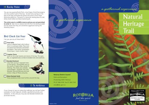
14 Rocky PointYou are now passing Rocky Point, a low finger of land that projectsinto the southern part of the bay. Ancient silica springs on thebed of the lake cemented the gravel and sand to form thesedistinctive platforms. The point is a favourite nesting place for redbilled,black-billed and black-backed gulls.The entire area is a wildlife reserve and you are not permittedto enter it. Take time to observe bird life from the blind providedbut be aware that they are sometimes aggressive during thebreeding season.Bird Check List FourCan you see any of these birds?Pied Stiltshave an adapted beak which allowsthem to scavenge widely. They roostand feed here between Decemberand March. Their name ‘himantopushimantopus’ means leather legs!Caspian Ternsroost on the small islands and shores of the bay. The open,flat, un-vegetated area is similar to braided rivers and seashores.Banded Dotterelraise their young in exposed nestson the barren, inhospitable area tothe south of Sulphur Bay named TeArikiroa. The chicks are carefullycamouflaged. Dotterels nest herebetween July and February and overwinter in Bay of Plenty estuaries.Black Backed Gullsthese predatory birds roost further around the bay.15 Te Arikiroaa geothermal experience<strong>Rotorua</strong> District CouncilParks and RecreationPrivate Bag 3029 <strong>Rotorua</strong>Ph 07 348 4199 Fax 07 346 3143email@rdc.govt.nza geothermal experience<strong>Natural</strong><strong>Heritage</strong><strong>Trail</strong>If you choose to carry on along the walkway, you will see furtherexamples of sinter deposits, birdlife, geothermal activity andwetlands. In this area you may also see Banded Dotterel andprostrate kanuka.Marathon 15342
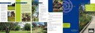
<strong>Natural</strong> <strong>Heritage</strong> <strong>Trail</strong>Take the trail around the shores of Lake <strong>Rotorua</strong> anddelve into the story of a landscape created by volcanicactivity. See plants and birds that have been adaptedto this sulphurous environment and learn about our fieryand fascinating past.1 LakefrontThe peaceful and wellmaintainedpromenadearound this portion of thelake belies a fascinatinghistory that reaches back200,000 years!Lake <strong>Rotorua</strong> has formedin a caldera, the sunkencrater of a vast volcaniceruption that spewed 220cubic kilometres of material over the surrounding land.The oldest continuous lake in New Zealand, it has risen and fallenover millennia. One hundred years ago, this was a marshy bay linedwith raupo (native reed) and a haven for birds.Canoe moored amongst the raupo,c. 1900 - E W Payton, <strong>Rotorua</strong> MuseumREMEMBER: Please don’t feed the birds.Black swans often attack people.Bird Check List OneCan you see any of these birds?Maori found the areauseful as a place to moorcanoes and named thearea Kouramawhitiwhiti.Today much of the landyou walk on has beenreclaimed from the lake.The row of large Planetrees (Platanus orientalis)behind the playgroundmarks the original lakeedge. These trees are overone hundred years old.Black BilledGullRed Billed Gull (tarapunga)This bird is found widely in the Southern Hemisphereand is the commonest of the three gulls found in New Zealand.The red billed gull are bold scavengers.Black SwanThese birds were imported from Australia as an ornamentalwaterfowl. They prefer shallow water for feeding.Mallard DucksMallard ducks are also introduced and widely distributedthroughout New Zealand.GeeseBossy domestic geese have formed a colony along the lakefront.2 Wetland Walkwayto MotutaraFollow the path toMotutara Point anddiscover features of thiswetland habitat. Youwill pass stands ofKanuka and Manuka.Kanuka (Kunzeaericoides) prefers dryManukaland and grows to forma spreading tree up to 20 metres tall. Manuka (Leptospermumscoparium) enjoys wet conditions. How do you tell the difference?The easiest way is to look at the flowers and seed capsules.Kanuka has tiny cream flowers and small seed capsules, whilstManuka has larger white flowers and broad capsules.An unusual and rare prostrate Kanuka grows on thermal soils insome areas. Many of the Manuka and Kanuka trees are encrustedwith orange or black fungus called sooty mould. This grows onthe sweet honeydew excreted by tiny sap sucking insects.3 Rocky OutcropsYou will see a largenumber of platform-likesinter formationsaround the lake shore.Geothermal waterspercolating quartzsediments from deepunderground solidifiedto form them some7000 years ago whenthe lake level was 80 metres higher. The large rock on your rightis called Te Papa-o Te Arawa. This large sinter formation was oncethe site of an urupa (burial ground) but was later quarried toprovide rock for building projects at Ohinemutu.
4 Ferns, Mosses andMarsh Grasses5Much of the lake shoreis either too steep or toosandy for wetlandplants. However, theythrive in this damp areaand include raupo(Typha orientalis) andgiant spike rush.Among the ferns that grow in abundance along the trail aremembers of the marshy-ground loving Histiopteris and Hypolepisfamilies. Examples of clubmosses may be found along the trail.You will also see bracken fern (rahurahu).The starchy root ‘aruhe’ was an important food source to Maoriwhen other food supplies were low. The root took muchpreparation to make it edible.100 year oldtrees thatmark the lakeedge beforereclamation ofthe foreshore1243Manuka & Kanuka ForestTe Papa o Te ArawaSinter outcrops68Bird Check List TwoKanuka ForestTe ParakiriO HinemaruCan you see any of these birds? Spot the ‘new comers’ to our land:Blackbird Song Thrush Chaffinch109Goldfinch Yellowhammer Welcome Swallow5 Motutara PointMalfroy Geyser(built over Chameleonand Oruawhata Springs)Viewing blind1112Te KauangaGeothermalActivityBEWARETake your time as you walk through this area to locate the lavadomes that formed after the initial eruption. Mokoia Island sitsjewel-like in the middle of Lake <strong>Rotorua</strong> while to your left you cansee Ngongotaha Mountain and to your right, Hinemoa Point. Lookfor the shadowy ‘terrace’ that runs around the hills about half wayto the brow denoting the lake-level change around 140,000 yearsago. Mokoia Island and Hinemoa Point feature in a great Te Arawalove story, that of Tutanekai and Hinemoa. Forbidden to meet,Hinemoa swam to her lover on Mokoia Island.Today the island is a wildlife refuge where endangered birds, suchas the North Island Robin, Saddleback and Weka are flourishing.Tradition tells that the Motutara area was inhabited and cultivatedfor many generations. Remnants of defensive earthworks could beseen up until 1890s.Whangapipiro(Rachel Pool)Sulphur Lake131413Rocky PointWildlife RefugeNO ENTRYSulphur BayThe birds of Motutara IslandTake note of the shag nests in the trees on this island. You mayidentify black shags, pied shags and little black shags. Shags stayunderwater for long periods and dive to great depths thanks totheir feature structure which allows water to penetrate quickly –allowing them to sink easily. You may see shags sitting with outspreadwings, waiting for their wings to dry.6 Sulphur BayAs you follow the trailaround the lakeshore, notethat the lake waterbecomes increasingly milky.You are now entering aunique ecological zonewhere plant and bird lifehave adapted to the harshsulphur-laden environment.The bay lies on top of anactive geothermal field and the shallow and highly acidic water isvery low in oxygen. Because of this there is little food for birds sothey leave the area each day to feed. Despite this, many speciesroost and nest on the shores and islets around the bay. Sometimesthe acidic water dissolves the webs between birds’ toes!It is not unusual to see dead birds around this area of the lake shore.Some experts believe they may be victims of botulism, but it ispossible that they have been asphyxiated by high levels of carbondioxide and hydrogen sulphide.7 Trees and PlantsDon’t miss our NewZealand Christmas Tree,Pohutukawa(Metrosideros excelsa, amember of the Myrtlefamily). In December iterupts in brilliant redflowers. Legend tells thatHatupatu, an Arawacultural hero, planted pohutukawa trees around the lakeside andMokoia Island. You will also see a variety of introduced species suchas willow, eucalyptus and wattle.Look for examples of flax (Phormium tenax) known to Maori asharakeke. They named 60 varieties and found numerous uses forthis valued plant, including cloaks made from its fine fibres (muka).Bird Check List ThreeCan you see any of these birds?PukekosYou may have seen our comicalblue and black swamp hensstrolling around the gardens.Members of the rail family, theirdiet is mainly vegetarian.You may choose to leave the trail here (adjacentto the car park a the Lake Plaza Hotel) or explorefurther by following the trail to the PuarengaStream and then on to Wkakarewarewa.Collect a copy of the ROTORUA WALKWAYSbrochure to assist you along this route.Remember: take only photographs andleave only footprints.Timanga was once much larger and supported a number of Maorifamilies. Today Motutere is the larger and home to black shags.Many years ago it boasted a big clear alkaline pool “Hinemaru”named for the mother of Hinemoa. The pool was known for itstherapeutic properties.9 Geothermal WatersThis area is noted for itsgeothermal activity.You may see examples ofgeysers, hot springs,fumaroles and mud pools.Be aware that this areais dangerous. You areadvised to stay on thepath at all times!8 Timanga and Motutere Islands 10 Remnants of a Fiery PastGeysers and Hot Pools develop when hot chloride-laden waterfrom deep underground rises along a zone of weakness in theearth’s crust.Fumaroles occur when trapped boiling underground water isreleased as steam or gas through a vent.Mud Pools happen when the water is trapped at a shallow levelfor some time and reacts chemically with the soil around it, releasingsulphuric acid.The soft, soapy-feeling water of alkaline chloride pools is clear andvery hot, whilst the acidic sulphate waters from hot pools are cloudyor ‘muddy’. These sulphurous, acidic waters are the source of<strong>Rotorua</strong>’s well known ‘rotten-egg’ smell. The bubbles in mud poolscome from the escaping gases.DabchicksThese are a New Zealand native grebe. Found only in the NorthIsland, they are a small, dark bird with a chestnut-colouredbreast and bright eye. <strong>Rotorua</strong> is a haven for these endangeredbirds: 500 breeding pairs have been identified but only around100 live here year-round.ScaupThe small dark duck with a high domedforehead and rounded bill is the NewZealand scaup (papango). They are our onlytrue diving duck, diving up to two metres.Sinter depositsGeothermal algaeGeothermal activityand sulphur mounds15As you walk along the beach towards the boardwalks you willsee examples of pumice, a light soft lava. Geologists tell us thispumice came from a volcanic vent in the area of the Blue andGreen lakes. You may also see examples of red, black or greyscoria, further examples of lava. The blackened wood and trunksof fallen manuka and kanuka have been ‘burnt’ by hydrogensulphide. Even the tanalised pine walkway is turning black!11 The Coffee PotTe ArikiroaWetland vegetationThis murky bubbling brown pool was once a sought-after thermalattraction. People tied ropes to the manuka bushes and loweredthemselves into the soupy liquid. Notice that the acid water eatsaway the surrounding soil and incorporates it into the pool.12 Cameron’s Laughing Gas PoolWould you like to bathe in this muddy hole?Maori people used it and later so did Europeans who travelledgreat distances to this spot! The action of bubbles rising to thesurface gives the impression that the water is boiling. Evidently,people experienced fits of laughter when bathing here.13 Craters Formed by EruptionsThe two circular craters either side of Rocky Point were formedby geothermal explosions. A dramatic change in lake levelscaused by rapid draining or a volcanic eruption produced pressurechanges underground. This caused violent geothermal explosionscreating the two deep craters that define this area.