- Page 4 and 5: Directions to Use the DocumentDurin
- Page 7 and 8: V.4.G Daily Transmission of rainfal
- Page 9 and 10: List of TablesTable No. Table Page
- Page 11 and 12: Standard Operating Prcedure, before
- Page 13 and 14: 18 Setting up of Gumshuda TalaashKe
- Page 15 and 16: Power Supply ------do------- During
- Page 17 and 18: embankments, roads etc whichare usu
- Page 19 and 20: liaison with railwaysInspection of
- Page 21 and 22: Chapter IGeneralI. 1. Title: This p
- Page 23 and 24: Chapter IIDistrict ProfileII.1 Admi
- Page 26 and 27: 6 (b) House Use: Majority of the oc
- Page 28 and 29: Table no 12. Effects of Earthquake
- Page 30 and 31: the Delhi-Hardiwar Ridge, the Lahor
- Page 34 and 35: [34]
- Page 36 and 37: Table No 15 Past trends of floods i
- Page 38 and 39: 2. The area of Faridabad complex: I
- Page 40 and 41: Potholes on roads and inappropriate
- Page 42 and 43: 5 (b) Risk of Industrial Disasters
- Page 44 and 45: 5 (c) Population Vulnerable to Indu
- Page 46 and 47: with sand. Approach road for the pl
- Page 48 and 49: Standard Operating Procedure for re
- Page 50 and 51: III.9. Epidemics: Epedimic control
- Page 52 and 53: 8. Filling of mud pits and channels
- Page 54 and 55: Chapter IVInstitutional Structure f
- Page 56 and 57: up which shall function round the c
- Page 58 and 59: IV.5 District Disaster Resource Hub
- Page 60 and 61: Chapter VPreparedness PlanV.1. Prep
- Page 62 and 63: 2. Establishment of people centered
- Page 65 and 66: 10 Structural Safety for Earthquake
- Page 67 and 68: Accidents sector of the district to
- Page 69 and 70: FireEstablishment of fire stations
- Page 71 and 72: V.4.K. Identification of private bo
- Page 73 and 74: 9 Sri Daya Chand Rohilla, SSE 220 K
- Page 75 and 76: VI.1. Logistics Preparedness PlanCh
- Page 77 and 78: commodities at vendors end will be
- Page 79 and 80: VI.2. (D) (v) Relief assistance man
- Page 81 and 82: (a)(b)Distribution Centre is least
- Page 83 and 84:
(b) It is expected that people, wil
- Page 85 and 86:
Table No. 29 Delegation of Powers u
- Page 87 and 88:
the nature and magnitude of the los
- Page 89 and 90:
Chapter VIIIResponse PlanVIII. 1. I
- Page 91 and 92:
Fig 11 Incident Response SytemPlann
- Page 93 and 94:
7. RO will ensure that the line dep
- Page 95 and 96:
VIII. 2. (D) Trainings and Rescue E
- Page 97 and 98:
B. Incident Safety and Chaos manage
- Page 99 and 100:
timely. It is expected that even in
- Page 101 and 102:
Flow Charts below, depicts the Inte
- Page 103 and 104:
D. He should also ensure that human
- Page 105 and 106:
Chapter IXResource InventoryContent
- Page 107 and 108:
DCP Crime Sh. Sajjan Kumar 95822001
- Page 109 and 110:
5. Fire Officer Sh. Mahaveer Singh
- Page 111 and 112:
Ballabhgarh Sh. V.K. Agarwal H.No.
- Page 113 and 114:
DPC- SSA (Sarwa Smt Alok Saxena 989
- Page 115 and 116:
7 Escorts Hospital & Research Centr
- Page 117 and 118:
Fire Equipments with the Industries
- Page 119 and 120:
Group No-9 Sh. Tej Singh (GL) Fire
- Page 121 and 122:
9 M/s. Demaco Polymers LTD, P.No.-8
- Page 123 and 124:
Analgesic and Anesthetic Agents30.
- Page 125 and 126:
127. Torch with batteries128. Misce
- Page 127 and 128:
3 O.B.M. 01 01 024 Trailor - 01 015
- Page 129 and 130:
-129-
- Page 131 and 132:
Annexure 1. Refered in Section III.
- Page 133 and 134:
Old ListRecommended ListSN Dangerou
- Page 135 and 136:
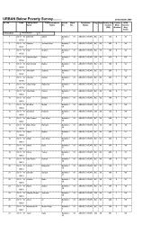
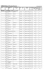
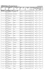
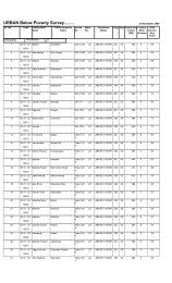
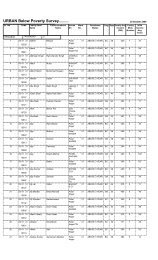
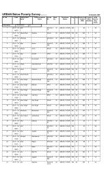
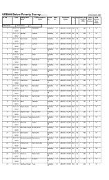
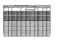
BallabhgarhIndira Colony Jhuggies a
- Page 137 and 138:
Annexure 04, Referred in section V.
- Page 139 and 140:
Annexure 05, Referred in Section VI
- Page 141 and 142:
Name of housesaffected with extent
- Page 143 and 144:
FullyPartially8 Estimate Value of D
- Page 145 and 146:
ation ( for 2weeks )fuel / and uten
- Page 147 and 148:
घरेलू आपातका