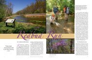
2013 Virginia Freshwater Fishing & Watercraft Owner's Guide
2013 Virginia Freshwater Fishing & Watercraft Owner's Guide
2013 Virginia Freshwater Fishing & Watercraft Owner's Guide

You also want an ePaper? Increase the reach of your titles
YUMPU automatically turns print PDFs into web optimized ePapers that Google loves.
<strong>2013</strong> <strong>Fishing</strong> Regs & WOG 11-15-12_Layout 1 11/16/12 1:01 PM Page 22Special Regulation TroutWatersJackson River Tailwater (Allegheny County):From Gathright Dam downstream to theWestvaco Dam at Covington: No rainbowtrout 12 to 16 inches; no brown trout lessthan 20 inches; 4 trout (combined rainbowand brown) creel (harvest) limit per day, only1 of 4 can be a brown trout over 20 inches.All rainbow trout between 12 and 16 inchesand all brown trout less than 20 inches mustbe released immediately. The 7-inchstatewide minimum size limit does not applyto rainbow trout in this section of river.Lake Moomaw (Alleghany/Bath counties):The entire reservoir has the special 16-inchminimum size limit and 2 fish per day creellimit on trout.Smith River (Henry County): From PhilpottDam downstream to the State Route 636Bridge crossing (Mitchell Bridge) locatedapproximately 31 miles downstream ofPhilpott Dam and approximately 10.5 milesbelow Martinsville Dam: No brown trout 10to 24 inches, only 1 brown trout per daylonger than 24 inches. The length limit forrainbow and brook trout is 7 inch minimum.The creel limit for all trout combined is 6fish/day, and only one brown trout can belarger than 24 inches. The use of bait andany combination of artificial lure is allowedthroughout this section of river.South Holston Reservoir (WashingtonCounty): 7 per day creel (harvest) limit, only2 of 7 can be a Lake trout; no length limits(see licenses and regulations in the reciprocalsection on pages 8–9).Regulations for the special 9-inch,12-inch, 16-inch/2, 20-inch/1, andcatch & release trout streamsections that follow:a. Only single point hook artificial luresmay be used unless otherwise noted.(See artificial lure definition above.)b. No bait may be in possession while fishingthese waters unless otherwise noted.c. All trout less than the minimum sizemust be immediately returned to thewater unharmed. No trout less than theminimum size may be in possessionwhile fishing in these waters.9-inch MinimumBig and Little Wilson Creeks and their tributaries,Quebec Branch, Wilburn Branch andMill Creek (Grayson County): That portionwithin the Grayson Highlands State Park andthe Jefferson National Forest Mount RogersNational Recreation Area. With the specialregulation on Cabin Creek (see below), all ofthe streams within Grayson Highlands StatePark are under one regulation. Access can begained through Grayson Highlands StatePark on Route 806 and 817 off U.S. Route 58.Be prepared to do some hiking to fish thisarea.Cabin Creek (Grayson County): That portionof stream and its tributaries within theGrayson Highlands State Park and the JeffersonNational Forest Mount Rogers NationalRecreation Area. See above for more informationon the area.Conway River/Devils Ditch (Greene andMadison counties): That portion of ConwayRiver and its major tributary, Devils Ditch,within the Rapidan Wildlife ManagementArea and the Shenandoah National Park.The stream lies north of Stanardsville andcan be reached by Route 615 from GravesMill.Garth Run (Madison County): That portionof stream within the Rapidan WildlifeManagement Area. The stream can bereached by Route 615 from Graves Mill.Most of the stream is accessible only byfoot as the streams enters a gorge.Little Stony Creek (Giles County): That portionof stream within the Jefferson NationalForest. The stream is located near Pembrokeand can be reached by Route 623.Little Stony Creek (Shenandoah County):That portion of stream within the GeorgeWashington National Forest, includingWoodstock Reservoir. The stream is locatedwest of Woodstock and the Forest ServiceRoad 92 crosses the lower portion of thespecial regulation section. Much of theupper reaches can only be reached by foottrail.Mill Creek (Giles County): That portion ofMill Creek and its tributaries upstream of thePoplar Street Bridge in the Town of Narrows(Mill Creek flows through the NationalForest in Giles County and the Town ofNarrows.) The stream can be accessed froma parking area on Northview Street, off ofState Route 100, south of Narrows.North Fork Buffalo River (Amherst County):That portion of the stream and its tributarieswithin the George Washington NationalForest. Access is available by a forest trail offForest Road 51 or from the end of StateRoute 635.St. Mary’s River (Augusta County): All portionsof stream and its tributaries above thegate near the George Washington NationalForest property line. The stream lies east ofRaphine off Route 608, a short distance fromI-81. Most of the area is accessible by foottrail only and backpacking is popular.Ramsey’s Draft (Augusta County): That portionof the stream and its tributaries withinthe George Washington National Forest. Toreach this stream, drive 15 miles west ofChurchville on Route 250 and look for theMountain Home Picnic Area on the right; afoot trail parallels the stream from the picnicarea.12-inch MinimumSnake Creek (Carroll County): All of BigSnake Creek below Hall Ford and all of LittleSnake Creek below the junction of Routes922 and 674. These streams are located justnorth of Fancy Gap.Smith Creek (Alleghany County): Thatportion from the Clifton Forge Dam downstreamto a sign at the Forest Service boundaryabove the C & O Dam. Best streamaccess is by Route 606 from Clifton Forge tothe Clifton Forge Water Plant access road;anglers must park at the entrance and walka half mile to the stream.Whitetop Laurel/Green Cove Creeks(Washington County):Whitetop Laurel (2 sections)—that portionupstream from the first railroad trestleabove Taylor Valley to the mouth of GreenCove Creek at Creek Junction and that portionupstream from the mouth of StraightBranch to a sign at the Forest Service boundaryjust downstream of Taylor Valley;Green Cove Creek—that portion from Rt.859 downstream to its mouth. Thereremains a section of catchable stocked troutwater without special regulations throughthe village of Taylors Valley. The specialregulation area is located east of Damascus(near the Tennessee line) and lies within theMount Rogers Recreation Area.16-inch Minimum,2 Fish Per Day*Buffalo Creek (Rockbridge County): Thatportion from the confluence of Collier’sCreek upstream 2.9 miles to the confluenceof North and South Buffalo creeks. Thestream flows through private land and *afree written landowner permit is requiredto fish these waters. A no cost permit, map,and additional information for this stream22 <strong>2013</strong> <strong>Virginia</strong> <strong>Freshwater</strong> <strong>Fishing</strong> & Boating <strong>Guide</strong>