varieties creation and conservation of plant genetic resources
varieties creation and conservation of plant genetic resources
varieties creation and conservation of plant genetic resources

You also want an ePaper? Increase the reach of your titles
YUMPU automatically turns print PDFs into web optimized ePapers that Google loves.
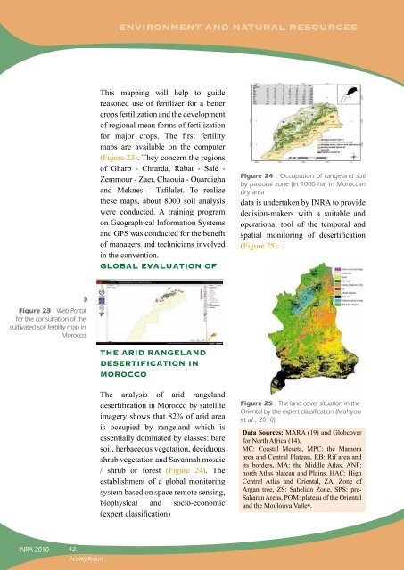
Figure 23 : Web Portal<br />
for the consultation <strong>of</strong> the<br />
cultivated soil fertility map in<br />
Morocco<br />
INRA 2010<br />
42<br />
Activity Report<br />
ENVIRONMENT AND NATURAL RESOURCES<br />
This mapping will help to guide<br />
reasoned use <strong>of</strong> fertilizer for a better<br />
crops fertilization <strong>and</strong> the development<br />
<strong>of</strong> regional mean forms <strong>of</strong> fertilization<br />
for major crops. The first fertility<br />
maps are available on the computer<br />
(Figure 23). They concern the regions<br />
<strong>of</strong> Gharb - Chrarda, Rabat - Salé -<br />
Zemmour - Zaer, Chaouia - Ouardigha<br />
<strong>and</strong> Meknes - Tafilalet. To realize<br />
these maps, about 8000 soil analysis<br />
were conducted. A training program<br />
on Geographical Information Systems<br />
<strong>and</strong> GPS was conducted for the benefit<br />
<strong>of</strong> managers <strong>and</strong> technicians involved<br />
in the convention.<br />
GLOBAL EVALUATION OF<br />
THE ARID RANGELAND<br />
DESERTIFICATION IN<br />
MOROCCO<br />
The analysis <strong>of</strong> arid rangel<strong>and</strong><br />
desertification in Morocco by satellite<br />
imagery shows that 82% <strong>of</strong> arid area<br />
is occupied by rangel<strong>and</strong> which is<br />
essentially dominated by classes: bare<br />
soil, herbaceous vegetation, deciduous<br />
shrub vegetation <strong>and</strong> Savannah mosaic<br />
/ shrub or forest (Figure 24). The<br />
establishment <strong>of</strong> a global monitoring<br />
system based on space remote sensing,<br />
biophysical <strong>and</strong> socio-economic<br />
(expert classification)<br />
Figure 24 : Occupation <strong>of</strong> rangel<strong>and</strong> soil<br />
by pastoral zone (in 1000 ha) in Moroccan<br />
dry area<br />
data is undertaken by INRA to provide<br />
decision-makers with a suitable <strong>and</strong><br />
operational tool <strong>of</strong> the temporal <strong>and</strong><br />
spatial monitoring <strong>of</strong> desertification<br />
(Figure 25).<br />
Figure 25 : The l<strong>and</strong> cover situation in the<br />
Oriental by the expert classification (Mahyou<br />
et al., 2010).<br />
Data Sources: MARA (19) <strong>and</strong> Globcover<br />
for North Africa (14).<br />
MC: Coastal Meseta, MPC: the Mamora<br />
area <strong>and</strong> Central Plateau, RB: Rif area <strong>and</strong><br />
its borders, MA: the Middle Atlas, ANP:<br />
north Atlas plateau <strong>and</strong> Plains, HAC: High<br />
Central Atlas <strong>and</strong> Oriental, ZA: Zone <strong>of</strong><br />
Argan tree, ZS: Sahelian Zone, SPS: pre-<br />
Saharan Areas, POM: plateau <strong>of</strong> the Oriental<br />
<strong>and</strong> the Moulouya Valley.