

State County Location Name Latitude Longitude ... - Insects of Iowa
State County Location Name Latitude Longitude ... - Insects of Iowa
State County Location Name Latitude Longitude ... - Insects of Iowa

Create successful ePaper yourself
Turn your PDF publications into a flip-book with our unique Google optimized e-Paper software.
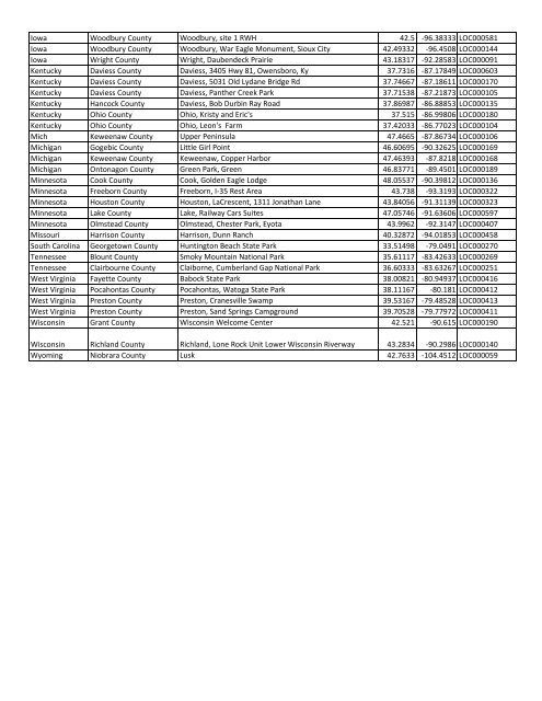
<strong>Iowa</strong> Woodbury <strong>County</strong> Woodbury, site 1 RWH 42.5 -96.38333 LOC000581<strong>Iowa</strong> Woodbury <strong>County</strong> Woodbury, War Eagle Monument, Sioux City 42.49332 -96.4508 LOC000144<strong>Iowa</strong> Wright <strong>County</strong> Wright, Daubendeck Prairie 43.18317 -92.28583 LOC000091Kentucky Daviess <strong>County</strong> Daviess, 3405 Hwy 81, Owensboro, Ky 37.7316 -87.17849 LOC000603Kentucky Daviess <strong>County</strong> Daviess, 5031 Old Lydane Bridge Rd 37.74667 -87.18611 LOC000170Kentucky Daviess <strong>County</strong> Daviess, Panther Creek Park 37.71538 -87.21873 LOC000105Kentucky Hancock <strong>County</strong> Daviess, Bob Durbin Ray Road 37.86987 -86.88853 LOC000135Kentucky Ohio <strong>County</strong> Ohio, Kristy and Eric's 37.515 -86.99806 LOC000180Kentucky Ohio <strong>County</strong> Ohio, Leon's Farm 37.42033 -86.77023 LOC000104Mich Keweenaw <strong>County</strong> Upper Peninsula 47.4665 -87.86734 LOC000106Michigan Gogebic <strong>County</strong> Little Girl Point 46.60695 -90.32625 LOC000169Michigan Keweenaw <strong>County</strong> Keweenaw, Copper Harbor 47.46393 -87.8218 LOC000168Michigan Ontonagon <strong>County</strong> Green Park, Green 46.83771 -89.4501 LOC000189Minnesota Cook <strong>County</strong> Cook, Golden Eagle Lodge 48.05537 -90.39812 LOC000136Minnesota Freeborn <strong>County</strong> Freeborn, I-35 Rest Area 43.738 -93.3193 LOC000322Minnesota Houston <strong>County</strong> Houston, LaCrescent, 1311 Jonathan Lane 43.84056 -91.31139 LOC000323Minnesota Lake <strong>County</strong> Lake, Railway Cars Suites 47.05746 -91.63606 LOC000597Minnesota Olmstead <strong>County</strong> Olmstead, Chester Park, Eyota 43.9962 -92.3147 LOC000407Missouri Harrison <strong>County</strong> Harrison, Dunn Ranch 40.32872 -94.01853 LOC000458South Carolina Georgetown <strong>County</strong> Huntington Beach <strong>State</strong> Park 33.51498 -79.0491 LOC000270Tennessee Blount <strong>County</strong> Smoky Mountain National Park 35.61117 -83.42633 LOC000269Tennessee Clairbourne <strong>County</strong> Claiborne, Cumberland Gap National Park 36.60333 -83.63267 LOC000251West Virginia Fayette <strong>County</strong> Babock <strong>State</strong> Park 38.00821 -80.94937 LOC000416West Virginia Pocahontas <strong>County</strong> Pocahontas, Watoga <strong>State</strong> Park 38.11167 -80.181 LOC000412West Virginia Preston <strong>County</strong> Preston, Cranesville Swamp 39.53167 -79.48528 LOC000413West Virginia Preston <strong>County</strong> Preston, Sand Springs Campground 39.70528 -79.77972 LOC000411Wisconsin Grant <strong>County</strong> Wisconsin Welcome Center 42.521 -90.615 LOC000190Wisconsin Richland <strong>County</strong> Richland, Lone Rock Unit Lower Wisconsin Riverway 43.2834 -90.2986 LOC000140Wyoming Niobrara <strong>County</strong> Lusk 42.7633 -104.4512 LOC000059
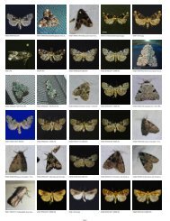
![District State [Species]Genus SpeciesName ... - Insects of Iowa](https://img.yumpu.com/12292306/1/190x146/district-state-speciesgenus-speciesname-insects-of-iowa.jpg?quality=85)