

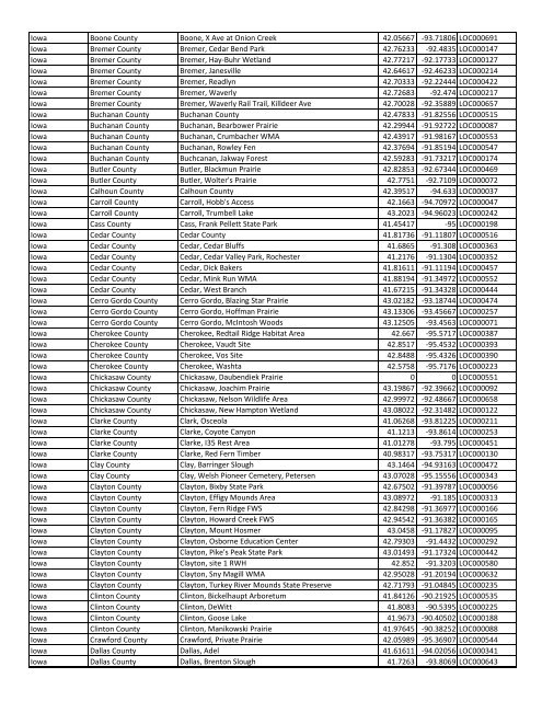
State County Location Name Latitude Longitude ... - Insects of Iowa
State County Location Name Latitude Longitude ... - Insects of Iowa
State County Location Name Latitude Longitude ... - Insects of Iowa

Create successful ePaper yourself
Turn your PDF publications into a flip-book with our unique Google optimized e-Paper software.
<strong>Iowa</strong> Boone <strong>County</strong> Boone, X Ave at Onion Creek 42.05667 -93.71806 LOC000691<strong>Iowa</strong> Bremer <strong>County</strong> Bremer, Cedar Bend Park 42.76233 -92.4835 LOC000147<strong>Iowa</strong> Bremer <strong>County</strong> Bremer, Hay-Buhr Wetland 42.77217 -92.17733 LOC000127<strong>Iowa</strong> Bremer <strong>County</strong> Bremer, Janesville 42.64617 -92.46233 LOC000214<strong>Iowa</strong> Bremer <strong>County</strong> Bremer, Readlyn 42.70333 -92.22444 LOC000422<strong>Iowa</strong> Bremer <strong>County</strong> Bremer, Waverly 42.72683 -92.474 LOC000217<strong>Iowa</strong> Bremer <strong>County</strong> Bremer, Waverly Rail Trail, Killdeer Ave 42.70028 -92.35889 LOC000657<strong>Iowa</strong> Buchanan <strong>County</strong> Buchanan <strong>County</strong> 42.47833 -91.82556 LOC000515<strong>Iowa</strong> Buchanan <strong>County</strong> Buchanan, Bearbower Prairie 42.29944 -91.92722 LOC000087<strong>Iowa</strong> Buchanan <strong>County</strong> Buchanan, Crumbacher WMA 42.43917 -91.98167 LOC000553<strong>Iowa</strong> Buchanan <strong>County</strong> Buchanan, Rowley Fen 42.37694 -91.85194 LOC000547<strong>Iowa</strong> Buchanan <strong>County</strong> Buchcanan, Jakway Forest 42.59283 -91.73217 LOC000174<strong>Iowa</strong> Butler <strong>County</strong> Butler, Blackmun Prairie 42.82853 -92.67344 LOC000469<strong>Iowa</strong> Butler <strong>County</strong> Butler, Wolter's Prairie 42.7751 -92.7109 LOC000072<strong>Iowa</strong> Calhoun <strong>County</strong> Calhoun <strong>County</strong> 42.39517 -94.633 LOC000037<strong>Iowa</strong> Carroll <strong>County</strong> Carroll, Hobb's Access 42.1663 -94.70972 LOC000047<strong>Iowa</strong> Carroll <strong>County</strong> Carroll, Trumbell Lake 43.2023 -94.96023 LOC000242<strong>Iowa</strong> Cass <strong>County</strong> Cass, Frank Pellett <strong>State</strong> Park 41.45417 -95 LOC000198<strong>Iowa</strong> Cedar <strong>County</strong> Cedar <strong>County</strong> 41.81736 -91.11807 LOC000516<strong>Iowa</strong> Cedar <strong>County</strong> Cedar, Cedar Bluffs 41.6865 -91.308 LOC000363<strong>Iowa</strong> Cedar <strong>County</strong> Cedar, Cedar Valley Park, Rochester 41.2176 -91.1304 LOC000352<strong>Iowa</strong> Cedar <strong>County</strong> Cedar, Dick Bakers 41.81611 -91.11194 LOC000457<strong>Iowa</strong> Cedar <strong>County</strong> Cedar, Mink Run WMA 41.88194 -91.34972 LOC000552<strong>Iowa</strong> Cedar <strong>County</strong> Cedar, West Branch 41.67215 -91.34328 LOC000444<strong>Iowa</strong> Cerro Gordo <strong>County</strong> Cerro Gordo, Blazing Star Prairie 43.02182 -93.18744 LOC000474<strong>Iowa</strong> Cerro Gordo <strong>County</strong> Cerro Gordo, H<strong>of</strong>fman Prairie 43.13306 -93.45667 LOC000257<strong>Iowa</strong> Cerro Gordo <strong>County</strong> Cerro Gordo, McIntosh Woods 43.12505 -93.4563 LOC000071<strong>Iowa</strong> Cherokee <strong>County</strong> Cherokee, Redtail Ridge Habitat Area 42.667 -95.5717 LOC000387<strong>Iowa</strong> Cherokee <strong>County</strong> Cherokee, Vaudt Site 42.8517 -95.4532 LOC000393<strong>Iowa</strong> Cherokee <strong>County</strong> Cherokee, Vos Site 42.8488 -95.4326 LOC000390<strong>Iowa</strong> Cherokee <strong>County</strong> Cherokee, Washta 42.5758 -95.7176 LOC000223<strong>Iowa</strong> Chickasaw <strong>County</strong> Chickasaw, Daubendiek Prairie 0 0 LOC000551<strong>Iowa</strong> Chickasaw <strong>County</strong> Chickasaw, Joachim Prairie 43.19867 -92.39662 LOC000092<strong>Iowa</strong> Chickasaw <strong>County</strong> Chickasaw, Nelson Wildlife Area 42.99972 -92.48667 LOC000658<strong>Iowa</strong> Chickasaw <strong>County</strong> Chickasaw, New Hampton Wetland 43.08022 -92.31482 LOC000122<strong>Iowa</strong> Clarke <strong>County</strong> Clark, Osceola 41.06268 -93.81225 LOC000211<strong>Iowa</strong> Clarke <strong>County</strong> Clarke, Coyote Canyon 41.1213 -93.8614 LOC000253<strong>Iowa</strong> Clarke <strong>County</strong> Clarke, I35 Rest Area 41.01278 -93.795 LOC000451<strong>Iowa</strong> Clarke <strong>County</strong> Clarke, Red Fern Timber 40.98317 -93.75317 LOC000130<strong>Iowa</strong> Clay <strong>County</strong> Clay, Barringer Slough 43.1464 -94.93163 LOC000472<strong>Iowa</strong> Clay <strong>County</strong> Clay, Welsh Pioneer Cemetery, Petersen 43.07028 -95.15556 LOC000343<strong>Iowa</strong> Clayton <strong>County</strong> Clayton, Bixby <strong>State</strong> Park 42.67502 -91.39787 LOC000056<strong>Iowa</strong> Clayton <strong>County</strong> Clayton, Effigy Mounds Area 43.08972 -91.185 LOC000313<strong>Iowa</strong> Clayton <strong>County</strong> Clayton, Fern Ridge FWS 42.84298 -91.36977 LOC000166<strong>Iowa</strong> Clayton <strong>County</strong> Clayton, Howard Creek FWS 42.94542 -91.36382 LOC000165<strong>Iowa</strong> Clayton <strong>County</strong> Clayton, Mount Hosmer 43.0458 -91.17827 LOC000095<strong>Iowa</strong> Clayton <strong>County</strong> Clayton, Osborne Education Center 42.79303 -91.4432 LOC000292<strong>Iowa</strong> Clayton <strong>County</strong> Clayton, Pike's Peak <strong>State</strong> Park 43.01493 -91.17324 LOC000442<strong>Iowa</strong> Clayton <strong>County</strong> Clayton, site 1 RWH 42.852 -91.3203 LOC000580<strong>Iowa</strong> Clayton <strong>County</strong> Clayton, Sny Magill WMA 42.95028 -91.20194 LOC000632<strong>Iowa</strong> Clayton <strong>County</strong> Clayton, Turkey River Mounds <strong>State</strong> Preserve 42.71793 -91.04845 LOC000235<strong>Iowa</strong> Clinton <strong>County</strong> Clinton, Bickelhaupt Arboretum 41.84126 -90.21925 LOC000535<strong>Iowa</strong> Clinton <strong>County</strong> Clinton, DeWitt 41.8083 -90.5395 LOC000225<strong>Iowa</strong> Clinton <strong>County</strong> Clinton, Goose Lake 41.9673 -90.40502 LOC000188<strong>Iowa</strong> Clinton <strong>County</strong> Clinton, Manikowski Prairie 41.97645 -90.38252 LOC000088<strong>Iowa</strong> Crawford <strong>County</strong> Crawford, Private Prairie 42.05989 -95.36907 LOC000544<strong>Iowa</strong> Dallas <strong>County</strong> Dallas, Adel 41.61611 -94.02056 LOC000341<strong>Iowa</strong> Dallas <strong>County</strong> Dallas, Brenton Slough 41.7263 -93.8069 LOC000643
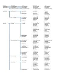
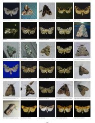
![District State [Species]Genus SpeciesName ... - Insects of Iowa](https://img.yumpu.com/12292306/1/190x146/district-state-speciesgenus-speciesname-insects-of-iowa.jpg?quality=85)