

State County Location Name Latitude Longitude ... - Insects of Iowa
State County Location Name Latitude Longitude ... - Insects of Iowa
State County Location Name Latitude Longitude ... - Insects of Iowa

Create successful ePaper yourself
Turn your PDF publications into a flip-book with our unique Google optimized e-Paper software.
<strong>State</strong> <strong>County</strong> <strong>Location</strong> <strong>Name</strong> <strong>Latitude</strong> <strong>Longitude</strong> <strong>Location</strong> CodeFlorida Collier <strong>County</strong> Collier, Okaloacoochee Slough <strong>State</strong> Forest 26.52946 -81.28685 LOC000593Florida Manatee <strong>County</strong> Bradenton 27.47222 -82.63 LOC000310Florida Manatee <strong>County</strong> Oscar Scherer <strong>State</strong> Park 27.17343 -82.47142 LOC000271Idaho Kootenai <strong>County</strong> Kootenai, Idaho Panhandle National Forest 47.78333 -116.7 LOC000332Indiana Wells <strong>County</strong> Wells, Bluffton In KOA 40.74645 -85.19347 LOC000243<strong>Iowa</strong> Adair <strong>County</strong> Adair, I80 Rest Stop near Adair 41.497 -94.572 LOC000647<strong>Iowa</strong> Adair <strong>County</strong> Adair, site 1 MEM 41.3455 -94.4719 LOC000578<strong>Iowa</strong> Adams <strong>County</strong> Adams, Corning 40.99265 -94.73622 LOC000077<strong>Iowa</strong> Allamakee <strong>County</strong> Allamakee, 1km NW Dorchester Osterholm site 42.47167 -91.51333 LOC000282<strong>Iowa</strong> Allamakee <strong>County</strong> Allamakee, Big Paint Campground Yellow River Forest 43.13753 -91.22503 LOC000111<strong>Iowa</strong> Allamakee <strong>County</strong> Allamakee, Fish Farm Mounds 43.45639 91.27917 LOC000382<strong>Iowa</strong> Allamakee <strong>County</strong> Allamakee, French Creek WMA 43.3927 -91.4107 LOC000608<strong>Iowa</strong> Allamakee <strong>County</strong> Allamakee, Harper's Ferry Levee 43.23257 -91.12287 LOC000112<strong>Iowa</strong> Allamakee <strong>County</strong> Allamakee, Heritage Valley 43.36667 -91.56667 LOC000316<strong>Iowa</strong> Allamakee <strong>County</strong> Allamakee, Lansing 43.362 -91.2169 LOC000222<strong>Iowa</strong> Allamakee <strong>County</strong> Allamakee, Mile Long Prairie 0 0 LOC000567<strong>Iowa</strong> Allamakee <strong>County</strong> Allamakee, Osterholm Site 0 0 LOC000284<strong>Iowa</strong> Allamakee <strong>County</strong> Allamakee, Red Oak 43.27917 -91.33361 LOC000318<strong>Iowa</strong> Allamakee <strong>County</strong> Allamakee, Sand Cove 43.449 -91.301 LOC000694<strong>Iowa</strong> Allamakee <strong>County</strong> Allamakee, site 43.4 -91.56667 LOC000330<strong>Iowa</strong> Allamakee <strong>County</strong> Allamakee, site 2 43.36667 -91.56667 LOC000333<strong>Iowa</strong> Allamakee <strong>County</strong> Allamakee, USFW Office McGregor 43.09197 -91.29475 LOC000266<strong>Iowa</strong> Allamakee <strong>County</strong> Allamakee, Yellow River Forest 43.1375 -91.275 LOC000065<strong>Iowa</strong> Allamakee <strong>County</strong> Allamakee, Yellow River <strong>State</strong> Forest 2 43.11417 -91.23472 LOC000635<strong>Iowa</strong> Allamakee <strong>County</strong> Allamakee, Yellow River <strong>State</strong> Forest 3 43.115 -91.23722 LOC000636<strong>Iowa</strong> Allamakee <strong>County</strong> Appanoose, Honey Creek, Lake Rathburn 40.87333 -92.88983 LOC000119<strong>Iowa</strong> Appanoose <strong>County</strong> Appanoose, Sharon Bluffs <strong>State</strong> Park 40.72057 -92.80018 LOC000080<strong>Iowa</strong> Benton <strong>County</strong> Benton, Atkins 41.995 -91.861 LOC000631<strong>Iowa</strong> Benton <strong>County</strong> Benton, BAMONA site 41.99715 -91.88509 LOC000704<strong>Iowa</strong> Benton <strong>County</strong> Benton, Garrison 42.1801 -92.1576 LOC000268<strong>Iowa</strong> Benton <strong>County</strong> Benton, Minne Estema Park 42.257 -92.0198 LOC000605<strong>Iowa</strong> Benton <strong>County</strong> Benton, Red Fox Wildlife Area 42.22889 -92.03917 LOC000556<strong>Iowa</strong> Black Hawk <strong>County</strong> Black Hawk <strong>County</strong> 42.50556 -92.28556 LOC000514<strong>Iowa</strong> Black Hawk <strong>County</strong> Black Hawk, Cedar Falls 42.5078 -92.4062 LOC000226<strong>Iowa</strong> Black Hawk <strong>County</strong> Black Hawk, Cedar Hills Sand Prairie 42.59305 -92.55315 LOC000054<strong>Iowa</strong> Black Hawk <strong>County</strong> Black Hawk, Dunkerton 42.5701 -92.1607 LOC000116<strong>Iowa</strong> Black Hawk <strong>County</strong> Black Hawk, Edgerton Preserve 42.43528 -92.07417 LOC000555<strong>Iowa</strong> Black Hawk <strong>County</strong> Black Hawk, Franta Wildlife Area 42.43194 -92.07278 LOC000554<strong>Iowa</strong> Black Hawk <strong>County</strong> Black Hawk, George Wyth <strong>State</strong> Park 42.53563 -92.40558 LOC000162<strong>Iowa</strong> Black Hawk <strong>County</strong> Black Hawk, Hartman Reserve 42.52052 -92.38428 LOC000161<strong>Iowa</strong> Black Hawk <strong>County</strong> Black Hawk, UNI Campus, Cedar Falls 42.51444 -92.46361 LOC000349<strong>Iowa</strong> Black Hawk <strong>County</strong> Black Hawk, Waterloo 42.51288 -92.42027 LOC000264<strong>Iowa</strong> Black Hawk <strong>County</strong> Black Hawk, Waterloo Airport 42.54997 -92.3963 LOC000215<strong>Iowa</strong> Boone <strong>County</strong> Boone, 2133 220th 42.05917 -93.88 LOC000414<strong>Iowa</strong> Boone <strong>County</strong> Boone, Boone 42.05972 -93.88 LOC000337<strong>Iowa</strong> Boone <strong>County</strong> Boone, Building Hwy R18 42.03167 -93.95028 LOC000494<strong>Iowa</strong> Boone <strong>County</strong> Boone, Camp Mitigwa 42.06083 -93.91139 LOC000239<strong>Iowa</strong> Boone <strong>County</strong> Boone, Ledges <strong>State</strong> Park 41.9828 -93.8878 LOC000233<strong>Iowa</strong> Boone <strong>County</strong> Boone, Little Bluestem 42.04083 -93.92 LOC000521<strong>Iowa</strong> Boone <strong>County</strong> Boone, Little Bluestem Prairie 0 0 LOC000697<strong>Iowa</strong> Boone <strong>County</strong> Boone, Lloyd Crim 42.05972 -93.88 LOC000194<strong>Iowa</strong> Boone <strong>County</strong> Boone, Madrid 41.8757 -93.82 LOC000589<strong>Iowa</strong> Boone <strong>County</strong> Boone, McHose Park 42.03778 -93.90833 LOC000403<strong>Iowa</strong> Boone <strong>County</strong> Boone, Ogden 42.0395 -94.0318 LOC000698<strong>Iowa</strong> Boone <strong>County</strong> Boone, Seven Oaks Rec Area 42.03028 -93.95306 LOC000404<strong>Iowa</strong> Boone <strong>County</strong> Boone, site 1 Bold 41.983 -93.883 LOC000571
<strong>Iowa</strong> Boone <strong>County</strong> Boone, X Ave at Onion Creek 42.05667 -93.71806 LOC000691<strong>Iowa</strong> Bremer <strong>County</strong> Bremer, Cedar Bend Park 42.76233 -92.4835 LOC000147<strong>Iowa</strong> Bremer <strong>County</strong> Bremer, Hay-Buhr Wetland 42.77217 -92.17733 LOC000127<strong>Iowa</strong> Bremer <strong>County</strong> Bremer, Janesville 42.64617 -92.46233 LOC000214<strong>Iowa</strong> Bremer <strong>County</strong> Bremer, Readlyn 42.70333 -92.22444 LOC000422<strong>Iowa</strong> Bremer <strong>County</strong> Bremer, Waverly 42.72683 -92.474 LOC000217<strong>Iowa</strong> Bremer <strong>County</strong> Bremer, Waverly Rail Trail, Killdeer Ave 42.70028 -92.35889 LOC000657<strong>Iowa</strong> Buchanan <strong>County</strong> Buchanan <strong>County</strong> 42.47833 -91.82556 LOC000515<strong>Iowa</strong> Buchanan <strong>County</strong> Buchanan, Bearbower Prairie 42.29944 -91.92722 LOC000087<strong>Iowa</strong> Buchanan <strong>County</strong> Buchanan, Crumbacher WMA 42.43917 -91.98167 LOC000553<strong>Iowa</strong> Buchanan <strong>County</strong> Buchanan, Rowley Fen 42.37694 -91.85194 LOC000547<strong>Iowa</strong> Buchanan <strong>County</strong> Buchcanan, Jakway Forest 42.59283 -91.73217 LOC000174<strong>Iowa</strong> Butler <strong>County</strong> Butler, Blackmun Prairie 42.82853 -92.67344 LOC000469<strong>Iowa</strong> Butler <strong>County</strong> Butler, Wolter's Prairie 42.7751 -92.7109 LOC000072<strong>Iowa</strong> Calhoun <strong>County</strong> Calhoun <strong>County</strong> 42.39517 -94.633 LOC000037<strong>Iowa</strong> Carroll <strong>County</strong> Carroll, Hobb's Access 42.1663 -94.70972 LOC000047<strong>Iowa</strong> Carroll <strong>County</strong> Carroll, Trumbell Lake 43.2023 -94.96023 LOC000242<strong>Iowa</strong> Cass <strong>County</strong> Cass, Frank Pellett <strong>State</strong> Park 41.45417 -95 LOC000198<strong>Iowa</strong> Cedar <strong>County</strong> Cedar <strong>County</strong> 41.81736 -91.11807 LOC000516<strong>Iowa</strong> Cedar <strong>County</strong> Cedar, Cedar Bluffs 41.6865 -91.308 LOC000363<strong>Iowa</strong> Cedar <strong>County</strong> Cedar, Cedar Valley Park, Rochester 41.2176 -91.1304 LOC000352<strong>Iowa</strong> Cedar <strong>County</strong> Cedar, Dick Bakers 41.81611 -91.11194 LOC000457<strong>Iowa</strong> Cedar <strong>County</strong> Cedar, Mink Run WMA 41.88194 -91.34972 LOC000552<strong>Iowa</strong> Cedar <strong>County</strong> Cedar, West Branch 41.67215 -91.34328 LOC000444<strong>Iowa</strong> Cerro Gordo <strong>County</strong> Cerro Gordo, Blazing Star Prairie 43.02182 -93.18744 LOC000474<strong>Iowa</strong> Cerro Gordo <strong>County</strong> Cerro Gordo, H<strong>of</strong>fman Prairie 43.13306 -93.45667 LOC000257<strong>Iowa</strong> Cerro Gordo <strong>County</strong> Cerro Gordo, McIntosh Woods 43.12505 -93.4563 LOC000071<strong>Iowa</strong> Cherokee <strong>County</strong> Cherokee, Redtail Ridge Habitat Area 42.667 -95.5717 LOC000387<strong>Iowa</strong> Cherokee <strong>County</strong> Cherokee, Vaudt Site 42.8517 -95.4532 LOC000393<strong>Iowa</strong> Cherokee <strong>County</strong> Cherokee, Vos Site 42.8488 -95.4326 LOC000390<strong>Iowa</strong> Cherokee <strong>County</strong> Cherokee, Washta 42.5758 -95.7176 LOC000223<strong>Iowa</strong> Chickasaw <strong>County</strong> Chickasaw, Daubendiek Prairie 0 0 LOC000551<strong>Iowa</strong> Chickasaw <strong>County</strong> Chickasaw, Joachim Prairie 43.19867 -92.39662 LOC000092<strong>Iowa</strong> Chickasaw <strong>County</strong> Chickasaw, Nelson Wildlife Area 42.99972 -92.48667 LOC000658<strong>Iowa</strong> Chickasaw <strong>County</strong> Chickasaw, New Hampton Wetland 43.08022 -92.31482 LOC000122<strong>Iowa</strong> Clarke <strong>County</strong> Clark, Osceola 41.06268 -93.81225 LOC000211<strong>Iowa</strong> Clarke <strong>County</strong> Clarke, Coyote Canyon 41.1213 -93.8614 LOC000253<strong>Iowa</strong> Clarke <strong>County</strong> Clarke, I35 Rest Area 41.01278 -93.795 LOC000451<strong>Iowa</strong> Clarke <strong>County</strong> Clarke, Red Fern Timber 40.98317 -93.75317 LOC000130<strong>Iowa</strong> Clay <strong>County</strong> Clay, Barringer Slough 43.1464 -94.93163 LOC000472<strong>Iowa</strong> Clay <strong>County</strong> Clay, Welsh Pioneer Cemetery, Petersen 43.07028 -95.15556 LOC000343<strong>Iowa</strong> Clayton <strong>County</strong> Clayton, Bixby <strong>State</strong> Park 42.67502 -91.39787 LOC000056<strong>Iowa</strong> Clayton <strong>County</strong> Clayton, Effigy Mounds Area 43.08972 -91.185 LOC000313<strong>Iowa</strong> Clayton <strong>County</strong> Clayton, Fern Ridge FWS 42.84298 -91.36977 LOC000166<strong>Iowa</strong> Clayton <strong>County</strong> Clayton, Howard Creek FWS 42.94542 -91.36382 LOC000165<strong>Iowa</strong> Clayton <strong>County</strong> Clayton, Mount Hosmer 43.0458 -91.17827 LOC000095<strong>Iowa</strong> Clayton <strong>County</strong> Clayton, Osborne Education Center 42.79303 -91.4432 LOC000292<strong>Iowa</strong> Clayton <strong>County</strong> Clayton, Pike's Peak <strong>State</strong> Park 43.01493 -91.17324 LOC000442<strong>Iowa</strong> Clayton <strong>County</strong> Clayton, site 1 RWH 42.852 -91.3203 LOC000580<strong>Iowa</strong> Clayton <strong>County</strong> Clayton, Sny Magill WMA 42.95028 -91.20194 LOC000632<strong>Iowa</strong> Clayton <strong>County</strong> Clayton, Turkey River Mounds <strong>State</strong> Preserve 42.71793 -91.04845 LOC000235<strong>Iowa</strong> Clinton <strong>County</strong> Clinton, Bickelhaupt Arboretum 41.84126 -90.21925 LOC000535<strong>Iowa</strong> Clinton <strong>County</strong> Clinton, DeWitt 41.8083 -90.5395 LOC000225<strong>Iowa</strong> Clinton <strong>County</strong> Clinton, Goose Lake 41.9673 -90.40502 LOC000188<strong>Iowa</strong> Clinton <strong>County</strong> Clinton, Manikowski Prairie 41.97645 -90.38252 LOC000088<strong>Iowa</strong> Crawford <strong>County</strong> Crawford, Private Prairie 42.05989 -95.36907 LOC000544<strong>Iowa</strong> Dallas <strong>County</strong> Dallas, Adel 41.61611 -94.02056 LOC000341<strong>Iowa</strong> Dallas <strong>County</strong> Dallas, Brenton Slough 41.7263 -93.8069 LOC000643
<strong>Iowa</strong> Dallas <strong>County</strong> Dallas, Dallas <strong>County</strong> 41.64111 -94.02639 LOC000293<strong>Iowa</strong> Dallas <strong>County</strong> Dallas, Redfield 41.59 -94.19528 LOC000345<strong>Iowa</strong> Dallas <strong>County</strong> Dallas, Voas Nature Area 41.757 -94.0559 LOC000606<strong>Iowa</strong> Dallas <strong>County</strong> Dallas, Waukee 41.6075 -93.87694 LOC000340<strong>Iowa</strong> Davis <strong>County</strong> Davis, Stephens <strong>State</strong> Forest Unionville 41.0253 -93.3059 LOC000562<strong>Iowa</strong> Davis <strong>County</strong> Davis, Unionville 40.8196 -92.6958 LOC000227<strong>Iowa</strong> Decatur <strong>County</strong> Decatur, Lamoni 40.62167 -93.93361 LOC000346<strong>Iowa</strong> Decatur <strong>County</strong> Decatur, Nine Eagles <strong>State</strong> Park 40.59835 -93.76385 LOC000124<strong>Iowa</strong> Decatur <strong>County</strong> Decatur, Slip Bluff Park 40.65255 -93.84534 LOC000256<strong>Iowa</strong> Decatur <strong>County</strong> Decatur, Wirth-Springer Woods 40.74435 -93.79104 LOC000470<strong>Iowa</strong> Delaware <strong>County</strong> Delaware 42.46255 -91.45893 LOC000525<strong>Iowa</strong> Delaware <strong>County</strong> Delaware, Backbone <strong>State</strong> Park 42.616 -91.5585 LOC000125<strong>Iowa</strong> Delaware <strong>County</strong> Delaware, Buffalo Creek Wildlife Area 42.46255 -91.45893 LOC000507<strong>Iowa</strong> Delaware <strong>County</strong> Delaware, Delhi 42.42917 -91.33083 LOC000354<strong>Iowa</strong> Delaware <strong>County</strong> Delaware, Hardscrabble Park 42.32778 -91.25722 LOC000613<strong>Iowa</strong> Delaware <strong>County</strong> Delaware, Retz Wildlife Area 1 42.40056 -91.31361 LOC000614<strong>Iowa</strong> Delaware <strong>County</strong> Delaware, Retz Wildlife Area 2 42.39917 -91.31472 LOC000615<strong>Iowa</strong> Delaware <strong>County</strong> Delaware, Twin Bridges Park 42.63255 -91.28273 LOC000244<strong>Iowa</strong> Des Moines <strong>County</strong> Des Moines, Big Hollow Rec Area 40.948 -91.236 LOC000654<strong>Iowa</strong> Des Moines <strong>County</strong> Des Moines, Burlington 40.81722 -91.14056 LOC000339<strong>Iowa</strong> Des Moines <strong>County</strong> Des Moines, Starr's Cave <strong>State</strong> Preserve 40.84139 -91.13639 LOC000365<strong>Iowa</strong> Dickinson <strong>County</strong> Dickinson, Cayler Prairie 43.3972 -95.2459 LOC000082<strong>Iowa</strong> Dickinson <strong>County</strong> Dickinson, East Okoboji 43.40111 -95.12333 LOC000459<strong>Iowa</strong> Dickinson <strong>County</strong> Dickinson, Lakeside Labs 43.3734 -95.2033 LOC000231<strong>Iowa</strong> Dickinson <strong>County</strong> Dickinson, Little Swan Lake 43.475 -94.9355 LOC000132<strong>Iowa</strong> Dickinson <strong>County</strong> Dickinson, Wuedker Prairie 43.41483 -95.26983 LOC000176<strong>Iowa</strong> Dubuque <strong>County</strong> Dubuque, Catfish Creek <strong>State</strong> Preserve 42.4679 -90.6553 LOC000604<strong>Iowa</strong> Dubuque <strong>County</strong> Dubuque, Dubuque 42.4828 -90.717 LOC000221<strong>Iowa</strong> Dubuque <strong>County</strong> Dubuque, Mines <strong>of</strong> Spain 42.4453 -90.62293 LOC000118<strong>Iowa</strong> Dubuque <strong>County</strong> Dubuque, White Pine Hollow 42.62803 -91.09843 LOC000028<strong>Iowa</strong> Emmet <strong>County</strong> Emmet, Anderson Prairie <strong>State</strong> Preserve 43.44 -94.85 LOC000309<strong>Iowa</strong> Emmet <strong>County</strong> Emmet, Fort Defiance <strong>State</strong> Park 43.39183 -94.86601 LOC000288<strong>Iowa</strong> Fayette <strong>County</strong> Fayette, Brush Creek Canyon 42.77363 -91.68755 LOC000085<strong>Iowa</strong> Fayette <strong>County</strong> Fayette, Elgin 41.5156 -93.7076 LOC000262<strong>Iowa</strong> Fayette <strong>County</strong> Fayette, Grannis Creek, Wadena 42.82488 -91.72102 LOC000057<strong>Iowa</strong> Fayette <strong>County</strong> Fayette, Volga River Rec Area 42.87472 -91.77361 LOC000687<strong>Iowa</strong> Fayette <strong>County</strong> Fayette, Volga River Rec Area 1 42.87472 -91.775 LOC000638<strong>Iowa</strong> Fayette <strong>County</strong> Fayette, Volga River Rec Area 2 42.87472 -91.77361 LOC000639<strong>Iowa</strong> Fayette <strong>County</strong> Fayette, Volga River, Wadena 42.83715 -91.71183 LOC000045<strong>Iowa</strong> Fayette <strong>County</strong> Fayette, Waucoma 43.05613 -92.03167 LOC000536<strong>Iowa</strong> Floyd <strong>County</strong> Floyd, Fossil and Prairie Park 43.04778 -92.97113 LOC000141<strong>Iowa</strong> Floyd <strong>County</strong> Floyd, Rockford 43.04722 -92.98056 LOC000348<strong>Iowa</strong> Floyd <strong>County</strong> Floyd, Wentland Woods 43.14467 -92.71167 LOC000173<strong>Iowa</strong> Franklin <strong>County</strong> Franklin, Kothen Beutel Prairie 42.87817 -93.1365 LOC000156<strong>Iowa</strong> Franklin <strong>County</strong> Franklin, Lovin Prairie 42.73917 -93.34528 LOC000090<strong>Iowa</strong> Fremont <strong>County</strong> Fremont, <strong>County</strong> Road L44 40.67317 -95.7075 LOC000186<strong>Iowa</strong> Fremont <strong>County</strong> Fremont, Gas Station, Hwy 2 and I29 40.6894 -95.783 LOC000199<strong>Iowa</strong> Fremont <strong>County</strong> Fremont, motel I29 and IA2 40.68972 -95.78833 LOC000617<strong>Iowa</strong> Fremont <strong>County</strong> Fremont, Waubonsie Picnic Area 40.6725 -95.68972 LOC000618<strong>Iowa</strong> Fremont <strong>County</strong> Fremont, Waubonsie <strong>State</strong> Park 40.68067 -95.68633 LOC000062<strong>Iowa</strong> Greene <strong>County</strong> Greene, Argus 41.88333 -94.15 LOC000327<strong>Iowa</strong> Greene <strong>County</strong> Greene, Greene 41.93817 -94.49533 LOC000046<strong>Iowa</strong> Greene <strong>County</strong> Greene, Jamaica 41.84584 -94.30842 LOC000372<strong>Iowa</strong> Greene <strong>County</strong> Greene, Perry 41.8396 -94.1026 LOC000703<strong>Iowa</strong> Guthrie <strong>County</strong> Guthrie, Bayard 41.8524 94.5571 LOC000117<strong>Iowa</strong> Guthrie <strong>County</strong> Guthrie, Henning 41.81528 -94.64222 LOC000319<strong>Iowa</strong> Guthrie <strong>County</strong> Guthrie, Sheeder Prairie 41.68951 -94.59221 LOC000195<strong>Iowa</strong> Guthrie <strong>County</strong> Guthrie, Stuart 41.5037 -94.319 LOC000609
<strong>Iowa</strong> Guthrie <strong>County</strong> Guthrie, Whiterock Conservancy 41.6663 -94.44687 LOC000193<strong>Iowa</strong> Guthrie <strong>County</strong> Guthrie, Whiterock Conservancy Site2 41.80803 -94.6347 LOC000595<strong>Iowa</strong> Hamilton <strong>County</strong> Hamilton, Anderson Lake 42.3 -93.61667 LOC000334<strong>Iowa</strong> Hamilton <strong>County</strong> Hamilton, Boone Forks Wildlife Area 42.31383 -93.90797 LOC000534<strong>Iowa</strong> Hamilton <strong>County</strong> Hamilton, Briggs Woods <strong>County</strong> Park 42.43111 -93.79889 LOC000461<strong>Iowa</strong> Hardin <strong>County</strong> Hardin <strong>County</strong> 42.3756 -93.286 LOC000633<strong>Iowa</strong> Hardin <strong>County</strong> Hardin, Cleves 42.36778 -93.22417 LOC000353<strong>Iowa</strong> Hardin <strong>County</strong> Hardin, Hardin <strong>County</strong> Woodland 42.44633 -93.1295 LOC000089<strong>Iowa</strong> Hardin <strong>County</strong> Hardin, <strong>Iowa</strong> Falls 42.5225 -93.26444 LOC000355<strong>Iowa</strong> Hardin <strong>County</strong> Hardin, Pine Lake <strong>State</strong> Park 42.37364 -93.06681 LOC000471<strong>Iowa</strong> Hardin <strong>County</strong> Hardin, site 1 BOLD 42.40207 -93.21168 LOC000591<strong>Iowa</strong> Harrison <strong>County</strong> Harrison, Loess Hills SF 41.80231 -95.98757 LOC000364<strong>Iowa</strong> Henry <strong>County</strong> Henry, Gas Station 41.13417 -91.54111 LOC000681<strong>Iowa</strong> Henry <strong>County</strong> Henry, Geode <strong>State</strong> Park Site 2 40.81944 -91.39194 LOC000668<strong>Iowa</strong> Henry <strong>County</strong> Henry, Geode <strong>State</strong> Park Site 3 40.81639 -91.39028 LOC000669<strong>Iowa</strong> Henry <strong>County</strong> Henry, Jarvis Wetland 40.9887 -91.65938 LOC000120<strong>Iowa</strong> Henry <strong>County</strong> Henry, Oakland Mills <strong>County</strong> Park 40.93467 -91.62183 LOC000123<strong>Iowa</strong> Henry <strong>County</strong> Henry, Oakland Mills Park 40.93167 -91.62389 LOC000656<strong>Iowa</strong> Howard <strong>County</strong> Howard, Cresco 43.37341 -92.11693 LOC000370<strong>Iowa</strong> Howard <strong>County</strong> Howard, Hayden Prairie 43.44055 -92.38058 LOC000029<strong>Iowa</strong> Howard <strong>County</strong> Howard, site 1 BOLD 43.443 -92.383 LOC000586<strong>Iowa</strong> Howard <strong>County</strong> Howard, site 1 MEM 43.36 -92.28837 LOC000577<strong>Iowa</strong> Howard <strong>County</strong> Howard, Vernon Springs Park 43.34694 -92.13306 LOC000659<strong>Iowa</strong> <strong>Iowa</strong> <strong>County</strong> <strong>Iowa</strong> <strong>County</strong> 41.67694 -92.05556 LOC000279<strong>Iowa</strong> <strong>Iowa</strong> <strong>County</strong> <strong>Iowa</strong>, Amana Woods 41.76528 -91.87667 LOC000433<strong>Iowa</strong> <strong>Iowa</strong> <strong>County</strong> <strong>Iowa</strong>, Gunderson Conservation Area 41.83306 -91.08556 LOC000557<strong>Iowa</strong> <strong>Iowa</strong> <strong>County</strong> <strong>Iowa</strong>, Indian Grass Hills 41.63778 -92.14389 LOC000202<strong>Iowa</strong> Jackson <strong>County</strong> Jackson, Baldwin's Marsh 42.07262 -90.8565 LOC000061<strong>Iowa</strong> Jackson <strong>County</strong> Jackson, Bellvue <strong>State</strong> Park 42.25883 -90.42433 LOC000048<strong>Iowa</strong> Jackson <strong>County</strong> Jackson, Bill Brown Farm near Canton 42.20638 -90.87355 LOC000030<strong>Iowa</strong> Jackson <strong>County</strong> Jackson, Buzzard Ridge Natural Area 42.15793 -90.88168 LOC000103<strong>Iowa</strong> Jackson <strong>County</strong> Jackson, Driscoll's Island , Sabula 42.0703 -90.1827 LOC000035<strong>Iowa</strong> Jackson <strong>County</strong> Jackson, Green Island Refuge 42.1602 -90.30583 LOC000036<strong>Iowa</strong> Jackson <strong>County</strong> Jackson, Maquoketa Caves 42.12242 -90.77458 LOC000426<strong>Iowa</strong> Jackson <strong>County</strong> Jackson, Ozark Wildlife Area 42.168 -90.8895 LOC000022<strong>Iowa</strong> Jackson <strong>County</strong> Jackson, Sabula Park 42.07107 -90.17147 LOC000522<strong>Iowa</strong> Jackson <strong>County</strong> Jackson, Spruce Creek Park 42.32085 -90.43415 LOC000038<strong>Iowa</strong> Jasper <strong>County</strong> Jasper, Conrad Environmental Research Area 41.70093 -92.77365 LOC000420<strong>Iowa</strong> Jasper <strong>County</strong> Jasper, A C Morris Prairie 0 0 LOC000561<strong>Iowa</strong> Jasper <strong>County</strong> Jasper, Ashton Wildwood Park 41.8139 -93.2914 LOC000549<strong>Iowa</strong> Jasper <strong>County</strong> Jasper, Ashton Wildwood Park Site2 41.81153 -93.29551 LOC000594<strong>Iowa</strong> Jasper <strong>County</strong> Jasper, Brush Creek Wetland 41.51367 -93.12767 LOC000154<strong>Iowa</strong> Jasper <strong>County</strong> Jasper, Hartley Heritage Fen 0 0 LOC000560<strong>Iowa</strong> Jasper <strong>County</strong> Jasper, Kellogg 41.718 -92.9076 LOC000568<strong>Iowa</strong> Jasper <strong>County</strong> Jasper, Kish-Ke-Kosh Prairie 41.5598 -93.0152 LOC000558<strong>Iowa</strong> Jasper <strong>County</strong> Jasper, Neal Smith Refuge Rem 04 Erv 41.55889 -93.27028 LOC000308<strong>Iowa</strong> Jasper <strong>County</strong> Jasper, Neal Smith Refuge Rem 05 Erv 41.55889 -93.27028 LOC000307<strong>Iowa</strong> Jasper <strong>County</strong> Jasper, Neal Smith Refuge Rem 06 Erv 41.55889 -93.27028 LOC000304<strong>Iowa</strong> Jasper <strong>County</strong> Jasper, Neal Smith Refuge Rem 07 Erv 41.55889 -93.27028 LOC000305<strong>Iowa</strong> Jasper <strong>County</strong> Jasper, Neal Smith Refuge Rem 11 Erv 41.55889 -93.27028 LOC000300<strong>Iowa</strong> Jasper <strong>County</strong> Jasper, Neal Smith Refuge Rem 12 Erv 41.55889 -93.27028 LOC000295<strong>Iowa</strong> Jasper <strong>County</strong> Jasper, Neal Smith Refuge Rem 13 Erv 41.55889 -93.27028 LOC000302<strong>Iowa</strong> Jasper <strong>County</strong> Jasper, Neal Smith Refuge Rem 16 Erv 41.55889 -93.27028 LOC000299<strong>Iowa</strong> Jasper <strong>County</strong> Jasper, Neal Smith Refuge Rem 17 Erv 41.55889 -93.27028 LOC000296<strong>Iowa</strong> Jasper <strong>County</strong> Jasper, Neal Smith Refuge Rem 18 Erv 41.55889 -93.27028 LOC000301<strong>Iowa</strong> Jasper <strong>County</strong> Jasper, Neal Smith Refuge Rem 20 Erv 41.55889 -93.27028 LOC000297<strong>Iowa</strong> Jasper <strong>County</strong> Jasper, Neal Smith Refuge Rem 25 Erv 41.55889 -93.27028 LOC000306<strong>Iowa</strong> Jasper <strong>County</strong> Jasper, Neal Smith Refuge Rem 26 Erv 41.55889 -93.27028 LOC000294
<strong>Iowa</strong> Jasper <strong>County</strong> Jasper, Neal Smith Refuge Rem 26 Erv 41.55889 -93.27078 LOC000298<strong>Iowa</strong> Jasper <strong>County</strong> Jasper, Neal Smith Refuge, Prairie City 41.05678 -93.2675 LOC000049<strong>Iowa</strong> Jasper <strong>County</strong> Jasper, Neal Smith Site 01 KS 41.54245 -93.2908 LOC000158<strong>Iowa</strong> Jasper <strong>County</strong> Jasper, Neal Smith Site 02 KS 41.57639 -93.265 LOC000178<strong>Iowa</strong> Jasper <strong>County</strong> Jasper, Neal Smith Site 04 KS 41.53665 -93.26337 LOC000482<strong>Iowa</strong> Jasper <strong>County</strong> Jasper, Neal Smith Site 15 KS 41.52578 -93.25792 LOC000481<strong>Iowa</strong> Jasper <strong>County</strong> Jasper, Neal Smith Site 16 KS 41.56148 -93.27557 LOC000493<strong>Iowa</strong> Jasper <strong>County</strong> Jasper, Neal Smith Site 18 KS 41.58307 -93.282 LOC000480<strong>Iowa</strong> Jasper <strong>County</strong> Jasper, Neal Smith Site 19A KS 41.59587 -93.26965 LOC000485<strong>Iowa</strong> Jasper <strong>County</strong> Jasper, Neal Smith Site 20A KS 41.57513 -93.26515 LOC000486<strong>Iowa</strong> Jasper <strong>County</strong> Jasper, Neal Smith Site 20B KS 41.58002 -93.26957 LOC000492<strong>Iowa</strong> Jasper <strong>County</strong> Jasper, Neal Smith Site 20C KS 41.56592 -93.2718 LOC000490<strong>Iowa</strong> Jasper <strong>County</strong> Jasper, Neal Smith Site 26 KS 41.54028 -93.27655 LOC000489<strong>Iowa</strong> Jasper <strong>County</strong> Jasper, Newton 41.6978 -93.0491 LOC000699<strong>Iowa</strong> Jasper <strong>County</strong> Jasper, Rock Creek <strong>State</strong> Park 41.7512 -92.8495 LOC000607<strong>Iowa</strong> Jasper <strong>County</strong> Jasper, site 1 bugguide 41.67516 -93.06209 LOC000592<strong>Iowa</strong> Jefferson <strong>County</strong> Jefferson, Woodthrush Woods Preserve 40.98 -91.809 LOC000431<strong>Iowa</strong> Jefferson <strong>County</strong> Jefferson, Fairfield 41.0503 -92.024 LOC000347<strong>Iowa</strong> Jefferson <strong>County</strong> Jefferson, Jefferson 42.0155 -94.3775 LOC000203<strong>Iowa</strong> Jefferson <strong>County</strong> Jefferson, Jefferson Co Park 40.98639 -91.99111 LOC000359<strong>Iowa</strong> Jefferson <strong>County</strong> Jefferson, Jefferson Co. Park 40.993 -91.987 LOC000695<strong>Iowa</strong> Johnson <strong>County</strong> Johnson, 73 Summit Ave Swisher 41.84407 -91.69165 LOC000100<strong>Iowa</strong> Johnson <strong>County</strong> Johnson, Chia Fen 41.82917 -91.38278 LOC000692<strong>Iowa</strong> Johnson <strong>County</strong> Johnson, Hawkeye Raptor Center 41.78315 -91.55838 LOC000051<strong>Iowa</strong> Johnson <strong>County</strong> Johnson, Hawkeye Wildlife Area 41.77465 -91.71518 LOC000034<strong>Iowa</strong> Johnson <strong>County</strong> Johnson, <strong>Iowa</strong> City 41.667 -91.545 LOC000467<strong>Iowa</strong> Johnson <strong>County</strong> Johnson, <strong>Iowa</strong> City Site 1 41.62806 -91.51417 LOC000263<strong>Iowa</strong> Johnson <strong>County</strong> Johnson, <strong>Iowa</strong> City Site 2 41.6575 -91.55 LOC000463<strong>Iowa</strong> Johnson <strong>County</strong> Johnson, Kent Park 41.7305 -91.73883 LOC000053<strong>Iowa</strong> Johnson <strong>County</strong> Johnson, Lake MacBride, Solon 41.804 -91.55133 LOC000050<strong>Iowa</strong> Johnson <strong>County</strong> Johnson, Lone Tree 41.4867 -91.4258 LOC000701<strong>Iowa</strong> Johnson <strong>County</strong> Johnson, North Liberty 41.73705 -91.60842 LOC000441<strong>Iowa</strong> Johnson <strong>County</strong> Johnson, Sand Lake 41.62028 -91.52417 LOC000454<strong>Iowa</strong> Johnson <strong>County</strong> Johnson, site 1 MEM 41.67492 -91.56887 LOC000575<strong>Iowa</strong> Johnson <strong>County</strong> Johnson, site 1 RWH 41.6749 -91.5688 LOC000579<strong>Iowa</strong> Johnson <strong>County</strong> Johnson, Solon 41.80733 -91.49283 LOC000015<strong>Iowa</strong> Johnson <strong>County</strong> Johnson, Solon Rec and Nature Area 41.8075 -91.51194 LOC000611<strong>Iowa</strong> Johnson <strong>County</strong> Johnson, South Sycamore Bottoms 41.61806 -91.50167 LOC000456<strong>Iowa</strong> Johnson <strong>County</strong> Johnson, Sugar Bottoms 41.75757 -1.5626 LOC000181<strong>Iowa</strong> Johnson <strong>County</strong> Johnson, White Oak Ave and 145th 41.82833 -91.39028 LOC000693<strong>Iowa</strong> Johnson <strong>County</strong> Johnson, Williams Prairie 41.76555 -91.80213 LOC000146<strong>Iowa</strong> Jones <strong>County</strong> Jones, Anita's Farm 42.1349 -90.95348 LOC000021<strong>Iowa</strong> Jones <strong>County</strong> Jones, Breen's Prairie 0 0 LOC000628<strong>Iowa</strong> Jones <strong>County</strong> Jones, Hamiliton & Tapkin Prairie 0 0 LOC000649<strong>Iowa</strong> Jones <strong>County</strong> Jones, Jones <strong>County</strong> Central Park 42.11042 -91.1381 LOC000134<strong>Iowa</strong> Jones <strong>County</strong> Jones, Jones <strong>County</strong> Site 1 41.99722 -91.21278 LOC000187<strong>Iowa</strong> Jones <strong>County</strong> Jones, Maquoketa Caves <strong>State</strong> Park 42.1191 -90.7746 LOC000249<strong>Iowa</strong> Jones <strong>County</strong> Jones, Maquoketa River Dam, Monticello 42.24423 -91.1721 LOC000026<strong>Iowa</strong> Jones <strong>County</strong> Jones, Muskrat Slough 41.9855 -91.19933 LOC000041<strong>Iowa</strong> Jones <strong>County</strong> Jones, Wapsipinicon <strong>State</strong> Park 42.09038 -91.2861 LOC000138<strong>Iowa</strong> Kossuth <strong>County</strong> Kossuth, Algona 43.06998 -94.23295 LOC000599<strong>Iowa</strong> Kossuth <strong>County</strong> Kossuth, Call <strong>State</strong> Park 43.0517 -94.2498 LOC000600<strong>Iowa</strong> Kossuth <strong>County</strong> Kossuth, Kubicek Pits 43.12443 -94.24507 LOC000602<strong>Iowa</strong> Kossuth <strong>County</strong> Kossuth, Lake Smith Park 43.12439 -94.23944 LOC000601<strong>Iowa</strong> Kossuth <strong>County</strong> Kossuth, Smith Wildlife Area 43.0245 -94.2107 LOC000596<strong>Iowa</strong> Kossuth <strong>County</strong> Kossuth, Stinson Prairie 43.04517 -94.33217 LOC000096<strong>Iowa</strong> Kossuth <strong>County</strong> Kossuth, Wildin Prairie 43.16 -93.18222 LOC000201<strong>Iowa</strong> Lee <strong>County</strong> Lee, Belfast Rd & 150th Ave 40.5472 -91.625 LOC000529
<strong>Iowa</strong> Lee <strong>County</strong> Lee, Black Oak Lake 40.63492 -91.7169 LOC000153<strong>Iowa</strong> Lee <strong>County</strong> Lee, Co Rd W62 Argyle 40.53194 -91.57694 LOC000528<strong>Iowa</strong> Lee <strong>County</strong> Lee, Gas station 40.55194 -91.43 LOC000619<strong>Iowa</strong> Lee <strong>County</strong> Lee, Gas Station 2 40.63944 -91.56056 LOC000685<strong>Iowa</strong> Lee <strong>County</strong> Lee, Heron Bend Conservation Area 40.5711 -91.4215 LOC000532<strong>Iowa</strong> Lee <strong>County</strong> Lee, Keokuk 40.4042 -91.3934 LOC000630<strong>Iowa</strong> Lee <strong>County</strong> Lee, Keokuk, Rand Park 40.41056 -91.38111 LOC000616<strong>Iowa</strong> Lee <strong>County</strong> Lee, Lick Creek , Croton 40.59525 -91.6936 LOC000109<strong>Iowa</strong> Lee <strong>County</strong> Lee, Montrose 40.531 -91.4156 LOC000371<strong>Iowa</strong> Lee <strong>County</strong> Lee, Raodside, Primrose Rd. 40.67417 -91.64833 LOC000667<strong>Iowa</strong> Lee <strong>County</strong> Lee, Roadside, 235th Ave 40.65972 -91.45861 LOC000655<strong>Iowa</strong> Lee <strong>County</strong> Lee, Shagbark Lake, Shimak Forest 40.64522 -91.66767 LOC000016<strong>Iowa</strong> Lee <strong>County</strong> Lee, Shimak Croton Unit 3 40.54583 -91.61611 LOC000680<strong>Iowa</strong> Lee <strong>County</strong> Lee, Shimek Forest Donnelson 40.61983 -91.7085 LOC000075<strong>Iowa</strong> Lee <strong>County</strong> Lee, Shimek Forest Lick Creek Unit 40.62032 -91.69603 LOC000205<strong>Iowa</strong> Lee <strong>County</strong> Lee, Shimek Forest Red Oak Lake 40.64517 -91.66783 LOC000133<strong>Iowa</strong> Lee <strong>County</strong> Lee, Shimek Forest, Croton Unit 40.54693 -91.61435 LOC000024<strong>Iowa</strong> Lee <strong>County</strong> Lee, Shimek White Oak Lake 40.63111 -91.70889 LOC000520<strong>Iowa</strong> Lee <strong>County</strong> Lee, Turkey Run Access 40.551 -91.6541 LOC000530<strong>Iowa</strong> Lee <strong>County</strong> Lee, Wever 40.7103 -91.2308 LOC000700<strong>Iowa</strong> Lee <strong>County</strong> Lee, White Oak Campground 40.64833 -91.68057 LOC000004<strong>Iowa</strong> Linn <strong>County</strong> Linn Co 42.094 -91.55033 LOC000113<strong>Iowa</strong> Linn <strong>County</strong> Linn, 1120 Moose Drive NW, CR 41.9865 -91.7316 LOC000706<strong>Iowa</strong> Linn <strong>County</strong> Linn, 1460 Douglas Court, Marion 42.03993 -91.5907 LOC000002<strong>Iowa</strong> Linn <strong>County</strong> Linn, 2650 26th Ave, Marion 42.0483 -91.5843 LOC000598<strong>Iowa</strong> Linn <strong>County</strong> Linn, 3270 Little Creek Rd NE CR 42.0133 -91.6878 LOC000468<strong>Iowa</strong> Linn <strong>County</strong> Linn, 400 Collins Road Cedar Rapids 42.03202 -91.63983 LOC000008<strong>Iowa</strong> Linn <strong>County</strong> Linn, 4927 Ellis Rd Nw, Cedar Rapids 42.00111 -91.74278 LOC000315<strong>Iowa</strong> Linn <strong>County</strong> Linn, 5700 Reamer Rd Walker 42.286 -91.78067 LOC000121<strong>Iowa</strong> Linn <strong>County</strong> Linn, 79 Partridge Ave, Marion 42.04863 -91.6095 LOC000128<strong>Iowa</strong> Linn <strong>County</strong> Linn, Banquet Center Mt Vernon Rd 41.97639 -91.58139 LOC000513<strong>Iowa</strong> Linn <strong>County</strong> Linn, Behrens Pond 42.11892 -91.75286 LOC000005<strong>Iowa</strong> Linn <strong>County</strong> Linn, Bobbie Shaffer's 42.10098 -91.73572 LOC000108<strong>Iowa</strong> Linn <strong>County</strong> Linn, Boyson and Robins Road 42.04763 -91.67295 LOC000216<strong>Iowa</strong> Linn <strong>County</strong> Linn, Boyson Park, Marion 42.04328 -91.62162 LOC000027<strong>Iowa</strong> Linn <strong>County</strong> Linn, Brick Structure 42.02222 -91.71694 LOC000510<strong>Iowa</strong> Linn <strong>County</strong> Linn, Burger King Edgewood Rd 42.03017 -91.7015 LOC000152<strong>Iowa</strong> Linn <strong>County</strong> Linn, C Ave ext North <strong>of</strong> E Robins Rd 42.06222 -91.63861 LOC000612<strong>Iowa</strong> Linn <strong>County</strong> Linn, Camp Wapsie Y 42.1811 -91.4521 LOC000043<strong>Iowa</strong> Linn <strong>County</strong> Linn, Cedar Rapids 41.9925 -91.6545 LOC000063<strong>Iowa</strong> Linn <strong>County</strong> Linn, Cedar Rapids Airport 41.89053 -91.70853 LOC000010<strong>Iowa</strong> Linn <strong>County</strong> Linn, Cedar River Trail 29th St 42.00806 -91.665 LOC000690<strong>Iowa</strong> Linn <strong>County</strong> Linn, Cedar Valley Nature Trail 1 42.10556 -91.67444 LOC000506<strong>Iowa</strong> Linn <strong>County</strong> Linn, Chain Lakes, Palo 42.05498 -91.77115 LOC000042<strong>Iowa</strong> Linn <strong>County</strong> Linn, Commercial Building 42.09889 -91.61778 LOC000509<strong>Iowa</strong> Linn <strong>County</strong> Linn, Commercial Building Mt Vernon Rd 41.97667 -91.60861 LOC000517<strong>Iowa</strong> Linn <strong>County</strong> Linn, CR 35th and Mt Vernon SE 41.976 -91.6169 LOC000548<strong>Iowa</strong> Linn <strong>County</strong> Linn, CR 3800 block Center Point Road 42.01778 -91.66417 LOC000250<strong>Iowa</strong> Linn <strong>County</strong> Linn, David Hinton, Cedar Rapids 41.97361 -91.64194 LOC000213<strong>Iowa</strong> Linn <strong>County</strong> Linn, Dennis Schlicht , 1108 1st Ave, Center Point 42.19832 -91.78707 LOC000067<strong>Iowa</strong> Linn <strong>County</strong> Linn, Downtown Cedar Rapids 41.973 -91.665 LOC000191<strong>Iowa</strong> Linn <strong>County</strong> Linn, Ellis Park 41.99667 -91.68833 LOC000356<strong>Iowa</strong>Linn <strong>County</strong>Linn, Farmer's <strong>State</strong> Bank, corner <strong>of</strong> 8th Ave and 12thStreet Marion 42.03408 -91.5968 LOC000019<strong>Iowa</strong> Linn <strong>County</strong> Linn, Frank Olsen, 1513 Parkwood Lane NE, Cedar Rapids 42.04978 -91.65888 LOC000068<strong>Iowa</strong> Linn <strong>County</strong> Linn, Gas Station 42.03361 -91.62194 LOC000519<strong>Iowa</strong> Linn <strong>County</strong> Linn, Grant Wood Trail 42.0275 -91.54722 LOC000666
<strong>Iowa</strong> Linn <strong>County</strong> Linn, Hanging Bog 42.03333 -91.1 LOC000196<strong>Iowa</strong> Linn <strong>County</strong> Linn, Hawkeye Bank, Center Point 42.19233 -91.7825 LOC000177<strong>Iowa</strong> Linn <strong>County</strong> Linn, Hitaga Sand Prairie 42.25233 -91.63633 LOC000175<strong>Iowa</strong> Linn <strong>County</strong> Linn, Hitaga Sand Prairie Site 2 42.24944 -91.63056 LOC000686<strong>Iowa</strong> Linn <strong>County</strong> Linn, ICNC Site 2 41.96472 91.58972 LOC000660<strong>Iowa</strong> Linn <strong>County</strong> Linn, ICNC Site 3 41.965 -91.59083 LOC000661<strong>Iowa</strong> Linn <strong>County</strong> Linn, ICNC Site 4 41.96611 -91.59083 LOC000662<strong>Iowa</strong> Linn <strong>County</strong> Linn, ICNC Site 5 41.96639 -91.59083 LOC000663<strong>Iowa</strong> Linn <strong>County</strong> Linn, ICNC Site 6 41.96667 -91.59139 LOC000664<strong>Iowa</strong> Linn <strong>County</strong> Linn, ICNC Site 7 41.96806 -91.57972 LOC000665<strong>Iowa</strong> Linn <strong>County</strong> Linn, Indian Creek Nature Center 41.9664 -91.5806 LOC000234<strong>Iowa</strong> Linn <strong>County</strong> Linn, Indian Creek School 42.05139 -91.58472 LOC000538<strong>Iowa</strong> Linn <strong>County</strong> Linn, J. Harold Ennis Preserve 41.89482 -91.48113 LOC000097<strong>Iowa</strong> Linn <strong>County</strong> Linn, Keith Erickson's 41.9931 -91.71272 LOC000151<strong>Iowa</strong> Linn <strong>County</strong> Linn, Kum & Go Marion 42.0357 -91.5762 LOC000566<strong>Iowa</strong> Linn <strong>County</strong> Linn, Lisbon 41.9219 -91.3937 LOC000229<strong>Iowa</strong> Linn <strong>County</strong> Linn, Marion 42.03317 -91.5865 LOC000159<strong>Iowa</strong> Linn <strong>County</strong> Linn, Matsell Bridge 42.13131 -91.38886 LOC000031<strong>Iowa</strong> Linn <strong>County</strong> Linn, Matsell Bridge Area Site 2 42.13194 -91.39139 LOC000670<strong>Iowa</strong> Linn <strong>County</strong> Linn, Matsell Bridge Area Site 3 42.1375 -91.39 LOC000671<strong>Iowa</strong> Linn <strong>County</strong> Linn, Matsell Bridge Site 10 42.13139 -91.39583 LOC000678<strong>Iowa</strong> Linn <strong>County</strong> Linn, Matsell Bridge Site 11 42.1375 -91.39 LOC000683<strong>Iowa</strong> Linn <strong>County</strong> Linn, Matsell Bridge Site 4 42.13778 -91.39333 LOC000672<strong>Iowa</strong> Linn <strong>County</strong> Linn, Matsell Bridge Site 5 42.1375 -91.39861 LOC000673<strong>Iowa</strong> Linn <strong>County</strong> Linn, Matsell Bridge Site 6 42.13611 -91.39778 LOC000674<strong>Iowa</strong> Linn <strong>County</strong> Linn, Matsell Bridge Site 7 42.13361 -91.39611 LOC000675<strong>Iowa</strong> Linn <strong>County</strong> Linn, Matsell Bridge Site 8 42.13306 -91.39667 LOC000676<strong>Iowa</strong> Linn <strong>County</strong> Linn, Matsell Bridge Site 9 42.13167 -91.3975 LOC000677<strong>Iowa</strong> Linn <strong>County</strong> Linn, Millard Preserve, Central City 42.22682 -91.53347 LOC000039<strong>Iowa</strong> Linn <strong>County</strong> Linn, Morgan Creek Park 41.98333 -91.76806 LOC000512<strong>Iowa</strong> Linn <strong>County</strong> Linn, Mount Mercy University 42.0017 -91.6521 LOC000627<strong>Iowa</strong> Linn <strong>County</strong> Linn, Mt Vernon 41.9218 -91.4173 LOC000524<strong>Iowa</strong> Linn <strong>County</strong> Linn, Mull, 2341 Ridgeway Dr SE, Cedar Rapids 41.98083 -91.63433 LOC000069<strong>Iowa</strong> Linn <strong>County</strong> Linn, Noelridge Park 42.02667 -91.6575 LOC000455<strong>Iowa</strong> Linn <strong>County</strong> Linn, Novak Elementary School 42.04972 -91.60472 LOC000537<strong>Iowa</strong> Linn <strong>County</strong> Linn, Palisades Kepler <strong>State</strong> Park 41.90833 -91.50238 LOC000101<strong>Iowa</strong> Linn <strong>County</strong> Linn, Pinicon Ridge 42.21188 -91.54753 LOC000167<strong>Iowa</strong> Linn <strong>County</strong> Linn, Pleasant Creek Lake 42.11952 -91.81215 LOC000013<strong>Iowa</strong> Linn <strong>County</strong> Linn, Residential Neighborhood 42.04444 -91.6275 LOC000527<strong>Iowa</strong> Linn <strong>County</strong> Linn, Robins 42.0712 -91.66452 LOC000212<strong>Iowa</strong> Linn <strong>County</strong> Linn, Rock Island Preserve 42.02732 -91.72723 LOC000007<strong>Iowa</strong> Linn <strong>County</strong> Linn, Rockwell Collins C Avenue, Cedar Rapids 42.03112 -91.63898 LOC000210<strong>Iowa</strong> Linn <strong>County</strong> Linn, Sam's Club, Blairs Ferry Rd , Cedar Rapids 42.03305 -91.67663 LOC000074<strong>Iowa</strong> Linn <strong>County</strong> Linn, Source Data Systems 41.94778 -91.66889 LOC000236<strong>Iowa</strong> Linn <strong>County</strong> Linn, Squaw Creek Park 42.0094 -91.56623 LOC000003<strong>Iowa</strong> Linn <strong>County</strong> Linn, Squaw Creek Park, Site 1 40.54723 -91.61152 LOC000179<strong>Iowa</strong> Linn <strong>County</strong> Linn, Tom Jantscher Apartment 42.04139 -91.64778 LOC000518<strong>Iowa</strong> Linn <strong>County</strong> Linn, Wapicada 42.18892 -91.52035 LOC000164<strong>Iowa</strong> Linn <strong>County</strong> Linn, Washington High School, Cedar Rapids 41.99563 -91.63257 LOC000083<strong>Iowa</strong> Linn <strong>County</strong> Linn, Weir Nelson home 41.92657 -91.57216 LOC000185<strong>Iowa</strong> Linn <strong>County</strong> Linn, Wells Fargo F Ave / Edgewood Rd 41.98056 -91.71667 LOC000511<strong>Iowa</strong> Linn <strong>County</strong> Linn, Wendy Oaks Road 42.14361 -91.45028 LOC000533<strong>Iowa</strong> Linn <strong>County</strong> Linn, WHOLA 3 42.08472 -91.76528 LOC000640<strong>Iowa</strong> Linn <strong>County</strong> Linn, WHOLA 4 42.09 -91.76694 LOC000641<strong>Iowa</strong> Linn <strong>County</strong> Linn, WHOLA 5 42.08667 -91.76667 LOC000642<strong>Iowa</strong> Linn <strong>County</strong> Linn, WHOLA 6 42.08722 -91.76806 LOC000688<strong>Iowa</strong> Linn <strong>County</strong> Linn, WHOLA 7 42.08361 -91.76139 LOC000689<strong>Iowa</strong> Linn <strong>County</strong> Linn, Wickiup Hill Outdoor Learning Area 42.08398 -91.7651 LOC000009
<strong>Iowa</strong> Louisa <strong>County</strong> Louisa 41.2182 -91.2681 LOC000432<strong>Iowa</strong> Louisa <strong>County</strong> Louisa, Cairo Woods WMA 41.20028 -91.34194 LOC000652<strong>Iowa</strong> Louisa <strong>County</strong> Louisa, Chinkapin Bluffs rec Area 0 0 LOC000563<strong>Iowa</strong> Louisa <strong>County</strong> Louisa, site 1 41.2176 -91.1304 LOC000384<strong>Iowa</strong> Louisa <strong>County</strong> Louisa, Site 2 41.11 -91.0803 LOC000398<strong>Iowa</strong> Louisa <strong>County</strong> Louisa, Site 3 41.1515 -91.058 LOC000401<strong>Iowa</strong> Louisa <strong>County</strong> Louisa, Virginia Grove Rec Area 41.14444 -91.32528 LOC000653<strong>Iowa</strong> Lucas <strong>County</strong> Lucas, Colyn Wildlife Area 40.9205 -93.1979 LOC000428<strong>Iowa</strong> Lucas <strong>County</strong> Lucas, Engebretsen WA 41.07194 -93.30861 LOC000254<strong>Iowa</strong> Lucas <strong>County</strong> Lucas, Red Haw <strong>State</strong> Park 40.996 -93.27917 LOC000079<strong>Iowa</strong> Lucas <strong>County</strong> Lucas, Stephens <strong>State</strong> Forest 40.9697 -93.5605 LOC000261<strong>Iowa</strong> Lyon <strong>County</strong> Lyon, Diane Blankenship 42.53333 -96.46667 LOC000192<strong>Iowa</strong> Lyon <strong>County</strong> Lyon, Gitchie Manitou Preserve 43.4997 -96.5983 LOC000705<strong>Iowa</strong> Madison <strong>County</strong> Madison, <strong>County</strong> 41.21667 -93.93333 LOC000321<strong>Iowa</strong> Mahaska <strong>County</strong> Mahaska, Cedar Bluffs 41.25639 -92.82139 LOC000326<strong>Iowa</strong> Mahaska <strong>County</strong> Mahaska, Hawthorn Wildlife Area 41.48333 -92.45 LOC000232<strong>Iowa</strong> Mahaska <strong>County</strong> Mahaska, Oskaloosa 41.2964 -92.6448 LOC000526<strong>Iowa</strong> Marion <strong>County</strong> Marion, Elk Rock <strong>State</strong> Park 41.4022 -93.0851 LOC000610<strong>Iowa</strong> Marion <strong>County</strong> Marion, Hickory Ridge, Red Rock 41.4022 -93.0851 LOC000570<strong>Iowa</strong> Marion <strong>County</strong> Marion, Pella 41.40694 -92.91639 LOC000344<strong>Iowa</strong> Marion <strong>County</strong> Marion, Pleasantville, 829 Gear St 41.415 -93.19111 LOC000283<strong>Iowa</strong> Marion <strong>County</strong> Marion, Red Rock Reservoir 41.37683 -93.01767 LOC000115<strong>Iowa</strong> Marshall <strong>County</strong> Marshall 42.23333 -93.2 LOC000328<strong>Iowa</strong> Marshall <strong>County</strong> Marshall, Carl's, 1562 Binford, St Anthony 42.78333 -93.2 LOC000230<strong>Iowa</strong> Marshall <strong>County</strong> Marshall, Marietta Sand Prairie 42.09467 -93.03833 LOC000148<strong>Iowa</strong> Marshall <strong>County</strong> Marshall, Marshalltown 43.0495 -92.9096 LOC000448<strong>Iowa</strong> Mills <strong>County</strong> Mills, Bluff View AMOCO 41.0459 -95.8233 LOC000383<strong>Iowa</strong> Mills <strong>County</strong> Mills, <strong>County</strong> 41.202 -95.641 LOC000449<strong>Iowa</strong> Monona <strong>County</strong> Monona, Loess Hills WMA 42.08 -95.9765 LOC000098<strong>Iowa</strong> Monona <strong>County</strong> Monona, Onawa 42.0274 -96.0967 LOC000702<strong>Iowa</strong> Monona <strong>County</strong> Monona, Onawa Rest Stop 41.99259 -96.11118 LOC000650<strong>Iowa</strong> Monona <strong>County</strong> Monona, Preparation Canyon <strong>State</strong> Park 41.89133 -95.91407 LOC000078<strong>Iowa</strong> Monona <strong>County</strong> Monona, site 1 MEM 42.05043 -95.95365 LOC000576<strong>Iowa</strong> Monona <strong>County</strong> Monona, Sylvan Runkle <strong>State</strong> Preserve 42.105 -95.98233 LOC000267<strong>Iowa</strong> Monona <strong>County</strong> Monona, Turin Loess Hills <strong>State</strong> Preserve 42.0455 -95.965 LOC000252<strong>Iowa</strong> Montgomery <strong>County</strong> Montgomery, Anderson Conservation Area 41.0334 -95.1825 LOC000443<strong>Iowa</strong> Montgomery <strong>County</strong> Montgomery, Erickson Prairie 40.96317 -95.06017 LOC000094<strong>Iowa</strong> Muscatine <strong>County</strong> Muscatine, BJWJ 41.42111 -91.24813 LOC000437<strong>Iowa</strong> Muscatine <strong>County</strong> Muscatine, Cedar Bottoms 41.46493 -91.19601 LOC000435<strong>Iowa</strong> Muscatine <strong>County</strong> Muscatine, DNR Office 41.45882 -91.02235 LOC000436<strong>Iowa</strong> Muscatine <strong>County</strong> Muscatine, Eichelberger 41.49795 -91.20764 LOC000439<strong>Iowa</strong> Muscatine <strong>County</strong> Muscatine, Griner Preserve 41.5176 -91.07542 LOC000434<strong>Iowa</strong> Muscatine <strong>County</strong> Muscatine, Kautz Fen 41.4685 -91.053 LOC000394<strong>Iowa</strong> Muscatine <strong>County</strong> Muscatine, Pike Run Wildlife Area 41.3654 -91.33 LOC000388<strong>Iowa</strong> Muscatine <strong>County</strong> Muscatine, Red Cedar Wildlife Area 41.4581 -91.2686 LOC000385<strong>Iowa</strong> Muscatine <strong>County</strong> Muscatine, Sandy Creek Campground 41.44813 -90.8732 LOC000248<strong>Iowa</strong> Muscatine <strong>County</strong> Muscatine, Site 1 41.4167 -91.3181 LOC000397<strong>Iowa</strong> Muscatine <strong>County</strong> Muscatine, Site 2 41.4971 91.2022 LOC000399<strong>Iowa</strong> Muscatine <strong>County</strong> Muscatine, Site 3 41.1552 -91.059 LOC000400<strong>Iowa</strong> Muscatine <strong>County</strong> Muscatine, Site 4 41.4149 -91.2521 LOC000402<strong>Iowa</strong> Muscatine <strong>County</strong> Muscatine, Streets 41.49777 -91.22464 LOC000440<strong>Iowa</strong> Muscatine <strong>County</strong> Muscatine, Swamp White Oak Preserve 41.41028 -91.29139 LOC000360<strong>Iowa</strong> Muscatine <strong>County</strong> Muscatine, unknown site 0 0 LOC000419<strong>Iowa</strong> Muscatine <strong>County</strong> Muscatine, unknown site 2 41.45899 -91.02263 LOC000438<strong>Iowa</strong> Muscatine <strong>County</strong> Muscatine, Wildcat Den <strong>State</strong> Park 41.4705 -90.88228 LOC000064<strong>Iowa</strong> O'Brien <strong>County</strong> O'Brien, Raper Wildlife Area 42.9263 -95.4442 LOC000392<strong>Iowa</strong> O'Brien <strong>County</strong> O'Brien, Steele Site 42.9385 -95.4484 LOC000389<strong>Iowa</strong> Palo Alto <strong>County</strong> Palo Alto, Lost Island <strong>County</strong> Park 43.17582 -94.89189 LOC000241
<strong>Iowa</strong> Plymouth <strong>County</strong> Plymouth, 5 Ridge Prairie 42.67867 -96.53473 LOC000237<strong>Iowa</strong> Plymouth <strong>County</strong> Plymouth, Broken Kettle Preserve 42.6496 -96.5032 LOC000569<strong>Iowa</strong> Plymouth <strong>County</strong> Plymouth, Dove Meadows 42.75278 -96.24639 LOC000342<strong>Iowa</strong> Plymouth <strong>County</strong> Plymouth, Mount Talbot <strong>State</strong> Preserve 42.56167 -96.46783 LOC000143<strong>Iowa</strong> Plymouth <strong>County</strong> Plymouth, site 1 BOLD 42.555 -96.468 LOC000572<strong>Iowa</strong> Plymouth <strong>County</strong> Plymouth, Stone <strong>State</strong> Park 42.55383 -96.4665 LOC000099<strong>Iowa</strong> Plymouth <strong>County</strong> Plymouth, The Bowl 42.71583 -96.55333 LOC000145<strong>Iowa</strong> Plymouth <strong>County</strong> Tim Orwig Specimen No data 42.64444 -96.35806 LOC000107<strong>Iowa</strong> Pocahontas <strong>County</strong> Pocahontas, site 1 BOLD 38.2 -80.01 LOC000574<strong>Iowa</strong> Pocahontas <strong>County</strong> Pocahontas, site 1 RWH 42.56667 -94.55 LOC000582<strong>Iowa</strong> Pocahontas <strong>County</strong> Pocahontas, site 2 BOLD 42.733 -94.667 LOC000585<strong>Iowa</strong> Pocahontas <strong>County</strong> Pocahontas, site 3 BOLD 42.74456 -94.68386 LOC000587<strong>Iowa</strong> Pocahontas <strong>County</strong> Pocohontas, Kalsow Prairie 42.5734 -94.5677 LOC000368<strong>Iowa</strong> Polk <strong>County</strong> Polk, Adel 41.6148 -94.0161 LOC000155<strong>Iowa</strong> Polk <strong>County</strong> Polk, Big Creek <strong>State</strong> Park 41.81167 -93.75333 LOC000475<strong>Iowa</strong> Polk <strong>County</strong> Polk, Chichaqua Bottoms 41.7958 -93.413 LOC000255<strong>Iowa</strong> Polk <strong>County</strong> Polk, Chichaqua Bottoms Sandhill Prairie 41.77278 -93.385 LOC000491<strong>Iowa</strong> Polk <strong>County</strong> Polk, Crocker TWP 41.721 -93.6139 LOC000696<strong>Iowa</strong> Polk <strong>County</strong> Polk, Des Moines 41.59 -93.62611 LOC000258<strong>Iowa</strong> Polk <strong>County</strong> Polk, Des Moines 2 41.63377 -93.57058 LOC000651<strong>Iowa</strong> Polk <strong>County</strong> Polk, Des Moines Site 1 41.63389 -93.57056 LOC000466<strong>Iowa</strong> Polk <strong>County</strong> Polk, Ed Freese, Adel 41.61483 -94.0175 LOC000218<strong>Iowa</strong> Polk <strong>County</strong> Polk, Engeldinger Marsh 41.77167 -93.38361 LOC000126<strong>Iowa</strong> Polk <strong>County</strong> Polk, Erington Marsh 41.75611 -93.50556 LOC000476<strong>Iowa</strong> Polk <strong>County</strong> Polk, Glendale Cemetery 41.60889 -93.69167 LOC000479<strong>Iowa</strong> Polk <strong>County</strong> Polk, Jester Park 41.7894 -93.7824 LOC000648<strong>Iowa</strong> Polk <strong>County</strong> Polk, Johnston 41.6689 -93.7055 LOC000427<strong>Iowa</strong> Polk <strong>County</strong> Polk, Puccoon Prairie 41.73528 -93.36417 LOC000408<strong>Iowa</strong> Polk <strong>County</strong> Polk, Puccoon Sand Prairie/Turtlehead Fen 41.79222 -93.33917 LOC000320<strong>Iowa</strong> Polk <strong>County</strong> Polk, Runnells Wildlife Area 41.5084 -93.3517 LOC000409<strong>Iowa</strong> Polk <strong>County</strong> Polk, Saylorville Lake Site 1 KS 41.74944 -93.68139 LOC000477<strong>Iowa</strong> Polk <strong>County</strong> Polk, Saylorville Lake Site 2 KS 41.81167 -93.75333 LOC000487<strong>Iowa</strong> Polk <strong>County</strong> Polk, Saylorville Reservoir 41.76 -93.698 LOC000259<strong>Iowa</strong> Polk <strong>County</strong> Polk, site 1 MEM 41.5661 -93.57222 LOC000583<strong>Iowa</strong> Polk <strong>County</strong> Polk, site 2 MEM 41.77277 -93.385 LOC000584<strong>Iowa</strong> Polk <strong>County</strong> Polk, Soccer Fields 41.56611 -93.57222 LOC000483<strong>Iowa</strong> Polk <strong>County</strong> Polk, S<strong>of</strong>tball Fields 41.65111 -93.53056 LOC000484<strong>Iowa</strong> Polk <strong>County</strong> Polk, South Point Wetland 41.76733 -93.3795 LOC000131<strong>Iowa</strong> Polk <strong>County</strong> Polk, <strong>State</strong> Capital 0 0 LOC000564<strong>Iowa</strong> Polk <strong>County</strong> Polk, Synder Farm 41.76667 -93.48333 LOC000335<strong>Iowa</strong> Polk <strong>County</strong> Polk, Thomas Mitchell Park 41.64 -93.3823 LOC000478<strong>Iowa</strong> Polk <strong>County</strong> Polk, West Des Moines 41.5156 -93.7076 LOC000219<strong>Iowa</strong> Polk <strong>County</strong> Polk, Yellow Banks <strong>County</strong> Park 41.60361 -93.46139 LOC000160<strong>Iowa</strong> Pottawattamie <strong>County</strong> Pottawattamie, Council Bluffs 41.2782 -95.8324 LOC000220<strong>Iowa</strong> Pottawattamie <strong>County</strong> Pottawattamie, Crescent 41.3653 -95.8574 LOC000405<strong>Iowa</strong> Pottawattamie <strong>County</strong> Pottawattamie, Folsom Point Prairie 0 0 LOC000588<strong>Iowa</strong> Pottawattamie <strong>County</strong> Pottawattamie, Gas Station 41.36222 -95.85889 LOC000498<strong>Iowa</strong> Pottawattamie <strong>County</strong> Pottawattamie, Hitchcock Nature Center 41.416 -95.8495 LOC000362<strong>Iowa</strong> Pottawattamie <strong>County</strong> Pottawattamie, Honey Creek 41.32389 -95.85667 LOC000350<strong>Iowa</strong> Pottawattamie <strong>County</strong> Pottawattamie, I-80 Rest Area 41.49833 -95.49417 LOC000460<strong>Iowa</strong> Pottawattamie <strong>County</strong> Pottawattmie, Hitchcock Natural Area 41.41733 -95.85388 LOC000025<strong>Iowa</strong> Poweshiek <strong>County</strong> Poweshiek, Deep River Wildlife Area 1 41.58611 -92.35306 LOC000620<strong>Iowa</strong> Poweshiek <strong>County</strong> Poweshiek, Deep River Wildlife Area 2 41.58722 -92.3525 LOC000621<strong>Iowa</strong> Poweshiek <strong>County</strong> Poweshiek, Deep River Wildlife Area 3 41.58583 -92.355 LOC000622<strong>Iowa</strong> Poweshiek <strong>County</strong> Poweshiek, Deep River Wildlife Area 4 41.58389 -92.34694 LOC000623<strong>Iowa</strong> Poweshiek <strong>County</strong> Poweshiek, Deep River Wildlife Area 5 41.58444 -92.34917 LOC000624<strong>Iowa</strong> Poweshiek <strong>County</strong> Poweshiek, Deep River Wildlife Area 6 41.58389 -92.34833 LOC000625<strong>Iowa</strong> Poweshiek <strong>County</strong> Poweshiek, Deep River Wildlife Area 7 41.58472 -92.34639 LOC000626
<strong>Iowa</strong> Ringgold <strong>County</strong> Ringgold, Pyland North 0 0 LOC000523<strong>Iowa</strong> Ringgold <strong>County</strong> Ringold, Mount Ayr 40.683 -94.3199 LOC000395<strong>Iowa</strong> Scott <strong>County</strong> Scott, Cameron Woods <strong>State</strong> Preserve 41.65743 90.7336 LOC000200<strong>Iowa</strong> Scott <strong>County</strong> Scott, Davenport 41.5278 -90.5844 LOC000565<strong>Iowa</strong> Shelby <strong>County</strong> Shelby, Dinesen Prairie 41.70367 95.25295 LOC000197<strong>Iowa</strong> Shelby <strong>County</strong> Shelby, Elk Horn Creek Recreation Area 41.5695 -95.09117 LOC000290<strong>Iowa</strong> Shelby <strong>County</strong> Shelby, Harlan 41.6527 -95.3258 LOC000429<strong>Iowa</strong> Sioux <strong>County</strong> Sioux, Sioux Center 43.07972 -96.17556 LOC000351<strong>Iowa</strong> Story <strong>County</strong> Story <strong>County</strong> 42.0236 -93.4505 LOC000634<strong>Iowa</strong> Story <strong>County</strong> Story, 2505 Tullamore 42.05 -93.34 LOC000184<strong>Iowa</strong> Story <strong>County</strong> Story, 500 Block Forest Glen 42.0268 -93.6604 LOC000406<strong>Iowa</strong> Story <strong>County</strong> Story, 500 E Ave Nevada 42.01528 -93.45306 LOC000245<strong>Iowa</strong> Story <strong>County</strong> Story, 510 Forest Glen, Ames 42.09194 -93.59889 LOC000462<strong>Iowa</strong> Story <strong>County</strong> Story, 907 10th St, Nevada 42.01972 -93.44668 LOC000052<strong>Iowa</strong> Story <strong>County</strong> Story, Ada Hayden Park 42.06778 -93.62333 LOC000421<strong>Iowa</strong> Story <strong>County</strong> Story, Ames 42.0169 -93.6592 LOC000228<strong>Iowa</strong> Story <strong>County</strong> Story, Ames Fire Station 1 42.00117 -93.6093 LOC000012<strong>Iowa</strong> Story <strong>County</strong> Story, Ames High Prairie 42.038 -93.6366 LOC000446<strong>Iowa</strong> Story <strong>County</strong> Story, Ames, 2516 Athlone Ct 42.08333 -93.56667 LOC000379<strong>Iowa</strong> Story <strong>County</strong> Story, Ames, 7109 Bantry 42.08333 -93.56667 LOC000329<strong>Iowa</strong> Story <strong>County</strong> Story, Apartment Building 42.0225 -93.68333 LOC000501<strong>Iowa</strong> Story <strong>County</strong> Story, Bob Middleton Farm, McCallsburg 42.15247 -93.42073 LOC000137<strong>Iowa</strong> Story <strong>County</strong> Story, Brookside Park, Ames 42.02613 -93.6294 LOC000018<strong>Iowa</strong> Story <strong>County</strong> Story, Collins Nature Trail 41.89893 -93.30775 LOC000102<strong>Iowa</strong> Story <strong>County</strong> Story, Collins Park, Collins 41.90587 -93.24252 LOC000058<strong>Iowa</strong> Story <strong>County</strong> Story, Colo Bogs 42.02268 -93.26127 LOC000545<strong>Iowa</strong> Story <strong>County</strong> Story, Commercial Building 42.02361 -93.66833 LOC000497<strong>Iowa</strong> Story <strong>County</strong> Story, Design Building ISU 42.02889 -93.65278 LOC000504<strong>Iowa</strong> Story <strong>County</strong> Story, Doolittle Prairie 42.13333 -93.58333 LOC000206<strong>Iowa</strong> Story <strong>County</strong> Story, Gas Station 42.02222 -93.67944 LOC000499<strong>Iowa</strong> Story <strong>County</strong> Story, Gas Station 2 42.0225 -93.66528 LOC000502<strong>Iowa</strong> Story <strong>County</strong> Story, Grocery Store 42.02194 -93.67 LOC000503<strong>Iowa</strong> Story <strong>County</strong> Story, Hickory Grove <strong>County</strong> Park 41.98365 -93.34543 LOC000032<strong>Iowa</strong> Story <strong>County</strong> Story, Hotel 42.00944 -93.58028 LOC000500<strong>Iowa</strong> Story <strong>County</strong> Story, Hunziker Athletic Complex 42.00278 -93.59806 LOC000496<strong>Iowa</strong> Story <strong>County</strong> Story, Lincoln Way and Franklin Ave 42.0225 -93.66528 LOC000508<strong>Iowa</strong> Story <strong>County</strong> Story, McFarland Park 42.08333 -93.56667 LOC000207<strong>Iowa</strong> Story <strong>County</strong> Story, Neighborhood 42.03056 -93.65806 LOC000505<strong>Iowa</strong> Story <strong>County</strong> Story, Nevada 42.02176 -93.4509 LOC000373<strong>Iowa</strong> Story <strong>County</strong> Story, Petersen Pits 42.08333 -93.58333 LOC000209<strong>Iowa</strong> Story <strong>County</strong> Story, Reiman Gardens 42.0118 -93.6382 LOC000559<strong>Iowa</strong> Story <strong>County</strong> Story, Residental Street 42.03472 93.62944 LOC000495<strong>Iowa</strong> Story <strong>County</strong> Story, Soper Mill Park 42.1042 -93.5714 LOC000539<strong>Iowa</strong> Story <strong>County</strong> Story, Storage Building 42.02306 -93.47 LOC000531<strong>Iowa</strong> Story <strong>County</strong> Story, Story City I 35 Rest Area 42.11 -93.55722 LOC000452<strong>Iowa</strong> Story <strong>County</strong> Story, USDA Gardens 42 -93.65 LOC000331<strong>Iowa</strong> Tama <strong>County</strong> Tama, Hickory Hills Park 42.2593 -92.3093 LOC000550<strong>Iowa</strong> Tama <strong>County</strong> Tama, Nekola Woods 41.96556 -92.39806 LOC000291<strong>Iowa</strong> Tama <strong>County</strong> Tama, Otter Creek Marsh 41.93593 -92.42733 LOC000033<strong>Iowa</strong> Tama <strong>County</strong> Tama, site 1 BOLD 42.07345 -92.54763 LOC000590<strong>Iowa</strong> Taylor <strong>County</strong> Taylor, Bedford 40.66833 -94.718 LOC000073<strong>Iowa</strong> Taylor <strong>County</strong> Taylor, Lake <strong>of</strong> Three Fires 40.71558 -94.6883 LOC000142<strong>Iowa</strong> Union <strong>County</strong> Union, Creston 41.0586 -94.3621 LOC000224<strong>Iowa</strong> Van Buren <strong>County</strong> Van Buren, Bitternut Campground 40.6659 -91.73637 LOC000001<strong>Iowa</strong> Van Buren <strong>County</strong> Van Buren, Black Oak Lake Road 40.64773 -91.72058 LOC000473<strong>Iowa</strong> Van Buren <strong>County</strong> Van Buren, Convenience Store Farmington 40.63452 -91.73713 LOC000070<strong>Iowa</strong> Van Buren <strong>County</strong> Van Buren, Farmington Casey's 40.6407 -91.74041 LOC000171<strong>Iowa</strong> Van Buren <strong>County</strong> Van Buren, Indian Lake Park Farmington 40.63518 -91.75017 LOC000139
<strong>Iowa</strong> Van Buren <strong>County</strong> Van Buren, Lacey Keosaugh Park 40.71688 -91.9908 LOC000017<strong>Iowa</strong> Van Buren <strong>County</strong> Van Buren, Shimak Forest Farmington 40.64802 -91.7254 LOC000011<strong>Iowa</strong> Wapello <strong>County</strong> Wapello, Eddyville Sand Prairie 41.16281 -92.62528 LOC000260<strong>Iowa</strong> Wapello <strong>County</strong> Wapello, Grooms Wetland 40.96777 -92.46402 LOC000129<strong>Iowa</strong> Warren <strong>County</strong> Warren, Ackworth 41.36556 -93.47306 LOC000338<strong>Iowa</strong> Warren <strong>County</strong> Warren, Badger Creek Wetland Site 41.445 -93.75778 LOC000287<strong>Iowa</strong> Warren <strong>County</strong> Warren, Berry Woods <strong>State</strong> Preserve 41.4156 -93.5871 LOC000357<strong>Iowa</strong> Warren <strong>County</strong> Warren, Indianola 41.36333 -93.561 LOC000081<strong>Iowa</strong> Warren <strong>County</strong> Warren, Medora Prairie 41.2135 -93.62767 LOC000157<strong>Iowa</strong> Warren <strong>County</strong> Warren, Norwalk 41.4751 -93.6788 LOC000425<strong>Iowa</strong> Warren <strong>County</strong> Warren, Rolling Thunder Prairie 41.2042 -93.656 LOC000546<strong>Iowa</strong> Warren <strong>County</strong> Warren, Woodland Mounds <strong>State</strong> Park 41.34618 -93.4281 LOC000289<strong>Iowa</strong> Washington <strong>County</strong> Washington, Brinton Timber 41.2275 -91.85583 LOC000679<strong>Iowa</strong> Washington <strong>County</strong> Washington, Gas Station 41.48694 -91.53722 LOC000682<strong>Iowa</strong> Wayne <strong>County</strong> Wayne, county 40.755 -93.3213 LOC000629<strong>Iowa</strong> Webster <strong>County</strong> Webster, Fort Dodge, North Woods 42.52472 -94.16694 LOC000464<strong>Iowa</strong> Webster <strong>County</strong> Webster, Bob Hay Mem Conservation Area 42.4887 -94.2371 LOC000644<strong>Iowa</strong> Webster <strong>County</strong> Webster, Brushy Creek 42.3735 -93.98 LOC000369<strong>Iowa</strong> Webster <strong>County</strong> Webster, Dolliver Park 42.3893 -94.0805 LOC000646<strong>Iowa</strong> Webster <strong>County</strong> Webster, Fort Dodge Site 1 42.52111 -94.16333 LOC000465<strong>Iowa</strong> Webster <strong>County</strong> Webster, Liska Stanek Preserve 0 0 LOC000543<strong>Iowa</strong> Webster <strong>County</strong> Webster, Lizard Creek WA 42.48 -94.26611 LOC000447<strong>Iowa</strong> Webster <strong>County</strong> Webster, Woodman Hollow 42.4214 -94.102 LOC000418<strong>Iowa</strong> Webster <strong>County</strong> Webster, Woodman Hollow Preserve 42.42556 -94.08972 LOC000324<strong>Iowa</strong> Winneshiek <strong>County</strong> Winneshiek, Pipeline and US 52 43.32 -91.81361 LOC000273<strong>Iowa</strong> Winneshiek <strong>County</strong> Winneshiek, 100 Acre Wood 43.43417 -92.00556 LOC000450<strong>Iowa</strong> Winneshiek <strong>County</strong> Winneshiek, 104 S Melden, Calmar 43.1812 -91.8636 LOC000361<strong>Iowa</strong> Winneshiek <strong>County</strong> Winneshiek, Aikman Prairie 0 0 LOC000381<strong>Iowa</strong> Winneshiek <strong>County</strong> Winneshiek, Anderson Prairie 43.31556 -91.80167 LOC000275<strong>Iowa</strong> Winneshiek <strong>County</strong> Winneshiek, Baker Village, Luther 43.3171 -91.8012 LOC000540<strong>Iowa</strong> Winneshiek <strong>County</strong> Winneshiek, Bluffton Fir Stand <strong>State</strong> Preserve 43.4042 -91.91642 LOC000172<strong>Iowa</strong> Winneshiek <strong>County</strong> Winneshiek, Cardinal Marsh 43.32528 -92.075 LOC000314<strong>Iowa</strong> Winneshiek <strong>County</strong> Winneshiek, Chipera Prairie 43.13052 -92.00603 LOC000149<strong>Iowa</strong> Winneshiek <strong>County</strong> Winneshiek, Coon Creek WMA 0 0 LOC000377<strong>Iowa</strong> Winneshiek <strong>County</strong> Winneshiek, Decorah 43.30917 -91.7975 LOC000336<strong>Iowa</strong> Winneshiek <strong>County</strong> Winneshiek, Decorah, Luther Campus 43.31333 -91.80306 LOC000277<strong>Iowa</strong> Winneshiek <strong>County</strong> Winneshiek, Dunnings Spring 43.31167 -91.78917 LOC000274<strong>Iowa</strong> Winneshiek <strong>County</strong> Winneshiek, Freeport Marsh 43.3042 -91.7405 LOC000278<strong>Iowa</strong> Winneshiek <strong>County</strong> Winneshiek, Freeport, Woodland Acres Tree Farm 43.3042 -91.7405 LOC000280<strong>Iowa</strong> Winneshiek <strong>County</strong> Winneshiek, Hawk Hill, Luther 0 0 LOC000541<strong>Iowa</strong> Winneshiek <strong>County</strong> Winneshiek, Hickory Ridge Woods 0 0 LOC000285<strong>Iowa</strong> Winneshiek <strong>County</strong> Winneshiek, Kendallville 43.43943 -92.03617 LOC000204<strong>Iowa</strong> Winneshiek <strong>County</strong> Winneshiek, Kraus Farms 0 0 LOC000286<strong>Iowa</strong> Winneshiek <strong>County</strong> Winneshiek, Lake Meyer 43.17355 -91.91145 LOC000276<strong>Iowa</strong> Winneshiek <strong>County</strong> Winneshiek, Lionberger Preserve 0 0 LOC000272<strong>Iowa</strong> Winneshiek <strong>County</strong> Winneshiek, Ludwig Preserve 0 0 LOC000378<strong>Iowa</strong> Winneshiek <strong>County</strong> Winneshiek, Luther College Sign 43.31972 -91.81333 LOC000376<strong>Iowa</strong> Winneshiek <strong>County</strong> Winneshiek, Pine Bluff Campground 43.4 -91.56667 LOC000380<strong>Iowa</strong> Winneshiek <strong>County</strong> Winneshiek, Plymouth Rock 43.43333 -92 LOC000317<strong>Iowa</strong> Winneshiek <strong>County</strong> Winneshiek, Rock Spring Farm 0 0 LOC000312<strong>Iowa</strong> Winneshiek <strong>County</strong> Winneshiek, Trout River WMA 43.26278 -91.66472 LOC000637<strong>Iowa</strong> Winneshiek <strong>County</strong> Winneshiek, Twin Springs Park 43.29639 -91.81667 LOC000311<strong>Iowa</strong> Woodbury <strong>County</strong> Woodbury, Owego 42.278 -96.1371 LOC000396<strong>Iowa</strong> Woodbury <strong>County</strong> Woodbury, River Side Bluffs 42.5126 -96.47105 LOC000084<strong>Iowa</strong> Woodbury <strong>County</strong> Woodbury, Sergeant Bluff 42.39535 -96.36308 LOC000645<strong>Iowa</strong> Woodbury <strong>County</strong> Woodbury, Sioux City 42.5018 -96.4036 LOC000430<strong>Iowa</strong> Woodbury <strong>County</strong> Woodbury, Sioux City Prairie 42.537 -96.44345 LOC000066<strong>Iowa</strong> Woodbury <strong>County</strong> Woodbury, site 1 BOLD 41.3 -93.5 LOC000573
<strong>Iowa</strong> Woodbury <strong>County</strong> Woodbury, site 1 RWH 42.5 -96.38333 LOC000581<strong>Iowa</strong> Woodbury <strong>County</strong> Woodbury, War Eagle Monument, Sioux City 42.49332 -96.4508 LOC000144<strong>Iowa</strong> Wright <strong>County</strong> Wright, Daubendeck Prairie 43.18317 -92.28583 LOC000091Kentucky Daviess <strong>County</strong> Daviess, 3405 Hwy 81, Owensboro, Ky 37.7316 -87.17849 LOC000603Kentucky Daviess <strong>County</strong> Daviess, 5031 Old Lydane Bridge Rd 37.74667 -87.18611 LOC000170Kentucky Daviess <strong>County</strong> Daviess, Panther Creek Park 37.71538 -87.21873 LOC000105Kentucky Hancock <strong>County</strong> Daviess, Bob Durbin Ray Road 37.86987 -86.88853 LOC000135Kentucky Ohio <strong>County</strong> Ohio, Kristy and Eric's 37.515 -86.99806 LOC000180Kentucky Ohio <strong>County</strong> Ohio, Leon's Farm 37.42033 -86.77023 LOC000104Mich Keweenaw <strong>County</strong> Upper Peninsula 47.4665 -87.86734 LOC000106Michigan Gogebic <strong>County</strong> Little Girl Point 46.60695 -90.32625 LOC000169Michigan Keweenaw <strong>County</strong> Keweenaw, Copper Harbor 47.46393 -87.8218 LOC000168Michigan Ontonagon <strong>County</strong> Green Park, Green 46.83771 -89.4501 LOC000189Minnesota Cook <strong>County</strong> Cook, Golden Eagle Lodge 48.05537 -90.39812 LOC000136Minnesota Freeborn <strong>County</strong> Freeborn, I-35 Rest Area 43.738 -93.3193 LOC000322Minnesota Houston <strong>County</strong> Houston, LaCrescent, 1311 Jonathan Lane 43.84056 -91.31139 LOC000323Minnesota Lake <strong>County</strong> Lake, Railway Cars Suites 47.05746 -91.63606 LOC000597Minnesota Olmstead <strong>County</strong> Olmstead, Chester Park, Eyota 43.9962 -92.3147 LOC000407Missouri Harrison <strong>County</strong> Harrison, Dunn Ranch 40.32872 -94.01853 LOC000458South Carolina Georgetown <strong>County</strong> Huntington Beach <strong>State</strong> Park 33.51498 -79.0491 LOC000270Tennessee Blount <strong>County</strong> Smoky Mountain National Park 35.61117 -83.42633 LOC000269Tennessee Clairbourne <strong>County</strong> Claiborne, Cumberland Gap National Park 36.60333 -83.63267 LOC000251West Virginia Fayette <strong>County</strong> Babock <strong>State</strong> Park 38.00821 -80.94937 LOC000416West Virginia Pocahontas <strong>County</strong> Pocahontas, Watoga <strong>State</strong> Park 38.11167 -80.181 LOC000412West Virginia Preston <strong>County</strong> Preston, Cranesville Swamp 39.53167 -79.48528 LOC000413West Virginia Preston <strong>County</strong> Preston, Sand Springs Campground 39.70528 -79.77972 LOC000411Wisconsin Grant <strong>County</strong> Wisconsin Welcome Center 42.521 -90.615 LOC000190Wisconsin Richland <strong>County</strong> Richland, Lone Rock Unit Lower Wisconsin Riverway 43.2834 -90.2986 LOC000140Wyoming Niobrara <strong>County</strong> Lusk 42.7633 -104.4512 LOC000059
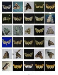
![District State [Species]Genus SpeciesName ... - Insects of Iowa](https://img.yumpu.com/12292306/1/190x146/district-state-speciesgenus-speciesname-insects-of-iowa.jpg?quality=85)